
Utah is a state in the Mountain West subregion of the Western United States. Utah is a landlocked U.S. state bordered to its east by Colorado, to its northeast by Wyoming, to its north by Idaho, to its south by Arizona, and to its west by Nevada. Utah also touches a corner of New Mexico in the southeast. Of the fifty U.S. states, Utah is the 13th-largest by area; with a population over three million, it is the 30th-most-populous and 11th-least-densely populated. Urban development is mostly concentrated in two areas: the Wasatch Front in the north-central part of the state, which is home to roughly two-thirds of the population and includes the capital city, Salt Lake City; and Washington County in the southwest, with more than 180,000 residents. Most of the western half of Utah lies in the Great Basin.

Orem is a city in Utah County, Utah, United States, in the northern part of the state. It is adjacent to Provo, Lindon, and Vineyard and is approximately 45 miles (72 km) south of Salt Lake City. Orem is one of the principal cities of the Provo-Orem, Utah Metropolitan Statistical Area, which includes all of Utah and Juab counties. The 2020 population was 98,129, while the 2010 population was 88,328 making it the fifth-largest city in Utah. Utah Valley University is located in Orem.

Sanpete County is a county in the U.S. state of Utah. As of the 2010 United States Census, the population was 27,822. Its county seat is Manti, and its largest city is Ephraim. The county was created in 1850.

Logan is a city in Cache County, Utah, United States. The 2020 census recorded the population was 52,778. By 2050 the population of Logan is expected to double. Logan is the county seat of Cache County and the principal city of the Logan metropolitan area, which includes Cache County and Franklin County, Idaho. The Logan metropolitan area contained 125,442 people as of the 2010 census and was declared by Morgan Quitno in 2005 and 2007 to be the safest in the United States in those years. Logan also is the location of the main campus of Utah State University.
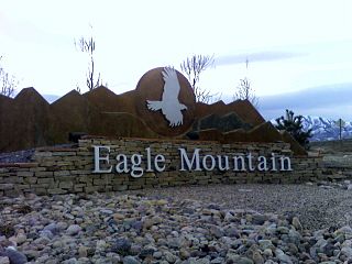
Eagle Mountain is a city in Utah County, Utah. It is part of the Provo–Orem metropolitan area. The city is located to the west as well as north of the Lake Mountains, which are west of Utah Lake. It was incorporated December 3, 1996 and has been rapidly growing ever since. The population was 43,623 at the 2020 census. Although Eagle Mountain was a town in 2000, it has since been classified as a fourth-class city by state law. In its short history, the city has quickly become known for its rapid growth.

Park City is a city in Summit County, Utah, United States. It is considered to be part of the Wasatch Back. The city is 32 miles (51 km) southeast of downtown Salt Lake City and 20 miles (32 km) from Salt Lake City's east edge of Sugar House along Interstate 80. The population was 8,396 at the 2020 census. On average, the tourist population greatly exceeds the number of permanent residents.

The Wasatch Range or Wasatch Mountains is a mountain range in the western United States that runs about 160 miles (260 km) from the Utah-Idaho border south to central Utah. It is the western edge of the greater Rocky Mountains, and the eastern edge of the Great Basin region. The northern extension of the Wasatch Range, the Bear River Mountains, extends just into Idaho, constituting all of the Wasatch Range in that state.

Bear Lake is a natural freshwater lake on the Idaho–Utah border in the Western United States. About 109 square miles (280 km2) in size, it is split about equally between the two states; its Utah portion comprises the second-largest natural freshwater lake in Utah, after Utah Lake. The lake has been called the "Caribbean of the Rockies" for its unique turquoise-blue color, which is due to the refraction of calcium carbonate (limestone) deposits suspended in the lake. Its water properties have led to the evolution of several unique species of fauna that occur only within the lake. Bear Lake is over 250,000 years old. It was formed by fault subsidence that continues today, slowly deepening the lake along the eastern side. In 1911 the majority of the flow of the Bear River was diverted into Bear Lake via Mud Lake and a canal from Stewart Dam, ending 11,000 years of separation between the lake and that river system.

Deer Valley is an alpine ski resort in the Wasatch Range, located 36 miles (58 km) east of Salt Lake City, in Park City, Utah, United States. The resort, known for its upscale amenities, is consistently ranked among the top ski resorts in North America.
Saltair, also The SaltAir, Saltair Resort, or Saltair Pavilion, is the name that has been given to several resorts located on the southern shore of the Great Salt Lake in Utah, United States, about 15 miles (24 km) from Salt Lake City.

Soldier Hollow is a cross-country ski venue located at the mouth of a hollow of the same name about 53 miles (85 km) southeast of Salt Lake City in Wasatch Mountain State Park in northwestern Wasatch County, Utah, United States. The venue was created for the 2002 Winter Olympics, and during the games it hosted the biathlon, cross-country skiing, and the cross country skiing portion of the Nordic combined events. Since hosting the Olympics, it has been developed as a cross-country skiing, tubing, and snowshoeing venue, while featuring mountain biking and golfing in the summer. On May 1, 2016, the venue operation contract transferred from the Soldier Hollow Legacy Foundation to the Utah Olympic Legacy Foundation, which owns and operates several Olympic and Paralympic legacy venues elsewhere in the state.

Palisades Interstate Park and its governing body, the Palisades Interstate Park Commission, was formed under an interstate compact in 1900 by governors Theodore Roosevelt of New York and Foster M. Voorhees of New Jersey in response to the destruction of the Palisades by quarry operators in the late 19th century. The Palisades are the cliffs on the west bank of the Hudson River across from and continuing north of Manhattan Island. The commission consists of ten commissioners, five appointed by each governor, who serve staggered five-year terms.

Palisades Tahoe is a ski resort in the western United States, located in Olympic Valley, California, northwest of Tahoe City in the Sierra Nevada range. From its founding in 1949 until 2021, the resort was known as Squaw Valley, but changed its name due to the derogatory meaning of squaw to Native Americans and their allies. It was the host site for the 1960 Winter Olympics.

Snowbasin Resort is a ski resort in the western United States, located in Weber County, Utah, 33 miles (53 km) northeast of Salt Lake City, on the back (east) side of the Wasatch Range.

Solitude Mountain Resort is a ski resort located in the Big Cottonwood Canyon of the Wasatch Mountains, thirty miles southeast of Salt Lake City, Utah. With 66 trails, 1,200 acres (4.9 km2) and 2,047 feet (624 m) vertical, Solitude is one of the smaller ski resorts near Salt Lake City, along with its neighbor Brighton. It is a family-oriented mountain, with a wider range of beginner and intermediate slopes than other nearby ski resorts; 50% of its slopes are graded "beginner" or "intermediate," the highest such ratio in the Salt Lake City area. Solitude was one of the first major US resorts to adopt an RFID lift ticket system, allowing lift lines to move more efficiently. It was followed by Alta Ski Area in 2007. Solitude is adjacent to Brighton Ski Resort near the top of Big Cottonwood Canyon. Solitude and Brighton offer a common "Solbright Pass" which provides access to both resorts for a nominal surcharge.
Beaver Mountain is a ski area in the western United States, in northern Utah. First opened 83 years ago in 1939, it is located near the summit of Logan Canyon in the Bear River Mountains, west of Bear Lake and near the border with Idaho. While smaller and less developed than a number of Utah ski resorts, Beaver Mountain is very popular with residents of nearby Logan, Utah State University, the surrounding Cache Valley, and the Bear Lake region, including southeastern Idaho.

Provo Canyon is located in unincorporated Utah County and Wasatch County, Utah. Provo Canyon runs between Mount Timpanogos on the north and Mount Cascade on the south. The canyon extends from Orem on the west end to Heber City on the east. Provo Canyon is situated to the east of Utah Valley and grants access to the valleys and Uinta Basin regions that lie beyond the Wasatch front.
The economy of Utah is a diversified economy covering industries such as tourism, mining, agriculture, manufacturing, information technology, finance, and petroleum production. The majority of Utah's gross state product is produced along the Wasatch Front, containing the state capital Salt Lake City.
Cherry Peak is a ski area in northern Utah that opened in 2014 and first used for skiing in the 2015–2016 season. It is located in Cherry Canyon, east of Richmond, Utah in the Bear River Mountains. While smaller and less developed than a number of Utah ski resorts, Cherry Peak is close and convenient to residents of nearby Logan, Utah State University, and Cache Valley. It also hosts students from more distant universities.


