Athens County is a county in southeastern Ohio. As of the 2020 census, the population was 62,431. Its county seat and largest city is Athens. The county was formed in 1805 from Washington County. Because the original state university was founded there in 1804, the town and the county were named for the ancient center of learning, Athens, Greece.

Glouster is a village in Trimble Township, Athens County, Ohio, United States. The population was 1,659 at the 2020 census. It is close to Burr Oak State Park.

Sunday Creek is a tributary of the Hocking River, 27.2 miles (43.8 km) long, in southeastern Ohio in the United States. Via the Hocking and Ohio Rivers, it is part of the watershed of the Mississippi River, draining 139 square miles (360 km²) in a mainly rural area of the Allegheny Plateau region. Its name is locally said to derive from early white settlers who in 1802 reached the creek on a Sunday, and so named it after the day of their discovery.

This is a list of properties and districts in Indiana that are listed on the National Register of Historic Places. There are over 1,900 in total. Of these, 39 are National Historic Landmarks. Each of Indiana's 92 counties has at least two listings.

This is a list of properties and districts in Ohio that are listed on the National Register of Historic Places. There are over 4.000 in total. Of these, 73 are National Historic Landmarks. There are listings in each of Ohio's 88 counties.

Harpersfield Bridge is a covered bridge spanning the Grand River in Harpersfield Township, Ashtabula County, Ohio, United States. * Currently disassembled for renovation 2023 * This double-span Howe truss bridge, one of currently 17 drivable covered bridges in the county, is the third longest covered bridge in Ohio at 228 feet. A flood in 1913 washed away the land at the north end of the bridge, and the steel span was subsequently attached. The bridge features a walkway, added during its renovation in 1991–1992. The bridge also features an Ashtabula County MetroPark at its north end, and is listed on the National Register of Historic Places. The bridge's WGCB number is 35-04-19, and it is located approximately 3.4 miles south of Geneva.

The B & O Railroad Potomac River Crossing is a 15-acre (6.1 ha) historic site where a set of railroad bridges, originally built by the Baltimore and Ohio Railroad, span the Potomac River between Sandy Hook, Maryland and Harpers Ferry, West Virginia. The site was added to the National Register of Historic Places on February 14, 1978, for its significance in commerce, engineering, industry, invention, and transportation.
The Root Covered Bridge is a historic wooden covered bridge in the southeastern part of the U.S. state of Ohio. Located off State Route 555 in far northern Decatur Township, Washington County, the bridge was built in 1878 in the Long truss mode of truss bridge construction. Measuring 65 feet (20 m) in its single span, it spans the West Branch of the Little Hocking River.

The Teegarden-Centennial Covered Bridge is a covered bridge in Columbiana County, Ohio. The bridge crosses Little Beaver Creek on Eagleton Road, 0.1 miles East of county road 411 near Salem, Ohio. It is currently only open to pedestrian traffic.

The Church Hill Road Covered Bridge is a covered bridge in Columbiana County, Ohio. It was originally located over Middle Fork Little Beaver Creek in Elk Township. The bridge was constructed in 1870 and was relocated in 1982 behind a restaurant on Ohio State Route 154 in Elkton, Ohio.

The Chain Lakes Bridge is a historic structure located southeast of Palo, Iowa, United States. It carries a pedestrian trail for 370 feet (110 m) over the Cedar River. The Linn County Board of Supervisors began planning for this span in the early 1880s. They appropriated $20,000 for this two-span Pratt through truss The Wrought Iron Bridge Company of Canton, Ohio, which built bridges in the county since 1879, completed this structure in 1884. The bridge was listed on the National Register of Historic Places in 1998. While it was built to carry vehicular traffic, it is now in a nature preserve maintained by the Linn County Conservation Board.

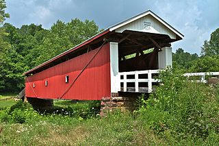
The Blackwood Covered Bridge, over the Shade River near Athens, Ohio, was built in 1881. It is a King post truss bridge. It was listed on the National Register of Historic Places in 1978.

The Newton Falls Covered Bridge, in Newton Falls, Ohio, was built around 1831. It was listed on the National Register of Historic Places in 1974. It is also known as the Arlington Boulevard Covered Bridge.

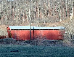
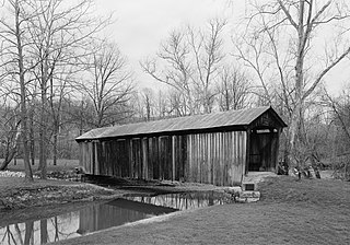
The Kidwell Covered Bridge, in Dover Township, Athens County, Ohio between the nearby hamlets of Truetown and Redtown, was built in 1880. It spans Sunday Creek. It was listed on the National Register of Historic Places in 1977.

The Knowlton Covered Bridge, near Rinard Mills, Ohio, was built around 1860. It was listed on the National Register of Historic Places in 1980. It was decommissioned shortly after. Also known as the Long Covered Bridge, it is a Burr arch truss bridge.

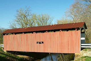
The Martinsville Road Covered Bridge, west of Martinsville, Ohio in Clark Township, Clinton County, Ohio, was built in 1871. It was listed on the National Register of Historic Places in 1974.
The Reed Bridge, near Marysville, Ohio, was a Partridge truss covered bridge. It was listed on the National Register of Historic Places in 1975.
The Rinard Covered Bridge, near Marietta, Ohio, was built in 1876. It was listed on the National Register of Historic Places in 1976.
The Salt Creek Covered Bridge, near Norwich in Perry Township, Muskingum County, Ohio, was built in 1876. It was listed on the National Register of Historic Places in 1974.