Paonta Sahib

Last updated

Paonta Sahib
Town
India Himachal Pradesh location map.svg
Red pog.svg
Paonta Sahib
Location in Himachal Pradesh
India location map.svg
Red pog.svg
Paonta Sahib
Paonta Sahib (India)
Coordinates: 30°26′17″N77°37′26″E / 30.438°N 77.624°E / 30.438; 77.624
CountryIndia
State Himachal Pradesh
District Sirmaur
MunicipalitySirmaur
Elevation
389 m (1,276 ft)
Population
 (2011)
  Total25,183 [1]
  Rank 8 in HP
Languages
Time zone UTC+5:30 (IST)
Vehicle registration HP17

Paonta Sahib is an industrial town of Himachal Pradesh in India. It is located in the south of Sirmaur district, on National Highway 72 ( New NH 7). Paonta Sahib is an important place of worship for Sikhs, hosting a large Gurdwara named Gurudwara Paonta Sahib, on the banks of the river Yamuna. The river is the boundary between the states of Himachal Pradesh and Uttarakhand.

Contents

History

The town was founded by Sikh Guru Shri Guru Gobind Singh Ji. [2] The Gurudwara Paonta Sahib has linkages to the tenth Sikh Guru, Shri Guru Gobind Singh Ji and the Sikh leader Banda Singh Bahadur. Its original name was Paontika. In Hindi language, Paon means "feet" and tika means "became stable". It is believed that Shri Guru Gobind Singh Ji and his horse stopped at this place, and he decided to stay here. He lived here for four and a half years, having never stayed so long at any other place in his entire life. He wrote many Sikh religious books during the stay and moved to Anandpur Sahib to establish the Khalsa Panth. The Gurudwara houses a museum containing antiques and weapons used by Shri Guru Gobind Singh Ji. Paonta Sahib is the birthplace of Sahibzada Ajit Singh Ji, the eldest son of Shri Guru Gobind Singh Ji.

Paonta Sahib as seen from Baba Bhure Shah's Dargah on the Uttarakhand Himachal border PaontaSahib.JPG
Paonta Sahib as seen from Baba Bhure Shah's Dargah on the Uttarakhand Himachal border

Geography

Paonta Sahib is located at 30°26′17″N77°37′26″E / 30.438°N 77.624°E / 30.438; 77.624 . [3] It has an average elevation of 389 metres (1,276 feet). It is on the bank of the river Yamuna, the river being the boundary between the states of Himachal Pradesh and Uttarakhand. It is situated near the towns of Nahan in Himachal Pradesh, Yamunanagar in Haryana, Saharanpur in Western Uttar Pradesh and Dehradun in Uttarakhand. It is on the western extreme of the Doon Valley, which is at a distance of about 44  km from Dehradun. Kalesar National Park is 12 km from Paonta Sahib. Colonel Sher Jung National Park is around 7 km from the main town. Some luxury hotels to stay in Paonta Sahib are Hotel Guru Surbhi, Hotel Yamuna, and Hotel Paonta Valley.

Climate

Paonta Sahib has a sub-tropical continental monsoon climate characterised by a seasonal rhythm, hot summers, slightly cold winters, unreliable rainfall and great variation in temperature (1 °C to 40 °C). In winter, frost sometimes occurs during December and January. It also receives occasional winter rains from the western disturbance.

Average temperatures:

Demographics

As of the 2011 Census of India, [4] Paonta Sahib had a population of 1,58,268 (urban 25,172/ rural 1,33,096). Males constitute 53% of the population and females 47%. [5] Paonta Sahib has an average literacy rate of 76%, higher than National average of 74.04% (2011 figure).: male literacy is 79%, and female literacy is 72%. In Paonta Sahib, 13% of the population is under 6 years of age.

Paonta Sahib is a municipal council which has 13 wards. This council looks after the development of the city, maintenance of roads, streets, cleanliness etc. The election takes place every five years to elect ward members and a chairman.

Religion in Paonta Sahib
ReligionPercent
Hinduism
78.63%
Sikhism
15.01%
Islam
5.04%
Christianity
0.29%
Others
1.01%

Industries

Major industries are cement (Cement Corporation of India in Rajban), power generation - renewable energy (Power Group ), aviation (Air Himalayas ), pharmaceutical (Sun Pharmaceutical, [6] Mankind Pharma Limited), textiles, and chemicals. Apart from these, Asia's biggest limestone market [7] is located at Sataun. Apart, Pharma Industry includes Tirupati Medicare Limited, Tirupati Life Sciences Pvt. Ltd., Tirupati Wellness Pvt. Ltd. and Pontika Aerotech Limited, all 4 are part of 'The Tirupati Group' in Paonta Sahib on Nahan Road.

Related Research Articles

<span class="mw-page-title-main">Sirmaur district</span> A district in Himachal Pradesh, India

Sirmaur district is the southernmost district of Himachal Pradesh, northern India. It is largely mountainous and rural, with 90% of its population living in villages. Some of its towns include the capital Nahan, Paonta Sahib, LANA PALAR, Tuheri, Bhawan, Shamra, UchaTikker and Suketi, the latter known for Shivalik Fossil Park.

<span class="mw-page-title-main">Yamunanagar</span> City in Haryana, India

Yamunanagar, is a city and a municipal corporation in Yamunanagar district in the Indian state of Haryana. This town is known for the cluster of plywood units and paper factories. It provides timber to larger industries. The older town is called Jagadhri. The Yamunanagar-Jagadhri railway station (YJUD) services the city. Despite its name, Jagadhri Railway is situated in Yamunanagar. There is also another railway station called Jagadhri Workshop in Yamunanagar.

<span class="mw-page-title-main">Nahan</span> A town in Himachal Pradesh, India

Nahan is a town in Himachal Pradesh in India and is the headquarters of the Sirmaur District It was the capital of the former Sirmur princely state.Nahan is also known as the Town of ponds.

<span class="mw-page-title-main">Una, Himachal Pradesh</span> City in Himachal Pradesh, India

Una is a City and a Municipal Council in Una district in the Indian state of Himachal Pradesh. It serves as the headquarters of Una district. There are 11 wards under Municipal Council. Una City is home to the Kila, which is a historical fort and an ancestral home of the descendants of the first guru of the Sikhs, Guru Nanak.

<span class="mw-page-title-main">Anandpur Sahib</span> City in Punjab, India

Anandpur Sahib, also referred simply as Anandpur, is a city in Rupnagar district (Ropar), on the edge of Shivalik Hills, in the Indian state of Punjab. Located near the Sutlej River, the city is one of the most sacred religious places in Sikhism, being the place where the last two Sikh Gurus, Guru Tegh Bahadur and Guru Gobind Singh, lived. It is also the place where Guru Gobind Singh founded the Khalsa Panth in 1699. The city is home to Takhat Sri Kesgarh Sahib, the third of the five Takhts in Sikhism.

Nadaun is a historical town and a nagar panchayat in the Hamirpur district of Himachal Pradesh, India. Previously a part of the princely state of Kangra, Nadaun is presently an independent small town located on NH 3 and NH 303 in the Sivalik range foothills. It is situated on the banks of the Beas.

<span class="mw-page-title-main">Raipur Rani</span> Census Town in Haryana, India

Raipur Rani is a census town in Panchkula district in the Indian state of Haryana. It is located on the Panchkula city-Chandigarh-Nahan-Paonta Sahib-Dehradun highway 30 kilometres east from the Chandigarh-Mohali-Panchkula urban cities combine. It is about 20 kilometres from the Dera Bassi Industrial belt and 10 kilometres from the Barwala industrial estate. Narayangarh in the Ambala District is the next large town in its proximity.

Sri Hargobindpur is a town and a municipal council in Gurdaspur district in the Indian state of Punjab. Situated on the banks of the Beas River Sixth Guru of Sikhs Shri Guru Hargobind Sahib ji established this city on the land bought by his Father and fifth Guru, Shri Guru Arjan Dev Sahib ji, the city is also the erstwhile capital of the Ramgarhia Misl.

Urmar Tanda is a town and municipal council in Hoshiarpur district, Punjab, India.

Vikasnagar is a city and a municipality in Dehradun district in the Indian state of Uttarakhand. Vikas Nagar is also a tehsil in Dehradun district

Giddarbaha is a town and a municipal council in Muktsar district, in the Indian state of Punjab. It is 19 kilometres (12 mi) from the city of Malout, 30 kilometres (19 mi) from the city of Bathinda and 40 kilometres (25 mi) from the city of Muktsar. It lies on NH-7, which connects Fazilka (Punjab) to Mana (Uttarakhand) in India.

<span class="mw-page-title-main">Nada Sahib</span> Gurdwara in Haryana India

Nada Sahib is a Sikh gurudwara in the Panchkula district of the Indian state of Haryana. Situated on the banks of the Ghaggar-Hakra River in the Sivalik Hills of Panchkula, it is the site where Guru Gobind Singh Ji halted while travelling from Paonta Sahib to Anandpur Sahib after the Battle of Bhangani in 1688.

The Battle of Bhangani was fought between Guru Gobind Singh's army and Bhim Chand (Kahlur) of Bilaspur on 18 September 1686 or 1688, at Bhangani near Paonta Sahib. An alliance of Rajput Rajas of the Shivalik Hills participated in the engagement on behalf of Bhim Chand of Bilaspur State's side, including the states of Garhwal and Kangra. It was the first battle Guru Gobind Singh, the tenth Sikh Guru, fought at the age of 19.

<span class="mw-page-title-main">Gurdwara Paonta Sahib</span> Sikh worship place in Sirmour, India

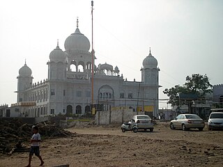
Gurdwara Paonta Sahib is a noted gurdwara in Paonta Sahib, district of Sirmaur, Himachal Pradesh.

Mat Prakash, also known as Medini Prakash, was a king of Sirmur State in present-day Himachal Pradesh, India. He ruled from 1684 until his death in 1704.

Lohgarh is a historic town in Bilaspur tehsil of Yamunanagar district of Haryana in India. It was the capital of First Sikh State under Baba Banda Singh Bahadur from 1710 to 1716.

<span class="mw-page-title-main">Ram Rai</span>

Ram Rai was the excommunicated eldest son of the seventh Sikh Guru, Guru Har Rai, and the founder of the Ramraiyas, an unorthodox and heretical sect in Sikhism.

The Battle of Anandpur (1685) was fought between the Sikhs and an allied force of rajas of the Hill States of the Sivalik range, specifically Kahlur, Kangra, and Guler.

References

  1. "Census of India: Population Finder - 2001". Archived from the original on 13 November 2016. Retrieved 17 August 2016.
  2. "Gurudwara Paonta Sahib - History Of Gurudwara Paonta Sahib - How To Reach Gurudwara Paonta Sahib". Religions.iloveindia.com. Retrieved 22 April 2019.
  3. "Maps, Weather, and Airports for Paonta Sahib, India". Fallingrain.com. Retrieved 22 April 2019.
  4. "Distribution of sub-districts by range of rural-urban decadal growth rate of population : Himachal Pradesh, 2001-2011" (PDF). Censusindia.gov.in. Retrieved 22 April 2019.
  5. "Distribution of sub-districts by range of sex ratio by residence : Himachal Pradesh, 2001 & 2011" (PDF). Censusindia.gov.in. Retrieved 22 April 2019.
  6. "Manufacturing - Sun Pharmaceutical Industries Ltd". Sunpharma.com. Retrieved 22 April 2019.
  7. Justification for Locating the Project | NIC