Parishville, New York

Last updated

Parishville
Parishville NY Locator Map.png
Map highlighting Parishville's location within St. Lawrence County.
New York Adirondack.svg
Red pog.svg
Parishville
Location within the state of New York
Coordinates: 44°35′53″N74°51′0″W / 44.59806°N 74.85000°W / 44.59806; -74.85000
CountryUnited States
State New York
County St. Lawrence
Area
[1]
  Total101.43 sq mi (262.70 km2)
  Land98.11 sq mi (254.11 km2)
  Water3.32 sq mi (8.59 km2)
Elevation
1,102 ft (336 m)
Population
 (2010) [2]
  Total2,153
  Estimate 
(2016) [3]
2,078
  Density21.18/sq mi (8.18/km2)
Time zone UTC-5 (Eastern (EST))
  Summer (DST) UTC-4 (EDT)
FIPS code 36-56374
GNIS feature ID0979343

Parishville is a town in the east-central part of St. Lawrence County, east of Potsdam, in the state of New York, United States. The population was 2,153 at the 2010 census. [2]

Contents

History

The town was laid out in 1809 on a tract of land that David Parish had purchased from J. D. Le Ray de Chaumont in 1808. [4] The first settlers arrived around 1810.

The town was formed in 1814 from the town of Hopkinton. The town was named for David Parish. [4] In 1843, part of Parishville was used to form the town of Colton.

The Luke Brown House was listed on the National Register of Historic Places in 2003. [5]

Geography

According to the United States Census Bureau, the town has a total area of 101.4 square miles (263 km2), of which 98.2 square miles (254 km2) is land and 3.2 square miles (8.3 km2) (3.20%) is water.

The town is situated partly in the Adirondack Park.

The West Branch of the St. Regis River flows northward through the town. The Raquette River flows through the southern part of Parishville.

New York State Route 72 is an east–west highway in the north part of the town. New York State Route 56 cuts across the southwestern corner of the town.

Demographics

Historical population
CensusPop.Note
1820 594
1830 1,479149.0%
1840 2,25052.1%
1850 2,132−5.2%
1860 2,2967.7%
1870 2,241−2.4%
1880 2,3846.4%
1890 2,272−4.7%
1900 2,086−8.2%
1910 1,785−14.4%
1920 1,453−18.6%
1930 1,284−11.6%
1940 1,3091.9%
1950 1,245−4.9%
1960 1,47318.3%
1970 1,63110.7%
1980 1,95119.6%
1990 1,901−2.6%
2000 2,0497.8%
2010 2,1535.1%
2016 (est.)2,078 [3] −3.5%
U.S. Decennial Census [6]

As of the census of 2000, there were 2,049 people, 797 households, and 564 families residing in the town. The population density was 20.9 people per square mile (8.1/km2). There were 1,204 housing units at an average density of 12.3 per square mile (4.7/km2). The racial makeup of the town was 98.98% White, 0.05% African American, 0.29% Native American, 0.15% Asian, 0.10% from other races, and 0.44% from two or more races. Hispanic or Latino of any race were 0.73% of the population. [2]

There were 797 households, out of which 33.9% had children under the age of 18 living with them, 56.5% were married couples living together, 9.3% had a female householder with no husband present, and 29.2% were non-families. 23.3% of all households were made up of individuals, and 9.4% had someone living alone who was 65 years of age or older. The average household size was 2.57 and the average family size was 3.02. [2]

In the town, the population was spread out, with 27.4% under the age of 18, 6.8% from 18 to 24, 29.1% from 25 to 44, 25.6% from 45 to 64, and 11.0% who were 65 years of age or older. The median age was 37 years. For every 100 females, there were 98.7 males. For every 100 females age 18 and over, there were 95.9 males. [2]

The median income for a household in the town was $32,210, and the median income for a family was $37,981. Males had a median income of $30,842 versus $22,938 for females. The per capita income for the town was $14,924. About 6.1% of families and 10.7% of the population were below the poverty line, including 13.3% of those under age 18 and 7.9% of those age 65 or over. [2]

Communities and locations in Parishville

The character Rose Lalonde in the webcomic Homestuck lives in a fictional house over Rainbow Falls in Parishville. [7]

Related Research Articles

<span class="mw-page-title-main">Black Brook, New York</span> Town in New York, United States

Black Brook is a town in Clinton County, New York, United States. The population was 1,497 at the 2010 census. It is named after a stream that flows through the town.

<span class="mw-page-title-main">Saranac, New York</span> Town in New York, United States

Saranac is a town in Clinton County, New York, United States. The town is on the western border of the county, west of Plattsburgh, and is within the Adirondack Park. The population was 4,007 at the 2010 census. The town is named for the Saranac River that flows through the town.

<span class="mw-page-title-main">Keene, New York</span> Town in New York, United States

Keene is a town in central Essex County, New York, United States. It includes the hamlets of Keene, Keene Valley, and St. Huberts, with a total population of 1,144 as of the 2020 census

<span class="mw-page-title-main">Franklin, Franklin County, New York</span> Town in New York, United States

Franklin is a town located in Franklin County, New York, United States. As of the 2010 census, the town had a population of 1,140.

<span class="mw-page-title-main">Waverly, Franklin County, New York</span> Town in New York, United States

Waverly is a town in Franklin County, New York, United States. The population was 1,022 at the 2010 census. The town is on the western border of the county, southwest of Malone.

Oppenheim is a town in Fulton County, New York, United States. The town is in the southwestern corner of the county and is east of Utica. The population was 1,924 at the 2010 census.

<span class="mw-page-title-main">Webb, New York</span> Town in New York, United States

Webb is the northernmost town in Herkimer County, New York, United States. As of the 2010 census it had a population of 1,807.

Lyonsdale is a town in Lewis County, New York, United States. The population was 1,227 at the 2010 census. The town is named after its principal community and its founder Caleb Lyon.

Watson is a town in Lewis County, New York, United States. The population was 1,881 at the 2010 census. The town is named after early landowner James Watson. The town is at the eastern border of the county and is east of Lowville, the county seat.

<span class="mw-page-title-main">Halfmoon, New York</span> Town in New York, United States

Halfmoon is a town in Saratoga County, New York, United States. The population was 25,662 at the 2020 census. The town is apparently named for the shape of the lower elevation land north of the junction of the Hudson and Mohawk Rivers. It is also said to be named for Henry Hudson's ship, the Halve Maen.

<span class="mw-page-title-main">Moreau, New York</span> Town in New York, United States

Moreau is a town in Saratoga County, New York, United States. The population was 16,202 at the 2020 census. The town is located in the northeast part of the county, north of Saratoga Springs. Moreau is named after Jean Victor Moreau, a French general, who visited the area just before the town was formed. The town contains a village called South Glens Falls.

<span class="mw-page-title-main">Clifton, New York</span> Town in New York, United States

Clifton is a town in St. Lawrence County, New York, United States. The population was 675 at the 2020 census. The town takes its name from a mining company.

<span class="mw-page-title-main">Colton, New York</span> Town in New York, United States

Colton is a town in St. Lawrence County, New York, United States. The population was 1,451 at the 2010 census. The town, originally named "Matildaville", is named after early settler Jesse Colton Higley.

<span class="mw-page-title-main">Hopkinton, New York</span> Town in New York, United States

Hopkinton is a town in St. Lawrence County, New York, United States. The population was 1,105 at the 2020 census and has a Population density of 5.9 square miles. The town is named for Roswell Hopkins, a pioneer settler and a government official.

<span class="mw-page-title-main">Piercefield, New York</span> Town in New York, United States

Piercefield is a town in St. Lawrence County, New York, United States. The population was 310 at the 2010 census.

<span class="mw-page-title-main">Horicon, New York</span> Town in New York, United States

Horicon is a town in Warren County, New York, United States. It is part of the Glens Falls Metropolitan Statistical Area. Horicon's population was 1,389 at the 2010 census.

<span class="mw-page-title-main">Dresden, Washington County, New York</span> Town in New York, United States

Dresden is a town in northern Washington County, New York, United States. It is part of the Glens Falls Metropolitan Statistical Area. The town population was 677 at the 2000 census.

<span class="mw-page-title-main">Putnam, New York</span> Town in Washington County, New York, US

Putnam is a town in northern Washington County, New York, United States. It is part of the Glens Falls Metropolitan Statistical Area. The town population was 645 at the 2000 census. The town is named after Israel Putnam, a hero of the American Revolution.

<span class="mw-page-title-main">Plattsburgh (town), New York</span> Town in New York, United States

Plattsburgh is a town in Clinton County, New York, United States. The population was 11,886 at the 2020 census. The town is named after Zephaniah Platt, an early land owner, and it surrounds the separate and more populous city of the same name. The town is in the eastern part of the county, in the North Country region of the state of New York. The region's airport, Plattsburgh International Airport, is located in the southern part of the town.

<span class="mw-page-title-main">Little Falls (town), New York</span> Town in New York, United States

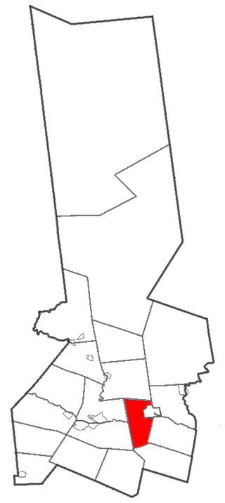
Little Falls is a town in Herkimer County, New York, United States. The population was 1,587 at the 2010 census. The town is named after falls and rapids on the Mohawk River nearby.

References

  1. "2016 U.S. Gazetteer Files". United States Census Bureau. Retrieved July 5, 2017.
  2. 1 2 3 4 5 6 "U.S. Census website". United States Census Bureau . Retrieved January 31, 2008.
  3. 1 2 "Population and Housing Unit Estimates" . Retrieved June 9, 2017.
  4. 1 2 History of Parishville, NY
  5. "National Register Information System". National Register of Historic Places . National Park Service. March 13, 2009.
  6. "Census of Population and Housing". Census.gov. Retrieved June 4, 2015.
  7. Hussie, Andrew. "Homestuck". Homestuck. Andrew Hussie. Retrieved December 21, 2018.