Park Crescent West ice well

Last updated

Park Crescent West ice well
Greater London UK location map 2.svg
Archaeological site icon (red).svg
Shown within Greater London
LocationCity of Westminster, England
Coordinates 51°31′20″N0°08′49″W / 51.5223°N 0.1470°W / 51.5223; -0.1470
OS grid reference TQ 28654 82004
TypeIce well
Diameter7.5m
Height9.5m
History
BuilderSamuel Dash
MaterialBrick
Founded1780
AbandonedMid-to-late 19th century
Site notes
Discovered2014
Archaeologists Museum of London Archaeology
ConditionExtant
Public accessLimited access
Official nameA subterranean commercial ice-well (City of Westminster), Park Crescent West, W1
Designated28 October 2015
Reference no. 1427239

The Park Crescent West ice well is a 9.5m deep underground brick structure in the City of Westminster, London, England. It was built by Samuel Dash in 1780 for the storage of ice gathered from local ponds and canals. The structure came into the ownership of William Leftwich, a leading figure in the London ice trade, who used it to store imported Norwegian ice which he sold to the food and drinks industry. The well was abandoned in the mid-to-late 19th century and covered over. It was rediscovered in good condition during development works in 2014. The well was listed as a scheduled monument in 2015 and there are plans to make it available for visits by the general public.

Contents

Description

The ice well is a 9.5m deep and 7.5m wide egg-shaped underground structure originally used for the storage of ice. [1] It is situated in the City of Westminster between the John Nash properties of Park Crescent West and buildings on Portland Place. [2] The site, just south of Regent's Park, is now one of London's most desirable areas. [1]

The structure was built of bricks with a London Clay lining, though the top metre of the structure was coated in a cement render and may have originally protruded from the ground. [1] [2] The brickwork, laid in English bond, is of a higher standard than that of the surrounding buildings. [1] [2] The main internal chamber may have originally been subdivided and access and ventilation was provided by a 650mm square hole at the top of the chamber, through which ice would have been raised and lowered. [2] The ice was insulated with hay and a drain was provided at the base of the chamber for the removal of meltwater. [1] [2] An above-ground entranceway, 1.3m wide and roofed with Yorkstone slabs, provided access to the chamber by means of a timber door. A side room off this entranceway may have been used as a vault for the storage of perishable goods. [2]

History

Ice wells or ice houses have been constructed in England since the 1600s as a means of preserving ice gathered from lakes and rivers in winter until the summer months. Most of the structures known today are located at country houses. [2] In 1780 Samuel Dash of Harley Street, who rented land in Park Crescent West, requested permission from his landlord – the Surveyor General of Woods, Forests, Parks, and Chases – to construct an underground "arch". [2] [3] This structure is presumed to have been the ice well. [3] Dash has no documented links to the sale of ice or any associated trades such as fish, pastry or ice cream but was a partner in a distillery. [3] Dash's ice was sourced from local ponds and canals but did not prove very popular as it contained foreign bodies. [4]

The well had been taken over by William Leftwich by early 1826. Leftwich was a pastry chef, confectioner and caterer who was a pioneer of the ice trade in London. [3] He imported 300 tons of high-quality Norwegian ice to London in 1822 and by 1825 was selling this and ice from local sources (including Regent's Canal) to London and the surrounding countryside. [3] His customers included coffee houses, inns, clubs, fishmongers and pastry chefs; he also sold his own ice-based confectionery. [2] Archaeologists suggest that Leftwich may also have supplied local medical practices and dentists on Harley Street and Wimpole Street, where ice was used to numb the skin prior to operations. [1] Leftwich claimed in an 1828 advertisement to sell the "best and clearest" ice in London. [3] He had outlets at Fleet Street and in Kingston upon Thames. [2] Leftwich acquired a larger ice well in Regent's Park in 1829 but seems to have retained the Park Crescent well for some time (though it was definitely out of his possession by his death in 1841). [3] Ice houses in general became redundant with the rise of refrigerators in the late 19th century; many were demolished or re-purposed for general storage or as wine cellars. [4]

Rediscovery

Approximate location of an 18th-century ice well behind Park Crescent West, London; the well is marked with a red triangle. Approx location of Ice well, Park Crescent west.png
Approximate location of an 18th-century ice well behind Park Crescent West, London; the well is marked with a red triangle.

The well was covered over during the construction of mews on the site in the mid-to-late 19th century and brick walls were laid on top of it. [2] The surrounding houses were destroyed by German bombing during the Blitz but the well was undamaged. [4] It was described as part of the mews property leased for use as a garage as late as 1952 but was lost by 1961 when it was briefly uncovered during construction works before being covered over once more with rubble. [3]

The site was being redeveloped in 2014 as part of a £500 million scheme by Great Marlborough Estates, and they commissioned a survey by the Museum of London Archaeology. [2] [4] This uncovered the ice well which was found to be in a good condition. [2] Historic England described the find as "a spectacular new discovery, astonishingly well-preserved and demonstrating the great engineering and construction abilities present towards the end of the 18th century" and it was noted to be "a rare example of a large, well-preserved urban ice-well". [2] [4] The structure was listed as a scheduled monument on 28 October 2015. [2] [3]

Full excavation of the rubble took three months, though further excavations may allow more of the entrance passageway to be exposed. [1] [2] It was also found that part of the London Underground's Jubilee Line passes beneath the eastern portion of the well. [2] Historic England and the developer have plans to install a corridor above the well that will allow for occasional viewing by the public. [1] [4]

Related Research Articles

<span class="mw-page-title-main">Paddington</span> Area of central London, England

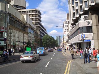
Paddington is an area in the City of Westminster, in central London, England. A medieval parish then a metropolitan borough, it was integrated with Westminster and Greater London in 1965. Paddington station, designed by the engineer Isambard Kingdom Brunel opened in 1847. It is also the site of St Mary's Hospital and the former Paddington Green Police Station.

<span class="mw-page-title-main">Regent's Park</span> Royal Park in London, England

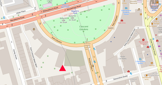
Regent's Park is one of the Royal Parks of London. It occupies 410 acres (170 ha) of high ground in north-west Inner London, administratively split between the City of Westminster and the Borough of Camden. In addition to its large central parkland and ornamental lake, it contains various structures and organizations both public and private, generally on its periphery, including Regent's University and London Zoo.

<span class="mw-page-title-main">Primrose Hill</span> Park in north-west London

Primrose Hill is a Grade II listed public park located north of Regent's Park in London, England, first opened to the public in 1842. It was named after the 64 metres (210 ft) natural hill in the centre of the park, the second highest natural point in the London Borough of Camden. The hill summit has a clear view of central London, as well as Hampstead and Belsize Park to the north and is adorned by an engraved quotation from William Blake. Based on the popularity of the park, the surrounding district and electoral ward were named Primrose Hill. The Primrose Hill district is in the London Borough of Camden, England.

<span class="mw-page-title-main">Maida Vale</span> Residential district in the northern part of Paddington, west London

Maida Vale is an affluent residential district consisting of the northern part of Paddington in West London, west of St John's Wood and south of Kilburn. It is also the name of its main road, on the continuous Edgware Road. Maida Vale is part of the City of Westminster, 3.1 miles (5.0 km) north-west of Charing Cross. It has many late Victorian and Edwardian blocks of mansion flats. The area is home to the BBC Maida Vale Studios.

<span class="mw-page-title-main">Limehouse Basin</span> Canal basin in Tower Hamlets, London

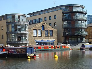
Limehouse Basin is a body of water 2 miles east of London Bridge that is also a navigable link between the River Thames and two of London's canals. First dug in 1820 as the eastern terminus of the new Regent's Canal, its wet area was less than 5 acres originally, but it was gradually enlarged in the Victorian era, reaching a maximum of double that size, when it was given its characteristic oblique entrance lock, big enough to admit 2,000-ton ships.

<span class="mw-page-title-main">Ice house (building)</span> Building used for storing ice all year round, before refrigeration

An ice house, or icehouse, is a building used to store ice throughout the year, commonly used prior to the invention of the refrigerator. Some were underground chambers, usually man-made, close to natural sources of winter ice such as freshwater lakes, but many were buildings with various types of insulation.

<span class="mw-page-title-main">London Canal Museum</span> Transport museum in London, England

London Canal Museum in the King's Cross area of London, England, is a regional museum devoted to the history of London's canals.

<span class="mw-page-title-main">Great Portland Street</span>

Great Portland Street in Marylebone, in the West End of London, links Oxford Street with the A501 Marylebone Road. The street, which is part of a broader rectilinear street pattern, includes the Embassy of the Democratic Republic of the Congo. and a number of small independent shops.

<span class="mw-page-title-main">Welbeck Street</span>

Welbeck Street is a street in the West End, central London. It has historically been associated with the medical profession.

<span class="mw-page-title-main">Rufford New Hall</span> Building in Rufford, England

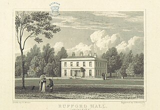
Rufford New Hall is a former country house that belonged to the Heskeths who were lords of the manor of Rufford, Lancashire, England. It replaced Rufford Old Hall as their residence in 1760. From 1920 to 1987 it was used as a hospital and has subsequently been restored and converted for residential use. It was designated a Grade II listed building in 1986.

<span class="mw-page-title-main">Cavendish Square</span>

Cavendish Square is a public garden square in Marylebone in the West End of London. It has a double-helix underground commercial car park. Its northern road forms ends of four streets: of Wigmore Street that runs to Portman Square in the much larger Portman Estate to the west; of Harley Street which runs an alike distance; of Chandos Street which runs for one block and; of Cavendish Place which runs the same. The south side itself is modern: the rear façade and accesses to a flagship department store and office block. On the ground floors facing are Comptoir Libanais, Royal Bank of Scotland and Pret a Manger premises.

<span class="mw-page-title-main">Cumberland Market</span>

Cumberland Market was a London market between Regent's Park and Euston railway station. It was built in the early 19th century and was London's hay and straw market for a hundred years until the late 1920s. An arm of the Regent's Canal was built to the market. The market was surrounded by modest housing, and in the early 20th century became an artistic community. The original houses were demolished during and after the Second World War and it is now a housing estate, known as Regent's Park Estate.

<span class="mw-page-title-main">A400 road (Great Britain)</span> Road in London

The A400 road is an A road in London that runs from Charing Cross to Archway in North London. It passes some of London's most famous landmarks.

<span class="mw-page-title-main">Park Crescent, London</span> Protected architecture in south of Regents Park.

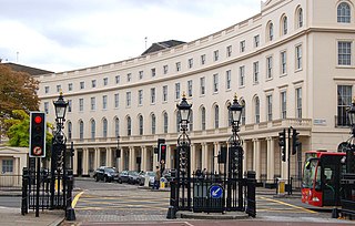
Park Crescent is at the north end of Portland Place and south of Marylebone Road in London. The crescent consists of elegant stuccoed terraced houses by the architect John Nash, which form a semicircle. The crescent is part of Nash's and wider town-planning visions of Roman-inspired imperial West End approaches to Regent's Park. It was originally conceived as a circus (circle) to be named Regent's Circus but instead Park Square was built to the north. The only buildings on the Regent's Park side of the square are small garden buildings, enabling higher floors of the Park Crescent buildings to have a longer, green northern view.

<span class="mw-page-title-main">Marylebone</span> Area in London, England

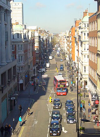
Marylebone is a district in the West End of London, in the City of Westminster. Oxford Street, Europe's busiest shopping street, forms its southern boundary.

<span class="mw-page-title-main">Bolsover Street</span> Street in City of Westminster, United Kingdom

Bolsover Street is in the Parish of St Marylebone in London’s West End. In administrative terms it lies within the City of Westminster's Marylebone High Street Ward and is partly in the Harley Street Conservation Area whilst also sitting on the edges of the Regents Park and East Marylebone Conservation Areas.

<span class="mw-page-title-main">Portland Place</span> Historic thoroughfare in the Marylebone district of London, England

Portland Place is a street in the Marylebone district of central London. Named after the Third Duke of Portland, the unusually wide street is home to the BBC's headquarters Broadcasting House, the Chinese and Polish embassies, the Royal Institute of British Architects and numerous residential mansion blocks.

<span class="mw-page-title-main">Little Venice</span> District in London, England

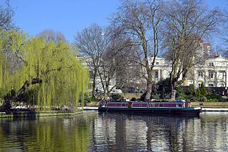
Little Venice is a district in West London, England, around the junction of the Paddington Arm of the Grand Union Canal, the Regent's Canal, and the entrance to Paddington Basin. The junction forms a triangular shape basin. Many of the buildings in the vicinity are Regency white painted stucco terraced town houses and taller blocks (mansions) in the same style. The area is 2.5 miles (4.0 km) west-north-west of Charing Cross and immediately north-west of Paddington.

This is a list of the etymology of street names in the London district of Marylebone. The following utilises the generally accepted boundaries of Marylebone viz. Marylebone Road to the north, Great Portland Street to the east, Marble Arch and Oxford Street to the south and Edgware Road to the west.

References

  1. 1 2 3 4 5 6 7 8 Addley, Esther (28 December 2018). "Chilling discovery: ice house found under London street". The Guardian. Retrieved 23 January 2019.
  2. 1 2 3 4 5 6 7 8 9 10 11 12 13 14 15 16 17 "A subterranean commercial ice-well (City of Westminster), Park Crescent West, W1 , Non Civil Parish – 1427239". Historic England.
  3. 1 2 3 4 5 6 7 8 9 "Park Crescent: John Nash, Charles Mayor and one of the severest bankruptcies in London building history" (PDF). University College London. Survey of London . Retrieved 23 January 2019.
  4. 1 2 3 4 5 6 Pickford, James (28 December 2018). "Georgian ice house found near Regent's Park in London". Financial Times. Archived from the original on 28 December 2018. Retrieved 23 January 2019.
  5. The map is superimposed over an OpenStreetMap outtake (issued under CC-BY-SA licence)