
Perquimans County is a county located in the U.S. state of North Carolina. As of the 2020 census, the population was 13,005. Its county seat is Hertford. The county was originally created as Berkeley Precinct. It was renamed Perquimans Precinct around 1684 and gained county status in 1739. Perquimans County is part of the Elizabeth City, NC Micropolitan Statistical Area, which is also included in the Virginia Beach-Norfolk, VA-NC Combined Statistical Area. The Harvey Point Defense Testing Activity facility is located in Perquimans County.

Northampton County is a county located in the U.S. state of North Carolina. As of the 2020 census, the population was 17,471. Its county seat is Jackson.

Hertford County is a county located in the U.S. state of North Carolina. As of the 2020 census, the population was 21,552. Its county seat is Winton. It is classified within the region known in the 21st century as the Inner Banks.

Gates County is a small, rural county located in the northeastern portion of the U.S. state of North Carolina, on the border with Virginia. As of the 2020 census, the population was 10,478. Its county seat is Gatesville. Gates County is included in the Virginia Beach-Norfolk-Newport News, VA-NC Metropolitan Statistical Area. It is part of the Albemarle Sound area of the Inner Banks.

Chowan County is one of the 100 counties located in the U.S. state of North Carolina. As of the 2020 census, the population was 13,708. Its county seat is Edenton. The county was created between 1668 and 1671 as Shaftesbury Precinct and later renamed Chowan Precinct. It gained county status in 1739.

Bertie County is a county located in the northeast area of the U.S. state of North Carolina. As of the 2020 census, the population was 17,934. Its county seat is Windsor. The county was created in 1722 as Bertie Precinct and gained county status in 1739.

Edenton is a town in, and the county seat of, Chowan County, North Carolina, United States, on Albemarle Sound. The population was 4,397 at the 2020 census. Edenton is located in North Carolina's Inner Banks region. In recent years Edenton has become a popular retirement location and a destination for heritage tourism.

Ahoskie is a town in Hertford County, North Carolina, United States. The population was 5,039 at the 2010 census. Ahoskie is located in North Carolina's Inner Banks region. Its nickname is "The Only One" because no other town in the world is known by the same name. The etymology of the word Ahoskie, which was originally spelled "Ahotsky," was from the Wyanoke Indians, who entered the Hertford County area at the beginning of European settlement.

Murfreesboro is a town in Hertford County, North Carolina, United States. The population was 2,835 at the 2010 census. The town is home to Chowan University.

Winton is a town and the county seat of Hertford County, North Carolina, United States. It is governed by the Town Council which consists of a Mayor and five Council members. The population was 769 at the 2010 census.

Hertford is a town and the county seat of Perquimans County, North Carolina, United States. The current population of Hertford, North Carolina is 1,912 based on the 2020 census. The US Census estimates the 2021 population at 1,925. The last official US Census in 2010 recorded the population at 2,143. Hertford is located in North Carolina's Inner Banks region and is part of both the Elizabeth City Micropolitan Statistical Area and the Hampton Roads region. It is named after the county town of Hertford, England.
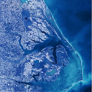
Albemarle Sound is a large estuary on the coast of North Carolina in the United States located at the confluence of a group of rivers, including the Chowan and Roanoke. It is separated from the Atlantic Ocean by the Currituck Banks, a barrier peninsula upon which the town of Kitty Hawk is located, at the eastern edge of the sound, and part of the greater Outer Banks region. Roanoke Island is situated at the southeastern corner of the sound, where it connects to Pamlico Sound. Much of the water in the Albemarle Sound is brackish or fresh, as opposed to the saltwater of the ocean, as a result of river water pouring into the sound.

The Meherrin Nation is one of seven state-recognized nations of Native Americans in North Carolina. They reside in rural northeastern North Carolina, near the river of the same name on the Virginia-North Carolina border. Historically the Iroquoian tribe had lived in the Piedmont of Virginia but moved south in the early 18th century under pressure from the encroachment of British colonists on their traditional homelands.

The Nottoway River is a river in the U.S. State of Virginia and northeastern North Carolina that is 155 miles in length. The river begins in Prince Edward County and merges with the Blackwater River to form the Chowan River in North Carolina. The river is part of the Chowan River system, which empties into the Albemarle Sound in North Carolina.

The Chowan River (cho-WAHHN) is a blackwater river formed with the merging of Virginia's Blackwater and Nottoway rivers near the stateline between Virginia and North Carolina. According to the USGS a variant name is Choan River.
The North Carolina Department of Transportation Ferry Division is a branch of NCDOT that is responsible for the operation of over two dozen ferry services that transport passengers and vehicles to several islands along the Outer Banks of North Carolina.
The Meherrin River is a 143.37 mi (230.73 km) long 6th order tributary to the Chowan River that joins in Hertford County, North Carolina.
The Sans Souci Ferry is a cable ferry that provides access across the Cashie River in Bertie County, North Carolina. Since the 1930s, the ferry has been operated by the North Carolina Department of Transportation.

Elwell Ferry is an inland cable ferry which has operated since 1905 on Elwell Ferry Road between NC Highway 53 and NC Highway 87, crossing the Cape Fear River and connecting the communities of Carvers Creek and Kelly in Bladen County, North Carolina.
Potecasi Creek is a 41.28 mi (66.43 km) long 4th order tributary to the Meherrin River in Hertford County, North Carolina. This is the only stream of this name in the United States.
