Hertford County, North Carolina

Last updated

Hertford County
Chowan College Administration Building, Murfreesboro, N. C. (5812043376).jpg
Chowan College Administration Building in Murfreesboro
Hertford County Flag.gif
Hertford County Seal.png
Map of North Carolina highlighting Hertford County.svg
Location within the U.S. state of North Carolina
North Carolina in United States.svg
North Carolina's location within the U.S.
Coordinates: 36°22′N76°59′W / 36.36°N 76.98°W / 36.36; -76.98
CountryFlag of the United States.svg United States
StateFlag of North Carolina.svg  North Carolina
Founded1759
Named for Francis Seymour-Conway, 1st Marquess of Hertford
Seat Winton
Largest community Ahoskie
Area
  Total360.40 sq mi (933.4 km2)
  Land353.16 sq mi (914.7 km2)
  Water7.24 sq mi (18.8 km2)  2.01%
Population
 (2020)
  Total21,552
  Estimate 
(2023)
19,453
  Density61.03/sq mi (23.56/km2)
Time zone UTC−5 (Eastern)
  Summer (DST) UTC−4 (EDT)
Congressional district 1st
Website www.hertfordcountync.gov

Hertford County is a county located in the U.S. state of North Carolina. As of the 2020 census, the population was 21,552. [1] Its county seat is Winton. [2] It is classified within the region known in the 21st century as the Inner Banks.

Contents

History

Hertford County is home of the Meherrin Indian Tribe, descendants of indigenous people who had inhabited the region for many centuries. After decades of encroachment by English colonists, the Tribe moved south from Virginia, where they settled in 1706 on a reservation abandoned by the Chowanoke. This six-square-mile reservation was at Parker's Ferry near the mouth of the Meherrin River. It was confirmed by a treaty of 1726. [3] However, they were not able to keep the reservation lands.

The Tribe today has approximately 900 enrolled members, most living within 10–15 miles of the former reservation. [3] The tribe is recognized by the state and is seeking Federal recognition. The Meherrin have an annual Pow Wow at the end of October.

The county was formed in 1759 from parts of Bertie County, Chowan County, and Northampton County. It was named for Francis Seymour-Conway, 1st Earl of Hertford, later 1st Marquess of Hertford. [4]

In 1779 the northeastern part of Hertford County was combined with parts of Chowan County and Perquimans County to form Gates County.

Geography

Hertford County, North Carolina
Interactive map of Hertford County

According to the U.S. Census Bureau, the county has a total area of 360.40 square miles (933.4 km2), of which 353.16 square miles (914.7 km2) is land and 7.24 square miles (18.8 km2) (2.01%) is water. [5]

State and local protected area

Major water bodies

Adjacent counties

Major highways

Major infrastructure

Demographics

Historical population
CensusPop.Note
1790 5,949
1800 6,70112.6%
1810 6,052−9.7%
1820 7,71227.4%
1830 8,53710.7%
1840 7,484−12.3%
1850 8,1428.8%
1860 9,50416.7%
1870 9,273−2.4%
1880 11,84327.7%
1890 13,85117.0%
1900 14,2943.2%
1910 15,4368.0%
1920 16,2945.6%
1930 17,5427.7%
1940 19,35210.3%
1950 21,45310.9%
1960 22,7185.9%
1970 23,5293.6%
1980 23,368−0.7%
1990 22,523−3.6%
2000 22,6010.3%
2010 24,6699.2%
2020 21,552−12.6%
2023 (est.)19,453 [1] −9.7%
U.S. Decennial Census [7]
1790–1960 [8] 1900–1990 [9]
1990–2000 [10] 2010 [11] 2020 [1]

2020 census

Hertford County racial composition [12]
RaceNumberPercentage
White (non-Hispanic)6,72131.19%
Black or African American (non-Hispanic)12,21556.68%
Native American 1880.87%
Asian 1130.52%
Pacific Islander 30.01%
Other/Mixed 7333.4%
Hispanic or Latino 1,5797.33%

As of the 2020 census, there were 21,552 people, 8,845 households, and 5,419 families residing in the county.

2010 census

At the 2010 census, [13] there were 24,669 people, 8,953 households, and 6,240 families residing in the county. The population density was 64 people per square mile (25 people/km2). There were 9,724 housing units at an average density of 28 units per square mile (11 units/km2). The racial makeup of the county was 60.5% Black or African American, 35.6% White, 1.1% Native American, 0.5% Asian, 0.0% Pacific Islander, 0.8% from other races, and 1.0% from two or more races. 1.4% of the population were Hispanic or Latino of any race.

There were 8,953 households, out of which 30.00% had children under the age of 18 living with them, 45.80% were married couples living together, 19.50% had a female householder with no husband present, and 30.30% were non-families. 26.90% of all households were made up of individuals, and 12.10% had someone living alone who was 65 years of age or older. The average household size was 2.48 and the average family size was 2.99.

In the county, the population was spread out, with 25.30% under the age of 18, 7.80% from 18 to 24, 26.30% from 25 to 44, 24.80% from 45 to 64, and 15.80% who were 65 years of age or older. The median age was 39 years. For every 100 females there were 85.00 males. For every 100 females age 18 and over, there were 79.50 males.

The median income for a household in the county was $26,422, and the median income for a family was $32,002. Males had a median income of $26,730 versus $20,144 for females. The per capita income for the county was $15,641. About 15.90% of families and 18.30% of the population were below the poverty line, including 21.30% of those under age 18 and 21.00% of those age 65 or over.

Government and politics

Hertford County is a member of the Mid-East Commission regional council of governments.

As of October 2022, 66 percent of registered voters in Hertford County are Democrats—the highest Democratic registration rate statewide—while Republicans have their lowest county registration rate. [14]

Rivers Correctional Institution, a private prison operated by the GEO Group which operates under contract from the Federal Bureau of Prisons and houses many felons who committed crimes in Washington, DC, is 1 mile (1.6 km) from Winton. [15]

United States presidential election results for Hertford County, North Carolina [16]
Year Republican Democratic Third party
No.%No.%No.%
2020 3,47932.72%7,09766.74%580.55%
2016 3,09930.42%6,91067.84%1771.74%
2012 3,00727.54%7,84371.84%680.62%
2008 3,08929.00%7,51370.54%480.45%
2004 2,94236.18%5,14163.22%490.60%
2000 2,38230.16%5,48469.44%310.39%
1996 1,82325.86%4,85668.89%3705.25%
1992 2,20828.78%4,60960.08%85511.14%
1988 2,97737.54%4,94362.33%100.13%
1984 3,17641.27%4,49858.45%210.27%
1980 1,85430.59%4,10267.69%1041.72%
1976 1,51727.53%3,98672.34%70.13%
1972 2,79458.34%1,92840.26%671.40%
1968 1,12517.04%3,27549.60%2,20333.36%
1964 99420.09%3,95379.91%00.00%
1960 78120.10%3,10579.90%00.00%
1956 72921.21%2,70878.79%00.00%
1952 57916.84%2,85983.16%00.00%
1948 1968.04%2,16588.80%773.16%
1944 1255.89%1,99694.11%00.00%
1940 923.60%2,46496.40%00.00%
1936 843.48%2,32796.52%00.00%
1932 884.56%1,83595.08%70.36%
1928 39327.62%1,03072.38%00.00%
1924 16414.92%93284.80%30.27%
1920 22116.68%1,10483.32%00.00%
1916 20917.61%97782.31%10.08%
1912 616.72%74281.72%10511.56%

Economy

Several large employers are located in Hertford County, including a privately run federal prison, Chowan University, a Nucor steel mill, several Perdue poultry processing facilities, an aluminum extrusion facility in Winton, and a lumber-processing facility in Ahoskie. These industries, combined with a typical range of local retail, restaurant and service businesses, combine to give Hertford County one of the lowest unemployment rates in Northeastern North Carolina. The larger area has historically lagged behind the rest of the state in terms of economic development.

Education

Hertford County Public Schools has seven schools ranging from pre-kindergarten to twelfth grade. These include three high schools (the main high school being Hertford County High School), one middle school, and three elementary schools. [17] The North Carolina Department of Public Instruction rated the county school system as "low-performing" for the 2021–2022 school year. [18]

Media

Hertford County is served by the Roanoke-Chowan News-Herald newspaper. There are five radio stations in Hertford County: WDLZ FM 98.3, an Adult Contemporary radio station and WWDR AM 1080, an Adult Urban Contemporary radio station, are located in Murfreesboro. WQDK FM 99.3, a Country Music radio station and WRCS AM 970, an Urban Gospel radio station, are located in Ahoskie. WBKU FM 91.7, a non-commercial, Contemporary Christian Music radio station which also broadcasts programming from the American Family Radio network, is located in Ahoskie.

Communities

Map of Hertford County with municipal and township labels Map of Hertford County North Carolina With Municipal and Township Labels.PNG
Map of Hertford County with municipal and township labels

Towns

Census-designated place

Townships

See also

Related Research Articles

<span class="mw-page-title-main">Stanly County, North Carolina</span> County in North Carolina, United States

Stanly County is a county in the U.S. state of North Carolina. As of the 2020 census, the population was 62,504. Its county seat is Albemarle.

<span class="mw-page-title-main">Perquimans County, North Carolina</span> County in North Carolina, United States

Perquimans County is a county located in the U.S. state of North Carolina. As of the 2020 census, the population was 13,005. Its county seat is Hertford. The Harvey Point Defense Testing Activity facility is located in Perquimans County.

<span class="mw-page-title-main">Northampton County, North Carolina</span> County in North Carolina, United States

Northampton County is a county located in the U.S. state of North Carolina. As of the 2020 census, the population was 17,471. Its county seat is Jackson.

<span class="mw-page-title-main">Gates County, North Carolina</span> County in North Carolina, United States

Gates County is a county located in the northeastern portion of the U.S. state of North Carolina, on the border with Virginia. As of the 2020 census, the population was 10,478, making it the fifth-least populous county in North Carolina. Its county seat is Gatesville. Gates County is included in the Virginia Beach-Chesapeake, VA-NC Combined Statistical Area. It is part of the Albemarle Sound area of the Inner Banks.

<span class="mw-page-title-main">Franklin County, North Carolina</span> County in North Carolina, United States

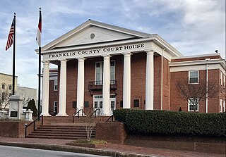
Franklin County is a county located in the U.S. state of North Carolina. As of the 2020 census, the population was 68,573. Its county seat is Louisburg.

<span class="mw-page-title-main">Chowan County, North Carolina</span> County in North Carolina, United States

Chowan County is one of the 100 counties located in the U.S. state of North Carolina. As of the 2020 census, the population was 13,708. Its county seat is Edenton. The county was created between 1668 and 1671 as Shaftesbury Precinct and later renamed Chowan Precinct. It gained county status in 1739.

<span class="mw-page-title-main">Bertie County, North Carolina</span> County in North Carolina, United States

Bertie County is a county located in the northeast area of the U.S. state of North Carolina. As of the 2020 census, the population was 17,934. Its county seat is Windsor. The county was created in 1722 as Bertie Precinct and gained county status in 1739.

<span class="mw-page-title-main">Ahoskie, North Carolina</span> Town in North Carolina, United States

Ahoskie is a town in Hertford County, North Carolina, United States. The population was 5,039 at the 2010 census. Ahoskie is located in North Carolina's Inner Banks region. Its nickname is "The Only One" because no other town in the world is known by the same name. The etymology of the word Ahoskie, which was originally spelled "Ahotsky", was from the Wyanoke Indians, who entered the Hertford County area at the beginning of European settlement.

<span class="mw-page-title-main">Como, North Carolina</span> Town in North Carolina, United States

Como is a town in Hertford County, North Carolina, United States. The population was 91 at the 2010 census.

<span class="mw-page-title-main">Murfreesboro, North Carolina</span> Town in North Carolina, United States

Murfreesboro is a town in Hertford County, North Carolina, United States. The population was 2,835 at the 2010 census. The town is home to Chowan University.

<span class="mw-page-title-main">Winton, North Carolina</span> Town in North Carolina, United States

Winton is a town and the county seat of Hertford County, North Carolina, United States. It is governed by the Town Council which consists of a Mayor and five Council members. The population was 769 at the 2010 census.

<span class="mw-page-title-main">Severn, North Carolina</span> Town in North Carolina, United States

Severn is a town in Northampton County, North Carolina, United States. The population was 276 at the 2010 census. It is part of the Roanoke Rapids, North Carolina Micropolitan Statistical Area. Severn is the home of Severn Peanut Corporation, the owners of the Hampton Farms brand of roasted peanuts.

<span class="mw-page-title-main">Meherrin</span> Indigenous people

The Meherrin people are an Indigenous people of the Northeastern Woodlands, who spoke an Iroquian language. They lived between the Piedmont and coastal plains at the border of Virginia and North Carolina.

<span class="mw-page-title-main">Chowan River</span>

The Chowan River (cho-WAHHN) is a blackwater river formed with the merging of Virginia's Blackwater and Nottoway rivers near the state line between Virginia and North Carolina. According to the USGS a variant name is Choan River.

<span class="mw-page-title-main">Inner Banks</span>

The Inner Banks is a neologism made up by developers and tourism promoters to describe the inland coastal region of eastern North Carolina. Without historical precedent, the term "Inner Banks" is an early 21st-century construct that is part of an attempt to rebrand the mostly agrarian coastal plain east of I-95 as a more attractive region for visitors and retirees.

<span class="mw-page-title-main">Meherrin River</span> Stream in Virginia, US

The Meherrin River is a 143.37 mi (230.73 km) long 6th order tributary to the Chowan River that joins in Hertford County, North Carolina.

<span class="mw-page-title-main">Parker's Ferry</span>

Parker's Ferry is a cable ferry located on the Meherrin River in Hertford County, North Carolina. The ferry is operated by a contractor for the North Carolina Department of Transportation.

<span class="mw-page-title-main">Chowanoc</span> Historical Native American tribe in North Carolina

The Chowanoc, also Chowanoke, are an Algonquian-speaking Native American tribe who historically lived near the Chowan River in North Carolina.

Hertford County Public Schools is a PK–12 graded school district serving Hertford County, North Carolina. The accredited district is led by superintendent Dr. Jesse Pratt and has a five-member board of education. Its seven schools serve 2,500 students as of the 2021–22 school year.

<span class="mw-page-title-main">Meherrin Indian Tribe</span> State-recognized tribe in North Carolina, United States

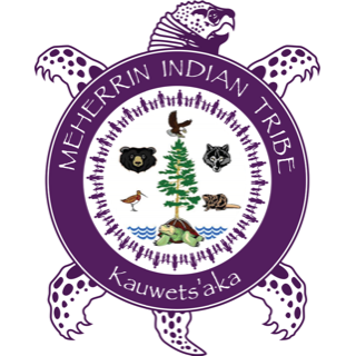
The Meherrin Indian Tribe is a state-recognized tribe and nonprofit organization in North Carolina. Its members identify as descendants of the Meherrin people. This group is not federally recognized as a Native American tribe.

References

  1. 1 2 3 "QuickFacts: Hertford County, North Carolina". United States Census Bureau. Retrieved March 21, 2024.
  2. "Find a County". National Association of Counties. Archived from the original on May 31, 2011. Retrieved June 7, 2011.
  3. 1 2 Brenda Linton and Leslie S. Stewart, Economic Development Assessment for the Meherrin Tribe, University of North Carolina, Jul 2003, accessed 26 Oct 2009
  4. Gannett, Henry (1905). The Origin of Certain Place Names in the United States. Govt. Print. Off. pp.  155.
  5. "2020 County Gazetteer Files – North Carolina". United States Census Bureau. August 23, 2022. Retrieved September 9, 2023.
  6. "NCWRC Game Lands". ncpaws.org. Retrieved March 30, 2023.
  7. "U.S. Decennial Census". United States Census Bureau. Retrieved January 17, 2015.
  8. "Historical Census Browser". University of Virginia Library. Retrieved January 17, 2015.
  9. Forstall, Richard L., ed. (March 27, 1995). "Population of Counties by Decennial Census: 1900 to 1990". United States Census Bureau. Retrieved January 17, 2015.
  10. "Census 2000 PHC-T-4. Ranking Tables for Counties: 1990 and 2000" (PDF). United States Census Bureau. April 2, 2001. Archived (PDF) from the original on March 27, 2010. Retrieved January 17, 2015.
  11. "State & County QuickFacts". United States Census Bureau. Archived from the original on June 7, 2011. Retrieved October 21, 2013.
  12. "Explore Census Data". data.census.gov. Retrieved December 24, 2021.
  13. "U.S. Census website". United States Census Bureau . Retrieved January 31, 2008.
  14. Gong, Phillip Joonbae (October 26, 2022). "Who are North Carolina's Registered Democrats? A 2022 update". Carolina Demography. University of North Carolina at Chapel Hill. Retrieved December 18, 2022.
  15. Pierre, Robert E. "N.C. Prison Doesn't Serve D.C. Inmates Well, Critics Say". Washington Post . October 14, 2007. p. 1" (Archive). Retrieved on February 5, 2016.
  16. Leip, David. "Dave Leip's Atlas of U.S. Presidential Elections". uselectionatlas.org. Retrieved March 15, 2018.
  17. "Hertford County Schools". North Carolina's School Report Cards. North Carolina Department of Public Instruction. Retrieved February 14, 2013.
  18. Taylor, Holly (September 13, 2022). "Local "report cards" show mixed results". The Roanoke-Chowan Herald. Retrieved January 3, 2023.