Durham County, North Carolina

Last updated

Durham County
Durham County Justice.JPG
Durham County Flag.gif
Durham County Seal.png
DCO Shield Color.png
Motto: 
"Live. Grow. Thrive."
Map of North Carolina highlighting Durham County.svg
Location within the U.S. state of North Carolina
North Carolina in United States.svg
North Carolina's location within the U.S.
Coordinates: 36°02′N78°53′W / 36.03°N 78.88°W / 36.03; -78.88
CountryFlag of the United States.svg United States
StateFlag of North Carolina.svg  North Carolina
Founded1881
Named for Bartlett Snipes Durham
Seat Durham
Largest communityDurham
Area
  Total297.86 sq mi (771.5 km2)
  Land286.53 sq mi (742.1 km2)
  Water11.33 sq mi (29.3 km2)  3.80%
Population
 (2020)
  Total324,833
  Estimate 
(2023)
336,892
  Density1,133.68/sq mi (437.72/km2)
Time zone UTC−5 (Eastern)
  Summer (DST) UTC−4 (EDT)
Congressional district 4th
Website www.dconc.gov

Durham County is a county located in the U.S. state of North Carolina. As of the 2020 census, the population was 324,833, [1] making it the sixth-most populous county in North Carolina. Its county seat is Durham, [2] which is the only incorporated municipality predominantly in the county, though very small portions of cities and towns mostly in neighboring counties also extend into Durham County. The central and southern parts of Durham County are highly urban, consisting of the city as well as several unincorporated suburbs. Southeastern Durham County is dominated by the Research Triangle Park, most of which is in Durham County. The northern third of Durham County is rural in nature.

Contents

Durham County is the core of the Durham-Chapel Hill, NC Metropolitan Statistical Area, which is also included in the Raleigh-Durham-Cary, NC Combined Statistical Area, which had an estimated population of 2,368,947 in 2023. [3]

History

The county was formed on April 17, 1881, from parts of Orange County and Wake County, taking the name of its own county seat. In 1911, parts of Cedar Fork Township of Wake County were transferred to Durham County and became Carr Township.

Geography

Durham County, North Carolina
Interactive map of Durham County

According to the U.S. Census Bureau, the county has a total area of 297.86 square miles (771.5 km2), of which 286.53 square miles (742.1 km2) is land and 11.33 square miles (29.3 km2) (3.80%) is water. [4]

State and local protected areas/sites

Major water bodies

Adjacent counties

Major highways

Major infrastructure

Demographics

Historical population
CensusPop.Note
1890 18,041
1900 26,23345.4%
1910 35,27634.5%
1920 42,21919.7%
1930 67,19659.2%
1940 80,24419.4%
1950 101,63926.7%
1960 111,99510.2%
1970 132,68118.5%
1980 152,78515.2%
1990 181,83519.0%
2000 223,31422.8%
2010 267,58719.8%
2020 324,83321.4%
2023 (est.)336,892 [1] 3.7%
U.S. Decennial Census [11]
1790–1960 [12] 1900–1990 [13]
1990–2000 [14] 2010–2020 [1]

2020 census

Durham County racial composition [15]
RaceNumberPercentage
White (non-Hispanic)133,76841.18%
Black or African American (non-Hispanic)109,22533.62%
Native American 7040.22%
Asian 16,7075.14%
Pacific Islander 830.03%
Other/Mixed 14,2424.38%
Hispanic or Latino 50,10415.42%

As of the 2020 census, there were 324,833 people, 131,140 households, and 75,291 families residing in the county.

2000 census

At the 2000 census, [16] there were 223,314 people, 89,015 households, and 54,032 families residing in the county. The population density was 769 people per square mile (297 people/km2). There were 95,452 housing units at an average density of 329 units per square mile (127 units/km2). The racial makeup of the county was 50.91% White, 39.46% Black or African American, 0.30% Native American, 3.29% Asian, 0.04% Pacific Islander, 4.21% from other races, and 1.80% from two or more races. 7.63% of the population were Hispanic or Latino of any race.

There were 89,015 households, out of which 29.10% had children under the age of 18 living with them, 42.00% were married couples living together, 14.80% had a female householder with no husband present, and 39.30% were non-families. 30.00% of all households were made up of individuals, and 7.00% had someone living alone who was 65 years of age or older. The average household size was 2.40 and the average family size was 2.99.

In the county, the age distribution was as follows: 22.90% under the age of 18, 12.80% from 18 to 24, 34.80% from 25 to 44, 19.80% from 45 to 64, and 9.70% who were 65 years of age or older. The median age was 32 years. For every 100 females there were 93.00 males. For every 100 females age 18 and over, there were 89.70 males.

The median income for a household in the county was $43,337, and the median income for a family was $53,223. Males had a median income of $35,939 versus $30,683 for females. The per capita income for the county was $23,156. About 9.80% of families and 13.40% of the population were below the poverty line, including 17.20% of those under age 18 and 12.30% of those age 65 or over.

Law and government

Durham County Sheriff's Office
AbbreviationDCSO, DSO
Motto"Honor, Duty and Service."
Agency overview
FormedMay 2, 1881
Employees452
Annual budget$34,949,195
Jurisdictional structure
Operations jurisdictionDurham County, North Carolina, US
General nature
Operational structure
Headquarters510 S Dillard St, Durham
Sworn officers
  • 181 Deputies [17]
  • 211 Detention Officers [17]
Civilians59 [17]
Agency executive
  • Clarence Birkhead, Sheriff
Facilities
Sub-Stations2
Notables
Award
Website
Official website

Durham County is a member of the regional Triangle J Council of Governments. Durham County is governed by a five-member board of county commissioners, currently consisting of Chair Brenda A. Howerton, Vice Chair Wendy Jacobs, Nimasheena Burns, Heidi Carter, and Nida Allam. [18] All are elected concurrently, and each elected member serves a four-year term. The current sheriff, Clarence Birkhead, was elected in 2018 and is the county's first African American Sheriff to hold office. [19]

Politics

Durham County is consistently one of the most Democratic counties in North Carolina, favoring Democrats in national, state, and local elections. [20] having only voted for the Republican candidate twice since 1884, the Republican landslides of 1928 and 1972. George H. W. Bush is the last Republican to manage even 40 percent of the county's vote. Since the 1990s, Durham County has been one of the most Democratic urban counties in the South.

United States presidential election results for Durham County, North Carolina [21]
Year Republican Democratic Third party
No.%No.%No.%
2020 32,45918.04%144,68880.42%2,7671.54%
2016 28,35018.16%121,25077.66%6,5344.18%
2012 33,76923.01%111,22475.80%1,7421.19%
2008 32,35323.63%103,45675.57%1,0880.79%
2004 34,61431.57%74,52467.96%5130.47%
2000 30,15035.64%53,90763.72%5470.65%
1996 27,82534.39%49,18660.79%3,8994.82%
1992 27,58133.36%47,33157.24%7,7709.40%
1988 29,92845.43%35,44153.79%5140.78%
1984 29,18547.39%32,24452.36%1550.25%
1980 19,27640.24%24,96952.13%3,6567.63%
1976 18,94545.61%22,42553.99%1630.39%
1972 25,57661.38%15,56637.36%5251.26%
1968 12,70529.68%16,56338.69%13,54231.63%
1964 15,26440.02%22,87459.98%00.00%
1960 14,32242.60%19,29857.40%00.00%
1956 13,22648.87%13,83551.13%00.00%
1952 11,30137.42%18,89762.58%00.00%
1948 4,53125.73%11,53065.46%1,5528.81%
1944 3,69022.43%12,76377.57%00.00%
1940 2,49114.40%14,81085.60%00.00%
1936 2,18914.60%12,80485.40%00.00%
1932 2,77025.94%7,55970.78%3513.29%
1928 8,72366.06%4,48233.94%00.00%
1924 3,09337.95%4,83759.34%2212.71%
1920 3,55043.31%4,64656.69%00.00%
1916 1,83742.72%2,46357.28%00.00%
1912 1243.52%2,19762.31%1,20534.17%
1908 1,82049.35%1,85950.41%90.24%
1904 1,08040.10%1,60359.52%100.37%
1900 2,02645.86%2,37353.71%190.43%
1896 1,92443.62%2,43555.20%521.18%
1892 1,26435.93%1,49042.35%76421.72%
1888 1,61845.77%1,83551.91%822.32%
1884 1,19342.79%1,59557.21%00.00%

Communities

Map of Durham County with municipal and township labels Map of Durham County North Carolina With Municipal and Township Labels.PNG
Map of Durham County with municipal and township labels

The city of Durham is the only incorporated municipality to predominantly exist within Durham County, and the only one whose urban core lies within the county, though small portions of municipalities from neighboring counties extend into Durham County, and the city of Durham also itself extends slightly into neighboring counties. All other towns and places within Durham County are unincorporated communities.

Cities

Towns

Townships

Census-designated places

Unincorporated communities

Notable person

See also

Related Research Articles

<span class="mw-page-title-main">Raleigh, North Carolina</span> Capital city of North Carolina, United States

Raleigh is the capital city of the U.S. state of North Carolina and the seat of Wake County. It is the second-most populous city in North Carolina, after Charlotte. Raleigh is the tenth-most populous city in the Southeast, the 41st-most populous city in the U.S., and the largest city of the Research Triangle metro area. Raleigh is known as the "City of Oaks" for its many oak trees, which line the streets in the heart of the city. The city covers a land area of 148.54 square miles (384.7 km2). The U.S. Census Bureau counted the city's population as 467,665 at the 2020 census. It is one of the fastest-growing cities in the United States. The city of Raleigh is named after Sir Walter Raleigh, who established the now-lost Roanoke Colony in present-day Dare County.

<span class="mw-page-title-main">Wake County, North Carolina</span> County in North Carolina, United States

Wake County is located in the U.S. state of North Carolina. As of the 2020 census, its population was 1,129,410, making it North Carolina's most populous county. From July 2005 to July 2006, Wake County was the 9th-fastest growing county in the United States, with Cary and Raleigh being the 8th- and 15th-fastest growing communities, respectively.

<span class="mw-page-title-main">Person County, North Carolina</span> County in North Carolina, United States

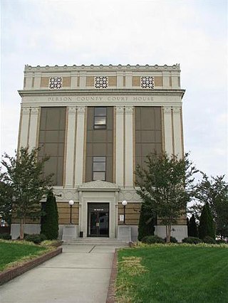
Person County is a county located in the U.S. state of North Carolina. The population was 39,097 as of the 2020 census. The county seat is Roxboro.

<span class="mw-page-title-main">Pamlico County, North Carolina</span> County in North Carolina, United States

PamlicoCounty is a county located in the U.S. state of North Carolina. As of the 2020 census, the population was 12,276. Its county seat is Bayboro.

<span class="mw-page-title-main">Orange County, North Carolina</span> County in North Carolina, United States

Orange County is a county located in the Piedmont region of the U.S. state of North Carolina. As of the 2020 census, the population was 148,696. Its county seat is Hillsborough.

<span class="mw-page-title-main">Onslow County, North Carolina</span> County in North Carolina, United States

Onslow County is a county located in the U.S. state of North Carolina. As of the 2020 census, the population was 204,576. Its county seat is Jacksonville. The county was created in 1734 as Onslow Precinct and gained county status in 1739. Onslow County comprises the Jacksonville, NC Metropolitan Statistical Area. The southern border is the coast of the Atlantic Ocean.

<span class="mw-page-title-main">Nash County, North Carolina</span> County in North Carolina, United States

Nash County is a county located in the U.S. state of North Carolina. As of the 2020 census, the population was 94,970. Its county seat is Nashville.

<span class="mw-page-title-main">Lee County, North Carolina</span> County in North Carolina, United States

Lee County is a county located in the U.S. state of North Carolina. As of the 2020 census, the population was 63,285. The county seat is Sanford.

<span class="mw-page-title-main">Johnston County, North Carolina</span> County in North Carolina, United States

Johnston County is a county located in the U.S. state of North Carolina. As of the 2020 census, the population was 215,999. Its county seat is Smithfield.

<span class="mw-page-title-main">Franklin County, North Carolina</span> County in North Carolina, United States

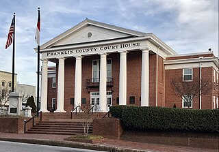
Franklin County is a county located in the U.S. state of North Carolina. As of the 2020 census, the population was 68,573. Its county seat is Louisburg.

<span class="mw-page-title-main">Chatham County, North Carolina</span> County in North Carolina, United States

Chatham County is a county located in the Piedmont area of the U.S. state of North Carolina. It is also the location of the geographic center of North Carolina, northwest of Sanford. As of the 2020 census, the population was 76,285. Its county seat is Pittsboro.

<span class="mw-page-title-main">Beaufort County, North Carolina</span> County in North Carolina, United States

Beaufort County is a county located in the U.S. state of North Carolina. As of the 2020 census, the population was 44,652. Its county seat is Washington. The county was founded in 1705 as Pamptecough Precinct. Originally included in Bath County, it was renamed Beaufort Precinct in 1712 and became Beaufort County in 1739.

<span class="mw-page-title-main">Erwin, North Carolina</span> Town in North Carolina, United States. Mayor of Erwin is Kayleigh Hensley

Erwin is a town that is located in the eastern part of Harnett County, North Carolina, United States, located approximately 5 miles (8.0 km) from Dunn and approximately 20 miles (32 km) from Fayetteville. The city is a part of the Dunn, NC Micropolitan Statistical Area, which is additionally a part of the greater Raleigh-Durham-Cary, NC CSA, according to the United States Census Bureau. Currently, the city has a population of 5,270 as of the 2020 census. Its current mayor is Randy Baker, who has been the mayor since being elected on May 17, 2022.

<span class="mw-page-title-main">Hillsborough, North Carolina</span> Town in North Carolina, United States

The town of Hillsborough is the county seat of Orange County, North Carolina, United States and is located along the Eno River. The population was 6,087 in 2010, but it grew rapidly to 9,660 by 2020.

<span class="mw-page-title-main">Roxboro, North Carolina</span> City in North Carolina, United States

Roxboro is a city and the county seat of Person County in the U.S. state of North Carolina. The population was 8,134 at the 2020 census. The city is 30 miles (48 km) north of Durham and is a part of the four-county Durham–Chapel Hill Metropolitan Statistical Area, which has a population of 649,903 as of the 2020 Census. The Durham–Chapel Hill MSA is a part of the larger Raleigh–Durham–Cary Combined Statistical Area, which has a population of 2,043,867 as of the 2020 Census.

<span class="mw-page-title-main">Apex, North Carolina</span> Town in North Carolina, United States

Apex is a town in Wake County, North Carolina, United States. At its southern border, Apex encompasses the community of Friendship. In 1994, the downtown area was designated a historic district, and the Apex train depot, built in 1867, is designated a Wake County landmark. The depot location marks the highest point on the old Chatham Railroad, hence the town's name. The town motto is "The Peak of Good Living".

<span class="mw-page-title-main">Garner, North Carolina</span> Town in North Carolina, United States

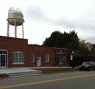
Garner is a town in Wake County, North Carolina, United States and a suburb of Raleigh. The population is 31,159 as of the 2020 census. The city limits are entirely within Wake County, though portions of unincorporated Wake County, as well as the Cleveland community in northern Johnston County, have Garner mailing addresses. It is part of the Research Triangle region of North Carolina and serves as a bedroom community for the region.

<span class="mw-page-title-main">Durham, North Carolina</span> City in North Carolina, United States

Durham is a city in the U.S. state of North Carolina and the county seat of Durham County. Small portions of the city limits extend into Orange County and Wake County. With a population of 283,506 in the 2020 census, Durham is the 4th-most populous city in North Carolina, and the 71st-most populous city in the United States. The city is located in the east-central part of the Piedmont region along the Eno River. Durham is the core of the four-county Durham-Chapel Hill, NC Metropolitan Statistical Area, which had an estimated population of 608,879 in 2023. The Office of Management and Budget also includes Durham as a part of the Raleigh-Durham-Cary, NC Combined Statistical Area, commonly known as the Research Triangle, which had an estimated population of 2,368,947 in 2023.

<span class="mw-page-title-main">Morrisville, North Carolina</span> Town in North Carolina, United States

Morrisville is a town located primarily in Wake County, North Carolina, United States. According to the 2020 census, the population was 29,630. Morrisville is part of the Research Triangle metropolitan region. The regional name originated after the 1959 creation of the Research Triangle Park, located midway between the cities of Raleigh and Durham. The Research Triangle region encompasses the Raleigh-Durham-Cary, NC Combined Statistical Area. The population of the Raleigh-Durham-Cary, NC Combined Statistical Area was 2,106,463 in 2020, while the population of the Raleigh-Cary, NC Metropolitan Statistical Area was 1,413,982 in 2020. The operational headquarters of Lenovo is located in the municipal limits.

<span class="mw-page-title-main">Research Triangle</span> Geographic region of North Carolina, U.S.

The Research Triangle, or simply The Triangle, are both common nicknames for a metropolitan area in the Piedmont region of the U.S. state of North Carolina. Anchored by the cities of Raleigh and Durham and the town of Chapel Hill, the region is home to three major research universities: North Carolina State University, Duke University, and the University of North Carolina at Chapel Hill, respectively. The "Triangle" name originated in the 1950s with the creation of Research Triangle Park located between the three anchor cities, which is the largest research park in the United States and home to numerous high tech companies.

References

  1. 1 2 3 "QuickFacts: Durham County, North Carolina". United States Census Bureau. Retrieved March 21, 2024.
  2. "Find a County". National Association of Counties. Archived from the original on July 12, 2012. Retrieved June 7, 2011.
  3. "Metropolitan and Micropolitan Statistical Areas Population Totals: 2020-2023". United States Census Bureau, Population Division. March 14, 2024. Retrieved March 15, 2024.
  4. "2020 County Gazetteer Files – North Carolina". United States Census Bureau. August 23, 2022. Retrieved September 9, 2023.
  5. 1 2 "NCWRC Game Lands". www.ncpaws.org. Retrieved March 30, 2023.
  6. "Hollow Rock Nature Park". Orange County, NC. Retrieved July 27, 2022.
  7. "Miles of Trails with More in the Making - Triangle Land Conservancy". www.triangleland.org. December 11, 2015. Retrieved July 27, 2022.
  8. "Little River Regional Park & Natural Area". Eno River Association - Education, Advocacy & Conservation. Retrieved July 27, 2022.
  9. "Mason Farm Biological Reserve - North Carolina Botanical Garden" . Retrieved July 27, 2022.
  10. "Rollingview at Falls Lake Durham, NC". www.visitnc.com. Retrieved July 27, 2022.
  11. "U.S. Decennial Census". United States Census Bureau. Archived from the original on July 1, 2021. Retrieved January 14, 2015.
  12. "Historical Census Browser". University of Virginia Library. Archived from the original on August 11, 2012. Retrieved January 14, 2015.
  13. Forstall, Richard L., ed. (March 27, 1995). "Population of Counties by Decennial Census: 1900 to 1990". United States Census Bureau. Archived from the original on March 3, 2015. Retrieved January 14, 2015.
  14. "Census 2000 PHC-T-4. Ranking Tables for Counties: 1990 and 2000" (PDF). United States Census Bureau. April 2, 2001. Archived (PDF) from the original on December 18, 2014. Retrieved January 14, 2015.
  15. "Explore Census Data". data.census.gov. Archived from the original on April 12, 2022. Retrieved December 20, 2021.
  16. "U.S. Census website". United States Census Bureau. Archived from the original on July 9, 2021. Retrieved January 31, 2008.
  17. 1 2 3 "Annual Report FY 2016-2017". Durham Sheriff. 2017. Archived from the original on January 8, 2020. Retrieved April 12, 2022.
  18. "Contact the Board of Commissioners | Durham County". www.dconc.gov. Archived from the original on March 28, 2022. Retrieved April 12, 2022.
  19. Simmons, Taj (December 3, 2018). "New Durham County Sheriff Takes Oath of Office". spectrumlocalnews.com. Archived from the original on April 19, 2019. Retrieved April 12, 2022.
  20. "Anatomy of a swing state: What these 6 counties tell us about the upcoming NC election". The Charlotte Observer. November 4, 2022. Retrieved November 4, 2022.
  21. Leip, David. "Dave Leip's Atlas of U.S. Presidential Elections". uselectionatlas.org. Archived from the original on March 23, 2018. Retrieved March 15, 2018.
  22. Raleigh Durham Annexation Agreement Lines Archived October 19, 2011, at the Wayback Machine
  23. "Federal Writers Project Papers".