Pender County | |
---|---|
Motto: "Find Your Treasure" | |
Coordinates: 34°31′N77°53′W / 34.51°N 77.89°W | |
Country | United States |
State | North Carolina |
Founded | 1875 |
Named for | William Dorsey Pender |
Seat | Burgaw |
Largest community | Hampstead |
Area | |
• Total | 934.17 sq mi (2,419.5 km2) |
• Land | 871.30 sq mi (2,256.7 km2) |
• Water | 62.87 sq mi (162.8 km2) 6.73% |
Population (2020) | |
• Total | 60,203 |
• Estimate (2023) | 68,521 |
• Density | 69.10/sq mi (26.68/km2) |
Time zone | UTC−5 (Eastern) |
• Summer (DST) | UTC−4 (EDT) |
Congressional district | 7th |
Website | www |
Pender County is a county located in the U.S. state of North Carolina. As of the 2020 census, the population was 60,203. [1] Its county seat is Burgaw. [2] Pender County is part of the Wilmington, NC Metropolitan Statistical Area.
The county was formed in 1875 from New Hanover County. It was named for William Dorsey Pender of Edgecombe County, a Confederate general mortally wounded at the Battle of Gettysburg. [3] It is in the southeastern section of the state and is bounded by the Atlantic Ocean and New Hanover, Brunswick, Columbus, Bladen, Sampson, Duplin, and Onslow counties. The present land area is 870.76 square miles (2,255.3 km2) and the 2010 population was 52,196, which has nearly doubled since 1990. The estimated county population in 2019 had increased to 63,060. [1] The county commissioners were ordered to hold their first meeting at Rocky Point. The act provided for the establishment of the town of Cowan as the county seat. In 1877, an act was passed repealing that section of the law relative to the town, and another law was enacted, whereby the qualified voters were to vote on the question of moving the county seat to South Washington or any other place which the majority of the voters designated. Whatever place was selected, the town should be called Stanford. In 1879, Stanford was changed to Burgaw, which was by that law incorporated. It is the county seat. A slave cemetery that was used by the community of Cardinal Acres up until c. 1950 was disturbed by a developer grading a site in 2021. [4]
According to the U.S. Census Bureau, the county has a total area of 934.17 square miles (2,419.5 km2), of which 871.30 square miles (2,256.7 km2) is land and 62.87 square miles (162.8 km2) (6.73%) is water. [5] It is the fifth-largest county in North Carolina by land area.
Census | Pop. | Note | %± |
---|---|---|---|
1880 | 12,468 | — | |
1890 | 12,514 | 0.4% | |
1900 | 13,381 | 6.9% | |
1910 | 15,471 | 15.6% | |
1920 | 14,788 | −4.4% | |
1930 | 15,686 | 6.1% | |
1940 | 17,710 | 12.9% | |
1950 | 18,423 | 4.0% | |
1960 | 18,508 | 0.5% | |
1970 | 18,149 | −1.9% | |
1980 | 22,215 | 22.4% | |
1990 | 28,855 | 29.9% | |
2000 | 41,082 | 42.4% | |
2010 | 52,217 | 27.1% | |
2020 | 60,203 | 15.3% | |
2023 (est.) | 68,521 | [1] | 13.8% |
U.S. Decennial Census [9] 1790–1960 [10] 1900–1990 [11] 1990–2000 [12] 2010 [13] 2020 [1] |
Race | Number | Percentage |
---|---|---|
White (non-Hispanic) | 44,418 | 73.78% |
Black or African American (non-Hispanic) | 7,544 | 12.53% |
Native American | 195 | 0.32% |
Asian | 319 | 0.53% |
Pacific Islander | 23 | 0.04% |
Other/Mixed | 2,722 | 4.52% |
Hispanic or Latino | 4,982 | 8.28% |
As of the 2020 census, there were 60,203 people, 21,740 households, and 14,676 families residing in the county.
At the 2000 census, [15] there were 41,082 people, 16,054 households, and 11,719 families residing in the county. The population density was 47 people per square mile (18 people/km2). There were 20,798 housing units at an average density of 24 units per square mile (9.3 units/km2). The racial makeup of the county was 72.74% White, 23.58% Black or African American, 0.49% Native American, 0.18% Asian, 0.03% Pacific Islander, 2.03% from other races, and 0.94% from two or more races. 3.64% of the population were Hispanic or Latino of any race.
There were 16,054 households, out of which 29.40% had children under the age of 18 living with them, 57.90% were married couples living together, 11.20% had a female householder with no husband present, and 27.00% were non-families. 22.90% of all households were made up of individuals, and 8.50% had someone living alone who was 65 years of age or older. The average household size was 2.49 and the average family size was 2.90.
In the county, the population was spread out, with 23.20% under the age of 18, 7.40% from 18 to 24, 29.50% from 25 to 44, 25.80% from 45 to 64, and 14.10% who were 65 years of age or older. The median age was 39 years. For every 100 females there were 101.20 males. For every 100 females age 18 and over, there were 99.50 males.
The median income for a household in the county was $35,902, and the median income for a family was $41,633. Males had a median income of $31,424 versus $21,623 for females. The per capita income for the county was $17,882. About 9.50% of families and 13.60% of the population were below the poverty line, including 18.60% of those under age 18 and 14.40% of those age 65 or over.
Pender County is a member of the regional Cape Fear Council of Governments.
The government is run by a board of commissioners with a county manager.
Pender County is a strong Republican county, voting with the party since 1996. In the 1992 U.S. presidential election, Democratic nominee Bill Clinton won the county. In the 2016 U.S. presidential election, Republican nominee Donald Trump won the county with 63.3% of the vote, over Democratic nominee Hillary Clinton's 33.5%.
Year | Republican | Democratic | Third party | |||
---|---|---|---|---|---|---|
No. | % | No. | % | No. | % | |
2020 | 21,956 | 64.26% | 11,723 | 34.31% | 490 | 1.43% |
2016 | 17,639 | 63.26% | 9,354 | 33.54% | 892 | 3.20% |
2012 | 14,617 | 59.60% | 9,632 | 39.27% | 278 | 1.13% |
2008 | 13,618 | 57.34% | 9,907 | 41.72% | 224 | 0.94% |
2004 | 10,037 | 58.75% | 6,999 | 40.97% | 49 | 0.29% |
2000 | 7,661 | 54.13% | 6,415 | 45.32% | 78 | 0.55% |
1996 | 5,538 | 46.38% | 5,409 | 45.30% | 993 | 8.32% |
1992 | 4,857 | 39.07% | 5,825 | 46.86% | 1,748 | 14.06% |
1988 | 4,926 | 52.84% | 4,377 | 46.95% | 20 | 0.21% |
1984 | 5,079 | 53.73% | 4,354 | 46.06% | 20 | 0.21% |
1980 | 3,018 | 40.05% | 4,382 | 58.15% | 136 | 1.80% |
1976 | 2,063 | 31.56% | 4,422 | 67.65% | 52 | 0.80% |
1972 | 3,327 | 68.90% | 1,415 | 29.30% | 87 | 1.80% |
1968 | 1,007 | 17.76% | 1,942 | 34.26% | 2,720 | 47.98% |
1964 | 1,961 | 37.96% | 3,205 | 62.04% | 0 | 0.00% |
1960 | 1,274 | 31.71% | 2,744 | 68.29% | 0 | 0.00% |
1956 | 1,009 | 31.48% | 2,196 | 68.52% | 0 | 0.00% |
1952 | 1,152 | 36.22% | 2,029 | 63.78% | 0 | 0.00% |
1948 | 304 | 14.22% | 1,334 | 62.39% | 500 | 23.39% |
1944 | 441 | 20.29% | 1,732 | 79.71% | 0 | 0.00% |
1940 | 305 | 11.94% | 2,249 | 88.06% | 0 | 0.00% |
1936 | 333 | 12.28% | 2,379 | 87.72% | 0 | 0.00% |
1932 | 270 | 11.87% | 1,993 | 87.64% | 11 | 0.48% |
1928 | 1,300 | 56.57% | 998 | 43.43% | 0 | 0.00% |
1924 | 253 | 17.51% | 1,175 | 81.31% | 17 | 1.18% |
1920 | 699 | 30.67% | 1,580 | 69.33% | 0 | 0.00% |
1916 | 400 | 29.20% | 970 | 70.80% | 0 | 0.00% |
1912 | 19 | 1.52% | 967 | 77.11% | 268 | 21.37% |
The county is served by Pender County Schools.
Montgomery County is a rural county located in the southern Piedmont of the U.S. state of North Carolina. As of the 2020 census, the population was 25,751. Its county seat is Troy.
Yancey County is a county located in the U.S. state of North Carolina. As of the 2020 census, the population was 18,470. Its county seat is Burnsville.
Wilson County is a county located in the U.S. state of North Carolina. As of the 2020 census, the population was 78,784. The county seat is Wilson. The county comprises the Wilson, NC Micropolitan Statistical Area, which is also included within the Rocky Mount-Wilson-Roanoke Rapids, NC Combined Statistical Area.
Union County is a county located in the U.S. state of North Carolina. As of the 2020 census, the population was 238,267. Its county seat is Monroe. Union County is included in the Charlotte-Concord-Gastonia, NC-SC Metropolitan Statistical Area.
Stanly County is a county in the U.S. state of North Carolina. As of the 2020 census, the population was 62,504. Its county seat is Albemarle.
Sampson County is a county located in the U.S. state of North Carolina. As of the 2020 census, the population was 59,036. Its county seat is Clinton.
Onslow County is a county located in the U.S. state of North Carolina. As of the 2020 census, the population was 204,576. Its county seat is Jacksonville. The county was created in 1734 as Onslow Precinct and gained county status in 1739. Onslow County comprises the Jacksonville, NC Metropolitan Statistical Area. The southern border is the coast of the Atlantic Ocean.
New Hanover County is a county located in the U.S. state of North Carolina. As of the 2020 census, the population was 225,702. Though the second-smallest county in North Carolina by land area, it is one of the most populous, as its county seat, Wilmington, is one of the state's largest communities. The county was created in 1729 as New Hanover Precinct and gained county status in 1739. New Hanover County is included in the Wilmington, NC Metropolitan Statistical Area, which also includes neighboring Pender and Brunswick counties.
Nash County is a county located in the U.S. state of North Carolina. As of the 2020 census, the population was 94,970. Its county seat is Nashville.
Jones County is a county located in the U.S. state of North Carolina. As of the 2020 census, the population was 9,172, making it the fourth-least populous county in North Carolina. Its county seat is Trenton. Jones County is part of the New Bern, NC Micropolitan Statistical Area.
Edgecombe County is a county located in the U.S. state of North Carolina. As of the 2020 census, the population was 48,900. Its county seat is Tarboro.
Duplin County is a county located in the U.S. state of North Carolina. As of the 2020 census, the population was 48,715. Its county seat is Kenansville.
Cumberland County is a county located in the U.S. state of North Carolina. As of the 2020 census, the population was 334,728, making it the fifth-most populous county in North Carolina. Its county seat is Fayetteville. Cumberland County is part of the Fayetteville, NC Metropolitan Statistical Area.
Caldwell County is a county in the U.S. state of North Carolina. It is located in the foothills of the Blue Ridge Mountains. As of the 2020 census, the population was 80,652. Its county seat is Lenoir. Caldwell County is part of the Hickory-Lenoir-Morganton, NC Metropolitan Statistical Area.
Brunswick County is a county located in the U.S. state of North Carolina. It is the southernmost county in the state. As of the 2020 census, the population was 136,693. Its population was only 73,143 in 2000, making it one of the fastest-growing counties in the state. With a nominal growth rate of approximately 47% in ten years, much of the growth is centered in the eastern section of the county in the suburbs of Wilmington such as Leland, Belville and Southport. The county seat is Bolivia, which at a population of around 150 people is among the least populous county seats in the state.
Bladen County is a county located in the U.S. state of North Carolina. As of the 2020 census, the population was 29,606. Its county seat is Elizabethtown. The county was created in 1734 as Bladen Precinct and gained county status in 1739.
Ashe County is a county located in the U.S. state of North Carolina. As of the 2020 census, the population was 26,577. Its county seat is Jefferson.
Burgaw is a town in, and the county seat of, Pender County, North Carolina, United States. The population was 3,088 at the 2020 census.
Wallace is a town in Duplin and Pender counties in the U.S. state of North Carolina. The population was 3,883 at the 2020 census.
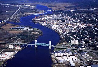
Cape Fear is a coastal plain and Tidewater region of North Carolina centered about the city of Wilmington. The region takes its name from the adjacent Cape Fear headland, as does the Cape Fear River which flows through the region and empties into the Atlantic Ocean near the cape. Much of the region's populated areas are found along the Atlantic beaches and the Atlantic Intracoastal Waterway, while the rural areas are dominated by farms and swampland like that of the Green Swamp. The general area can be also identified by the titles "Lower Cape Fear", "Wilmington, NC Metropolitan Statistical Area", "Southeastern North Carolina", and "Azalea Coast". The latter name is derived from the North Carolina Azalea Festival held annually in Wilmington. Municipalities in the area belong to the Cape Fear Council of Governments.