Burgaw, North Carolina

Last updated

Burgaw, North Carolina
Burgaw, North Carolina.jpg
South Wright Street
Burgaw, NC Town Seal.jpg
Motto: 
"Good Town Year Round"
NCMap-doton-Burgaw.PNG
Location of Burgaw, North Carolina
Coordinates: 34°33′03″N77°55′21″W / 34.55083°N 77.92250°W / 34.55083; -77.92250
Country United States
State North Carolina
County Pender
Settled1850
Incorporated1879
Government
  MayorOlivia Dawson
Area
[1]
  Total4.75 sq mi (12.30 km2)
  Land4.74 sq mi (12.27 km2)
  Water0.01 sq mi (0.03 km2)
Elevation
[2]
43 ft (13 m)
Population
 (2020)
  Total3,088
  Density651.61/sq mi (251.58/km2)
Time zone UTC-5 (Eastern (EST))
  Summer (DST) UTC-4 (EDT)
ZIP code
28425
Area codes 910, 472
FIPS code 37-08960 [3]
GNIS feature ID2405345 [2]
Website townofburgaw.com

Burgaw is a town in, and the county seat of, Pender County, [4] North Carolina, United States. The population was 3,088 at the 2020 census.

Contents

Burgaw is part of the Wilmington, NC Metropolitan Statistical Area.

History

The town most likely derives its name from nearby Burgaw Creek. [5]

The Bannerman House, Burgaw Depot, Burgaw Historic District, and Pender County Courthouse are listed on the National Register of Historic Places. [6]

Geography

According to the United States Census Bureau, the town has a total area of 3.5 square miles (9.1 km2), of which 3.4 square miles (8.9 km2) is land and 0.29% is water.

Demographics

Historical population
CensusPop.Note
1880 184
1890 36698.9%
1900 3875.7%
1910 956147.0%
1920 1,0408.8%
1930 1,20916.3%
1940 1,47622.1%
1950 1,6139.3%
1960 1,7508.5%
1970 1,744−0.3%
1980 1,738−0.3%
1990 1,8074.0%
2000 3,33784.7%
2010 3,87216.0%
2020 3,088−20.2%
U.S. Decennial Census [7]

2020 census

Burgaw racial composition [8]
RaceNumberPercentage
White (non-Hispanic)1,79658.16%
Black or African American (non-Hispanic)89128.85%
Native American 110.36%
Asian 160.52%
Other/Mixed 1484.79%
Hispanic or Latino 2267.32%

As of the 2020 United States census, there were 3,088 people, 1,249 households, and 682 families residing in the town.

2000 census

As of the census [3] of 2000, there were 3,337 people, 954 households, and 649 families residing in the town. The population density was 971.6 inhabitants per square mile (375.1/km2). There were 1,051 housing units at an average density of 306.0 per square mile (118.1/km2). The racial makeup of the town was 51.21% White, 44.89% African American, 0.69% Native American, 0.12% Asian, 2.10% from other races, and 0.99% from two or more races. Hispanic or Latino of any race were 4.50% of the population.

There were 954 households, out of which 33.9% had children under the age of 18 living with them, 42.7% were married couples living together, 22.2% had a female householder with no husband present, and 31.9% were non-families. 28.6% of all households were made up of individuals, and 13.2% had someone living alone who was 65 years of age or older. The average household size was 2.39 and the average family size was 2.92.

In the town, the population was spread out, with 18.8% under the age of 18, 9.2% from 18 to 24, 34.0% from 25 to 44, 19.9% from 45 to 64, and 18.1% who were 65 years of age or older. The median age was 37 years. For every 100 females, there were 128.7 males. For every 100 females age 18 and over, there were 137.4 males.

The median income for a household in the town was $28,819, and the median income for a family was $36,813. Males had a median income of $29,750 versus $21,792 for females. The per capita income for the town was $13,831. About 13.0% of families and 19.3% of the population were below the poverty line, including 24.1% of those under age 18 and 20.2% of those age 65 or over.

Related Research Articles

<span class="mw-page-title-main">Pender County, North Carolina</span> County in North Carolina, United States

Pender County is a county located in the U.S. state of North Carolina. As of the 2020 census, the population was 60,203. Its county seat is Burgaw. Pender County is part of the Wilmington, NC Metropolitan Statistical Area.

<span class="mw-page-title-main">Gulf Stream, Florida</span> Town in the state of Florida, United States

Gulf Stream is a town in Palm Beach County, Florida, United States. It is part of the Miami metropolitan area of South Florida. The population of the town was at 954 as of the 2020 US Census.

<span class="mw-page-title-main">Medora, Indiana</span> Town in Indiana, United States

Medora is a town in Carr Township, Jackson County, Indiana, United States. The population was 693 at the 2010 census.

<span class="mw-page-title-main">Beloit, Kansas</span> City in Mitchell County, Kansas

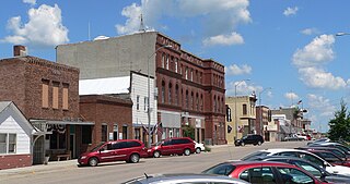
Beloit is a city in and the county seat of Mitchell County, Kansas, United States. As of the 2020 census, the population of the city was 3,404.

<span class="mw-page-title-main">Perham, Maine</span> Town in the state of Maine, United States

Perham is a town in Aroostook County, Maine, United States. The population was 371 at the 2020 census. The town was named after Maine's 33rd governor, Sidney Perham.

Stetson is a town in Penobscot County, Maine, United States. The population was 1,186 at the 2020 census. It was named after its first proprietor, Amasa Stetson. His brother Simeon Stetson originally settled here as well, but moved to nearby Hampden in 1803. Simeon's sons Charles, George, and Isaiah founded a powerful mercantile and political family in Bangor.

Beals is a town in Washington County, Maine, United States, located on an island opposite Jonesport. The town was named after Manwarren Beal, an early settler. The population was 443 at the 2020 census.

<span class="mw-page-title-main">Pender, Nebraska</span> Village in and county seat of Thurston County, Nebraska, United States

Pender is a village in and the county seat of Thurston County, Nebraska, United States. On March 22, 2016, the United States Supreme Court resolved a disagreement as to whether Pender is located on the Omaha Indian Reservation, holding unanimously that "the disputed land is within the reservation’s boundaries." The predominantly European-American population was 1,115 at the 2020 census.

<span class="mw-page-title-main">Atkinson, North Carolina</span> Town in North Carolina, United States

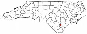
Atkinson is a town in Pender County, North Carolina, United States. At the 2010 census, the town population was 299. It is part of the Wilmington Metropolitan Statistical Area. The town was incorporated in 1989.

<span class="mw-page-title-main">Watha, North Carolina</span> Town in North Carolina, United States

Watha is a town in Pender County, North Carolina, United States. The population was 190 at the 2010 census. It is part of the Wilmington Metropolitan Statistical Area.

<span class="mw-page-title-main">Central High, Oklahoma</span> Town in Oklahoma, United States

Central High is a town in Stephens County, Oklahoma, United States. The population was 1,181 at the time of the 2020 Census.

<span class="mw-page-title-main">York Haven, Pennsylvania</span> Borough in Pennsylvania, United States

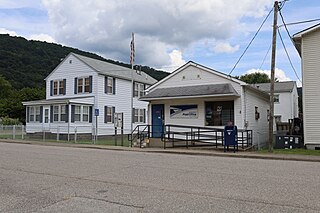
York Haven is a borough in York County, Pennsylvania, United States. The population was 691 at the 2020 census. It is part of the York–Hanover metropolitan area. The borough is the home of the Brunner Island coal-fired electrical generation plant, located on the Susquehanna River on Wago Road and operated by PPL Corporation.

<span class="mw-page-title-main">Lakeland North, Washington</span> Census-designated place in Washington, United States

Lakeland North is a census-designated place (CDP) in King County, Washington, United States. The population was 13,663 at the 2020 census. Part of the community was annexed into neighboring Auburn in 2008.

<span class="mw-page-title-main">Pratt, West Virginia</span> Town in West Virginia, United States

Pratt is a town in Kanawha County, West Virginia, United States, along the Kanawha River. The population was 482 at the 2020 census.

<span class="mw-page-title-main">Brandonville, West Virginia</span> Town in West Virginia, United States

Brandonville is a town in northern Preston County, West Virginia, United States. The population was 136 at the 2020 census. It is part of the Morgantown metropolitan area.

<span class="mw-page-title-main">Lester, West Virginia</span> Town in West Virginia, United States

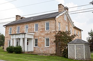
Lester is a town in Raleigh County, West Virginia, United States. The population was 337 at the 2020 census. The community was named after Champ Lester, a local pioneer.

<span class="mw-page-title-main">Mill Creek, West Virginia</span> Town in West Virginia, United States

Mill Creek is a town in Randolph County, West Virginia, United States, along the Tygart Valley River. The population was 563 at the 2020 census.

<span class="mw-page-title-main">Surf City, North Carolina</span> Town in North Carolina, United States

Surf City is a town in Onslow and Pender counties in the U.S. state of North Carolina. The population was 3,867 at the 2020 census. It is located on Topsail Island.

<span class="mw-page-title-main">St. Albans, Maine</span> Town in the state of Maine, United States

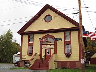
St. Albans is a town in Somerset County, Maine, United States. The population was 2,045 at the 2020 census.

<span class="mw-page-title-main">Falmouth (CDP), Massachusetts</span> Census-designated place in Massachusetts, United States

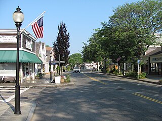
Falmouth is a census-designated place (CDP) consisting of the primary settlement in the town of Falmouth in Barnstable County, Massachusetts, United States. The population of the CDP was 3,799 at the 2010 census, out of 31,532 in the town as a whole. It was named after Falmouth, Cornwall, England.

References

  1. "ArcGIS REST Services Directory". United States Census Bureau. Retrieved September 20, 2022.
  2. 1 2 U.S. Geological Survey Geographic Names Information System: Burgaw, North Carolina
  3. 1 2 "U.S. Census website". United States Census Bureau . Retrieved January 31, 2008.
  4. "Find a County". National Association of Counties. Archived from the original on May 31, 2011. Retrieved June 7, 2011.
  5. Proffitt, Martie (April 17, 1983). "Local history offers tasty tidbits". Star-News. pp. 8C. Retrieved November 1, 2015.
  6. "National Register Information System". National Register of Historic Places . National Park Service. July 9, 2010.
  7. "Census of Population and Housing". Census.gov. Retrieved June 4, 2015.
  8. "Explore Census Data". data.census.gov. Retrieved December 24, 2021.