Wallace, North Carolina

Last updated

Wallace, North Carolina
Wallace, North Carolina 01.jpg
Wallace, NC Town Seal.png
Motto: 
"Pleasant...Progressive...Prosperous"
USA North Carolina location map.svg
Red pog.svg
Wallace
Location within the state of North Carolina
Coordinates: 34°44′16″N77°59′26″W / 34.73778°N 77.99056°W / 34.73778; -77.99056
CountryUnited States
State North Carolina
Counties Duplin, Pender
Area
[1]
  Total3.19 sq mi (8.27 km2)
  Land3.19 sq mi (8.27 km2)
  Water0.00 sq mi (0.00 km2)
Elevation
[2]
52 ft (16 m)
Population
 (2020)
  Total3,413
  Density1,068.57/sq mi (412.64/km2)
Time zone UTC−5 (Eastern (EST))
  Summer (DST) UTC−4 (EDT)
ZIP code
28466
Area codes 910, 472
FIPS code 37-70720 [3]
GNIS feature ID2406822 [2]
Website www.townofwallace.com

Wallace is a town in Duplin and Pender counties in the U.S. state of North Carolina. The population was 3,883 at the 2020 census. [4] The Pender County portion of Wallace is part of the Wilmington Metropolitan Statistical Area. The town of Wallace was first known as Duplin Crossroads and was incorporated into existence in 1873. Later in 1899, the town fathers decided to adopt the new name, Wallace, to honor Stephen D. Wallace, an official of the Atlantic Coast Line Railroad. Wallace is Duplin County's largest population and retail trade center serving over 50,000 people in a surrounding three county area. [5]

Contents

SouthPark, an industrial park, is open near I-40 in Wallace. Low tax rates are an incentive to industry and business considering the Wallace area.

The Wallace Airport, Henderson Field, serves to make Wallace more accessible. The airport offers a 4,000 foot paved and lighted runway with a navigational beacon.

History

The W. Stokes Boney House, Isaac M. Powers House, and Wallace Commercial Historic District are listed on the National Register of Historic Places. [6]

Geography

Wallace is located in southern Duplin County and the town limits extend south into Pender County.

U.S. Route 117 passes through the center of town, leading north 19 miles (31 km) to Warsaw and south 15 miles (24 km) to Burgaw. North Carolina Highway 41 crosses US 117 in the center of Wallace, and leads northeast 14 miles (23 km) to Chinquapin and west 14 miles (23 km) to Harrells. Interstate 40 passes east of Wallace, with access from Exit 390 (US 117 4 miles (6 km) south of town) and Exit 385 (NC 41 3 miles (5 km) east of town). I-40 leads south 44 miles (71 km) to Wilmington and north 89 miles (143 km) to Raleigh.

According to the United States Census Bureau, the town has a total area of 3.1 square miles (7.9 km2), all land. [7]

Demographics

Historical population
CensusPop.Note
1890 119
1900 21883.2%
1910 444103.7%
1920 64845.9%
1930 73413.3%
1940 1,05043.1%
1950 1,62254.5%
1960 2,28540.9%
1970 2,90527.1%
1980 2,903−0.1%
1990 2,9391.2%
2000 3,34413.8%
2010 3,88016.0%
2020 3,413−12.0%
U.S. Decennial Census [8]

2020 census

Wallace racial composition [9]
RaceNumberPercentage
White (non-Hispanic)1,42641.78%
Black or African American (non-Hispanic)83524.47%
Native American 200.59%
Asian 140.41%
Other/Mixed 762.23%
Hispanic or Latino 1,04230.53%

As of the 2020 United States census, there were 3,413 people, 1,492 households, and 833 families residing in the town.

2000 census

As of the census [3] of 2000, there were 3,344 people, 1,329 households, and 862 families residing in the town. The population density was 1,299.5 inhabitants per square mile (501.7/km2). There were 1,440 housing units at an average density of 559.6 per square mile (216.1/km2). The racial makeup of the town was 55.65% White, 28.26% African American, 0.06% Native American, 0.24% Asian, 14.06% from other races, and 1.73% from two or more races. Hispanic or Latino of any race were 18.18% of the population.

There were 1,329 households, out of which 28.3% had children under the age of 18 living with them, 44.0% were married couples living together, 15.3% had a female householder with no husband present, and 35.1% were non-families. 31.2% of all households were made up of individuals, and 17.5% had someone living alone who was 65 years of age or older. The average household size was 2.42 and the average family size was 2.96.

In the town, the age distribution of the population shows 23.6% under the age of 18, 8.6% from 18 to 24, 27.0% from 25 to 44, 21.7% from 45 to 64, and 19.1% who were 65 years of age or older. The median age was 38 years. For every 100 females, there were 85.6 males. For every 100 females age 18 and over, there were 81.6 males.

The median income for a household in the town was $25,422, and the median income for a family was $33,413. Males had a median income of $29,226 versus $16,250 for females. The per capita income for the town was $14,380. About 18.8% of families and 23.3% of the population were below the poverty line, including 26.6% of those under age 18 and 26.1% of those age 65 or over.

Population Growth

Mayor Wells called upon Planning Director Rod Fritz to brief the Council on rezoning 150 acres south of Wallace in the community of Willard of Pender County. The Planning Board unanimously approved this rezoning request. That area of Willard is now a part of Wallace and the site where hundreds of new homes will be constructed near the exit 390 overpass of Interstate 40. [10]

Council Member Brinkley made a motion to establish a public hearing on March 14, 2024, for the rezoning of property on Hwy 11, that was seconded by Council Member Rivas-Diaz and approved unanimously. That hearing discussed the potential development of hundreds of new homes in the Tin City community of Wallace. [11]

Communities

Tin City

Tin City has a median real estate price is $342,217, more expensive than 60.8% of the neighborhoods in North Carolina and 49.8% of the neighborhoods in the U.S. The average rental price in Tin City is currently $1,073, based on NeighborhoodScout's exclusive analysis. [12] Rents are lower in price than 95.3% of North Carolina neighborhoods. Tin City is a rural neighborhood (based on population density) located in Wallace, North Carolina. Tin City real estate is primarily made up of medium sized (three or four bedroom) to small (studio to two bedroom) single-family homes and small apartment buildings. Most of the residential real estate is occupied by a mixture of owners and renters. Many of the residences in the Tin City neighborhoods are established but not old, having been built between 1970 and 1999. A number of residences were also built between 1940 and 1969. Home and apartment vacancy rates are 7.2% in Tin City. Neighborhood Scout analysis shows that this rate is lower than 52.8% of the neighborhoods in the nation, approximately near the middle range for vacancies. [13]

River Landing

River Landing is a private community of Wallace. The community mainly consist of retirees. The community has a two 18-hole championship golf courses, clubhouse, pools, expansive homesites, and scenic walking and biking trails. [14]

Northeast

Northeast is home to the Northeast Volunteer Fire Department that provides fire and emergency services to this unincorporated community of Wallace, Duplin County, North Carolina and surrounding rural areas. [15]

Rockfish

Rockfish is a township located in Wallace, Duplin County, North Carolina with a population of 1,667. [16]

Island Creek

Island Creek is a township located in Wallace, Duplin County, North Carolina. [17]

Deep Bottom / Pin Hook

Pinhook/Deep Bottom is a rural neighborhood in Wallace. [18]

Military

Matthew R. Walker, a resident of Wallace and Army Veteran, pictured with former United States Secretary of Defense James N. Mattis Matthew R. Walker with James N. Mattis.jpg
Matthew R. Walker, a resident of Wallace and Army Veteran, pictured with former United States Secretary of Defense James N. Mattis

Wallace is home to hundreds of Veterans of the United States Armed Forces. In 2022, an estimated 13.6% of the population were military veterans. [21] Wallace is within a two-hour drive from all eight military bases located in North Carolina [22]

Wallace was the location of an armory and detachment of the North Carolina National Guard's 1st Battalion, 120th Infantry Regiment. On June 29, 2016, the armory was transferred to the town of Wallace. The town converted the armory to a public works facility. [23]

Revolutionary War Map depicting preliminary movements: A: Moore moves from Wilmington to Rockfish Creek B: MacDonald moves to Corbett's Ferry C: Caswell moves from New Bern to Corbett's Ferry NCMooresCreek1.png
Revolutionary War Map depicting preliminary movements: A: Moore moves from Wilmington to Rockfish Creek B: MacDonald moves to Corbett's Ferry C: Caswell moves from New Bern to Corbett's Ferry

Schools

Attractions

Javonte Williams, a Running back for the Denver Broncos, a professional American football franchise based in Denver Javonte Williams 2021 (51650645333) (cropped).jpg
Javonte Williams, a Running back for the Denver Broncos, a professional American football franchise based in Denver

Notable people

Radio stations

Transportation

Wallace is home to Henderson Field Airport a public airport located one mile (2 km) southwest of the central business district (CBD) of Wallace. The airport is undergoing expansion operations to enhance the airport’s ability to serve the surrounding community. [37]

Wallace was included as a potential passenger rail stop in the 2024 Southeastern North Carolina Passenger Rail Feasibility Study to reestablish the passenger rail link from Raleigh to Wilmington. [38]

Related Research Articles

<span class="mw-page-title-main">Sampson County, North Carolina</span> County in North Carolina, United States

Sampson County is a county located in the U.S. state of North Carolina. As of the 2020 census, the population was 59,036. Its county seat is Clinton.

<span class="mw-page-title-main">Pender County, North Carolina</span> County in North Carolina, United States

Pender County is a county located in the U.S. state of North Carolina. As of the 2020 census, the population was 60,203. Its county seat is Burgaw. Pender County is part of the Wilmington, NC Metropolitan Statistical Area.

<span class="mw-page-title-main">Onslow County, North Carolina</span> County in North Carolina, United States

Onslow County is a county located in the U.S. state of North Carolina. As of the 2020 census, the population was 204,576. Its county seat is Jacksonville. The county was created in 1734 as Onslow Precinct and gained county status in 1739. Onslow County comprises the Jacksonville, NC Metropolitan Statistical Area. The southern border is the coast of the Atlantic Ocean.

<span class="mw-page-title-main">New Hanover County, North Carolina</span> County in North Carolina, United States

New Hanover County is a county located in the U.S. state of North Carolina. As of the 2020 census, the population was 225,702. Though the second-smallest county in North Carolina by land area, it is one of the most populous, as its county seat, Wilmington, is one of the state's largest communities. The county was created in 1729 as New Hanover Precinct and gained county status in 1739. New Hanover County is included in the Wilmington, NC Metropolitan Statistical Area, which also includes neighboring Pender and Brunswick counties.

<span class="mw-page-title-main">Duplin County, North Carolina</span> County in North Carolina, United States

Duplin County is a county located in the U.S. state of North Carolina. As of the 2020 census, the population was 48,715. Its county seat is Kenansville.

<span class="mw-page-title-main">Brunswick County, North Carolina</span> County in North Carolina, United States

Brunswick County is a county located in the U.S. state of North Carolina. It is the southernmost county in the state. As of the 2020 census, the population was 136,693. Its population was only 73,143 in 2000, making it one of the fastest-growing counties in the state. With a nominal growth rate of approximately 47% in ten years, much of the growth is centered in the eastern section of the county in the suburbs of Wilmington such as Leland, Belville and Southport. The county seat is Bolivia, which at a population of around 150 people is among the least populous county seats in the state.

<span class="mw-page-title-main">Murphy, North Carolina</span> Town in North Carolina, United States

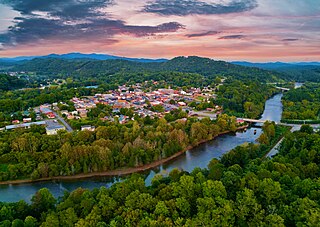
Murphy is a town in and the county seat of Cherokee County, North Carolina, United States. It is situated at the confluence of the Hiwassee and Valley rivers. It is the westernmost county seat in the state of North Carolina, approximately 360 miles (580 km) from the state capital in Raleigh. The population of Murphy was 1,608 at the 2020 census.

<span class="mw-page-title-main">Fayetteville, North Carolina</span> County seat of Cumberland County, North Carolina, United States

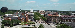
Fayetteville is a city in and the county seat of Cumberland County, North Carolina, United States. It is best known as the home of Fort Liberty, a major U.S. Army installation northwest of the city.

<span class="mw-page-title-main">Hope Mills, North Carolina</span> Town in North Carolina, United States

Hope Mills is a town in Cumberland County, North Carolina, United States. Its population was 15,176 at the 2010 census.

Beulaville is a town located in Duplin County, North Carolina, United States. As of the 2020 census, the population was 1,116. At the previous census in 2010, the population was 1,296. The community lies within the Limestone Creek Township.

Greenevers is a town in Duplin County, North Carolina, United States. As of the 2020 census, the population was 567. At the previous census in 2010, the population was 634.

<span class="mw-page-title-main">Kenansville, North Carolina</span> Town in North Carolina, United States

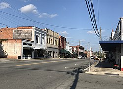
Kenansville is a town in Duplin County, North Carolina, United States. Its population was 770 at the 2020 census. It is the county seat of Duplin County. The town was named for James Kenan, a member of the North Carolina Senate. Liberty Hall, his early 1800s era historic home, is located within Kenansville.

Magnolia is a town in Duplin County, North Carolina, United States. As of the 2020 census, the population was 831. At the previous census in 2010, the population was 939.

<span class="mw-page-title-main">Rose Hill, North Carolina</span> Town in North Carolina, United States

Rose Hill is a town in Duplin County, North Carolina, United States. Its population was 1,371 at the 2020 census, down from 1,626 at the 2010 census. Rose Hill claims to be the home of the world's largest frying pan.

<span class="mw-page-title-main">Warsaw, North Carolina</span> Town in North Carolina, United States

Warsaw is a town in Duplin County, North Carolina, United States. The population was 3,054 at the 2010 census.

<span class="mw-page-title-main">Faison, North Carolina</span> Town in North Carolina, United States

Faison is a town primarily in Duplin County, North Carolina, with a small portion extending into Sampson County. As of the 2020 census, the population was 784. At the previous census in 2010, the population was 961.

<span class="mw-page-title-main">Mount Olive, North Carolina</span> Town in North Carolina, United States

Mount Olive is a town in Duplin and Wayne counties in the U.S. state of North Carolina. The population was 4,589 at the 2010 census. It is included in the Goldsboro, North Carolina Metropolitan Statistical Area. The town is home to the Mt. Olive Pickle Company and the University of Mount Olive.

<span class="mw-page-title-main">North Carolina Highway 11</span> State highway in North Carolina, US

North Carolina Highway 11 is a primary state highway in the U.S. state of North Carolina. Traveling 193.2 miles (310.9 km) in a north–south alignment through Eastern North Carolina, it connects the towns and cities of Wallace, Kenansville, Kinston, Greenville and Murfreesboro.

<span class="mw-page-title-main">Cape Fear (region)</span> Wilmington metropolitan area

Cape Fear is a coastal plain and Tidewater region of North Carolina centered about the city of Wilmington. The region takes its name from the adjacent Cape Fear headland, as does the Cape Fear River which flows through the region and empties into the Atlantic Ocean near the cape. Much of the region's populated areas are found along the Atlantic beaches and the Atlantic Intracoastal Waterway, while the rural areas are dominated by farms and swampland like that of the Green Swamp. The general area can be also identified by the titles "Lower Cape Fear", "Wilmington, NC Metropolitan Statistical Area", "Southeastern North Carolina", and "Azalea Coast". The latter name is derived from the North Carolina Azalea Festival held annually in Wilmington. Municipalities in the area belong to the Cape Fear Council of Governments.

<span class="mw-page-title-main">Marble, North Carolina</span> Census-designated place in North Carolina, United States

Marble is an unincorporated community and census-designated place (CDP) in Cherokee County, North Carolina, United States. As of the 2010 census it had a population of 321.

References

  1. "ArcGIS REST Services Directory". United States Census Bureau. Retrieved September 20, 2022.
  2. 1 2 U.S. Geological Survey Geographic Names Information System: Wallace, North Carolina
  3. 1 2 "U.S. Census website". United States Census Bureau . Retrieved January 31, 2008.
  4. "Wallace, NC | Data USA". datausa.io. Retrieved September 4, 2023.
  5. dcadmin76TR (June 22, 2018). "Wallace | Duplin County NC". www.duplincountync.com. Retrieved May 6, 2024.{{cite web}}: CS1 maint: numeric names: authors list (link)
  6. "National Register Information System". National Register of Historic Places . National Park Service. July 9, 2010.
  7. "Geographic Identifiers: 2010 Demographic Profile Data (G001): Wallace town, North Carolina". U.S. Census Bureau, American Factfinder. Archived from the original on February 13, 2020. Retrieved December 1, 2015.
  8. "Census of Population and Housing". Census.gov. Retrieved June 4, 2015.
  9. "Explore Census Data". data.census.gov. Retrieved December 24, 2021.
  10. "TOWN OF WALLACE MONTHLY TOWN COUNCIL MEETING" (PDF). Town of Wallace. March 14, 2024.
  11. "TOWN OF WALLACE MONTHLY TOWN COUNCIL MEETING" (PDF). Town of Wallace. February 8, 2024. Retrieved May 5, 2024.{{cite web}}: CS1 maint: url-status (link)
  12. "Tin City & Town Center Wallace, NC 28466, Neighborhood Profile - NeighborhoodScout". www.neighborhoodscout.com. Retrieved May 8, 2024.
  13. "Tin City & Town Center Wallace, NC 28466, Neighborhood Profile - NeighborhoodScout". www.neighborhoodscout.com. Retrieved May 6, 2024.
  14. "Homepage". River Landing. Retrieved May 6, 2024.
  15. "Northeast Volunteer Fire Department | Wallace, NC | Cause IQ". www.causeiq.com. Retrieved May 6, 2024.
  16. "Explore Census Data". data.census.gov. Retrieved May 6, 2024.
  17. "Explore Census Data". data.census.gov. Retrieved May 6, 2024.
  18. Nextdoor. "Pinhook/Deep Bottom, Wallace | News, Crime, Lost Pets, Free Stuff". nextdoor.com. Retrieved May 6, 2024.
  19. "Walker REIG | Reinvesting in our Local Community". Walker REIG. Retrieved May 6, 2024.
  20. "James N. Mattis". U.S. Department of Defense. Retrieved May 6, 2024.
  21. "Explore Census Data". data.census.gov. Retrieved May 6, 2024.
  22. "North Carolina Military Bases | MilitaryBases.com". Military Bases. Retrieved May 6, 2024.
  23. "NC Guard Armory Transferred to the Town of Wallace". DVIDS. Retrieved May 6, 2024.
  24. "Our Schools / School Directory". www.duplinschools.net. Retrieved May 6, 2024.
  25. "Our Schools / School Directory". www.duplinschools.net. Retrieved May 6, 2024.
  26. "Home". New Hope Christian Academy. Retrieved May 6, 2024.
  27. "Home". Wallace Christian Ac. Retrieved May 6, 2024.
  28. "Visitors – Town Of Wallace" . Retrieved May 6, 2024.
  29. "Visitors – Town Of Wallace" . Retrieved May 6, 2024.
  30. "Visitors – Town Of Wallace" . Retrieved May 6, 2024.
  31. "Visitors – Town Of Wallace" . Retrieved May 6, 2024.
  32. "Visitors – Town Of Wallace" . Retrieved May 6, 2024.
  33. david-old (June 13, 2011). "The Stockyard". NC Folk. Retrieved May 6, 2024.
  34. "Rockfish, Battle of | NCpedia". www.ncpedia.org. Retrieved May 8, 2024.
  35. Nate Irving Stats. Pro-Football-Reference. Retrieved December 18, 2020.
  36. The Carolina Times. (Durham, N.C.). newspapers.digitalnc.org. Retrieved December 18, 2020.
  37. Dickson, WK (April 12, 2016). "Airport Layout Plan Update" (PDF). Town of Wallace.
  38. "Rail study estimates Wilmington-to-Raleigh passenger service would be $810M, connects through Goldsboro". Port City Daily. April 23, 2024. Retrieved May 5, 2024.