Beulaville, North Carolina

Last updated

Beulaville, North Carolina
Seal of the Town of Beulaville.jpg
Motto: 
"A Place to Come Home To"
USA North Carolina location map.svg
Red pog.svg
Beulaville
Location within the state of North Carolina
Coordinates: 34°55′22″N77°46′21″W / 34.92278°N 77.77250°W / 34.92278; -77.77250
Country United States
State North Carolina
County Duplin
Government
   Mayor Hutch Jones
Area
[1]
  Total1.55 sq mi (4.00 km2)
  Land1.54 sq mi (4.00 km2)
  Water0.00 sq mi (0.00 km2)
Elevation
[2]
82 ft (25 m)
Population
 (2020)
  Total1,116
  Density722.33/sq mi (278.93/km2)
Time zone UTC-5 (Eastern (EST))
  Summer (DST) UTC-4 (EDT)
ZIP code
28518
Area codes 910, 472
FIPS code 37-05660 [3]
GNIS feature ID2405259 [2]
Website www.townofbeulaville.com

Beulaville is a town located in Duplin County, North Carolina, United States. As of the 2020 census, the population was 1,116. At the previous census in 2010, the population was 1,296. [4] The community lies within the Limestone Creek Township.

Contents

History

Native American Presence

The earliest Native Americans thought to have lived in the area were the Joara (whose settlements date back to AD 1000), based out of present-day Burke County. The Joara were the chiefdom of the Mississippian culture. Immediately prior to European colonization in the early 18th century, the coastal plain of North Carolina was home to many distinct Native American tribes: the Coree, Coharie, several small Neusiok communities, and the Tuscarora. This latter tribe gradually became the most dominant in the region as smaller tribes were either exterminated by Europeans or peacefully assimilated into the Tuscarora for collective security. By the time of permanent European settlement, the Tuscarora were utilizing the heavily forested areas of eastern Duplin County as a hunting ground.

Native American burial mounds are numerous in Duplin County, in the rural areas surrounding Beulaville especially. There are four sizable mounds within a ten-mile radius of the town, the two largest being in the vicinity of Hallsville and Sarecta. Combined, these mounds contain roughly one hundred bodies. [5]

European Settlement

The arrival of the Palatines at New Bern and the ensuing wave of English and Welsh settlers sparked a conflict known as the Tuscarora War (1710–1715). With the elimination of the last Tuscarora stronghold at Fort Neoheroka and subsequent exodus of the remainder of the tribe to New York (they became the sixth nation of the Iroquois Confederacy), the interior of the coastal plain was made available for European settlement. Many of the original European settlers of what is now Beulaville arrived from Beaufort, Craven, Jones, and Onslow counties.

In 1736, Duplin County (then upper New Hanover County) was the destination of several hundred Ulster Scots (Scotch-Irish) and a handful of Swiss Protestants. They settled on a plot of land, 71,160 acres (28,800 ha) between the Northeast Cape Fear River and Black River, obtained from the Crown by Henry McCulloh of London. [6] Their first settlements were Soracta (Sarecta) on the Northeast Cape Fear, an area at the lower end of Goshen Swamp (then called Woodward's Chase), and the grove where the Duplin County Courthouse now stands. [7] According to census records, several families of Sarecta and the settlement at the south end of Goshen Swamp had gravitated to the crossroads of what would become Beulaville by the middle of the nineteenth century.

Beulaville proper was founded as "Snatchet" in 1873 out of necessity for a trading center for nearby farmers and those in the business of logging and turpentine production. Also colloquially referred to as "Tearshirt" by locals, the town was once notorious for alcoholism and frequent street brawls. Indeed, the manufacture and distribution of corn liquor remained a steady source of income for many families well into the 20th century. Upon demolition of a prominent downtown building (which had formerly served as a soda shop in the 1950s) to make way for a McDonald's, a moonshine still and several barrels of the drink were uncovered in the basement. [8]

The Kinston Carolina Railroad and Lumber Company constructed a railway from Kinston to Pink Hill around 1900. In response, residents of Limestone Creek Township spent $15,000 to lobby for the creation of the "Duplin County Railroad" in 1916, extending the Kinston line through Beulaville and Chinquapin. The rail, which ran alongside present-day Railroad Street, has since been destroyed. [9] The post office of Snatchet was officially re-designated "Beulaville" in 1910, and the town was incorporated five years later. The town's name is derived from the Beulah Baptist Church (now the Beulaville Baptist Church). Beulaville is the most recent town to be incorporated in Duplin County.

Archie Lanier's Store Archie Lanier's Store.jpg
Archie Lanier's Store

Education

Former Beulaville High School, Currently Town Hall Former Beulaville High School.jpg
Former Beulaville High School, Currently Town Hall

In 1839, the county passed a tax for the creation of a public school system. Several decades later (sometime around 1870) the first public school in what would become Beulaville was constructed. The facility - which was no more than a small wood cabin - employed only one teacher. By 1901, however, four teachers were working out of the schoolhouse. [10] In 1906, property was purchased for a new school. A new two-story wooden building was erected and first used in the school year of 1917–1918; the enrollment for that year was nearly 200. Three additions – the auditorium, gym, and band building – were added in 1923, and additional tracts of land were purchased for the school between 1933 and 1950. On November 6, 1945, the school's main building burned to the ground. Only the John Hargett Gymnasium and auditorium were spared. School continued in these buildings and the teacherage located next door until the fall of 1947, when the elementary school building was rebuilt and a new high school building had been constructed. Potter's Hill Elementary merged with Beulaville in 1960, and integration was implemented shortly after.

Beulaville is home to one elementary/middle school (Beulaville Elementary) and one secondary school (East Duplin High School). The mascot for both schools, as well as nearby B. F. Grady, is the panther, referring to the eastern cougar which once roamed the swamps and forests of eastern North Carolina. East Duplin High School was built in 1963 and consolidates the elementary schools of Beulaville, B. F. Grady, and Chinquapin.

Geography

Beulaville is located on the coastal plain of North Carolina in Duplin County. It is situated at 85 feet (26 m) above sea level, with only minimal changes in topography. Limestone Creek, a small body of water that runs into the Northeast Cape Fear River at Hallsville, borders the western boundary of town. Beulaville is 90 miles (140 km) southeast of Raleigh and 312 miles (502 km) south of Washington, D.C.

According to the United States Census Bureau, the town has a total area of 1.5 square miles (3.9 km2), all land. [4]

Demographics

Historical population
CensusPop.Note
1880 32
1890 5159.4%
1920 354
1930 49439.5%
1940 56714.8%
1950 72427.7%
1960 1,06246.7%
1970 1,1568.9%
1980 1,060−8.3%
1990 933−12.0%
2000 1,06714.4%
2010 1,29621.5%
2020 1,116−13.9%
U.S. Decennial Census [11]

2020 census

Beulaville racial composition [12]
RaceNumberPercentage
White (non-Hispanic)68461.29%
Black or African American (non-Hispanic)27824.91%
Native American 90.81%
Asian 60.54%
Other/Mixed 474.21%
Hispanic or Latino 928.24%

As of the 2020 United States census, there were 1,116 people, 748 households, and 388 families residing in the town.

2000 census

As of the census [3] of 2000, there were 1,067 people, 442 households, and 274 families residing in the town. The population density was 734.8 inhabitants per square mile (283.7/km2). There were 501 housing units at an average density of 345.0 per square mile (133.2/km2). The racial makeup of the town was 73.48% White, 20.81% African American, 0.28% Native American, 0.19% Asian, 3.94% from other races, and 1.31% from two or more races. Hispanic or Latino of any race were 5.81% of the population.

There were 442 households, out of which 26.0% had children under the age of 18 living with them, 43.7% were married couples living together, 15.6% had a female householder with no husband present, and 38.0% were non-families. 35.5% of all households were made up of individuals, and 16.5% had someone living alone who was 65 years of age or older. The average household size was 2.24 and the average family size was 2.89.

In the town, the population was spread out, with 23.1% under the age of 18, 6.2% from 18 to 24, 21.3% from 25 to 44, 25.7% from 45 to 64, and 23.7% who were 65 years of age or older. The median age was 44 years. For every 100 females, there were 76.9 males. For every 100 females age 18 and over, there were 69.4 males.

The median income for a household in the town was $32,059, and the median income for a family was $40,347. Males had a median income of $30,104 versus $24,583 for females. The per capita income for the town was $19,571. About 15.4% of families and 18.9% of the population were below the poverty line, including 24.0% of those under age 18 and 11.7% of those age 65 or over.

Recreation

On the banks of the Northeast Cape Fear River at Hallsville Banks of the Northeast Cape Fear.JPG
On the banks of the Northeast Cape Fear River at Hallsville

Situated 4 miles (6 km) east of the meandering Northeast Cape Fear River, Beulaville offers much in the way of outdoor recreation. There are two boat landings on the Northeast Cape Fear River within a 7-mile (11 km) radius of town. The communal landing at Hallsville, which had, for centuries, been used by locals for activities ranging from baptisms to bonfires, has been closed off to the public. The other landing is located west of Beulaville, off Highway 24, half way to Kenansville. Several golf courses can also be found near Beulaville and in the greater Duplin area.

Within the town limits there are three public parks providing a variety of recreational needs, to include the William Ray Humphrey Athletic Park, a ballpark converted from the former elementary school's recreational fields. [13] The park, located behind the Beulaville Municipal Complex, boasts three baseball fields, two tennis courts, two outdoor basketball courts, and the John Hargett indoor gymnasium.

5 miles (8 km) north of Beulaville on Highway 111, the 167-acre Cabin Lake County Park attracts many locals and visitors for year-round camping, canoeing, and hiking. [14] Additionally, the Tarkil Branch Farm Museum at Cedar Fork, 7 miles (11 km) southeast of Beulaville, features a genuine 1830s homestead complete with over 850 artifacts; the operation is situated on a 375-acre working farm. [15]

Economy

Roadside tobacco barn near Sarecta Duplin-county-nc-tobacco-barn-1040875.jpg
Roadside tobacco barn near Sarecta
National Spinning, Beulaville location, which is no longer in business NationalSpinning.jpg
National Spinning, Beulaville location, which is no longer in business

The manufacture of naval stores and lumbering were the first marketable enterprises for the families inhabiting what is now Limestone Creek Township. These commodities were ferried down the Northeast Cape Fear River (which, in the early nineteenth century, had been made navigable) to Wilmington. As demand for naval stores fell, however, the cultivation of corn and, most importantly, tobacco moved to the forefront. As many of the small-scale tobacco growers dropped out of the market due to tobacco buyouts, an economic stimulus was needed; it came in the form of hogs. Agriculture is still the economic lifeline of Beulaville (Duplin now boasts the second highest hog-to-human ratio in the country), [16] though service industries and manufacturing jobs are gradually supplanting this tradition. Viticulture has noticeably increased throughout the area over the past decade as well. The North Carolina Global TransPark, a 2,500-acre (1,000 ha) multi-modal industrial air terminal, is located 30 miles (48 km) to the north in Kinston and is a perk for industry to locate to the area. Beulaville has also benefited from its proximity to Marine Corps Base Camp Lejeune 35 miles (56 km) to the southeast in both traffic volume on NC 24 en route to Interstate 40 and in job opportunities for citizens.

Notable nearby employers

CompanyIndustryEmployment (countywide)
Butterball, LLCManufacturing1000+
Smithfield Foods, IncManufacturing1000+
Duplin County SchoolsEducation1000+
House of Raeford, IncManufacturing1000+
Guilford Mills, IncManufacturing500-999
County of DuplinPublic Admin500-999
Murphy Family Ven.Natural Res.500-999
James Sprunt CCEducation250-499
Eastpointe Human ServicesManaged Care Organization100-249
Goshen MedicalHealth Svc.100-249
Superior Metal Structures & Concrete, LLCManufacturing10-15
Precision HydraulicManufacturing100-249
McDonald'sHospitality50-99

Churches

Beulaville Baptist Church BeulavilleBaptist.jpg
Beulaville Baptist Church

Main highways

Notable people

Related Research Articles

<span class="mw-page-title-main">Wayne County, North Carolina</span> County in North Carolina, United States

Wayne County is a county located in the U.S. state of North Carolina. As of the 2020 census, the population was 117,333. Its county seat is Goldsboro, and it is home to Seymour Johnson Air Force Base.

<span class="mw-page-title-main">Pender County, North Carolina</span> County in North Carolina, United States

Pender County is a county located in the U.S. state of North Carolina. As of the 2020 census, the population was 60,203. Its county seat is Burgaw. Pender County is part of the Wilmington, NC Metropolitan Statistical Area.

<span class="mw-page-title-main">Lenoir County, North Carolina</span> County in North Carolina, United States

Lenoir County is a county in the U.S. state of North Carolina. As of the 2020 census, its population was 55,122. Its county seat is Kinston, located on the Neuse River, across which the county has its territory.

<span class="mw-page-title-main">Jones County, North Carolina</span> County in North Carolina, United States

Jones County is a county located in the U.S. state of North Carolina. As of the 2020 census, the population was 9,172, making it the fourth-least populous county in North Carolina. Its county seat is Trenton. Jones County is part of the New Bern, NC Micropolitan Statistical Area.

<span class="mw-page-title-main">Duplin County, North Carolina</span> County in North Carolina, United States

Duplin County is a county located in the U.S. state of North Carolina. As of the 2020 census, the population was 48,715. Its county seat is Kenansville.

<span class="mw-page-title-main">Tar Heel, North Carolina</span> Town in North Carolina, United States

Tar Heel is a town located in Bladen County, North Carolina, United States. As of the 2010 census, the town population was 117.

<span class="mw-page-title-main">Kenansville, North Carolina</span> Town in North Carolina, United States

Kenansville is a town in Duplin County, North Carolina, United States. Its population was 770 at the 2020 census. It is the county seat of Duplin County. The town was named for James Kenan, a member of the North Carolina Senate. Liberty Hall, his early 1800s era historic home, is located within Kenansville.

<span class="mw-page-title-main">Snow Hill, North Carolina</span> Town in North Carolina, United States

Snow Hill is a town in Greene County, North Carolina, United States. The population was 1,595 at the 2010 census. It is the county seat of Greene County and is part of the Greenville Metropolitan Area. Snow Hill hosts numerous tennis tournaments during the year. Snow Hill is home to the Green Ridge Racquet Club. Many junior players and adults travel to Snow Hill in order to play in the USTA Sanctioned tournaments.

<span class="mw-page-title-main">Kinston, North Carolina</span> City in North Carolina, United States

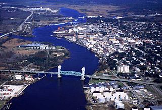
Kinston is a city in Lenoir County, North Carolina, United States, with a population of 19,900 as of the 2020 census. It has been the county seat of Lenoir County since its formation in 1791. Kinston is located in the coastal plains region of eastern North Carolina.

<span class="mw-page-title-main">Wallace, North Carolina</span> Town in North Carolina, United States

Wallace is a town in Duplin and Pender counties in the U.S. state of North Carolina. The population was 3,883 at the 2020 census. The Pender County portion of Wallace is part of the Wilmington Metropolitan Statistical Area. The town of Wallace was first known as Duplin Crossroads and was incorporated into existence in 1873. Later in 1899, the town fathers decided to adopt the new name, Wallace, to honor Stephen D. Wallace, an official of the Atlantic Coast Line Railroad. Wallace is Duplin County's largest population and retail trade center serving over 50,000 people in a surrounding three county area.

<span class="mw-page-title-main">Northeast Cape Fear River</span> Stream in North Carolina, USA

Northeast Cape Fear River is a 131.2 mi (211.1 km) long 5th order tributary to the Cape Fear River in southeastern North Carolina.

<span class="mw-page-title-main">Mount Olive, North Carolina</span> Town in North Carolina, United States

Mount Olive is a town in Duplin and Wayne counties in the U.S. state of North Carolina. The population was 4,589 at the 2010 census. It is included in the Goldsboro, North Carolina Metropolitan Statistical Area. The town is home to the Mt. Olive Pickle Company and the University of Mount Olive.

Chinquapin is an unincorporated community and census-designated place (CDP) located adjacent to the Northeast Cape Fear River in Duplin County, North Carolina, United States. It was first listed as a CDP in the 2020 census with a population of 86.

<span class="mw-page-title-main">North Carolina Highway 11</span> State highway in North Carolina, US

North Carolina Highway 11 is a primary state highway in the U.S. state of North Carolina. Traveling 193.2 miles (310.9 km) in a north–south alignment through Eastern North Carolina, it connects the towns and cities of Wallace, Kenansville, Kinston, Greenville and Murfreesboro.

<span class="mw-page-title-main">Sarecta, North Carolina</span> Formerly incorporated community in North Carolina, United States

Sarecta was the first incorporated town in Duplin County, North Carolina, established in 1787. In 1736, Duplin County was the destination of several hundred Ulster Scots (Scotch-Irish) and a handful of Swiss Protestants. They settled on a plot of land, 71,160 acres between the N. E. Cape Fear River and Black River, obtained from the Crown by Henry McCulloh Esq. of London. Sarecta, originally called Sorcata, was the first settlement in the region on the Northeast Cape Fear.

<span class="mw-page-title-main">Cape Fear (region)</span> Wilmington metropolitan area

Cape Fear is a coastal plain and Tidewater region of North Carolina centered about the city of Wilmington. The region takes its name from the adjacent Cape Fear headland, as does the Cape Fear River which flows through the region and empties into the Atlantic Ocean near the cape. Much of the region's populated areas are found along the Atlantic beaches and the Atlantic Intracoastal Waterway, while the rural areas are dominated by farms and swampland like that of the Green Swamp. The general area can be also identified by the titles "Lower Cape Fear", "Wilmington, NC Metropolitan Statistical Area", "Southeastern North Carolina", and "Azalea Coast". The latter name is derived from the North Carolina Azalea Festival held annually in Wilmington. Municipalities in the area belong to the Cape Fear Council of Governments.

Duplin County Schools is a PK–12 graded school district serving Duplin County, North Carolina. Its 16 schools serve 9,145 students as of the 2010–11 school year.

<span class="mw-page-title-main">North Carolina Highway 403</span> State highway in North Carolina, US

North Carolina Highway 403 (NC 403) is a primary state highway located in U.S. State of North Carolina. The highway travels through Sampson, Duplin, and Wayne Counties between its southern terminus at U.S. Route 701 Business in Clinton and NC 55 in Williams. Between its termini, NC 403 connects to Interstate 40 (I-40) and Faison. The highway is primarily rural and predominantly travels through rural forests and farmlands. While signed in a north-south direction, NC 403 physically travels in a northeast-southwest direction along the duration of its route.

<span class="mw-page-title-main">North Carolina Highway 241</span> State highway in North Carolina, US

North Carolina Highway 241 (NC 241) is a primary state highway in the U.S. state of North Carolina. NC 241 travels for 9.1 miles (14.6 km) from NC 41 and NC 111 in Beulaville to NC 11 in Pink Hill. Outside of Beulaville and Pink Hill, NC 241 is a rather straight, predominantly rural route. The highway travels through Duplin County for 7.6 miles (12.2 km) while traveling 1.5 miles (2.4 km) in Lenoir County.

<span class="mw-page-title-main">Hallsville, North Carolina</span> Town in North Carolina, United States

Hallsville is an unincorporated community located adjacent to the Northeast Cape Fear River in Duplin County, North Carolina, United States.

References

  1. "ArcGIS REST Services Directory". United States Census Bureau. Retrieved September 20, 2022.
  2. 1 2 U.S. Geological Survey Geographic Names Information System: Beulaville, North Carolina
  3. 1 2 "U.S. Census website". United States Census Bureau . Retrieved January 31, 2008.
  4. 1 2 "Geographic Identifiers: 2010 Demographic Profile Data (G001): Beulaville town, North Carolina". U.S. Census Bureau, American Factfinder. Archived from the original on February 13, 2020. Retrieved November 30, 2015.
  5. "Notes on the Indian burial mounds of eastern North Carolina". Retrieved November 19, 2013.
  6. "The Royal Colony of North Carolina - Henry McCulloch, Esq".
  7. William Dickson. "Duplin County History to 1810". Duplin County community website. Archived from the original on January 24, 2016. Retrieved November 30, 2015.
  8. "Rowdy Town". WRAL.com. February 18, 2008. Retrieved November 19, 2013.
  9. Report of the Corporation Commission for the Biennial Period ..., Issue 19
  10. "Beulaville, North Carolina: A History". Retrieved November 19, 2013.
  11. "Census of Population and Housing". Census.gov. Retrieved June 4, 2016.
  12. "Explore Census Data". data.census.gov. Retrieved December 24, 2021.
  13. "Parks & Recreation". Archived from the original on January 25, 2016. Retrieved December 26, 2015.
  14. "Cabin Lake Recreational Park".
  15. "Welcome to Tarkil Branch Farm's Homestead Museum".
  16. "Environmental Justice Case Study: Hog Farming in North Carolina". University of Michigan students. Retrieved November 30, 2015.
  17. "Index to Politicians". Politicalgraveyard.com. Retrieved August 28, 2014.