Southern Pines, North Carolina

Last updated

Southern Pines, North Carolina
Amtrak Station - Southern Pines, North Carolina.jpg
Southern Pines, NC Town Seal.svg
Moore County North Carolina incorporated and unincorporated areas Southern Pines highlighted.svg
Location of Southern Pines in Moore County, North Carolina (bottom) and of Moore County in North Carolina (top)
Coordinates: 35°11′36″N79°24′14″W / 35.19333°N 79.40389°W / 35.19333; -79.40389
CountryUnited States
State North Carolina
County Moore
Named for Its location on the edge of the Longleaf pine belt [1]
Government
   Mayor Carol Haney
Area
[2]
   Town 17.76 sq mi (45.99 km2)
  Land17.57 sq mi (45.50 km2)
  Water0.19 sq mi (0.49 km2)
Elevation
[3]
512 ft (156 m)
Population
 (2020)
   Town 15,545
  Density884.95/sq mi (341.69/km2)
   Urban
50,319 (US: 506th) [4]
  Urban density1,058.1/sq mi (408.5/km2)
Time zone UTC−5 (Eastern (EST))
  Summer (DST) UTC−4 (EDT)
ZIP codes
28387-28388
Area codes 910, 472
FIPS code 37-63120 [5]
GNIS feature ID2407374 [3]
Website www.southernpines.net

Southern Pines is a town in Moore County, North Carolina, United States. The population was 12,334 as of the 2010 United States Census.

Contents

History

Founded as a winter health resort for Northerners, [6] land for the establishment of a town was purchased in 1884 [6] and the town was incorporated on March 7, 1887. [7] [8]

As of 1898, it was a sundown town where African Americans were not allowed to reside or conduct business. [9]

The James Boyd House, Shaw House, Southern Pines Historic District, Firleigh Farms, and Moore County Hunt Lands and Mile-Away Farms are listed on the National Register of Historic Places. [10] [11] [12] The Southern Pines Golf Club was founded in 1906.

Geography

According to the United States Census Bureau, the town has a total area of 15.5 square miles (40.2 km2), of which 15.4 square miles (39.8 km2) is land and 0.2 square mile (0.5 km2) (1.16%) is water.

Demographics

Historical population
CensusPop.Note
1900 517
1910 5424.8%
1920 74337.1%
1930 2,524239.7%
1940 3,22527.8%
1950 4,27232.5%
1960 5,19821.7%
1970 5,93714.2%
1980 8,62045.2%
1990 9,1295.9%
2000 10,91819.6%
2010 12,33413.0%
2020 15,54526.0%
U.S. Decennial Census [13]
Shops along N Broad Street Southern Pines N Broad St Shops.jpg
Shops along N Broad Street

2020 census

Southern Pines racial composition [14]
RaceNumberPercentage
White (non-Hispanic)11,12671.57%
Black or African American (non-Hispanic)2,60916.78%
Native American 640.41%
Asian 2321.49%
Pacific Islander 130.08%
Other/Mixed 6834.39%
Hispanic or Latino 8185.26%

As of the 2020 United States census, there were 15,545 people, 6,321 households, and 3,505 families residing in the town.

2010 census

As of the 2010 census, [5] there were 12,334 people, 5,866 households, and 3,304 families residing in the town. The population density was 806 inhabitants per square mile (311/km2). There were 6,859 housing units at an average density of 371 houses/condos per square mile (143.24/km2). The racial makeup of the town was 71.7% White, 24% African American, 0.6% Native American, 0.8% Asian, 0.1% Pacific Islander, 1.3% from other races, and 1.4% from two or more races. Hispanic or Latino of any race were 1.4% of the population. [15]

Of the 5,866 households, 21% had children under the age of 18 living with them, 40.6% were married couples living together, 13% had a female householder with no husband present, 2.7 had a male householder with no female present, and 38.9% were non-families. The average household size was 2.07 and the average family size was 2.75. [15]

In the town, the population was spread out, with 21.9% aged 19 and younger, 4.7% from 20 to 24, 20.8% from 25 to 44, 25.2% from 45 to 64, and 27.5% who were 65 years of age or older. The median age was 47. For every 100 females, there were 82 males. For every 100 females age 18 and over, there were 78.2 males. [15]

The median income for a household in the town was $41,297 in 2011, [16] and the median income for a family was $60,683. [17] Males had a median income of $29,855 versus $23,920 for females. The per capita income for the town was $30,886. [17] Of families, 9.26% were below the poverty level, along with 12.4% of the population poverty line, including 23.0% of those under age 18 and 9.6% of those age 65 or over.

Education

Media

The metro area has TV broadcasting stations that serve the Raleigh-Durham Designated Market Area (DMA) as defined by Nielsen Media Research.

Infrastructure

Notable people

Sister city

Southern Pines has one sister city, as designated by Sister Cities International: [21]

Related Research Articles

<span class="mw-page-title-main">Moore County, North Carolina</span> County in North Carolina, United States

Moore County is a county located in the U.S. state of North Carolina. As of the 2020 census, its population was 99,727. Its county seat is Carthage and its largest community Pinehurst. It is a border county between the Piedmont and the Atlantic Coastal Plain.

<span class="mw-page-title-main">Lee County, North Carolina</span> County in North Carolina, United States

Lee County is a county located in the U.S. state of North Carolina. As of the 2020 census, the population was 63,285. The county seat is Sanford.

<span class="mw-page-title-main">Graham, North Carolina</span> City in North Carolina, United States

Graham is a city in Alamance County, North Carolina, United States. It is part of the Burlington, North Carolina Metropolitan Statistical Area. As of the 2020 census the population was 17,153. It is the county seat of Alamance County.

<span class="mw-page-title-main">Webster, North Carolina</span> Town in North Carolina, United States

Webster is a town in Jackson County, North Carolina, United States. As of the 2010 census, the population was 363, down from 486 in 2000.

<span class="mw-page-title-main">Spruce Pine, North Carolina</span> Town in North Carolina, United States

Spruce Pine is the largest town in Mitchell County, North Carolina, United States. The population was 2,175 at the 2010 census.

<span class="mw-page-title-main">Troy, North Carolina</span> Town in North Carolina, United States

Troy is a town in Montgomery County, North Carolina, United States. The population was 3,188 at the 2010 census. It is the county seat of Montgomery County. A short story by Charles W. Chesnutt, The Sheriff's Children, is set in Troy.

<span class="mw-page-title-main">Aberdeen, North Carolina</span> Town in North Carolina, United States

Aberdeen is a town in Moore County, North Carolina, United States. The population was 6,350 at the 2010 census.

<span class="mw-page-title-main">Pinebluff, North Carolina</span> Town in North Carolina, United States

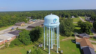
Pinebluff is a town in Moore County, North Carolina, United States. The population was 1,337 at the 2010 census.

<span class="mw-page-title-main">Pinehurst, North Carolina</span> Village in North Carolina, United States

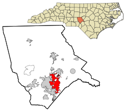
Pinehurst is a village in Moore County, North Carolina, United States. As of the 2020 census, the village population was 17,581. It is home of the historic Pinehurst Resort, a Golf resort, which has hosted multiple United States Open Championships in the sport. The village lies adjacent to the Pine Needles Lodge and Golf Club, which has hosted multiple U.S. Open tournaments in Women's Golf. A large portion of the central village, including the resort complexes, is a National Historic Landmark District, designated in 1996 for its landscape design and its significance in the history of golf in the United States. Pinehurst has been designated as the "Home of American Golf" by the United States Golf Association, which announced a second headquarters in the village in 2020. The area is also known for its strong equestrian community, has hosted the former Stoneybrook Steeplechase, and currently maintains the Pinehurst Harness Track. Fox hunting is also a common sport in the area.

<span class="mw-page-title-main">Vass, North Carolina</span> Town in North Carolina, United States

Vass is a town in Moore County, North Carolina, United States. The population was 720 at the 2010 census. Vass grew up along the railroad in the late 19th century. It was originally named Bynum and later Winder before being established as Vass in 1892. The town was incorporated in 1907.

<span class="mw-page-title-main">Madison, North Carolina</span> Town in North Carolina, United States

Madison is a town located in Rockingham County, North Carolina. At the 2020 census, the town had a total population of 2,132. Madison is part of the Greensboro-High Point Metropolitan Statistical Area of the Piedmont Triad metro region. It was home to the corporate headquarters of Remington Arms until 2020, when the company was made defunct by bankruptcy proceedings. It is still home to Marlin Firearms, which was an asset of Remington now owned by Sturm, Ruger & Co.

<span class="mw-page-title-main">Walnut Cove, North Carolina</span> Town in North Carolina, United States

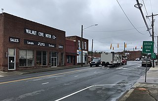
Walnut Cove is a town in Stokes County, North Carolina, United States. The population was 1,536 at the 2020 census.

<span class="mw-page-title-main">Dobson, North Carolina</span> Town in North Carolina, United States

Dobson is a town in Dobson Township, Surry County, North Carolina, United States. As of the 2020 census, the town population was 1,396. It is the county seat of Surry County. Dobson is the home of the Shelton Vineyards, the largest winery in North Carolina. It is also home to a significant Latino population due to the large number of farms in the area. The main crops in the area are corn, tobacco and soy beans.

<span class="mw-page-title-main">Burnsville, North Carolina</span> Town in North Carolina, United States

Burnsville is a town that serves as the county seat of Yancey County, North Carolina, United States. Located in the Blue Ridge Mountains of western North Carolina, sits in the shadow of Mount Mitchell, the highest peak in the Eastern Continental United States. The population was 1,612 at the 2020 census.

<span class="mw-page-title-main">Warwick Township, Chester County, Pennsylvania</span> Township in Pennsylvania, United States

Warwick Township is a township in Chester County, Pennsylvania, United States. The population was 2,507 at the 2010 census.

<span class="mw-page-title-main">Jefferson, South Carolina</span> Town in South Carolina, United States

Jefferson is a town in western Chesterfield County, South Carolina, United States at the junction of SC routes 265 and 151. Jefferson is located in the Piedmont region of South Carolina just in the edge meeting the Sandhills region. Jefferson is located 16 miles northwest of McBee, 8 miles south of Pageland, 50 miles southeast of Charlotte, North Carolina, and 70 miles north-northeast of the state capitol Columbia. As of the 2010 census, the city population was 753.

<span class="mw-page-title-main">Patrick, South Carolina</span> Town in South Carolina, United States

Patrick is a town in Chesterfield County, South Carolina, United States. The population was 351 at the 2010 census.

<span class="mw-page-title-main">Gaston, South Carolina</span> Town in South Carolina, United States

Gaston is a town in Lexington County, South Carolina, United States. The population was 1,645 at the 2010 census. It is part of the Columbia, South Carolina Metropolitan Statistical Area.

<span class="mw-page-title-main">Swansea, South Carolina</span> Town in South Carolina, United States

Swansea is a town in Lexington County, South Carolina, United States. The population was 827 at the 2010 census. It is part of the Columbia, South Carolina Metropolitan Statistical Area.

<span class="mw-page-title-main">Mount Olive, North Carolina</span> Town in North Carolina, United States

Mount Olive is a town in Duplin and Wayne counties in the U.S. state of North Carolina. The population was 4,589 at the 2010 census. It is included in the Goldsboro, North Carolina Metropolitan Statistical Area. The town is home to the Mt. Olive Pickle Company and the University of Mount Olive.

References

  1. "North Carolina Gazetteer" . Retrieved December 8, 2022.
  2. "ArcGIS REST Services Directory". United States Census Bureau. Retrieved September 20, 2022.
  3. 1 2 U.S. Geological Survey Geographic Names Information System: Southern Pines, North Carolina
  4. United States Census Bureau (December 29, 2022). "2020 Census Qualifying Urban Areas and Final Criteria Clarifications". Federal Register.
  5. 1 2 "U.S. Census website". United States Census Bureau . Retrieved January 31, 2008.
  6. 1 2 Southern Pines North Carolina 2040 Comprehensive Plan Adopted September 12, 2023, https://www.southernpines.net/DocumentCenter/View/10470/2040-Comprehensive-Plan-printable-version, last accessed November 12, 2023.
  7. An Act to Incorporate the Town of Southern Pines, in Moore county, ratified March 7, 1887, https://www.southernpines.net/DocumentCenter/View/9784/Southern-Pines-Charter-1887-Session-Law-Chapter-159?bidId=, last accessed November 12, 2023.
  8. Southern Pines Comprehensive Long Range Plan 2016, p. B-26.
  9. "State Press". The Semi-Weekly Messenger. Wilmington, North Carolina. November 18, 1898. p. 4 via Chronicling America. Southern Pines, in Moore county, this state, is a typical northern community. It was built, is settled and is governed by people from the northern and New England states, and it is interesting to know how the negro is treated there. … Southern Pines was founded by eastern capitalists as a resort for invalids and hundreds go there every winter seeking restoration of health. Its founders, notwithstanding their birth-place and traditions, did not allow any sentimental notions about the negroes to enter in their plans. No negro is allowed to live or do business in Southern Pines. They are all congregated in a place called 'Jimtown', and when they visit the town proper, are models of quiet and orderly behavior.
  10. "National Register Information System". National Register of Historic Places . National Park Service. July 9, 2010.
  11. "National Register of Historic Places Listings". Weekly List of Actions Taken on Properties, 9/09/13 through 9/13/13. National Park Service. September 20, 2013.
  12. "National Register of Historic Places Listings". Weekly List of Actions Taken on Properties: 5/29/14 through 5/23/14. National Park Service. May 30, 2014.
  13. "Census of Population and Housing". Census.gov. Retrieved June 4, 2015.
  14. "Explore Census Data". data.census.gov. Retrieved December 22, 2021.
  15. 1 2 3 "2010 Census data for City of Southern Pines, NC". www.zip-codes.com. Retrieved April 6, 2018.
  16. "Southern Pines, North Carolina (NC 28387) profile: population, maps, real estate, averages, homes, statistics, relocation, travel, jobs, hospitals, schools, crime, moving, houses, news, sex offenders". www.city-data.com. Retrieved April 6, 2018.
  17. 1 2 "Southern Pines, NC Income and Careers - USA.com™". www.usa.com. Retrieved April 6, 2018.
  18. Shaw Names Bobby Collins New Head Men's Basketball Coach. shawbears.com. Retrieved July 28, 2020.
  19. Levin, Rachel. (May 28, 2013). An Ultrarunner's Long Road Back. Outside. Retrieved July 28, 2020.
  20. Blues with Toni Lynn Washington. Retrieved July 28, 2020.
  21. Sahadi, Bill. (June 8, 2017). Sister Cities International. Fore Properties. Retrieved July 21, 2020.

Works cited