
The Eno River, named for the Eno Native Americans who once lived along its banks, is the initial tributary of the Neuse River in North Carolina, United States. Descendants of European immigrants settled along the Eno River in the latter 1740s and early 1750s, including many Quakers from Pennsylvania. Several years after the 1752 creation of Orange County, the Orange County Court of Common Pleas & Quarter Sessions selected a site along the Eno River near the homes of James Watson and William Reed as the county seat, originally naming it Corbin Town, or Corbinton, after Francis Corbin, agent and attorney to John, Earl Granville. The Court met at James Watson's home along the Eno River from 1754 through 1756, when the courthouse at Corbinton was completed. In 1759, officials changed the county seat's name from Corbinton to Childsburg, after another of Earl Granville's agents, Thomas Child. Finally, in 1766, officials changed the name to Hillsborough.
The Fisher River is a tributary of the Yadkin River in northwestern North Carolina in the United States, also draining a very small portion of southwestern Virginia. Via the Yadkin it is part of the watershed of the Pee Dee River, which flows to the Atlantic Ocean. According to the Geographic Names Information System, it has also been known historically as "Big Fishers River," "Fish River" and "Fishe River."
The Ararat River is a tributary of the Yadkin River in southwestern Virginia and northwestern North Carolina in the United States. Via the Yadkin it is part of the watershed of the Pee Dee River, which flows to the Atlantic Ocean.
The Flat River is a river in southern Person County, North Carolina and a portion of Durham County, North Carolina.

Crabtree Creek is a tributary of the Neuse River in central Wake County, North Carolina, United States. The creek begins in the town of Cary and flows through Morrisville, William B. Umstead State Park, and the northern sections of Raleigh before emptying into the Neuse at Anderson Point Park, a large city park located in East Raleigh.

Abbotts Creek starts in Kernersville, NC in Forsyth County and flows into High Rock Lake near Lexington, NC in Davidson County just north of Hwy 47. The section of High Rock Lake that is officially Abbotts Creeks ends near the Hwy 8 causeway, in Southmont, NC.

The Trent River is a fresh water river of the coastal plain region of eastern North Carolina. It flows in an easterly direction from its origin approximately 15 miles (24 km) southwest of Kinston, North Carolina and traverses portions of Lenoir County, Jones County and Craven County prior to emptying into the Neuse River at New Bern, North Carolina. Trenton and Pollocksville are small towns that lie along its course. The river measures 720 yards (660 m) at its widest point and is fed by numerous fresh water branches and creeks along its length.
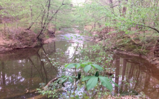
Little River is a 12.83 mi (20.65 km) long tributary to the Eno River in Durham County, North Carolina. Little River along with the Flat River are the major tributaries to the Eno River before it enters Falls Lake.
Brown Creek is a tributary of the Pee Dee River in south-central North Carolina and north-central South Carolina that drains Chesterfield County, South Carolina, Union County, North Carolina, and Anson County, North Carolina.
Richardson Creek is a tributary of the Rocky River in south-central North Carolina that rises in Union County near Monroe and then flows northeast through Anson County to the Rocky River.
Sycamore Creek is a tributary to Crabtree Creek that rises in a pond near Lynns Crossroads in Durham County then flows southward to join Crabtree Creek in Wake County, North Carolina. Sycamore Creek flows mostly through William B. Umstead State Park. The watershed is more forested at 43% than most in the Crabtree Creek watershed.

Haleys Branch is a tributary to Crabtree Creek that rises just south of the Raleigh-Durham (RDU) airport then flows south to meet Crabtree Creek in Lake Crabtree. The watershed is about 68% forested.
Turkey Creek rises in southwest Cary, North Carolina and then flows northeast to join Crabtree Creek. The watershed is about 5% forested.
House Creek is a 3.22 mi (5.18 km) long 1st order tributary of Crabtree Creek in Wake County, North Carolina.
Walnut Creek is a 17.93 mi (28.86 km) long 4th order tributary to the Neuse River in Wake County. Its source is a small pond near WakeMed Soccer Park in Cary, and it flows generally eastward through several small reservoirs, including Lake Cramer in Cary as well as Lake Johnson and Lake Raleigh in Raleigh, before reaching its confluence with the Neuse just south of Poole Road in East Raleigh. The course of the creek closely parallels Interstate 40, running mostly along the north side of the freeway.
Roberson Creek is a 11.81 mi (19.01 km) long 3rd order tributary to the Haw River in Chatham County, North Carolina.
Service Creek is a 5.93 mi (9.54 km) long 2nd order tributary to the Haw River, in Alamance County, North Carolina.
Cane Creek is a 13.74 mi (22.11 km) long 4th order tributary to the Haw River, in Alamance and Orange Counties, North Carolina. This Cane Creek is on the left bank of the Haw River.
Lanes Creek is a 37.19 mi (59.85 km) long 4th order tributary of the Rocky River in south-central North Carolina that drains Union County, North Carolina, and Anson County, North Carolina.
Haven Creek is a 3.85 mi (6.20 km) long 2nd order tributary to the Haw River in Chatham County, North Carolina. The name of Haven Creek comes from Haven Estate from which it flows.

