Jordan Lake

Last updated

B. Everett Jordan Lake
Jordan Lake Sunrise.jpg
The sun rising over Jordan Lake, taken from Farrington Road
USA North Carolina relief location map.jpg
Red pog.svg
B. Everett Jordan Lake
Usa edcp relief location map.png
Red pog.svg
B. Everett Jordan Lake
Location Chatham / Durham counties, North Carolina, United States
Coordinates 35°45′0″N79°1′30″W / 35.75000°N 79.02500°W / 35.75000; -79.02500
Lake type Reservoir
Primary inflows Haw River, New Hope Creek, Morgan Creek, and Little Creek
Primary outflows Haw River
Basin  countriesUnited States
Managing agency United States Army Corps of Engineers
Max. length16 miles (26 km) [1]
Max. width5 miles (8.0 km) [1]
Surface area 13,940 acres (56.4 km2)
31,800 acres (129 km2) flood control pool [1]
Average depth14 feet (4.3 m) [1]
Max. depth38 feet (12 m) [1]
Water volume 215,100 acre-feet (265.3 hm3)
Shore length1180 mi (290 km) [1]
Surface elevation216 ft (66 m) [1]
Frozennever
1 Shore length is not a well-defined measure.

B. Everett Jordan Lake is a reservoir in New Hope Valley, west of Cary and south of Durham in Chatham County, North Carolina, in the United States; the northernmost end of the lake extends into southwestern Durham County.

Contents

Part of the Jordan Lake State Recreation Area, [1] the reservoir covers 13,940 acres (5,640 ha) with a shoreline of 180 miles (290 km) at its standard water level of 216 feet (66 m) above sea level. It was developed as part of a flood control project prompted by a particularly damaging tropical storm that hit the region downstream in September 1945. Constructed at an original cost of US$146,300,000, it is owned and operated by the United States Army Corps of Engineers, which dammed and flooded the Haw River and New Hope River between 1973 and 1983.

Construction

The Jordan Lake Dam (also known as the B. Everett Jordan Project and the New Hope Dam) is located at 35°39′15″N79°4′0″W / 35.65417°N 79.06667°W / 35.65417; -79.06667 (B. Everett Jordan Dam) 4 miles (6.4 km) upstream from the mouth of the Haw River in the upper Cape Fear River drainage basin. Completed in 1974 by the Nello L. Teer Company, it is 1,330 feet (410 m) in length and has a top elevation of 266.5 feet (81.2 m) above mean sea level. [1]

During the construction of the reservoir, much of the area was permanently changed. The Durham and South Carolina Railroad was relocated from the New Hope basin to higher ground but its stations were not rebuilt, and the line itself was soon abandoned. [2] Many farming families were relocated as the project was developed and several roads in eastern Chatham County were either rerouted or taken out of commission completely. Some of the roads were never demolished, but simply allowed to flood over. When the lake is at low water volume, many of these roads can still be seen and some have even been utilized for makeshift boat ramps. [3]

Originally authorized in 1963 as the New Hope Lake Project, the reservoir was renamed in 1974 in memory of B. Everett Jordan, former US Senator from North Carolina.

Water supply

The northern end of Jordan Lake, near the Morgan Creek inlet Jordan Lake-27527.jpg
The northern end of Jordan Lake, near the Morgan Creek inlet

Jordan Lake serves as a major water supply for central North Carolina. Allocations made in Round 4 total 95.9% of the water supply pool. Governmental units allocated water from Jordan Lake in Round 4 (approved by the NC EMC on March 9, 2017) include the system jointly operated by Towns of Cary and Apex, which also serves Morrisville and the Wake County portion of Research Triangle Park (46.2%); Chatham County North (13%); City of Durham (16.5%); Town of Holly Springs (2%); Orange County (1.5%); Orange Water & Sewer Authority (5%); City of Raleigh (4.7%); Town of Pittsboro (6%). [4] [5] However, in 2019, following the fourth round of allocations the City of Raleigh relinquished its 4.7% water supply pool allocation. As such it is expected that the remaining unallocated portion of the water supply pool is 8.8%.

Previously, allocations made in 2002 totalled 63 mgd (1% is often assumed to be equal to 1 mgd, but allocations are officially by percentage of the total water supply pool). Governmental units allocated water from Jordan Lake at that time were the Towns of Cary and Apex (32 mgd), Chatham County (6 mgd), City of Durham (10 mgd), Town of Holly Springs (2 mgd), Town of Morrisville (3.5 mgd), Orange County (1 mgd), Orange Water & Sewer Authority (5 mgd), and Wake County - RTP South (3.5 mgd). [6] [7] [8]

Northeast Creek Inlet of Jordan Lake Northeast Creek Inlet of Jordan Lake.png
Northeast Creek Inlet of Jordan Lake

Water quality

Jordan Lake was declared as nutrient-sensitive waters (NSW) by the North Carolina Environmental Management Commission from 1983, the year it was impounded. The lake is eutrophic or hyper-eutrophic owing to excessive nutrient levels. [9]

Jordan Lake offers a variety of facilities for recreation, conservation, and flood control. B. Everett Jordan Lake Map.png
Jordan Lake offers a variety of facilities for recreation, conservation, and flood control.

Requirements of the federal Clean Water Act were triggered when the lake became impaired, including the need to set load reduction limits for point and nonpoint sources and enforce discharge limits. [10]

The Jordan Lake Rules are designed to improve water quality in the lake. The rules were developed with extensive meetings, public hearings and negotiations between residents, environmental groups, local and state government agencies and other stakeholders. The rules mandate reducing pollution from wastewater discharges, stormwater runoff from new and existing development, agriculture and fertilizer application. [11] [12]

From July 2011 several NC laws have been passed delaying and weakening the rules, culminating in a plan to deploy floating arrays of in-lake circulators intended to reduce harmful algae and excessive chlorophyll. [13] [14] However, they proved ineffective in a testing program and were removed in 2016.

On December 21, 2017, researchers at Duke University have discovered elevated levels of several perfluorinated compounds an unregulated family of industrial chemicals including some that can raise cancer risks in Jordan Lake and drinking water treated by the town of Cary. Cary water treatment officials, who have independently confirmed the findings of Duke researchers, say the town's water is safe to drink. They also point out that the compounds detected are still below health advisory levels set by the U.S. Environmental Protection Agency. Testing still continues as of March 8, 2018. [15]

A boat launch ramp at Jordan Lake. Jordan Lake Boat Ramp.jpg
A boat launch ramp at Jordan Lake.

Shoreline trash cleanup

A sign by the lake reads, "Glass / cans and pets prohibited on beach". Jordan Lake Durham.jpg
A sign by the lake reads, "Glass / cans and pets prohibited on beach".

Bald eagle habitat being endangered by trash submerged by the lake's creation spurred volunteer efforts to clean up the shoreline and other sensitive areas. [16] [17]

In 2009 the U.S. Army Corps of Engineers worked with local activists to establish Clean Jordan Lake, a nonprofit "friends of the lake" group. [18] [19] Volunteer cleanups aided by the Corps of Engineers began in 2010. [20] [21] Since then, Clean Jordan Lake has organized over 300 community service cleanups, formed the Adopt-A-Shoreline Program that comprises 19 groups that clean habitually littered areas three times per year, and formed the Adopt-A-Feeder Stream Program with semi-annual cleanups to prevent trash from reaching the lake. As of late 2017, 5,600 volunteers have removed 13,500 bags of trash (enough to fill 40 large dumpsters) and 4,300 tires. Clean Jordan Lake estimates that 80% of the trash is from stormwater runoff and 20% from recreational use of the lake. [22] [23]

Related Research Articles

<span class="mw-page-title-main">Cary, North Carolina</span> Town in North Carolina, US

Cary is a town in Wake, Chatham, and Durham counties in the U.S. state of North Carolina and is part of the Raleigh-Cary, NC Metropolitan Statistical Area. According to the 2020 census, its population was 174,721, making it the seventh-most populous municipality in North Carolina, and the 148th-most populous in the United States. In 2022, the town's population had increased to 180,388.

<span class="mw-page-title-main">American Tobacco Trail</span>

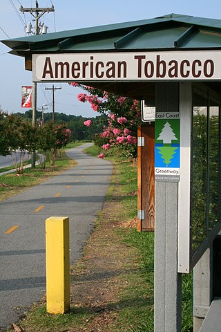
The American Tobacco Trail (ATT) is a 22.6-mile (36.4 km) long Rails-to-Trails project located in the Research Triangle region of North Carolina, running along an abandoned railroad bed originally built for the American Tobacco Company in the 1970s. The route crosses through portions of Durham County, Chatham County, and Wake County. The ATT is part of the East Coast Greenway and is open to pedestrians, cyclists, equestrians and other non-motorized users.

<span class="mw-page-title-main">Haw River</span> River in North Carolina, United States

The Haw River is a tributary of the Cape Fear River, approximately 110 mi (177 km) long, that is entirely contained in north central North Carolina in the United States. It was first documented as the "Hau River" by John Lawson, an English botanist, in his 1709 book "A New Voyage to Carolina." The name is shortened from Saxapahaw, from the Catawban /sak'yápha:/, "piedmont, foothill", from /sak/, "hill", plus /yápha:/, "step". The river gives its name to a small town that formed on its banks.

<span class="mw-page-title-main">Jordan Lake State Recreation Area</span>

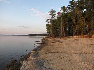
Jordan Lake State Recreation Area is a North Carolina state park spanning Chatham County, and Wake County, North Carolina. It comprises 4,558 acres (18.45 km2) of woodlands along the shores of 13,940-acre (56 km2) Jordan Lake.

<span class="mw-page-title-main">Lake Isabella</span> Reservoir in California, United States

Lake Isabella also called Isabella Lake, is a reservoir in Kern County, California, United States created by the earthen Isabella Dam. At 11,000 acres (4,500 ha), it is one of the larger reservoirs in California. Lake Isabella is located about 40 miles (64 km) northeast of Bakersfield, and is the main water supply for that city. It was formed in 1953 when the U.S. Army Corps of Engineers dammed the Kern River at the junction of its two forks. The area is in the southern end of the Sierra Nevada range and the lake itself is located in low mountains at an elevation of approximately 2,500 ft (760 m) where summer temperatures reach over 100 °F (38 °C) but low enough to avoid winter snows on the surrounding ridges. The former towns of Isabella and Kernville were flooded when the reservoir was created.

<span class="mw-page-title-main">Oroville Dam</span> Dam in California

Oroville Dam is an earthfill embankment dam on the Feather River east of the city of Oroville, California, in the Sierra Nevada foothills east of the Sacramento Valley. At 770 feet (235 m) high, it is the tallest dam in the U.S. and serves mainly for water supply, hydroelectricity generation, and flood control. The dam impounds Lake Oroville, the second-largest reservoir in California, capable of storing more than 3.5 million acre-feet (1.1×10^12 US gal; 4.3×10⁹ m3).

<span class="mw-page-title-main">Lake Allatoona</span> Reservoir in Georgia, United States

Lake Allatoona is a U.S. Army Corps of Engineers reservoir on the Etowah River in northwestern part of the State of Georgia. This reservoir is mostly in southeastern Bartow County and southwestern Cherokee County. A small portion is located in Cobb County near Acworth.

<span class="mw-page-title-main">Lake Lanier</span> Reservoir in Georgia, United States

Lake Lanier is a reservoir in the northern portion of the U.S. state of Georgia. It was created by the completion of Buford Dam on the Chattahoochee River in 1956, and is also fed by the waters of the Chestatee River. The lake encompasses 38,000 acres (15,000 ha) or 59 sq mi (150 km2) of water, and 692 mi (1,114 km) of shoreline at normal level, a "full pool" of 1,071 ft (326 m) above mean sea level and the exact shoreline varies by resolution according to the coastline paradox. Named for Confederate poet Sidney Lanier, it was built and is operated by the U.S. Army Corps of Engineers for flood control and water supplies. Its construction destroyed more than 50,000 acres (20,000 ha) of farmland and displaced more than 250 families, 15 businesses, and relocated 20 cemeteries along with their remains in the process.

<span class="mw-page-title-main">California Department of Water Resources</span>

The California Department of Water Resources (DWR) is part of the California Natural Resources Agency and is responsible for the management and regulation of the State of California's water usage. The department was created in 1956 by Governor Goodwin Knight following severe flooding across Northern California in 1955, where they combined the Division of Water Resources of the Department of Public Works with the State Engineer's Office, the Water Project Authority, and the State Water Resources Board. It is headquartered in Sacramento.

<span class="mw-page-title-main">Greers Ferry Lake</span> Reservoir in Arkansas, US

Greers Ferry Lake is the reservoir formed by Greers Ferry Dam, a United States Army Corps of Engineers dam in Northern Arkansas. It is located about 60 miles (100 km) north of Little Rock.

<span class="mw-page-title-main">New Hope Creek</span> Stream in North Carolina, USA

New Hope Creek is a watercourse that rises in rural Orange County, North Carolina, in the United States. It drains the western portion of Orange County and the southern half of Durham County and flows into the northern end of Jordan Lake reservoir. The drainage area encompasses urban, suburban and rural lands. Formerly the New Hope River, it was a tributary of the Cape Fear River until it was dammed to create Jordan Lake. Construction of the lake began in 1973, after a comprehensive study of regional water management by the U.S. Army Corps of Engineers, motivated by major flooding in a 1945 hurricane. Several communities draw drinking water from Jordan Lake, increasing interest in protection of the New Hope Creek watershed.

<span class="mw-page-title-main">Washington Suburban Sanitary Commission</span> Political subdivision of Maryland

The Washington Suburban Sanitary Commission is a bi-county political subdivision of the State of Maryland that provides safe drinking water and wastewater treatment for Montgomery and Prince George's Counties in Maryland except for a few cities in both counties that continue to operate their own water facilities.

<span class="mw-page-title-main">Isabella Dam</span> Dam in Kern County, California

Isabella Dam is an embankment dam located in the Kern River Valley, about halfway down the Kern River course, between the towns of Kernville and Lake Isabella in Kern County, California.

<span class="mw-page-title-main">New Hogan Lake</span> Reservoir in Calaveras County, California

New Hogan Lake is an artificial lake in the foothills of the Sierra Nevada in Calaveras County, California, about 30 miles (48.3 km) northeast of Stockton. It is formed by New Hogan Dam on the Calaveras River, whose North and South forks combine just upstream of the lake, and has a capacity of 317,000 acre⋅ft (391,000,000 m3). The earth-fill dam, completed in 1963, is 210 feet (64.0 m) high from the crest of the dam to the original streambed. The reservoir was first filled in 1965. There is a small hydroelectric plant at its base. It is owned by the United States Army Corps of Engineers and provides flood protection, drinking water, electricity and water for irrigation. There is also recreation available, such as boating, fishing, water skiing and camping.

<span class="mw-page-title-main">Canyon Lake (Texas)</span> Man-made reservoir in Texas, United States

Canyon Lake is a reservoir on the Guadalupe River in the Texas Hill Country in the United States. Canyon Lake is a U.S. Army Corps of Engineers reservoir formed on the Guadalupe River in Comal County by Canyon Dam, which is located about sixteen miles northwest of New Braunfels. The dam, lake, and all adjacent property are managed by the U.S. Army Corps Of Engineers. Water rights, waste water treatment, and hydroelectric generating facilities are managed by the Guadalupe-Blanco River Authority. Construction of the dam began in 1958 and was completed in 1964. The reservoir serves to provide flood control and water supply for the communities downstream from the dam. The lake is also a popular recreational destination.

Lake Michie is a reservoir in central North Carolina, within the Neuse River watershed. The lake is located in northern Durham County near the town of Bahama. Fed principally by the Flat River, Lake Michie is the primary reservoir for the city of Durham. The reservoir dam was completed in 1926.

<span class="mw-page-title-main">John Redmond Reservoir</span> Reservoir in Coffey County, Kansas

John Redmond Reservoir is a reservoir on the Neosho River in eastern Kansas. Built and managed by the U.S. Army Corps of Engineers, it is used for flood control, recreation, water supply, and wildlife management. It borders the Flint Hills National Wildlife Refuge to the northwest.

<span class="mw-page-title-main">Hunter Lake</span> Proposed reservoir in Illinois, US

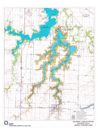
Hunter Lake is a proposed 2,649-acre (10.72 km2) reservoir to be created in Illinois, United States, by damming Horse Creek, a tributary of the Sangamon River. If the lake is built, its construction would flood a section of bottomland in southeastern Sangamon County, Illinois near the city of Springfield, between two other lakes, Lake Springfield and Lake Sangchris, to an elevation of 568.7 feet above sea level. See, http://supplementalwater.cwlp.com/Documents.aspx p. 2-22. The lake is a project of City Water, Light & Power, the local municipal electric utility.

<span class="mw-page-title-main">Patroon Creek</span> River in New York, United States

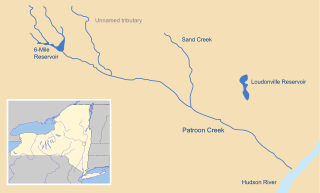
Patroon Creek is a stream in Albany County, New York, United States and is a tributary of the Hudson River which flows south to New York Harbor and the Atlantic Ocean. The creek's source is Rensselaer Lake in the western section of the city of Albany. Patroon Creek received its name from the patroon of Rensselaerswyck.

There are a large number of reservoirs in Wales reflecting the need for the supply of water for both industry and for consumption, both within the country itself and in neighbouring England. A number also provide hydroelectricity and many old reservoirs also provided motive power for industries, especially for the processing of minerals such as metal ores and slate.

References

  1. 1 2 3 4 5 6 7 8 9 US Army Corps of Engineers. "B Everett Jordan Dam and Lake". Brochure.
  2. Capehart, Al. "Durham to Duncan – Norfolk Southern" (PDF). Retrieved September 15, 2019.
  3. Taylor, Mike (March 5, 2024). "Unusually low reservoir levels reveal remnants of submerged town from 1980s: 'For years, these ruins have been virtually invisible'". Yahoo News. Retrieved March 5, 2024.
  4. https://files.nc.gov/ncdeq/Water%20Resources/files/permits/jordanlake/EMC_Final_Decision_Round_4_Jordan_Lake_Allocation_2017-04-04.pdf [ bare URL PDF ]
  5. https://files.nc.gov/ncdeq/Water%20Resources/files/permits/jordanlake/Revised_Jordan_Lake_Water_Supply_Allocation_Recommendations_20170310.pdf [ bare URL PDF ]
  6. Clean Jordan Lake
  7. "NCDENR DWR Permits & Registration » Jordan Lake Water Supply Allocation". Archived from the original on October 9, 2014. Retrieved November 26, 2014.
  8. NCDENR DWR Current Allocations
  9. NCDENR DWR Background
  10. Brief History of Jordan Nutrient Strategy
  11. NCDENR DWR Jordan Lake Rules
  12. Jordan Lake Rules fact sheet
  13. NCDENR - Read the Rules
  14. Using Circulators to Control Wastewater Pond Odors
  15. WRAL. "Elevated levels of unregulated chemicals found in Jordan Lake, Cary drinking water :: WRAL.com". WRAL.com. Retrieved March 8, 2018.
  16. News & Observer: Debris clogs Jordan Lake's coves Archived 2012-09-28 at the Wayback Machine
  17. "NBC 17: Volunteers Sought For Trash Removal In Jordan Lake". Archived from the original on April 9, 2009. Retrieved May 20, 2010.
  18. cleanjordanlake.org
  19. Independent Weekly: Jordan Lake: Turtles, herons and Styrofoam
  20. Curliss, J. Andrew (May 12, 2010). "Littered lake gets a cleanup". NewsObserver.com. Archived from the original on May 12, 2010. Retrieved November 25, 2018.
  21. NBC 17: Volunteers Wanted To Clean Up Jordan Lake
  22. "Archived copy" (PDF). Archived from the original (PDF) on October 23, 2017. Retrieved October 23, 2017.{{cite web}}: CS1 maint: archived copy as title (link)
  23. "Talking Trash: Fall 2014 by ACA | Canoe - Kayak - SUP - Raft - Rescue - Issuu". October 29, 2014.