Parkers Crossroads, Tennessee

Last updated

Parkers Crossroads, Tennessee
Henderson County Tennessee Incorporated and Unincorporated areas Parker's Crossroads Highlighted 4756870.svg
Location in Henderson County, Tennessee
Coordinates: 35°46′54″N88°23′22″W / 35.78167°N 88.38944°W / 35.78167; -88.38944
Country United States
State Tennessee
County Henderson
IncorporatedJune 2, 1981
Area
[1]
  Total3.79 sq mi (9.81 km2)
  Land3.79 sq mi (9.81 km2)
  Water0.00 sq mi (0.00 km2)
Elevation
522 ft (159 m)
Population
 (2020) [2]
  Total284
  Density75.01/sq mi (28.96/km2)
Time zone UTC-6 (Central (CST))
  Summer (DST) UTC-5 (CDT)
ZIP code
38388
FIPS code 47-56870 [3]
GNIS feature ID1652486 [4]
Website www.parkerscrossroad.org

Parkers Crossroads is a city in Henderson County, Tennessee, United States. The population was 330 as of the 2010 census, [5] up from 241 at the 2000 census.

Contents

Geography

Parkers Crossroads is located in northern Henderson County at 35°46′54″N88°23′22″W / 35.78167°N 88.38944°W / 35.78167; -88.38944 (35.781655, -88.389434). [6] It is bordered to the north by the town of Clarksburg in Carroll County. Interstate 40 crosses Tennessee State Route 22 at Exit 108 just south of the original crossroads. I-40 leads east 102 miles (164 km) to Nashville and west 110 miles (180 km) to Memphis, while SR 22 leads north 16 miles (26 km) to Huntingdon and south 9 miles (14 km) to Lexington, the Henderson county seat.

According to the United States Census Bureau, Parkers Crossroads has a total area of 3.7 square miles (9.6 km2), all land. [5]

Demographics

Historical population
CensusPop.Note
1990 161
2000 24149.7%
2010 33036.9%
2020 284−13.9%
Sources: [7] [8] [2]

As of the census [3] of 2000, there were 241 people, 107 households, and 80 families residing in the city. The population density was 164.8 inhabitants per square mile (63.6/km2). There were 111 housing units at an average density of 75.9 per square mile (29.3/km2). The racial makeup of the city was 80.91% White, 14.52% African American, 3.32% from other races, and 1.24% from two or more races. Hispanic or Latino of any race were 1.24% of the population.

There were 107 households, out of which 21.5% had children under the age of 18 living with them, 63.6% were married couples living together, 9.3% had a female householder with no husband present, and 25.2% were non-families. 24.3% of all households were made up of individuals, and 8.4% had someone living alone who was 65 years of age or older. The average household size was 2.25 and the average family size was 2.61.

In the city, the population was spread out, with 17.0% under the age of 18, 7.1% from 18 to 24, 30.7% from 25 to 44, 28.6% from 45 to 64, and 16.6% who were 65 years of age or older. The median age was 42 years. For every 100 females, there were 104.2 males. For every 100 females age 18 and over, there were 108.3 males.

The median income for a household in the city was $24,792, and the median income for a family was $35,625. Males had a median income of $36,875 versus $21,250 for females. The per capita income for the city was $17,303. About 19.0% of families and 18.7% of the population were below the poverty line, including 12.5% of those under the age of eighteen and 21.6% of those 65 or over.

Transportation

Parkers Crossroads is located off Interstate 40 exit 108. Tennessee State Route 22 is the main road through the city.

See also

Notable person

Related Research Articles

<span class="mw-page-title-main">Henderson County, Tennessee</span> County in Tennessee, United States

Henderson County is a county located in the U.S. state of Tennessee. As of the 2020 census, the population was 27,842. Its county seat is Lexington. The county was founded in 1821 and named for James Henderson, a soldier in the War of 1812.

<span class="mw-page-title-main">Chester County, Tennessee</span> County in Tennessee, United States

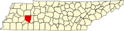
Chester County is a county located in the U.S. state of Tennessee. As of the 2020 census, the population was 17,341. Its county seat is Henderson. The county was created in 1879 and organized in 1882. Chester County is included in the Jackson, TN Metropolitan Statistical Area.

<span class="mw-page-title-main">Whitley City, Kentucky</span> Census-designated place in Kentucky, United States

Whitley City is an unincorporated community and census-designated place (CDP) in McCreary County, Kentucky, United States. The population was 968 at the 2020 census, down from 1,170 in 2010. It is the county seat of McCreary County. Whitley City is one of two unincorporated county seats in Kentucky.

<span class="mw-page-title-main">Clarksburg, Tennessee</span> Town in Tennessee, United States

Clarksburg is a town in Carroll County, Tennessee, United States. The population was 393 at the 2010 census. Clarksburg has its own high school.

<span class="mw-page-title-main">Henderson, Tennessee</span> City in Tennessee, United States

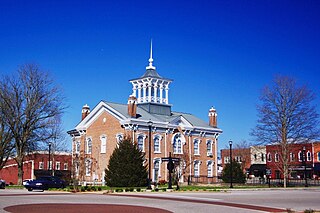
Henderson is a city in and the county seat of Chester County, Tennessee, United States. The population was 6,309 at the 2010 census, up from 5,670 at the 2000 census.

<span class="mw-page-title-main">Manchester, Tennessee</span> City in Tennessee, United States

Manchester is a city in Coffee County, Tennessee, United States. The population was 12,213 at the 2020 census. It is the county seat of Coffee County. The city is located halfway between Nashville and Chattanooga on Interstate 24.

<span class="mw-page-title-main">Parsons, Tennessee</span> City in Tennessee, United States

Parsons is a city in Decatur County, Tennessee, United States. The population was 2,373 at the 2010 census. Parsons is the largest city by population in Decatur County.

<span class="mw-page-title-main">Middleton, Tennessee</span> City in Tennessee, United States

Middleton is a city in Hardeman County, Tennessee, United States. The population was 706 at the 2010 census, up from 602 at the 2000 census. It is located at the intersection of Tennessee State Route 125 and Tennessee State Route 57. Its slogan is the "Crossroads of the South".

<span class="mw-page-title-main">Toone, Tennessee</span> Town in Tennessee, United States

Toone is a town in Hardeman County, Tennessee, United States. The population was 364 at the 2010 census.

<span class="mw-page-title-main">Crump, Tennessee</span> City in Tennessee, United States

Crump is a city in Hardin County, Tennessee, United States. The population was 1,428 at the 2010 census, and 1,594 at the 2020 census.

<span class="mw-page-title-main">Savannah, Tennessee</span> City in Tennessee, United States

Savannah is a city in and the county seat of Hardin County, Tennessee, United States. The population was 7,213 at the 2020 census. Savannah is located along the east side of the Tennessee River.

<span class="mw-page-title-main">Lexington, Tennessee</span> City in Tennessee, United States

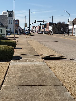
Lexington is a city in Henderson County, Tennessee, United States. Lexington is midway between Memphis and Nashville, lying 10 miles (16 km) south of Interstate 40, which connects the two cities. The population was 7,956 at the 2020 census. It is the county seat of Henderson County.

<span class="mw-page-title-main">Sardis, Tennessee</span> Town in Tennessee, United States

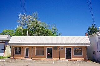
Sardis is a town in Henderson County, Tennessee, United States. The population was 381 at the 2010 census.

<span class="mw-page-title-main">Powells Crossroads, Tennessee</span> Town in Tennessee, United States

Powells Crossroads is a town in Marion County, Tennessee, United States. The population was 1,322 at the 2010 census, up from 1,286 in 2000. It is part of the Chattanooga, TN-GA Metropolitan Statistical Area.

<span class="mw-page-title-main">Dover, Tennessee</span> City in Tennessee, United States

Dover is a city in and the county seat of Stewart County, Tennessee, 67 miles (108 km) west-northwest of Nashville on the Cumberland River. Fort Donelson National Cemetery is in Dover. The population was 1,442 at the 2000 census and the 2010 census showed a population of 1,417.

<span class="mw-page-title-main">Fairfield, Texas</span> City in Texas, United States

Fairfield is a city and county seat of Freestone County, Texas, United States. The population was 2,850 at the 2020 census, down from 3,094 at the 2000 census. It was founded in 1851.

<span class="mw-page-title-main">McKenzie, Tennessee</span> City in Tennessee, United States

McKenzie is a city at the tripoint of Carroll, Henry, and Weakley counties in Tennessee, United States. The population was 5,310 at the 2010 census.

<span class="mw-page-title-main">Silerton, Tennessee</span> Town in Tennessee, United States

Silerton is a town in Hardeman and Chester counties in the western part of Tennessee. The population was 111 at the 2010 census.

<span class="mw-page-title-main">Scotts Hill, Tennessee</span> Town in Tennessee, United States

Scotts Hill is a town in Decatur and Henderson counties in the U.S. state of Tennessee. The population was 877 at the 2020 census.

<span class="mw-page-title-main">Humboldt, Tennessee</span> City in Tennessee, United States

Humboldt is a city in Gibson and Madison counties, Tennessee. The population was 8,452 at the 2010 census, a decline of 1,015 from 2000. It is the principal city of and is included in the Humboldt, Tennessee Micropolitan Statistical Area, which is included in the Jackson, Tennessee-Humboldt, Tennessee Combined Statistical Area.

References

  1. "ArcGIS REST Services Directory". United States Census Bureau. Retrieved October 15, 2022.
  2. 1 2 "Census Population API". United States Census Bureau. Retrieved October 15, 2022.
  3. 1 2 "U.S. Census website". United States Census Bureau . Retrieved January 31, 2008.
  4. "US Board on Geographic Names". United States Geological Survey. October 25, 2007. Retrieved January 31, 2008.
  5. 1 2 "Geographic Identifiers: 2010 Census Summary File 1 (G001): Parker's Crossroads city, Tennessee". American Factfinder. U.S. Census Bureau. Archived from the original on February 13, 2020. Retrieved February 1, 2018.
  6. "US Gazetteer files: 2010, 2000, and 1990". United States Census Bureau. February 12, 2011. Retrieved April 23, 2011.
  7. "Census of Population and Housing: Decennial Censuses". United States Census Bureau . Retrieved March 4, 2012.
  8. "Incorporated Places and Minor Civil Divisions Datasets: Subcounty Resident Population Estimates: April 1, 2010 to July 1, 2012". Population Estimates. U.S. Census Bureau. Archived from the original on June 11, 2013. Retrieved December 11, 2013.