Related Research Articles

The Nez Perce are an Indigenous people of the Plateau who still live on a fraction of the lands on the southeastern Columbia River Plateau in the Pacific Northwest. This region has been occupied for at least 11,500 years.

Garfield County is a county located in the U.S. state of Washington. As of the 2020 census, the population was 2,286, making it the least populous county in Washington; with about 3.2 inhabitants per square mile (1.2/km2), it is also the least densely populated county in Washington. The county seat and only city is Pomeroy.

Asotin County is a county in the U.S. state of Washington. As of the 2020 census, the population was 22,285. The county seat is at Asotin, and its largest city is Clarkston. The county was created out of Garfield County in 1883 and derives its name from a Nez Perce word meaning "Eel Creek." Asotin County is part of the Lewiston–Clarkston metropolitan area, which includes Nez Perce County, Idaho, and Asotin County.

Kamiah is a city in Lewis and Idaho counties in the U.S. state of Idaho. The largest city in Lewis County, it extends only a small distance into Idaho County, south of Lawyer Creek. The population was 1,295 at the 2010 census, up from 1,160 in 2000. The city lies in the narrow valley of the Clearwater River; downstream are Orofino and Lewiston, at the confluence with the Snake River.
Craigmont is a city in the northwest United States in Lewis County, Idaho. Located on the Camas Prairie in north central Idaho, it is within the Nez Perce Indian Reservation. The population was 501 at the 2010 census, down from 556 in 2000.

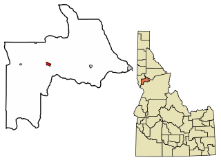
Pomeroy is a city in Garfield County, Washington, United States. The population was 1,425 at the 2010 census. It is the county seat of and only incorporated city in Garfield County.
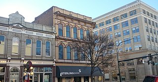
Walla Walla is a city in Walla Walla County, Washington, where it is the largest city and county seat. It had a population of 34,060 at the 2020 census, estimated to have decreased to 33,927 as of 2021. The population of the city and its two suburbs, the town of College Place and unincorporated Walla Walla East, is about 45,000.

Wallula is a census-designated place (CDP) in Walla Walla County, Washington, United States. The population was 179 at the 2010 census.

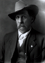
Hin-mah-too-yah-lat-kekt, popularly known as Chief Joseph, Young Joseph, or Joseph the Younger, was a leader of the wal-lam-wat-kain (Wallowa) band of Nez Perce, a Native American tribe of the interior Pacific Northwest region of the United States, in the latter half of the 19th century. He succeeded his father tuekakas in the early 1870s.

The Walla Walla River is a tributary of the Columbia River, joining the Columbia just above Wallula Gap in southeastern Washington in the United States. The river flows through Umatilla County, Oregon, and Walla Walla County, Washington. Its drainage basin is 1,758 square miles (4,550 km2) in area.

The Battle of the Big Hole was fought in Montana Territory, August 9–10, 1877, between the United States Army and the Nez Perce tribe of Native Americans during the Nez Perce War. Both sides suffered heavy casualties. The Nez Perce withdrew in good order from the battlefield and continued their long fighting retreat that would result in their attempt to reach Canada and asylum.
Joseph Goff Gale was an American pioneer, trapper, entrepreneur, and politician who contributed to the early settlement of the Oregon Country. There he assisted in the construction of the first sailing vessel built in what would become the state of Oregon, sailed the ship to California to trade for cattle, and later served as one of three co-executives ("governors") in the Provisional Government of Oregon. Originally a sailor, he also spent time in the fur trade, as a farmer, and a gold miner in the California Gold Rush.
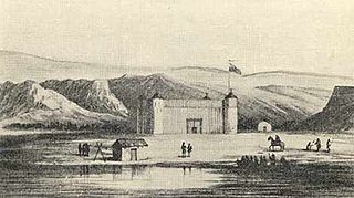
Fort Nez Percés, later known as (Old) Fort Walla Walla, was a fortified fur trading post on the Columbia River on the territory of modern-day Wallula, Washington. Despite being named after the Nez Perce people, the fort was in the traditional lands of the Walla Walla. Founded in 1818 by the North-West Company, after 1821 it was run by the Hudson's Bay Company until its closure in 1857.
The Touchet River is a 55-mile (89 km) tributary of the Walla Walla River in southeastern Washington in the United States. The Touchet River drains an area of about 740 square miles (1,900 km2) in Columbia County and Walla Walla County.

The Tucannon River is a tributary of the Snake River in the U.S. state of Washington. It flows generally northwest from headwaters in the Blue Mountains of southeastern Washington to meet the Snake 4 miles (6 km) upstream from Lyons Ferry Park and the mouth of the Palouse River. The Tucannon is about 62 miles (100 km) long. Part of the upper river flows through the Wenaha–Tucannon Wilderness.
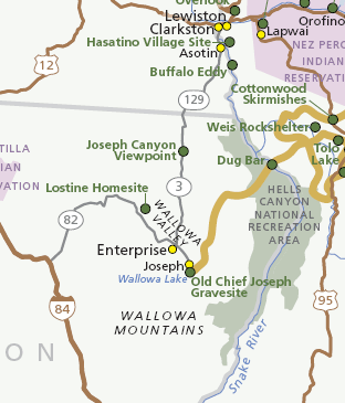
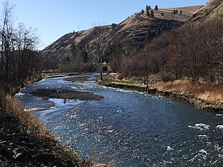
Joseph Canyon is a 2,000-foot (610 m)-deep basalt canyon in northern Wallowa County, Oregon, and southern Asotin County, Washington, United States.
The Grande Ronde Valley is a valley in Union County in northeastern Oregon, United States. It is surrounded by the Blue Mountains, and is drained by the Grande Ronde River. La Grande is its largest community. The valley is 35 miles (56 km) long, north to south, from Pumpkin Ridge to Pyles Canyon, and 15 miles (24 km) wide, east to west, from Cove to the Grande Ronde River's canyon. Its name, fittingly, means, "great circle."
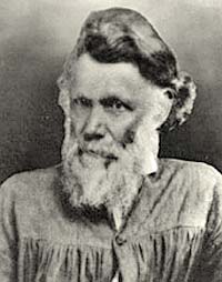
Lucullus Virgil McWhorter was an American farmer and frontiersman who documented the historical Native American tribes in West Virginia and the modern-day Plateau Native Americans in Washington state. After living in West Virginia and Ohio, in 1903 he moved to the frontier of Yakima, Washington, in the eastern part of the state. He became a rancher and activist, learning much from his Yakama Nation neighbors and becoming an activist for them. In 1914 he was adopted as an honorary member of the Yakama, after helping over several years to defeat a federal bill that would have required them to give up much of their land in order to get any irrigation rights. They named him Hemene Ka-Wan,, meaning Old Wolf.

Almota is an extinct town in Whitman County, in the U.S. state of Washington. The GNIS classifies it as a populated place.
The history of Walla Walla, Washington begins with the settling of Oregon Country, Fort Nez Percés, the Whitman Mission and Walla Walla County, Washington.
References
- ↑ "Patahaflourmills". Archived from the original on January 4, 2018. Retrieved January 3, 2018.
- ↑ "Garfield County -- Thumbnail History".
- ↑ "Garfield co. Geography".
- ↑ "History and Geographical Details of Pomeroy Washington from the Downtown Historic Preservation Committee".
- ↑ Pierce, Virginia (November 10, 1971). "Venerable courthouse still in use". Spokane Daily Chronicle. pp. 4B. Retrieved November 2, 2015.
Municipalities and communities of Garfield County, Washington, United States | ||
|---|---|---|
| City |  | |
| CDP | ||
| Other communities | ||
| Ghost town | ||
46°28′22″N117°32′20″W / 46.472803°N 117.538819°W
| | This Garfield County, Washington state location article is a stub. You can help Wikipedia by expanding it. |