
Patrick Meier invented the concept of using crisis mapping in humanitarian emergencies, and is a co-founder and the Executive Director of WeRobotics. [1]
Patrick Meier invented the concept of using crisis mapping in humanitarian emergencies, and is a co-founder and the Executive Director of WeRobotics. [1]
The son of a businessman, Meier grew up in Kenya, Ivory Coast, and Austria. [1]
As a 13-year old in Kenya, Meier created an online map of Iraq during the 1991 Gulf War. [1]
Meier received his undergraduate degree from Tufts University, [1] and studies for his Ph.D. at Tuffs University's Fletcher School. [2]
Meier's fiancée was in Port-au-Prince when the 2010 Haiti earthquake occurred. [2] [3] Working remotely, Meier invented the concept of a crisis map by creating an online digital map to help with the coordination of humanitarian assistance. Thousands of people in forty countries pulled information from YouTube, Facebook, and Twitter as well as email, videos and text messages, and input it on the online map. [2] [1] [4] The crisis map was used by United States Marine Corps, and the United States Federal Emergency Management Agency. [1]

Meier worked at the Harvard Humanitarian Initiative [1] and is the director of social innovation at the Qatar Computing Research Institute. [5]
In November 2013, Meier aided the United Nations response to Typhoon Haiyan in the Philippines. [6] [7] Later he criticized humanitarian drone operators for not sharing the information they had gathered with either local authorities or humanitarian agencies, and spoke of the need for a code of conduct. [7]
In March 2014, Meier led a process to update the UAV Code of Conduct. [8] [6]
In February 2015, Meier was a judge in a Dubai based Drones for Good competition. [9]
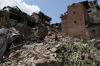
In the aftermath of the 2015 Nepal earthquakes, Meier used unmanned aerial vehicles to create detailed images of Kathmandu. [1] Speaking later in 2015, he accused many humanitarian drone operators of "causing more harm than good", [10] and spoke of importance of the drone code of conduct. [11]
In 2016, Meier was contacted by authorities in Ecuador who were seeking advice about how to respond to the 2016 Ecuador earthquake. [12]
Meier is a co-founder of WeRobotics, [1] [13] the founder of the Humanitarian UAV Network (also known as UAViators), and a co-founder of Kathmandu Flying Labs. [10]
Meier co-founded the Digital Humanitarian Network with United Nations official Andrej Verity. [1]
Meier is the author of the book Digital Humanitarians . [14] [2]
Meier married Christine Martin in 2013, with whom he has a child. [1] They live in Washington, D.C. [1]

An unmanned aerial vehicle (UAV), commonly known as a drone, is an aircraft without any human pilot, crew, or passengers on board. UAVs were originally developed through the twentieth century for military missions too "dull, dirty or dangerous" for humans, and by the twenty-first, they had become essential assets to most militaries. As control technologies improved and costs fell, their use expanded to many non-military applications. These include aerial photography, precision agriculture, forest fire monitoring, river monitoring, environmental monitoring, policing and surveillance, infrastructure inspections, smuggling, product deliveries, entertainment, and drone racing.

Humanitarianism is an active belief in the value of human life, whereby humans practice benevolent treatment and provide assistance to other humans to reduce suffering and improve the conditions of humanity for moral, altruistic, and emotional reasons. One aspect involves voluntary emergency aid overlapping with human rights advocacy, actions taken by governments, development assistance, and domestic philanthropy. Other critical issues include correlation with religious beliefs, motivation of aid between altruism and social control, market affinity, imperialism and neo-colonialism, gender and class relations, and humanitarian agencies. A practitioner is known as a humanitarian.

Disaster response refers to the actions taken directly before, during or in the immediate aftermath of a disaster. The objective is to save lives, ensure health and safety and to meet the subsistence needs of the people affected. This includes warning/evacuation, search and rescue, providing immediate assistance, assessing damage, continuing assistance and the immediate restoration or construction of infrastructure. The aim of emergency response is to provide immediate assistance to maintain life, improve health and support the morale of the affected population. Such assistance may range from providing specific but limited aid, such as assisting refugees with transport, temporary shelter, and food to establishing semi-permanent settlements in camps and other locations. It also may involve initial repairs to damage or diversion to infrastructure.
Ushahidi is an open source software application which utilises user-generated reports to collate and map data. It uses the concept of crowdsourcing serving as an initial model for what has been coined as "activist mapping" – the combination of social activism, citizen journalism and geographic information. Ushahidi allows local observers to submit reports using their mobile phones or the Internet, creating an archive of events with geographic and time-date information. The Ushahidi platform is often used for crisis response, human rights reporting, and election monitoring. Ushahidi was created in the aftermath of Kenya's disputed 2007 presidential election that collected eyewitness reports of violence reported by email and text message and placed them on a Google Maps map.

The response to the 2010 Haiti earthquake included national governments, charitable and for-profit organizations from around the world which began coordinating humanitarian aid designed to help the Haitian people. Some countries arranged to send relief and rescue workers and humanitarian supplies directly to the earthquake damage zones, while others sought to organize national fund raising to provide monetary support for the nonprofit groups working directly in Haiti. OCHA coordinates and tracks this on a daily basis. The information is disseminated through the UN news and information portal, ReliefWeb. As of September 5, 2013, ReliefWeb have reported a total relief funding of $3.5 billion given.
Google Crisis Response is a team within Google.org that "seeks to make critical information more accessible around natural disasters and humanitarian crises". The team has responded in the past to the 2010 Haiti earthquake, 2010 Pakistan floods, 2010–11 Queensland floods, February 2011 Christchurch earthquake, and the 2011 Tōhoku earthquake and tsunami among other events, using Google resources and tools such as Google Maps, Google Earth, Google Person Finder, and Google Fusion Tables.
Relief 2.0 or disaster relief 2.0 is the deployment of digital information techniques in the management of disaster relief.

Burners Without Borders (BWB) is a community-led NGO which initiates civic works projects and disaster relief in local communities around the globe.

Crisis mapping is the real-time gathering, display and analysis of data during a crisis, usually a natural disaster or social/political conflict. Crisis mapping projects usually allows large numbers of people, including the public and crisis responders, to contribute information either remotely or from the site of the crisis. One benefit of the crisis mapping method over others is that it can increase situational awareness, since the public can report information and improve data management.

The Digital Humanitarian Network is a consortium allowing Volunteer and Technical Communities (V&TCs) to interface with humanitarian organizations that seek their services.
Sahana Software Foundation is a Los Angeles, California-based non-profit organization founded to promote free and open-source software (FOSS) for disaster and emergency management. The foundation's mission statement is to "save lives by providing information management solutions that enable organizations and communities to better prepare for and respond to disasters." The foundation's Sahana family of software products includes Eden, designed for humanitarian needs management; Vesuvius, focused on the disaster preparedness needs of the medical community; and legacy earlier versions of Sahana software including Krakatoa, descended from the original Sahana code base developed following the 2004 Indian Ocean tsunami. The word "Sahana" means "relief" in Sinhalese, one of two national languages of Sri Lanka.
The April 2015 Nepal earthquake killed 8,964 people and injured 21,952 more. It occurred at on Saturday, 25 April 2015, with a magnitude of 7.8Mw or 8.1Ms and a maximum Mercalli Intensity of X (Extreme). Its epicenter was east of Gorkha District at Barpak, Gorkha, roughly 85 km (53 mi) northwest of central Kathmandu, and its hypocenter was at a depth of approximately 8.2 km (5.1 mi). It was the worst natural disaster to strike Nepal since the 1934 Nepal–Bihar earthquake. The ground motion recorded in Kathmandu, the capital of Nepal, was of low frequency, which, along with its occurrence at an hour when many people in rural areas were working outdoors, decreased the loss of property and human lives.
An earthquake struck Nepal at 11:56:54 NST on 25 April 2015 with a moment magnitude of 7.8 and a maximum Mercalli intensity of IX (Violent). It was the most powerful earthquake to strike Nepal since the 1934 Nepal–Bihar earthquake. Many thousands of people died, with most casualties reported in Nepal, and adjoining areas of India, China, and Bangladesh.
Crowdmapping is a subtype of crowdsourcing by which aggregation of crowd-generated inputs such as captured communications and social media feeds are combined with geographic data to create a digital map that is as up-to-date as possible on events such as wars, humanitarian crises, crime, elections, or natural disasters. Such maps are typically created collaboratively by people coming together over the Internet.
Kathmandu Living Labs (KLL) is a living lab and nonprofit civic technology company based in Kathmandu, Nepal that primarily works on mobile technology and mapping. KLL focuses on using GPS/GIS technology for humanitarian aims, sometimes referred to as "humanitarian mapping".
Field Ready is a non-profit, global humanitarian aid and development, non governmental organization that helps provide critical items and training to people when they are in need of them.
WeRobotics is a not-for-profit organization that uses drones for humanitarian purposes.

Digital Humanitarians: How Big Data is changing the face of humanitarian response is a 2015 book by Patrick Meier.

Humanitarian dron refers to the use of unmanned aerial vehicles (UAVs) for humanitarian purposes. The term is broadly used to describe the use of drones in disaster relief, search and rescue operations, medical deliveries, and environmental protection, among other applications.