Pattani, Thailand

Last updated
Pattani
ปัตตานี
เทศบาลเมืองปัตตานี
Anoru, Mueang Pattani District, Pattani 94000, Thailand - panoramio (1).jpg
Pattani
Seal of Pattani.png
Nickname: 
Tani
Amphoe 9401.png
Location of Mueang Pattani district (red) in Pattani Province (Pattani town is located within Mueang Pattani district.)
Thailand adm location map.svg
Red pog.svg
Pattani
Location in Thailand
Coordinates: 6°51′59″N101°15′3″E / 6.86639°N 101.25083°E / 6.86639; 101.25083
Country Thailand
Province Pattani
District Mueang Pattani
Government
  MayorPitak Korkiatpitak
Area
   Town 4.78 km2 (1.85 sq mi)
  Metro
96.86 km2 (37.40 sq mi)
Population
 (2018)
   Town 44,353
  Density9,300/km2 (24,000/sq mi)
Time zone UTC+7 (ICT)
Area code (+66) 73
Website pattanicity.go.th

Pattani is a town ( thesaban mueang ) in the far south of Thailand, near the border with Malaysia. It is the capital of Pattani Province. The city has a population of 44,353 (2018). It covers the whole tambon Sabarang, Anoru and Chabang Tiko of Mueang Pattani district.

Contents

Pattani lies 1,056 km south of Bangkok, [1] and is located at the mouth of the Pattani River. The historic centre of Patani was originally located a few miles away near the Krue Se Mosque, but developed at the present location after the older Patani was captured and sacked in 1785.

The local dialect of Malay is called Pattani Malay or Yawi in Thai (derived from Jawi).

Etymology

Some believe that the name Pattani originated from Malay name Patani (Jawi: ڤطاني), which can mean "this beach" in Pattani Malay language. (In standard Malay, this would be pantai ini.) According to a legend, the founder of Pattani was a raja from Kota Malikha named Phaya Tunakpa. Phaya Tunakpa went hunting one day and saw a beautiful albino mouse-deer the size of a goat, which then disappeared. He asked his men where the animal had gone, and they replied: "Pata ning lah!" ("This beach!" in the Pattani Malay language). They searched for the mouse-deer but found instead an old couple, where the old man identified himself as Che' Tani ("Mister Tani"). The old man said that he was sent by the raja's grandfather to build a new town further beyond but had fallen ill on the journey; as he could not go any further, he stayed at that place. The raja then ordered a town be built at the site where the mouse-deer had disappeared. The town became Patani, which is believed to be named either after "this beach" where the mouse-deer had disappeared. Alternatively, it has also been said to be named after the old man as Pak Tani meaning "Father Tani". [2]

Some also say the word Pattani is derived from "Petani" in Malay which means "farmer". Another suggestion is that it derives from a Sanskrit word pathini, meaning "virgin nymph"; Pathini is also said to be the title of a daughter of Merong Mahawangsa, founder of the preceding kingdom of Langkasuka. [3]

History

Pattani is located at the mouth of the Pattani River. The river may have changed course and empty into the sea at the current location in the 16th century. A small port existed in the current location at Kuala Bekah at the mouth of Sungai Patani by the early 17th century. [4] However, the older historical centre of the Pattani Kingdom that ruled over the region of Patani was located a 67 km to the east of the present city; near Ban Kru Se or Kampong Kersik, which is where the Krue Se Mosque is located. [5] The older Pattani was captured and sacked by the Siamese, and a new town centre later developed in the current location and the Sultan moved to Cabang Tiga at the southern side of present-day Pattani in the 19th century. The Patani City municipality was established in 1935 by royal decree. [6] [7]

Climate

Pattani has a tropical monsoon climate according to the Köppen climate classification, with a lengthy wet season and a brief dry season. The temperatures and humidity are high year round, with slightly higher temperatures in April, just as the monsoon arrives. The wet season is long, lasting May-December, and the dry season short, covering only January-April. The months of October, November, and December are particularly wet.

Climate data for Pattani (1991–2020)
MonthJanFebMarAprMayJunJulAugSepOctNovDecYear
Record high °C (°F)34.3
(93.7)
35.9
(96.6)
37.0
(98.6)
37.9
(100.2)
38.0
(100.4)
36.6
(97.9)
36.3
(97.3)
35.8
(96.4)
36.0
(96.8)
35.0
(95.0)
34.0
(93.2)
33.9
(93.0)
38.0
(100.4)
Average high °C (°F)31.1
(88.0)
32.3
(90.1)
33.5
(92.3)
34.3
(93.7)
34.1
(93.4)
33.5
(92.3)
33.3
(91.9)
33.2
(91.8)
32.7
(90.9)
32.0
(89.6)
30.7
(87.3)
30.1
(86.2)
32.57
(90.63)
Daily mean °C (°F)26.3
(79.3)
26.7
(80.1)
27.5
(81.5)
28.4
(83.1)
28.5
(83.3)
28.1
(82.6)
27.8
(82.0)
27.7
(81.9)
27.4
(81.3)
27.0
(80.6)
26.6
(79.9)
26.2
(79.2)
27.35
(81.23)
Average low °C (°F)22.7
(72.9)
22.4
(72.3)
23.0
(73.4)
24.0
(75.2)
24.5
(76.1)
24.3
(75.7)
24.0
(75.2)
23.9
(75.0)
23.9
(75.0)
23.9
(75.0)
23.8
(74.8)
23.3
(73.9)
23.64
(74.55)
Record low °C (°F)18.6
(65.5)
16.7
(62.1)
18.5
(65.3)
17.4
(63.3)
21.6
(70.9)
20.6
(69.1)
20.4
(68.7)
21.0
(69.8)
20.8
(69.4)
21.3
(70.3)
21.0
(69.8)
19.7
(67.5)
16.7
(62.1)
Average precipitation mm (inches)94.2
(3.71)
36.2
(1.43)
54.1
(2.13)
83.2
(3.28)
133.9
(5.27)
118.7
(4.67)
128.8
(5.07)
147.0
(5.79)
140.8
(5.54)
221.8
(8.73)
400.5
(15.77)
392.8
(15.46)
1,952
(76.9)
Average precipitation days (≥ 0.1 mm)6.22.44.75.910.59.89.510.311.715.418.515.3120.2
Average relative humidity (%)8.081.678.978.678.279.379.879.580.983.886.585.681.0
Mean monthly sunshine hours 145.7166.7148.8144.0114.7111.0114.7114.7108.0111.6105.0108.51,493.4
Mean daily sunshine hours 4.75.94.84.83.73.73.73.73.63.63.53.54.1
Source 1: World Meteorological Organization [8]
Source 2: Office of Water Management and Hydrology, Royal Irrigation Department (sun 1981–2010) [9] (extremes) [10]

Related Research Articles

<span class="mw-page-title-main">Pattani province</span> Province of Thailand

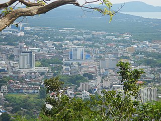
Pattani is one of the southern provinces of Thailand. Neighboring provinces are Narathiwat, Yala, and Songkhla. Its capital is the town of Pattani.

<span class="mw-page-title-main">Narathiwat province</span> Province of Thailand

Narathiwat is one of the southern provinces (changwat) of Thailand. Neighboring provinces are Yala and Pattani. To the south it borders the Malaysian state of Kelantan and Perak. The southern railway line ends in this province, which is one of the nation's four provinces that border Malaysia. The province features a range of cultures as well as natural resources, and is relatively fertile. Narathiwat is about 1,140 kilometers south of Bangkok and has an area of 4,475 km2 (1,728 sq mi). Seventy-five percent of the area is jungle and mountains and has a tropical climate.

<span class="mw-page-title-main">Yala province</span> Province of Thailand

Yala is the southernmost Province (changwat) of Thailand. Neighboring provinces are Songkhla, Pattani, and Narathiwat. Yala is one of two landlocked provinces in southern Thailand, the other being Phatthalung. Its southern part borders Kedah and Perak of Malaysia.

<span class="mw-page-title-main">Patani (historical region)</span> Historical region of the northern Malay Peninsula

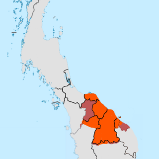
PataniDarussalam is a historical region and sultanate in the Malay peninsula. It includes the southern Thai provinces of Pattani, Yala (Jala), Narathiwat (Menara), and parts of Songkhla (Singgora). Its capital was the town of Patani.

<span class="mw-page-title-main">Songkhla</span> City in Thailand

Songkhla, also known as Singgora or Singora, is a city in Songkhla Province of southern Thailand, near the border with Malaysia. Songkhla lies 968 km (601 mi) south of Bangkok and as of 2020 had a population of 61,758.

<span class="mw-page-title-main">Sungai Petani</span> Town and district capital in Kedah, Malaysia

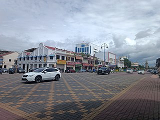
Sungai Petani is a city in Kuala Muda District, Kedah, Malaysia. Sungai Petani is Kedah's largest city and is located about 55 km south of Alor Setar, the capital of Kedah, and 33 km northeast of George Town, the capital city of the neighbouring state of Penang.

<span class="mw-page-title-main">Patani Kingdom</span> 1457(?)–1902 Malay sultanate in the northern Malay Peninsula

Patani, or the Sultanate of Patani was a Malay sultanate in the historical Pattani Region. It covered approximately the area of the modern Thai provinces of Pattani, Yala, Narathiwat and part of the northern modern-day Malaysian state of Kelantan. The 2nd–15th century state of Langkasuka and 6–7th century state of Pan Pan may or may not have been related.

<span class="mw-page-title-main">Satun</span> Town in Thailand

Satun is a town in southern Thailand, capital of the Satun province. It covers the whole tambon Phiman of Mueang Satun. Satun lies 985 km south of Bangkok. As of 2005 it has a population of 21,498.

<span class="mw-page-title-main">Rayong</span> City Municipality in Thailand

Rayong is a city on the east coast of the Gulf of Thailand and the capital of Rayong province. It covers tambons Tha Pradu and Pak Nam and parts of tambons Choeng Noen and Noen Phra, all within Mueang Rayong district. As of 2016 the population was 64,256 (est.). The main industry is fishing, and it is also the main producer of Thailand's fish sauce. It is also the center of the chemical and auto industries. In 2012 Ford Motor Company opened an assembly plant in Rayong to expand Ford's presence in the ASEAN area, employing some 2,200 people.

<span class="mw-page-title-main">Kelantan-Pattani Malay</span> Austronesian language

Kelantan-Pattani Malay is an Austronesian language of the Malayic subfamily spoken in the Malaysian state Kelantan, Besut and Setiu in Terengganu, and the southernmost provinces of Thailand. It is the primary spoken language of Thai Malays, but is also used as a lingua franca by ethnic Southern Thais in rural areas, Muslim and non-Muslim and the Sam-Sam, a mostly Thai-speaking population of mixed Malay and Thai ancestry.

<span class="mw-page-title-main">Phaya Tani</span>

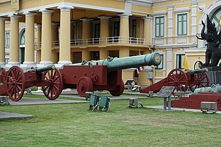
Phaya Tani is a 17th-century siege cannon from Pattani Province in southern Thailand. It is the largest cannon ever cast in what is now Thailand, measuring 2.7 m long and made of brass. It is on display in front of the Ministry of Defence, opposite the Grand Palace in Bangkok. The cannon still serves as the symbol of Pattani Province and it has been on the official seal of Pattani Province since 1939.

Pattani may refer to:

<span class="mw-page-title-main">Raman district</span> District in Yala, Thailand

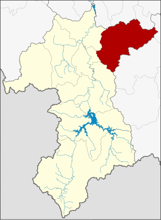
Raman is a district (amphoe) in the northeastern part of Yala province, southern Thailand.

Pattani River is a river in southern Thailand. It originates in Betong district, Yala Province and empties into the Gulf of Thailand at the town of Pattani. Within Yala Province the river forms the Bang Lang Reservoir. The river is 214 kilometres (133 mi) long.

<span class="mw-page-title-main">Krue Se Mosque</span>

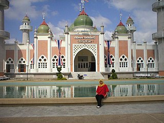
Krue Se Mosque also called Gresik Mosque, Pitu Krue-ban Mosque or Sultan Muzaffar Shah Mosque, is a mosque in Pattani Province, Thailand. Its construction may have begun in the 16th century. The surviving structure features a mixture of Middle Eastern and European architectural styles.

<span class="mw-page-title-main">Phuket (city)</span> City in Thailand

Lin Daoqian, also written as Lim Toh Khiam and Vintoquián, was a Chinese pirate of Teochew origin active in the 16th century. He led pirate attacks along the coast of Guangdong and Fujian, but they were driven to Taiwan by the Ming dynasty navy commanded by Yu Dayou. He later moved to South East Asia, and settled in Patani where he established a significant presence. He died in Patani.

<span class="mw-page-title-main">Kingdom of Reman</span> 19th century Malay kingdom

The Kingdom of Reman or Kingdom of Rahman was a landlocked semi-independent Malay kingdom established in northern Malay Peninsula.

Reman Malay, also known by several names such as Patani, Baling, Grik and Tukugho, is a Malayic language spoken in the states of Kedah and Perak in northern Peninsular Malaysia. In the state of Kedah it is spoken in the districts of Baling, Padang Terap, Sik and Yan while in Perak it is spoken in Hulu Perak but also in some areas within Kerian and Larut, Matang and Selama districts, especially in the towns of Batu Kurau and Bukit Gantang. Despite being located within these two states, Reman Malay is not closely related to neighbouring Kedahan and Perakian varieties but instead more closely related or an offshoot of Kelantan-Patani Malay.

References

  1. "Distance: Bangkok to Patani". Google Maps. Retrieved 22 May 2015.
  2. Wyatt, David K. (December 1967). "A Thai Version of Newbold's "Hikayat Patani"". Journal of the Malaysian Branch of the Royal Asiatic Society. 40 (2 (212)): 16–37. JSTOR   41491922.
  3. "{ms} Sejarah Malaysia - Asal Usul nama Sungai Petani". Sejarahmalaysia.pnm.my. Archived from the original on 2013-06-03. Retrieved 2012-08-24.
  4. Bougas, Wayne (1990). "Patani in the Beginning of the XVII Century". Archipel. 39: 129, 136. doi:10.3406/arch.1990.2624.
  5. Chaiwat Satha-anand. "Kru-ze: A Theatre for Renegotiating Muslim Identity". Sojourn: Journal of Social Issues in Southeast Asia. 8 (1): 195–218. JSTOR   41035733.
  6. "ประวัติการจัดตั้งเทศบาล". Archived from the original on 2016-09-09. Retrieved 2015-04-28.
  7. "พระราชกฤษฎีกาจัดตั้งเทศบาลเมืองปัตตานี จังหวัดปัตตานี พุทธศักราช ๒๔๗๘" (PDF). ราชกิจจานุเบกษา. 52: 2104–2108. 25 March 1935. Archived from the original (PDF) on March 4, 2016.
  8. "World Meteorological Organization Climate Normals for 1991–2020". World Meteorological Organization. Retrieved 12 October 2023.
  9. "ปริมาณการใช้น้ำของพืชอ้างอิงโดยวิธีของ Penman Monteith (Reference Crop Evapotranspiration by Penman Monteith)" (PDF) (in Thai). Office of Water Management and Hydrology, Royal Irrigation Department. p. 126. Retrieved 8 August 2016.
  10. "Climatological Data for the Period 1981–2010". Thai Meteorological Department. Retrieved 4 August 2016.

6°51′59″N101°15′3″E / 6.86639°N 101.25083°E / 6.86639; 101.25083