Related Research Articles

Val Verde County is a county located on the southern Edwards Plateau in the U.S. state of Texas. The 2020 population is 47,586. Its county seat is Del Rio. The Del Rio micropolitan statistical area includes all of Val Verde County.

Del Rio is a city and the county seat of Val Verde County in southwestern Texas, United States. The city is 152 miles west of San Antonio. As of 2020, Del Rio had a population of 34,673.
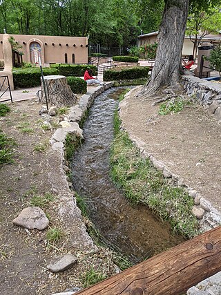
An acequia or séquia is a community-operated watercourse used in Spain and former Spanish colonies in the Americas for irrigation. Particularly in Spain, the Andes, northern Mexico, and the modern-day American Southwest particularly northern New Mexico and southern Colorado, acequias are usually historically engineered canals that carry snow runoff or river water to distant fields. The hydrology of acequias benefit the ecological health, farming production, and maintaining groundwater levels. Examples of acequias in New Mexico have lengthy historical roots to Pueblo and Hispano communities, and they are incorporated into traditions including the matachines, life in the Rio Grande Bosque of the Albuquerque metropolitan area, and pilgrimages to El Santuario de Chimayo.

Old Town is the historic original town site of Albuquerque, New Mexico, for the provincial kingdom of Santa Fe de Nuevo México, established in 1706 by New Mexico governor Francisco Cuervo y Valdés. It is listed on the New Mexico State Register of Cultural Properties as the Old Albuquerque Historic District, and is protected by a special historic zoning designation by the city. The present-day district contains about ten blocks of historic adobe buildings surrounding Old Town Plaza. On the plaza's north side stands San Felipe de Neri Church, a Spanish colonial church constructed in 1793.

Dixon is an unincorporated community located in Rio Arriba County, New Mexico, United States, on New Mexico State Road 75, just east of New Mexico State Road 68, in the north-central part of the state, and is approximately 20 miles (32 km) southwest of Taos. The elevation of Dixon is 6,028 feet (1,837 m) above sea level. It is on the banks of the Embudo Creek, a tributary of the Rio Grande. Embudo Creek flows into the Rio Grande two miles (3.2 km) downstream from Dixon. The town is home to the largest population of organic farmers in the state, as well as several wineries.

The Camino Real de Tierra Adentro, also known as the Silver Route, was a Spanish 2,560-kilometre-long (1,590 mi) road between Mexico City and San Juan Pueblo, New Mexico, that was used from 1598 to 1882. It was the northernmost of the four major "royal roads" that linked Mexico City to its major tributaries during and after the Spanish colonial era.
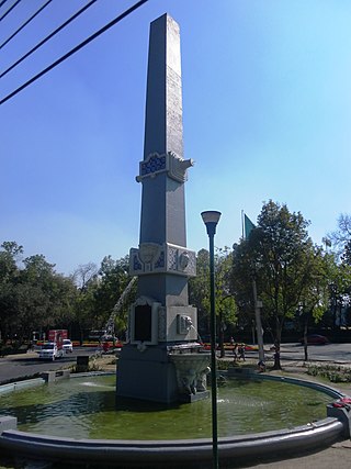
Polanco is a neighborhood in the Miguel Hidalgo borough of Mexico City. Polanco is an affluent colonia, noted for its luxury shopping along Presidente Masaryk Avenue, the most expensive street in Mexico, as well as for the numerous prominent cultural institutions located within the neighborhood.

Tlaxiaco is a city, and its surrounding municipality of the same name, in the Mexican state of Oaxaca. It is located in the Tlaxiaco District in the south of the Mixteca Region, with a population of about 17,450.
Jiquipilco Municipality is one of the municipalities of the State of Mexico in Mexico. It is north of the Toluca Valley, part of the region consisting of the southern and western slopes of Cerro La Catedral, which has a concentration of speakers of the Otomi language. It is about 40 km from Toluca, the state capital. The name is a corruption of Nahuatl “Xiquipilco”, meaning “in the saddlebags”. Jiquipilco is situated on the transversal volcanic axis that crosses Mexico in an area surrounded by lakes and volcanoes. This portion is called "Anahuac”.
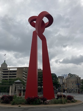
La Antorcha de la Amistad(Spanish for "The Torch of Friendship") is a monumental abstract sculpture by Mexican sculptor Sebastián, installed in Downtown San Antonio, in the U.S. state of Texas. The work was commissioned by a group of Mexican businessmen living in the United States and friends of Mexico, and presented as a gift from the Mexican government to the City of San Antonio in 2002. It was unveiled on June 27, 2002, by the artist, Mayor Edward D. Garza, and then–Secretary of Foreign Affairs for Mexico and political analyst Jorge Castañeda Gutman.

Hacienda San José de Miravalle is a former mezcal-producing hacienda and currently a rural inactive community of the municipality of San Martín de Hidalgo in central Jalisco, Mexico. During the early twentieth-century, the hacienda was known for its productivity of mezcal business until the Mexican agrarian reform and other uprisings caused it dissolution.
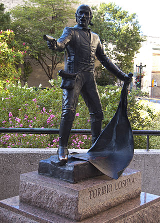
José Toribio Losoya, was a former Mexican soldier, a Texian military participant in the Siege of Bexar and Battle of the Alamo defender.

San Felipe de Austin State Historic Site is a historic site located in San Felipe, Austin County, Texas. The site preserves the location of the first provisional capital and Anglo-American colony in Mexican Texas.
Chihuahuita is a neighborhood in El Paso, Texas. It has also been known as the "First Ward." It is considered the oldest neighborhood in the city. It has also suffered through extreme poverty in its history. It is currently on the Most Endangered Historic Places list as compiled by the National Trust for Historic Preservation. It is located on the border of the Rio Grande at the Mexico–United States border. For most of the twentieth century, the name Chihuahuita was used to refer to all of southern El Paso, often including El Segundo Barrio. In 1991, Chihuahuita was designated as a historic district by the city of El Paso.
Florence Terry Griswold was an American cattlewoman and rancher from Texas. She was the first woman delegate of the Texas Cattle Raisers Association to attend the Trans-Mississippi Convention and for several years, the only woman delegate. A staunch supporter of women's equality, she worked as a suffragist, served as a Republican National Convention Delegate for many years and later fought for equal pay for women. She is most known as the founder of the Pan-American Round Tables in 1916, which has grown from a single club begun in San Antonio, Texas, to an international NGO with over 1400 branches.
María G. "Chata" Sada was a Mexican-American businesswoman, informal educator and midwife in Boquillas Canyon. Sada ran the last store and restaurant in the Boquillas area, "Chata's Place" between 1901 and 1936. Eventually the land it stood on became part of the Big Bend National Park.

Martineztown-Santa Barbara is a neighborhood in central Albuquerque, New Mexico, immediately northeast of Downtown. Originating as a small farming village in the 1850s, it is one of the city's oldest neighborhoods and retains a distinct character, with winding streets, irregular lots, and adobe vernacular buildings reminiscent of other old Hispanic communities in northern New Mexico.
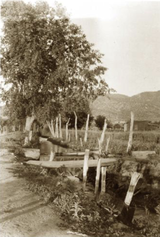
The Acequia Madre is a historical irrigation ditch that flows through the city of Santa Fe, New Mexico. It has been operating for more than 500 years, and is part of the acequia system found throughout New Mexico.
Losoya is an unincorporated community in Bexar County, Texas, United States.
References
- 1 2 Gutierrez, A.E. (Tony) (January 22, 1993). "Sacred Heart Celebrates 98 Years". Del Rio News Herald. Retrieved June 29, 2017– via Newspapers.com.
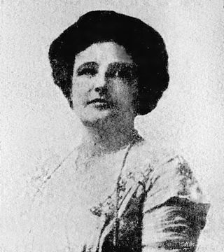
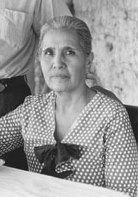
- 1 2 3 4 5 6 7 8 Acosta, Teresa Palomo (June 15, 2010). "Losoya Taylor, Paula". Handbook of Texas Online. Texas State Historical Association. Retrieved June 29, 2017.
- 1 2 "Brown Plaza Kindled SF Pride". Del Rio News Herald. January 24, 1982. Retrieved June 29, 2017– via Newspapers.com.
- ↑ Zumwalt, Glenda (July 4, 1977). "Earl Del Rioans Fought to Survive". Del Rio News Herald. Retrieved June 29, 2017– via Newspapers.com.
- ↑ "Painting for Book Cover". Del Rio News Herald. February 2, 1976. Retrieved June 29, 2017– via Newspapers.com.
- ↑ Gutierrez, A.E. (Tony) (September 30, 1998). "San Felipe Will Survive". Del Rio News Herald. Retrieved June 29, 2017– via Newspapers.com.
- 1 2 Gonzales, Diana (October 25, 1987). "Loma de la Cruz to Get Historical Marker Today". Del Rio News Herald. Retrieved June 29, 2017– via Newspapers.com.
- ↑ "Grande Loma Cemetery". Del Rio News Herald. November 28, 2016. Retrieved 2017-06-29.
- ↑ Thomas, Ann (October 17, 1987). "El Cemeterio Viejo Loma de la Cruz to Get Historical Marker". Del Rio News Herald. Retrieved June 29, 2017– via Newspapers.com.
- ↑ Carmack, George (August 22, 1976). "Del Rio Tale Fascinates". San Antonio Express. Retrieved June 29, 2017– via Newspapers.com.
- ↑ Garza, Cynthia (October 16, 1983). "Comite Cultural Official Sees New Sense of Direction". Del Rio News Herald. Retrieved June 29, 2017– via Newspapers.com.
- ↑ "Historical Markers in Val Verde County". Val Verde County Historical Commission. Retrieved 2017-06-29.