Magnet Cove is a census-designated place (CDP) and former town in Hot Spring County, Arkansas, United States. It is located in the Ouachita Mountains southeast of Hot Springs, on Arkansas Highway 51 north of U.S. Highway 270. As of the 2020 census, the town of Magnet Cove had a population of 692.
Poplar Grove is an unincorporated community and census-designated place (CDP) in Phillips County, Arkansas, United States, located on U.S. Route 49 between Marvell and West Helena. It was first listed as a CDP in the 2020 census with a population of 215.

Canehill, also known as Cane Hill and Boonsboro, is an unincorporated community and census-designated place (CDP) in Washington County, Arkansas, United States. It was first listed as a CDP in the 2020 census with a population of 74.

Cherokee City is an unincorporated census-designated place (CDP) in Benton County, Arkansas, United States. Per the 2020 census, the population was 73. It is the location of Coon Creek Bridge, which is located on Cty Rd. 24 and is listed on the National Register of Historic Places. The community was named for the Cherokee, since the Trail of Tears crossed the landscape when the Cherokee migrated west to Indian territory, now Oklahoma in the late 1830s. The town is within the Northwest Arkansas region, located about 5 miles east of Oklahoma and 4 miles south of the Missouri state line.
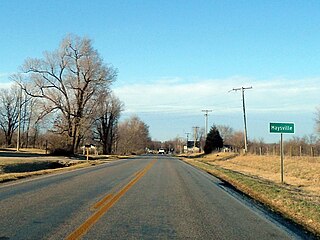
Maysville is an unincorporated community and census-designated place (CDP) in Benton County, Arkansas, United States. It is the westernmost settlement in the state of Arkansas. Per the 2020 census, the population was 117. It is located in the Northwest Arkansas region.

New Edinburg is an unincorporated census-designated place in Cleveland County, Arkansas, United States. Per the 2020 census, the population was 134.

New Blaine is an unincorporated community and census-designated place (CDP) in Logan County, Arkansas, United States. Per the 2020 census, the population was 173.
Oak Grove is an unincorporated community and census-designated place (CDP) in Moreland Township, Pope County, Arkansas, United States. It was first listed as a CDP in the 2020 census with a population of 177.
Princeton is a small unincorporated rural village in Princeton Township, Dallas County, Arkansas, United States, located at the junction of Arkansas highways 8 and 9, 7.5 miles (12.1 km) southwest of Carthage. Princeton Cemetery, which is listed on the National Register of Historic Places, is located in the community. It was first listed as a CDP in the 2020 census with a population of 13.
Springfield is an unincorporated community and census-designated place (CDP) located in the north central part of Arkansas in Conway County. It was first listed as a CDP in the 2020 census with a population of 223.
Cincinnati is an unincorporated community and census-designated place (CDP) in northwestern Washington County, Arkansas, United States. It was first listed as a CDP in the 2020 census with a population of 306.
Drasco is an unincorporated community and census-designated place (CDP) in Cleburne County, Arkansas, United States, with a ZIP code of 72530. Drasco lies just northeast of Greers Ferry Lake and includes the lakeside community of Tannenbaum.
Crystal Springs is an unincorporated community and census-designated place (CDP) in Garland County, Arkansas, United States. It was first listed as a CDP in the 2020 census with a population of 129.
Alleene is an unincorporated community and census-designated place (CDP) in Little River County, Arkansas, United States. It was first listed as a CDP in the 2020 census with a population of 97.

Tumbling Shoals is a census-designated place in Cleburne County, Arkansas, United States. Per the 2020 census, the population was 902.
Centerville is an unincorporated community and census-designated place (CDP) in Yell County, Arkansas, United States. Centerville is located at the junction of Arkansas Highways 7 and 154, 6.5 miles (10.5 km) north-northeast of Ola. It was first listed as a CDP in the 2020 census with a population of 283.
Walcott is an unincorporated community and census-designated place (CDP) in Greene County, Arkansas, United States. Walcott is located at the junction of Arkansas highways 141 and 168, 10 miles (16 km) west of Paragould. It was first listed as a CDP in the 2020 census with a population of 152.
Oneida is an unincorporated community and census-designated place (CDP) in Phillips County, Arkansas, United States. Oneida is located along Arkansas Highway 85, 3.5 miles (5.6 km) north-northeast of Lake View. Oneida has a post office with ZIP code 72369. It was first listed as a CDP in the 2020 census with a population of 13.
Edgemont is an unincorporated community and census-designated place (CDP) in Cleburne County, Arkansas, United States. Edgemont is located on the north side of Greers Ferry Lake along Arkansas Highway 16, 2 miles (3.2 km) northwest of Greers Ferry. Edgemont has a post office with ZIP code 72044.
Aplin is an unincorporated rural village in Perry County, Arkansas, United States. The community is located along Arkansas Highway 60, 10.3 miles (16.6 km) west-southwest of Perryville. In addition to several homes, there is a hearth manufactury located at Aplin, and a church. The Camp House, which is listed on the National Register of Historic Places, is near the community.


