
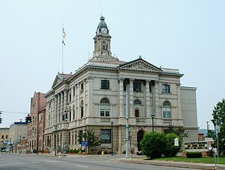
Bradford County is a county in the Commonwealth of Pennsylvania. It is part of Northeastern Pennsylvania. As of the 2020 census, its population was 59,967. Its county seat is Towanda. The county was created on February 21, 1810, from parts of Lycoming and Luzerne Counties. Originally called Ontario County, it was reorganized and separated from Lycoming County on October 13, 1812, and renamed Bradford County for William Bradford, who had been a chief justice of the Pennsylvania Supreme Court and United States Attorney General.

Waverly is the largest village in Tioga County, New York, United States. As of the 2010 U.S. census, Waverly had a population of 4,177. It is located southeast of Elmira in the Southern Tier region. This village was incorporated as the southwest part of the town of Barton in 1854. The village name was conceived by Joseph "Uncle Joe" Hallett, founder of its first Fire Department and pillar of the community, dropping the second "e" from the name of his favorite author's novel, Waverley by Sir Walter Scott. The former village hall is listed on the National Historic Places list.

Athens is a borough in Bradford County, Pennsylvania, United States. It is part of Northeastern Pennsylvania and is located 2 miles (3 km) south of the New York state line on the Susquehanna and Chemung rivers. The population was 3,749 in 1900 and 3,796 in 1910. The population was 3,265 at the 2020 census. Athens is in a small area locally known as "The Valley", a group of four contiguous communities in Pennsylvania and New York: Waverly, New York; South Waverly, Pennsylvania; Sayre, Pennsylvania; and Athens. The Valley has a population near 30,000.

Athens Township is a township in Bradford County, Pennsylvania, United States. It is part of Northeastern Pennsylvania. The population was 5,198 at the 2020 census.

Sayre is a borough in Bradford County, Pennsylvania, United States. It is part of Northeastern Pennsylvania. It is the principal city in the Sayre, PA Micropolitan Statistical Area. It lies 18 miles (29 km) southeast of Elmira, New York, and 30 miles (48 km) southwest of Binghamton. It is currently the largest city in Bradford County. In the past, various iron products were made there. In 1900, 5,243 people lived there; in 1910, 6,426 people lived there, and in 1940, 7,569 persons made their homes in Sayre. The population was 5,403 at the 2020 census.

South Waverly is a borough in Bradford County, Pennsylvania, United States. It is part of Northeastern Pennsylvania. The population was 1,070 at the 2020 census. South Waverly is part of the Penn-York Valley, a group of four contiguous communities in New York and Pennsylvania: Waverly, New York, South Waverly, Sayre, and Athens, with a combined population near 30,000.
Elmira is a city and the county seat of Chemung County, New York, United States. It is the principal city of the Elmira, New York, metropolitan statistical area, which encompasses Chemung County. The population was 26,523 at the 2020 census, down from 29,200 at the 2010 census, a decline of more than 7 percent.

Interstate 86 (I-86) is an Interstate Highway that extends for 223.39 miles (359.51 km) through northwestern Pennsylvania and the Southern Tier region of New York, in the United States. The highway has two segments: the longer of the two begins at an interchange with I-90 east of Erie, Pennsylvania, and ends just beyond the Chemung-Tioga county line at the Pennsylvania border, while the second extends from I-81 east of Binghamton to New York State Route 79 (NY 79) in Windsor. When projects to upgrade the existing NY 17 to Interstate Highway standards are completed, I-86 will extend from I-90 near Erie to the New York State Thruway (I-87) in Woodbury. The portion in Erie County, Pennsylvania, is known as the Hopkins-Bowser Highway and is signed as such at each end. In New York, the current and future alignment of I-86 is known as the Southern Tier Expressway west of I-81 in Binghamton and the Quickway east of I-81.
WENI-FM is an American radio station licensed by the Federal Communications Commission (FCC) to serve the community of South Waverly, Pennsylvania. Starting in early 2010, the then-WPHD moved to Comfort Hill in Ashland, New York, just south of Elmira. WENI-FM is located on the same radio tower as Elmira-licensed WCBF. WENI-FM now has one of the strongest signals in Chemung County, New York, and the greater Elmira area.

WENY-TV is a television station in Elmira, New York, United States, affiliated with ABC, CBS and The CW Plus. Owned by Lilly Broadcasting, the station has studios on Old Ithaca Road in Horseheads, and its transmitter is located on Higman Hill in Corning.

WMAJ is an AM radio station in the Elmira-Corning market of New York state. It broadcasts at 1,000 watts at day and 910 watts at night from studios in Corning, New York. It airs an adult contemporary format branded as "Magic 106.7/106.9".

WCBF is an FM radio station licensed to Elmira, New York. It is owned by Seven Mountains Media and airs a country music format.
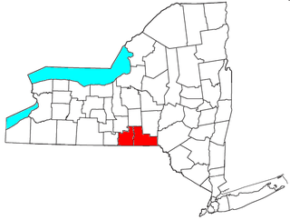
The Binghamton Metropolitan Statistical Area, also called Greater Binghamton or the Triple Cities, is a region of southern Upstate New York in the Northeastern United States, anchored by Binghamton. The MSA encompasses Broome and Tioga counties, which together had a population of 247,138 as of the 2020 census. From 1963 to 1983, the MSA also included neighboring Susquehanna County in Pennsylvania, part of which still falls in the Binghamton, NY–PA Urban Area. In addition to these three counties, the greater region includes parts of Delaware and Chenango counties in New York; portions of Cortland and Otsego counties in New York and Wayne County, Pennsylvania are sometimes considered part of the region as well. Using the definition of a 30-mile radius from Binghamton, the population as of the 2010 census is 317,331.

New York State Route 282 (NY 282) is a north–south state highway located within Tioga County in the Southern Tier of New York in the United States. It extends for 3.48 miles (5.60 km) from the Pennsylvania state line in the town of Nichols, where it connects to Pennsylvania Route 187 (PA 187), to an intersection with NY 17C in the town of Tioga. The route meets the Southern Tier Expressway (NY 17) and crosses over the Susquehanna River just west of the village of Nichols.

Pennsylvania Route 199 is a 4.8-mile-long (7.7 km) state highway located in Bradford County in Pennsylvania. The southern terminus is at U.S. Route 220 near Athens. The northern terminus is the New York state line in Sayre, where it connects to New York State Route 34 and an interchange with Interstate 86 (I-86)/NY 17. PA 199 runs north–south through the Penn-York Valley communities of Athens and Sayre, following Main Street in Athens and Keystone Avenue, Mohawk Street, and Spring Street in Sayre. The section of PA 199 between the southern terminus and the intersection of Keystone Avenue and Mohawk Street in Sayre was designated as part of US 711 when the U.S. Highway System was created in 1926, being renumbered to US 220 a year later. Between 1930 and the 1960s, US 309 was concurrent with this portion of US 220. In the 1970s, US 220 was moved to a western bypass of the towns and PA 199 was designated onto its current alignment.
WCIH is a radio station broadcasting a Christian radio format. Licensed to Elmira, New York, United States, the station serves the Elmira-Corning area. The station is currently owned by Family Life Ministries, Inc.

WAVR and WATS are a pair of radio stations simulcasting an Adult Contemporary format. The stations serve Bradford County, Pennsylvania and Tioga County, New York, located in the Twin Tiers between Elmira and Binghamton. The station is currently owned by Dave Radigan's WATS UP, LLC. The station features a local morning program hosted by Chuck Carver and Todd Bowers called "Chuck and Todd Live" and programming from AP Radio and Jones Radio Network.
The Morning Times is a morning newspaper published Monday through Saturday in Sayre, Pennsylvania. The newspaper serves Athens, Pennsylvania, Sayre, Pennsylvania, Waverly, New York, and the surrounding communities in the Penn-York Valley area of the Twin Tiers. Its coverage area includes portions of Tioga County and Chemung County, New York, and Bradford County, Pennsylvania.
Wysox is an unincorporated community in Bradford County, Pennsylvania, United States. The community is located at the intersection of U.S. Route 6 and Pennsylvania Route 187, 2.3 miles (3.7 km) east of Towanda. Wysox has a post office with ZIP code 18854.
