
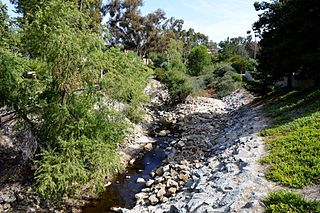
Peters Canyon Wash is a tributary of San Diego Creek in central Orange County in the U.S. state of California. [1]
Peters Canyon Wash is a tributary of San Diego Creek in central Orange County in the U.S. state of California. [1]
About 11.8 miles (19.0 km) long north-south, the wash, now mostly channelized, flows in a relatively straight course southwest from the 55-acre (0.22 km2) Peters Canyon Reservoir near the Orange/Tustin borderline to its confluence with San Diego Creek near the Irvine Civic Center Plaza. [2] Less than 5 miles (8.0 km) below this confluence, San Diego Creek empties into Upper Newport Bay. [3] The largest tributary of Peters Canyon is the Santa Ana Gardens Channel (not to be confused with the Santa Ana-Delhi Channel , which flows directly into Upper Newport Bay.)


The Santa Ana River is the largest river entirely within Southern California in the United States. It rises in the San Bernardino Mountains and flows for most of its length through San Bernardino and Riverside counties, before cutting through the northern Santa Ana Mountains via Santa Ana Canyon and flowing southwest through urban Orange County to drain into the Pacific Ocean. The Santa Ana River is 96 miles (154 km) long, and its drainage basin is 2,650 square miles (6,900 km2) in size.

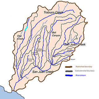
San Juan Creek, also called the San Juan River, is a 29-mile (47 km) long stream in Orange and Riverside Counties, draining a watershed of 133.9 square miles (347 km2). Its mainstem begins in the southern Santa Ana Mountains in the Cleveland National Forest. It winds west and south through San Juan Canyon, and is joined by Arroyo Trabuco as it passes through San Juan Capistrano. It flows into the Pacific Ocean at Doheny State Beach. State Route 74, the Ortega Highway, crosses the Santa Ana Mountains via San Juan Canyon.
Oso Creek is an approximately 13.5-mile (21.7 km) tributary of Arroyo Trabuco in southern Orange County in the U.S. state of California. Draining about 20 square miles (52 km2) in a region north of the San Joaquin Hills and south of the Santa Ana Mountains, the creek is Trabuco Creek's largest tributary, and is part of the San Juan Creek drainage basin. Beginning in the foothills of the Santa Ana Mountains near the city of Mission Viejo, the creek is dammed twice to form Upper Oso Reservoir and Lake Mission Viejo. The creek is channelized and polluted along much of its length.

Arroyo Trabuco is a 22-mile (35 km)-long stream in coastal southern California in the United States. Rising in a rugged canyon in the Santa Ana Mountains of Orange County, the creek flows west and southwest before emptying into San Juan Creek in the city of San Juan Capistrano. Arroyo Trabuco's watershed drains 54 square miles (140 km2) of hilly, semi-arid land and lies mostly in Orange County, with a small portion extending northward into Riverside County. The lower section of the creek flows through three incorporated cities and is moderately polluted by urban and agricultural runoff.

Salt Creek is a small coastal stream in southern Orange County, California in the United States. About 4 miles (6.4 km) long, the creek drains 6.1 square miles (16 km2) in parts of the cities of Laguna Niguel and Dana Point. The creek begins in Laguna Niguel and flows west and south through a narrow canyon, partly in the Salt Corridor Regional Park. It empties into the Pacific Ocean at Salt Creek County Beach in Dana Point.

Santiago Creek is a major watercourse in Orange County in the U.S. state of California. About 34 miles (55 km) long, it drains most of the northern Santa Ana Mountains and is a tributary to the Santa Ana River. It is one of the longest watercourses entirely within the county. The creek shares its name with Santiago Peak, at 5,687 ft (1,733 m) the highest point in Orange County, on whose slopes its headwaters rise.

Laguna Canyon, also called Cañada de las Lagunas, is a gorge that cuts through the San Joaquin Hills in southern Orange County, California, in the United States, directly south of the city of Irvine. The canyon runs from northeast to southwest, and is drained on the north side by tributaries of San Diego Creek and on the south by Laguna Canyon Creek. It is deeper and more rugged on the southwestern end near Laguna Beach.

San Diego Creek is a 16-mile (26 km) urban waterway flowing into Upper Newport Bay in Orange County, California in the United States. Its watershed covers 112.2 square miles (291 km2) in parts of eight cities, including Irvine, Tustin, and Costa Mesa. From its headwaters in Laguna Woods the creek flows northwest to its confluence with Peters Canyon Wash, where it turns abruptly southwest towards the bay. Most of the creek has been converted to a concrete flood control channel, but it also provides important aquatic and riparian habitat along its course and its tidal estuary.

Sulphur Creek is an approximately 4.5-mile (7.2 km) tributary of Aliso Creek in Orange County, California. The creek drains about 6 square miles (16 km2) in the suburban cities of Laguna Niguel and Laguna Hills. Although most of its watershed has been utilized for master planned residential development, the creek retains a natural channel with riparian and wetland habitat in parts of Laguna Niguel Regional Park and Aliso and Wood Canyons Regional Park. Urban runoff has changed the once seasonal creek into a perennial stream.

Coyote Creek is a principal tributary of the San Gabriel River in northwest Orange County and southeast Los Angeles County, California. It drains a land area of roughly 41.3 square miles (107 km2) covering eight major cities, including Brea, Buena Park, Fullerton, Hawaiian Gardens, La Habra, Lakewood, La Palma, and Long Beach. Some major tributaries of the creek in the highly urbanized watershed include Brea Creek, Fullerton Creek, and Carbon Creek. The mostly-flat creek basin is separated by a series of low mountains, and is bounded by several small mountain ranges, including the Chino Hills, Puente Hills, and West Coyote Hills.

Cañada Gobernadora is a tributary to San Juan Creek, about 8.5 miles (13.7 km) long, in southern Orange County in the U.S. state of California. The creek begins in the foothills of the Santa Ana Mountains, at an elevation of 1,040 feet (320 m), and flows south through residential, agricultural and finally undeveloped land, to its confluence with San Juan Creek a few miles upstream of the city of San Juan Capistrano. The upper half of the stream is largely channelized and flows through golf courses, while the lower half is a wash-like channel that can be up to 700 feet (210 m) wide. The stream receives some urban runoff from the residential communities higher in its watershed. The watershed includes several geologic formations, including the Tertiary Sespe Formation and Santiago Formation, and Holocene sedimentary and alluvial deposits embedded in its narrow floodplain. Cañada Gobernadora forms an unofficial dividing line for the lower portion of the San Juan watershed; most urban development is confined to west of the creek's valley, while agricultural and undeveloped lands lie to the east of the creek.

Bell Canyon is a major drainage of the Santa Ana Mountains in Orange County, California in the United States. Bell Creek flows about 14.4 miles (23.2 km) in a southerly direction to its confluence with San Juan Creek. The Bell Canyon drainage is located to the east and parallel to Cañada Gobernadora, and to the south of Trabuco Creek. After Trabuco Creek, it is the second largest tributary of San Juan Creek in terms of length and its watershed area of 26 square miles (67 km2).
Trampas Canyon is a short tributary of San Juan Creek in southern Orange County the U.S. state of California. It rises in forks on steep slopes of the southern Santa Ana Mountains, and flows north to where it is dammed by Trampas Canyon Dam. Trampas Canyon 1795-006 Dam (33.498359°N 117.587548°W) forms a small lake that branches into four forks running east–west. Exiting the dam, the creek flows north and turns slightly to the west, where it joins San Juan Creek on the left bank, near the confluence of Cañada Gobernadora. Trampas Canyon Creek is ephemeral and only flows during storm events or while Trampas Canyon Dam is releasing, and is not a primary tributary of San Juan Creek.
San Juan Creek is a creek in Orange County in the U.S. state of California. It is about 29 miles (47 km) long, and along with its major tributary, Trabuco Creek, drains 133 square miles (340 km2) near the southernmost extent of Orange County. This article describes the course of San Juan Creek.

San Mateo Creek is a stream in Southern California in the United States, whose watershed mostly straddles the border of Orange and San Diego Counties. It is about 22 miles (35 km) long, flowing in a generally southwesterly direction. Draining a broad valley bounded by the Santa Ana Mountains and Santa Margarita Mountains, San Mateo Creek is notable for being one of the last unchannelized streams in Southern California.
Sand Canyon Wash is an approximately 6.9-mile (11.1 km) tributary of San Diego Creek in Orange County, southern California.
Serrano Creek is a roughly 7.5-mile (12.1 km) tributary of San Diego Creek in the U.S. state of California. The creek starts in the Santa Ana Mountains in a canyon in Whiting Ranch Wilderness Park, near the boundary of the Cleveland National Forest. It then flows southwest into the city of Lake Forest, running in a channelized course roughly parallel to Aliso Creek. It abruptly turns northwest then southwest at 90-degree angles as it enters a large storm drain that takes it the rest of the way to the confluence with the La Cañada Channel, creating the main stem of San Diego Creek.

Temescal Creek is an approximately 29-mile-long (47 km) watercourse in Riverside County, in the U.S. state of California. Flowing primarily in a northwestern direction, it connects Lake Elsinore with the Santa Ana River. It drains the eastern slopes of the Santa Ana Mountains on its left and on its right the western slopes of the Temescal Mountains along its length. With a drainage basin of about 1,000 square miles (2,600 km2), it is the largest tributary of the Santa Ana River, hydrologically connecting the 720-square-mile (1,900 km2) San Jacinto River and Lake Elsinore watersheds to the rest of the Santa Ana watershed. However, flowing through an arid rain shadow zone of the Santa Ana Mountains, and with diversion of ground water for human use, the creek today is ephemeral for most of its length, except for runoff from housing developments and agricultural return flows.

Peters Canyon Regional Park is a regional park within the Orange County Regional Parks System in California. The park contains 354 acres of southern California wildlife, including coastal sage shrub, riparian, freshwater marsh, and grasslands, and is located within the boundaries of both Orange, California and Tustin, California. Peters Canyon was given to this city in 1992 by the Irvine Company who had used it previously for cattle grazing. The canyon is lined with a residential area on one side and open hills on the other. This canyon is commonly used by hikers, mountain bikers, and equestrians because of the trails that circumvent the 50 acre man-made lake, which was constructed by the Irvine Company in 1931, on the interior of the plot. The regional park is open from 7:00 AM to sunset every day of the week, save for the chance of rain or hazardous conditions, in which case the park will be closed for three days following the particular occurrence.
![]() Media related to Peters Canyon Wash at Wikimedia Commons
Media related to Peters Canyon Wash at Wikimedia Commons
33°41′38″N117°49′09″W / 33.69399614732679°N 117.81922743176183°W