Petersburg, Michigan

Last updated
Petersburg, Michigan
Petersburg east center street (2020).JPG
Looking west along East Center Street
Petersburg, MI location 2020.png
Location within Monroe County
USA Michigan location map.svg
Red pog.svg
Petersburg
Usa edcp location map.svg
Red pog.svg
Petersburg
Coordinates: 41°54′04″N83°42′54″W / 41.90111°N 83.71500°W / 41.90111; -83.71500
CountryUnited States
State Michigan
County Monroe
Settled1824
Established1836
Incorporated1869 (village)
1967 (city)
Government
  Type Mayor–council
   Mayor James Holeman
   Clerk Leanne Goodin
Area
[1]
  Total0.49 sq mi (1.27 km2)
  Land0.48 sq mi (1.24 km2)
  Water0.01 sq mi (0.03 km2)
Elevation
676 ft (206 m)
Population
 (2020) [2]
  Total1,171
  Density2,425.5/sq mi (936.48/km2)
Time zone UTC-5 (Eastern (EST))
  Summer (DST) UTC-4 (EDT)
ZIP Code
49270
Area code 734
FIPS code 26-63800 [3]
GNIS feature ID0634708 [4]
Website www.petersburg-mi.com

Petersburg is a city in Monroe County in the U.S. state of Michigan. The population was 1,171 at the 2020 census. [2]

Contents

At 0.49 square miles (1.27 km2), Petersburg is the second-smallest city by land area in the state of Michigan, after Clarkston.

History

The area was originally settled by Richard Peters as early as 1824, and he became the first postmaster when the Summerfield post office was established in April 1831. Monroe natives Thomas Cole and Austin Wing formally established the community on land purchased from Peters in 1836. The post office was renamed "Petersburgh" on January 14, 1863. The community incorporated as a village in 1869. The post office name was shortened to Petersburg on December 18, 1893. The village incorporated as a city in 1967. [5]

Geography

Petersburg is in western Monroe County, 17 miles (27 km) west of Monroe, the county seat, the same distance east of Adrian, and 21 miles (34 km) north of Toledo, Ohio. According to the U.S. Census Bureau, Petersburg has a total area of 0.49 square miles (1.27 km2), of which 0.01 square miles (0.03 km2), or 1.83%, are water. [1] The River Raisin, a tributary of Lake Erie, forms part of the northwest edge of the city.

Demographics

Historical population
CensusPop.Note
1880 420
1890 408−2.9%
1900 46814.7%
1910 4904.7%
1920 5144.9%
1930 70537.2%
1940 78911.9%
1950 1,00126.9%
1960 1,0181.7%
1970 1,22720.5%
1980 1,222−0.4%
1990 1,201−1.7%
2000 1,157−3.7%
2010 1,146−1.0%
2020 1,1712.2%
U.S. Decennial Census [6]

2010 census

As of the census [7] of 2010, there were 1,146 people, 449 households, and 315 families living in the city. The population density was 2,387.5 inhabitants per square mile (921.8/km2). There were 476 housing units at an average density of 991.7 per square mile (382.9/km2). The racial makeup of the city was 97.1% White, 0.3% African American, 0.3% Native American, 0.3% Asian, 0.3% from other races, and 1.6% from two or more races. Hispanic or Latino of any race were 1.7% of the population.

There were 449 households, of which 35.4% had children under the age of 18 living with them, 50.6% were married couples living together, 14.7% had a female householder with no husband present, 4.9% had a male householder with no wife present, and 29.8% were non-families. 22.5% of all households were made up of individuals, and 9.2% had someone living alone who was 65 years of age or older. The average household size was 2.55 and the average family size was 3.00.

The median age in the city was 36.6 years. 25% of residents were under the age of 18; 8.8% were between the ages of 18 and 24; 27% were from 25 to 44; 26.3% were from 45 to 64; and 12.8% were 65 years of age or older. The gender makeup of the city was 49.7% male and 50.3% female.

2000 census

As of the census [3] of 2000, there were 1,157 people, 423 households, and 307 families living in the city. The population density was 2,497.8 inhabitants per square mile (964.4/km2). There were 442 housing units at an average density of 954.2 per square mile (368.4/km2). The racial makeup of the city was 96.80% White, 0.35% African American, 0.43% Native American, 0.09% Asian, 0.35% from other races, and 1.99% from two or more races. Hispanic or Latino of any race were 1.12% of the population.

There were 423 households, out of which 39.0% had children under the age of 18 living with them, 58.4% were married couples living together, 9.7% had a female householder with no husband present, and 27.2% were non-families. 23.6% of all households were made up of individuals, and 9.9% had someone living alone who was 65 years of age or older. The average household size was 2.74 and the average family size was 3.23.

In the city, the population was spread out, with 30.5% under the age of 18, 9.2% from 18 to 24, 32.1% from 25 to 44, 19.5% from 45 to 64, and 8.7% who were 65 years of age or older. The median age was 32 years. For every 100 females, there were 94.5 males. For every 100 females age 18 and over, there were 91.9 males.

The median income for a household in the city was $44,861, and the median income for a family was $58,000. Males had a median income of $44,712 versus $26,250 for females. The per capita income for the city was $21,657. About 7.3% of families and 9.3% of the population were below the poverty line, including 14.8% of those under age 18 and 6.1% of those age 65 or over.

Education

Petersburg is served by Summerfield Schools. [8]

Notable people

Images

Related Research Articles

<span class="mw-page-title-main">Hecker, Illinois</span> Village in Illinois, United States

Hecker is a village in Monroe County in the U.S state of Illinois. The population was 429 at the 2020 census, down from 481 in 2010.

<span class="mw-page-title-main">Summerfield, Illinois</span> Village in Illinois, United States

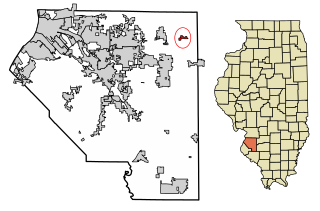
Summerfield is a village in St. Clair County, Illinois, United States. The population was 451 at the 2010 census.

<span class="mw-page-title-main">Summerfield, Kansas</span> City in Marshall County, Kansas

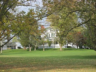
Summerfield is a city in Marshall County, Kansas, United States. As of the 2020 census, the population of the city was 125. The Kansas-Nebraska state border is the north edge of the city.

<span class="mw-page-title-main">Summerfield Township, Clare County, Michigan</span> Civil township in Michigan, United States

Summerfield Township is a civil township of Clare County in the U.S. state of Michigan. The population was 459 at the 2020 census.

<span class="mw-page-title-main">Detroit Beach, Michigan</span> Census-designated place & unincorporated community in Michigan, United States

Detroit Beach is an unincorporated community and census-designated place (CDP) in Monroe County in the U.S. state of Michigan. The population was 1,957 at the 2020 census. The CDP is located within Frenchtown Charter Township, and as an unincorporated community, Detroit Beach has no legal autonomy of its own.

<span class="mw-page-title-main">Luna Pier, Michigan</span> City in Michigan, United States

Luna Pier is a city in Monroe County in the U.S. state of Michigan. The population was 1,382 at the 2020 census.Previously known as "Lakewood", it was established in the early 1900s and incorporated as a city in 1963.

<span class="mw-page-title-main">South Monroe, Michigan</span> Census-designated place & unincorporated community in Michigan, United States

South Monroe is an unincorporated community and census-designated place (CDP) in Monroe County in the U.S. state of Michigan. The population was 6,468 at the 2020 census. The CDP is located within Monroe Charter Township.

<span class="mw-page-title-main">South Rockwood, Michigan</span> Village in Michigan, United States

South Rockwood is a village in Monroe County in the U.S. state of Michigan. The population was 1,587 at the 2020 census. The village is located within Berlin Charter Township.

<span class="mw-page-title-main">Stony Point, Michigan</span> Census-designated place & unincorporated community in Michigan, United States

Stony Point is an unincorporated community and census-designated place (CDP) in Monroe County in the U.S. state of Michigan. The population was 1,784 at the 2020 census. The CDP is located within Frenchtown Charter Township.

<span class="mw-page-title-main">West Monroe, Michigan</span> Census-designated place & unincorporated community in Michigan, United States

West Monroe is an unincorporated community and census-designated place (CDP) in Monroe County in the U.S. state of Michigan. The population was 3,227 at the 2020 census. The CDP is located within Monroe Charter Township.

Monroe Township is a civil township of Newaygo County in the U.S. state of Michigan. As of the 2000 census, the township population was 324.

<span class="mw-page-title-main">Keego Harbor, Michigan</span> City in Michigan, United States

Keego Harbor is a city in Oakland County in the U.S. state of Michigan. A northern suburb of Detroit, Keego Harbor is located roughly 27 miles (43.5 km) from downtown Detroit, and about 3 miles (4.8 km) southwest of Pontiac. As of the 2010 census, the city had a population of 2,970. With a land area of 0.50 square miles (1.29 km2), Keego Harbor is the third-smallest city by land area in the state of Michigan, after Petersburg and Clarkston.

<span class="mw-page-title-main">Sylvan Lake, Michigan</span> City in Michigan, United States

Sylvan Lake is a city in Oakland County in the U.S. state of Michigan. A northern suburb of Detroit, Sylvan Lake is located roughly 26 miles (41.8 km) from downtown Detroit, and borders Pontiac to the east. As of the 2010 census, the city had a population of 1,720. With a land area of 0.51 square miles (1.32 km2), Sylvan Lake is the fourth-smallest city by land area in the state after Clarkston, Petersburg, and neighboring Keego Harbor.

<span class="mw-page-title-main">Flat Rock, Michigan</span> City in Michigan, United States

Flat Rock is a city in Wayne County, Michigan, United States, with a small portion of the city extending into Monroe County. At the 2020 census, the population was 10,541.

<span class="mw-page-title-main">Old Monroe, Missouri</span> City in Missouri, United States

Old Monroe is a city in Lincoln County, Missouri, United States. The population was 265 at the 2010 census.

<span class="mw-page-title-main">Stafford, Ohio</span> Village in Ohio, United States

Stafford is a village in Monroe County, Ohio, United States. The population was 71 at the 2020 census.

<span class="mw-page-title-main">Summerfield, Ohio</span> Village in Ohio, United States

Summerfield is a village in Noble County, Ohio, United States. The population was 237 at the 2020 census.

<span class="mw-page-title-main">Monroe City, Missouri</span> City in Missouri, United States

Monroe City is a city in Marion, Monroe, and Ralls counties in the U.S. state of Missouri. The population was 2,652 at the 2020 census.

<span class="mw-page-title-main">Monroe, Ohio</span> City in Ohio, United States

Monroe is a city in east central Butler and west central Warren counties in the southwestern part of the U.S. state of Ohio. The population was 15,412 at the 2020 census. Monroe is a part of the Cincinnati metropolitan area.

<span class="mw-page-title-main">Summerfield Township, Monroe County, Michigan</span> Civil township in Michigan, United States

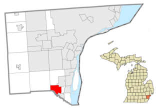
Summerfield Township is a civil township of Monroe County in the U.S. state of Michigan. The population was 3,308 at the 2010 census.

References

  1. 1 2 "2023 U.S. Gazetteer Files: Michigan". United States Census Bureau. Retrieved October 30, 2023.
  2. 1 2 "P1. Race – Petersburg city, Michigan: 2020 DEC Redistricting Data (PL 94-171)". U.S. Census Bureau. Retrieved October 31, 2023.
  3. 1 2 "U.S. Census website". United States Census Bureau . Retrieved 2008-01-31.
  4. "US Board on Geographic Names". United States Geological Survey. 2007-10-25. Retrieved 2008-01-31.
  5. Romig, Walter (October 1, 1986) [1973]. Michigan Place Names: The History of the Founding and the Naming of More Than Five Thousand Past and Present Michigan Communities. p. 438, 544. ISBN   978-0-8143-1838-6.{{cite book}}: |work= ignored (help)
  6. "Census of Population and Housing". Census.gov. Retrieved June 4, 2015.
  7. "U.S. Census website". United States Census Bureau . Retrieved 2012-11-25.
  8. Michigan Geographic Framework (15 November 2013). "Monroe County School Districts" (PDF). Archived (PDF) from the original on 2014-08-21. Retrieved August 28, 2022.