
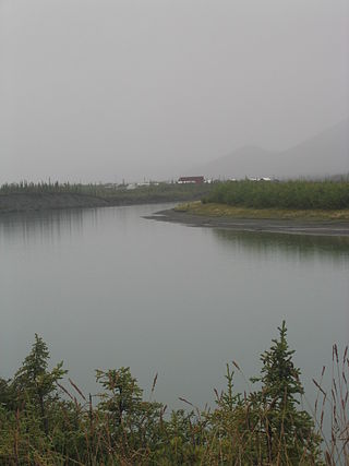
The Yukon River is a major watercourse of northwestern North America. From its source in British Columbia, Canada, it flows through Canada's territory of Yukon. The lower half of the river continues westward through the U.S. state of Alaska. The river is 3,190 kilometres (1,980 mi) long and empties into the Bering Sea at the Yukon–Kuskokwim Delta. The average flow is 6,400–7,000 m3/s (230,000–250,000 cu ft/s). The total drainage area is 833,000 km2 (321,500 sq mi), of which 323,800 km2 (125,000 sq mi) lies in Canada. The total area is more than 25% larger than Texas or Alberta.
The Chandalar River is a 100-mile (160 km) tributary of the Yukon River in the U.S. state of Alaska. Its peak flow, recorded by the United States Geological Survey (USGS) between 1964 and 1974 at a stream gauge at Venetie, was 62,800 cubic feet per second (1,780 m3/s) on June 9, 1968.
The Wind River is a tributary of the East Fork Chandalar River in the U.S. state of Alaska. It arises in the Philip Smith Mountains of the Brooks Range and flows into the East Fork and eventually into the Yukon River.
Mount Bond is a mountain located in Grafton County, New Hampshire, United States. The mountain is named after Professor George P. Bond (1825–1865) of Harvard University, and is the southernmost extension of the Twin Range of the White Mountains. Mount Bond is flanked to the north by Mount Guyot.

The Cabinet Mountains are part of the Rocky Mountains, located in northwest Montana and the Idaho panhandle, in the United States. The mountains cover an area of 2,134 square miles (5,530 km2). The Cabinet Mountains lie south of the Purcell Mountains, between the Kootenai River and Clark Fork River and Idaho's Lake Pend Oreille. The Cabinet Mountains lie to the east of the Purcell Trench. The Cabinet Mountains form the north side of the Clark Fork River valley in Idaho and Montana. The Cabinet Mountains Wilderness is located east of the Bull River near Noxon, Montana in roughly the center of the range.

Dial Mountain is a mountain located in Essex County, New York. The mountain is part of the Colvin Range. Dial Mountain is flanked to the southwest by Nippletop.

Hough Peak is a mountain located in Essex County, New York. The mountain, part of the Dix Range, is named after Franklin B. Hough (1822–1885), the first chief of the United States Division of Forestry, and sometimes called the "father of American forestry". Hough Peak is flanked to the north by Dix Mountain, and to the south by South Dix.
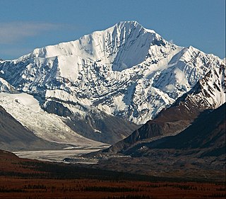
Mount Isto is the highest peak in the Brooks Range, Alaska, USA. Located in the eastern Brooks Range, in what are known as the Romanzof Mountains, Mount Isto is 5 miles (8.0 km) south of Mount Hubley, the second tallest peak in the Brooks Range. Mount Isto is within the Arctic National Wildlife Refuge and was named in 1966 for Reynold E. (Pete) Isto, a civil engineer for the U.S. Geological Survey. In 2014, new measurement technology established that Mount Isto is the highest peak in the Brooks Range. Previously, Mount Chamberlin was believed to be the tallest, but it is now ranked third.

The Swan Range is a mountain range in western Montana in the United States. Its peaks typically rise to around 8,000 to 9,000 feet. The range is bounded by the South Fork Flathead River to the east, the Flathead River to the north and northwest, the Swan River to the west, and lie to the southwest of Glacier National Park, just south of the Canada–US border. It runs about 99 miles (159 km) from north-northwest to south-southeast. Major cities near the Swan Range include Kalispell and Bigfork to the northwest, and Seeley Lake on the south.

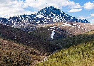
The Endicott Mountains are a range of mountains, part of the Brooks Range in northern Alaska. They are located in the middle of the Brooks range and run some 151 miles (243 km) east–west. To the east are the Philip Smith Mountains and to the west are the Schwatka Mountains. The Endicott Mountains are separated from the Philip Smith Mountains by the Middle Fork of the Koyukuk River, the Dalton Highway, and Atigun Pass. The Endicott Mountains are separated from the Schwatka Mountains by Walker Lake, the upper reaches of the West Fork of the Kobuk River, Akabluak Pass, and the Noatak River. The Endicott Mountains are separated from the mountains north of the Schwatka by Lucky Six Creek, Gull Pass, Gull Creek, a portion of the Alatna River and the Killik River.

Ptarmigan Peak is the highest summit of the South Williams Fork Mountains range in the Rocky Mountains of North America. The peak is north of Dillon, CO in the White River National Forest.
Sukakpak Mountain is a prominent 4,459-foot mountain summit located in the Philip Smith Mountains of the Brooks Range, in the U.S. state of Alaska. The peak is situated 90 miles north of the Arctic Circle near milepost 203 on the Dalton Highway, and 200 mi (322 km) north-northwest of Fairbanks, where the Bettles and Dietrich Rivers merge to form Middle Fork Koyukuk River. The peak's Sukakpak name was reported in 1930 by the USGS as an Inupiat word, said to mean "marten deadfall." From the north, the mountain resembles a carefully balanced log used to trap marten. The name was officially adopted in 1932 by the U.S. Board on Geographic Names.

Dillon Mountain is a prominent 4,820-foot mountain summit located in the Philip Smith Mountains of the Brooks Range, in the U.S. state of Alaska. The peak is situated 93 miles north of the Arctic Circle near milepost 207 on the Dalton Highway, and 200 mi (322 km) north-northwest of Fairbanks, where the Bettles and Dietrich Rivers merge to form Middle Fork Koyukuk River. Sukakpak Mountain rises 3 mi (5 km) to the southwest, and Dietrich Camp of the Trans-Alaska Pipeline lies 3 mi (5 km) to the northwest. The peak was named after John Thomas Dillon (1947-1987), a geologist with the Alaska Division of Geological and Geophysical Surveys who mapped the geology of the southern Brooks Range mineral belt. He died tragically with his father, Stephen Patrick Dillon, in an airplane crash in the Brooks Range while returning home from field work in July 1987. The name was officially adopted in 1990 by the U.S. Board on Geographic Names. This landmark is notable for its massive west face composed of Skajit limestone rising nearly 3,400 feet above the surrounding valley.
Poss Mountain is a prominent 6,180-foot mountain summit located in the Philip Smith Mountains of the Brooks Range, in the U.S. state of Alaska. The peak is situated 80 miles north of the Arctic Circle, five miles east of Dalton Highway, 11.3 mi (18 km) south of Sukakpak Mountain, and 190 mi (306 km) north-northwest of Fairbanks. The peak was named about 1930 by wilderness activist Robert Marshall after "Poss" Postlethwaite, an early and old gold prospector in this area around Wiseman. Robert Marshall described the then 78-year-old Postlethwaite as "the oldest man in the Koyukuk," having spent 32 winters in the area. The name was officially adopted in 1932 by the U.S. Board on Geographic Names. The Poss Mountain Research Natural Area was designated in 1991 to protect natural mineral licks and lambing habitat for Dall sheep. Precipitation runoff from the mountain drains into tributaries of the Middle and South Forks of Koyukuk River.
Hess Mountain, also known as Mount Hess, is an 11,940 ft (3,640 m) elevation glaciated summit located on the crest of the Alaska Range, in Alaska, United States. It is the seventh-highest peak in the Hayes Range which is a subrange of the Alaska Range. This remote peak is situated 13.3 mi (21 km) west of Mount Hayes, and 90 mi (145 km) south of Fairbanks. Mount Deborah, the nearest higher neighbor, is positioned 2.8 mi (5 km) to the west. Precipitation runoff from the mountain drains into tributaries of the Susitna and Tanana River drainage basins. The mountain's name was reported in 1912 by the United States Geological Survey. The first ascent was made May 24, 1951, by Alston Paige, Dick Holdren, Ed Huizer, Howard Bowman, and Elton Thayer. The first ascent via the North Ridge was made May 23, 1976, by Steven Hackett and Thomas Hillis.
