Phytochorion

Last updated

A phytochorion, in phytogeography, is a geographic area with a relatively uniform composition of plant species. Adjacent phytochoria do not usually have a sharp boundary, but rather a soft one, a transitional area in which many species from both regions overlap. The region of overlap is called a vegetation tension zone .

Contents

In traditional schemes, areas in phytogeography are classified hierarchically, according to the presence of endemic families, genera or species, e.g., in floral (or floristic, phytogeographic) zones and regions, [1] or also in kingdoms, regions and provinces, [2] sometimes including the categories empire and domain. However, some authors prefer not to rank areas, referring to them simply as "areas", "regions" (in a non hierarchical sense) or "phytochoria". [3]

Systems used to classify vegetation can be divided in two major groups: those that use physiognomic-environmental parameters and characteristics and those that are based on floristic (i.e. shared genera and species) relationships. [4] Phytochoria are defined by their plant taxonomic composition, while other schemes of regionalization (e.g., vegetation type, physiognomy, plant formations, biomes) may variably take in account, depending on the author, the apparent characteristics of a community (the dominant life-form), environment characteristics, the fauna associated, anthropic factors or political-conservationist issues. [5]

Explanation

Several systems of classifying geographic areas where plants grow have been devised. Most systems are organized hierarchically, with the largest units subdivided into smaller geographic areas, which are made up of smaller floristic communities, and so on. Phytochoria are defined as areas possessing a large number of endemic taxa. Floristic kingdoms are characterized by a high degree of family endemism, floristic regions by a high degree of generic endemism, and floristic provinces by a high degree of species endemism. Systems of phytochoria have both significant similarities and differences with zoogeographic provinces, which follow the composition of mammal families, and with biogeographical provinces or terrestrial ecoregions, which take into account both plant and animal species.

The term "phytochorion" (Werger & van Gils, 1976) [6] is especially associated with the classifications according to the methodology of Josias Braun-Blanquet, which is tied to the presence or absence of particular species, [7] mainly in Africa. [8]

Taxonomic databases tend to be organized in ways which approximate floristic provinces, but which are more closely aligned to political boundaries, for example according to the World Geographical Scheme for Recording Plant Distributions.

Early schemes

In the late 19th century, Adolf Engler (1844-1930) was the first to make a world map with the limits of distribution of floras, with four major floral regions (realms). [9] [10] His Syllabus der Pflanzenfamilien , from the third edition (1903) onwards, also included a sketch of the division of the earth into floral regions. [11]

Other important early works on floristics includes Augustin de Candolle (1820), [12] Schouw (1823), [13] Alphonse de Candolle (1855), [14] Drude (1890), [1] Diels (1908), [15] and Rikli (1913). [16]

Good (1947) regionalization

Good (1947) floristic kingdoms Florenreiche.jpg
Good (1947) floristic kingdoms

Botanist Ronald Good (1947) identified six floristic kingdoms (Boreal or Holarctic, Neotropical, Paleotropical, South African, Australian, and Antarctic), the largest natural units he determined for flowering plants. Good's six kingdoms are subdivided into smaller units, called regions and provinces. The Paleotropical kingdom is divided into three subkingdoms, which are each subdivided into floristic regions. Each of the other five kingdoms are subdivided directly into regions. There are a total of 37 floristic regions. Almost all regions are further subdivided into floristic provinces. [17]

Takhtajan (1978, 1986) regionalization

Armen Takhtajan (1978, 1986), in a widely used scheme that builds on Good's work, identified thirty-five floristic regions, each of which is subdivided into floristic provinces, of which there are 152 in all. [18] [19] [20] [21]

Holarctic Kingdom

I. Circumboreal region

1 Arctic province
2 Atlantic Europe province
3 Central Europe province
4 Illyria or Balkan province
5 Pontus Euxinus province
6 Caucasus province
7 Eastern Europe province
8 Northern Europe province
9 Western Siberia province
10 Altai-Sayan province
11 Central Siberia province
12 Transbaikalia province
13 Northeastern Siberia province
14 Okhotsk-Kamchatka province
15 Canada incl. Great Lakes province

II. Eastern Asiatic region

16 Manchuria province
17 Sakhalin-Hokkaidō province
18 Japan-Korea province
19 Volcano-Bonin province
20 Ryūkyū or Tokara-Okinawa province
21 Taiwan province
22 Northern China province
23 Central China province
24 Southeastern China province
25 Sikang-Yuennan province
26 Northern Burma province
27 Eastern Himalaya province
28 Khasi-Manipur province

III. North American Atlantic region

29 Appalachian province (forested areas extending east to include the piedmont and west to the start of the prairies)
30 Atlantic and Gulf Coastal Plain province
31 North American Prairies province

IV. Rocky Mountain region

32 Vancouverian province
33 Rocky Mountains province

V. Macaronesian region

34 Azores province
35 Madeira province
36 Canaries province
37 Cape Verde province

VI. Mediterranean region

38 Southern Morocco province
39 Southwestern Mediterranean province
40 South Mediterranean province
41 Iberia province
42 Baleares province
43 Liguria-Tyrrhenia province
44 Adriatic province
45 East Mediterranean province
46 Crimea-Novorossijsk province

VII. Saharo-Arabian region

47 Sahara province
48 Egypt-Arabia province

VIII. Irano-Turanian region

8A. Western Asiatic subregion
49 Mesopotamia province
50 Central Anatolia province
51 Armenia-Iran province
52 Hyrcania province
53 Turania or Aralo-Caspia province
54 Turkestan province
55 Northern Baluchistan province
56 Western Himalaya province
8B. Central Asiatic subregion
57 Central Tien Shan province
58 Dzungaria-Tien Shan province
59 Mongolia province
60 Tibet province

IX. Madrean Region

61 Great Basin province
62 Californian province
63 Sonoran province
64 Mexican Highlands province

Paleotropical Kingdom

X. Guineo-Congolian region

65 Upper Guinean forests province
66 Nigeria-Cameroon province
67 Congo province

XI. Usambara-Zululand region

68 Zanzibar-Inhambane province
69 Tongoland-Pondoland province

XII. Sudano-Zambezian region

12A. Zambezian subregion
70 Zambezi province
12B. Sahelo–Sudanian subregion
71 Sahel province
72 Sudan province
12C. Eritreo–Arabian subregion
73 Somalia-Ethiopia province
74 South Arabia province
75 Socotra province
12C. Omano-Sindian subregion
76 Oman province
77 South Iran province
78 Sindia province

XIII. Karoo-Namib region

79 Namibia province
80 Namaland province
81 Western Cape province
82 Karoo province

XIV. St. Helena and Ascension region

83 St. Helena and Ascension province

XV. Madagascan region

84 Eastern Madagascar province
85 Western Madagascar province
86 Southern and Southwestern Madagascar province
87 Comoro province
88 Mascarenes province
89 Seychelles province

XVI. Indian region

90 Ceylon (Sri Lanka) province
91 Malabar province
92 Deccan province
93 Upper Gangetic Plain province
94 Bengal province

XVII. Indochinese region

95 South Burma province
96 Andamans province
97 South China province
98 Thailand province
99 North Indochina province
100 Annam province
101 South Indochina province

XVIII. Malesian region

18A. Malesian subregion
102 Malaya province
103 Borneo province
104 Philippines province
105 Sumatra province
106 Java province
18B. Papuan subregion
107 Celebes province
108 Moluccas and West New Guinea province
109 Papua province
110 Bismarck Archipelago province

XIX. Fijian region

111 New Hebrides province
112 Fiji province

XX. Polynesian region

113 Micronesia province
114 Polynesia province

XXI. Hawaiian region

115 Hawaii province

XXII. Neocaledonian region

116 New Caledonia province

Neotropical Kingdom

XXIII. Caribbean region

117 Central America province
118 West Indies province
119 Galápagos Islands province

XXIV. region of the Guayana Highlands

120 The Guianas province

XXV. Amazon region

121 Amazonia province
122 Llanos province

XXVI. Brazilian region

123 Caatinga province
124 Central Brazilian Uplands province
125 Chaco province
126 Atlantic province
127 Paraná province

XXVII. Andean region

128 Northern Andes province
129 Central Andes province

South African Kingdom

XXVIII. Cape region

130 Cape province

Australian Kingdom

XXIX. Northeast Australian region

131 North Australia province
132 Queensland province
133 Southeast Australia province
134 Tasmania province

XXX. Southwest Australian region

135 Southwest Australia province

XXXI. Central Australian or Eremaean region

136 Eremaea province

Antarctic Kingdom

XXXII. Fernandezian region

137 Juan Fernández province

XXXIII. Chile-Patagonian region

138 Northern Chile province
139 Central Chile province
140 Pampas province
141 Patagonia province
142 Tierra del Fuego province

XXXIV. region of the South Subantarctic Islands

143 Tristan-Gough province
144 Kerguelen province

XXXV. Neozeylandic region

145 Lord Howe province
146 Norfolk province
147 Kermadec province
148 Northern New Zealand province
149 Central New Zealand province
150 Southern New Zealand province
151 Chatham province
152 New Zealand Subantarctic Islands province

Regionalization according to Wolfgang Frey and Rainer Lösch (2004, 2010)

Flora regions in Europe Floristic regions in Europe (english).png
Flora regions in Europe
Notes
(with focus on Europe, matching the image on the right) [22] [23]

Liu et al. (2023, 2024) Regionalization

Critiquing previous attempts for their lack of phylogenetic relationships in the construction of their regions, Liu et al. incorporated distribution data alongside phylogenetic relationships to configure their realms. This led to the classification of eight realms organized into two super-realms and each composed of a number of sub-realms. [24]

1 African
2 Indo-Malesian
3 Australian
4 Novozealandic
5 Neotropical
6 Chile-Patagonian
7 Holarctic
8 Saharo-Arabian

Differences from Takhtajan's floristic kingdoms mainly focus on emphasizing the uniqueness of certain realms that he had as subdivisions within kingdoms. Two examples are separating some kingdoms into two separate realms, as happened to the Paleotropical and Antarctic kingdoms, reasoning that they have been separated form each other for long enough time to constitute a different phylogenetic trajectory. The merging of the Cape floristic kingdom with the African realm was based by the low endemism of higher taxonomic ranks, which could be found outside the cape region in the rest of Africa. The final major change is the separation of the Saharo-Arabian realm from the Holarctic kingdom, though they admit the northern boundary is not clear, with flora from the Holarctic being found within this area.

After publishing their regions, Dr. Hong Qian criticized Liu et al. for the inclusion of nonnative distributions in their analyses. [25] In response to this, the group cleaned their data to remove nonnative ranges and reassessed their regions. They suggest that the previous inclusion of exotic species did not significantly affect their mapping and found that the cleaned data revealed the same floristic realms. [26]

Related Research Articles

<span class="mw-page-title-main">Nearctic realm</span> Biogeographic realm encompassing temperate North America

The Nearctic realm is one of the eight biogeographic realms constituting the Earth's land surface.

<span class="mw-page-title-main">Biogeographic realm</span> Broadest biogeographic division of Earths land surface

A biogeographic realm is the broadest biogeographic division of Earth's land surface, based on distributional patterns of terrestrial organisms. They are subdivided into bioregions, which are further subdivided into ecoregions. A biogeographic realm is also known as "ecozone", although that term may also refer to ecoregions.

<span class="mw-page-title-main">Ecoregions of Madagascar</span>

The ecoregions of Madagascar, as defined by the World Wildlife Fund, include seven terrestrial, five freshwater, and two marine ecoregions. Madagascar's diverse natural habitats harbour a rich fauna and flora with high levels of endemism, but most ecoregions suffer from habitat loss.

<span class="mw-page-title-main">Boreal Kingdom</span> Floristic kingdom in northern Eurasia and the Americas

The Boreal Kingdom or Holarctic Kingdom (Holarctis) is a floristic kingdom identified by botanist Ronald Good, which includes the temperate to Arctic portions of North America and Eurasia. Its flora is inherited from the ancient supercontinent of Laurasia. However, parts of the floristic kingdom were glaciated during the Pleistocene and as a consequence have a very young flora. Cenozoic relicts found refuge in the southern and mountainous parts of the kingdom, especially in the Eastern Asiatic Region and southern North American Atlantic Region.

Phytogeography or botanical geography is the branch of biogeography that is concerned with the geographic distribution of plant species and their influence on the earth's surface. Phytogeography is concerned with all aspects of plant distribution, from the controls on the distribution of individual species ranges to the factors that govern the composition of entire communities and floras. Geobotany, by contrast, focuses on the geographic space's influence on plants.

<span class="mw-page-title-main">California Floristic Province</span> Region of uniform plant variety in the western United States and Mexico

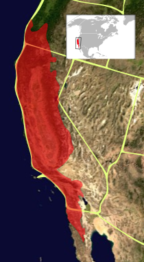
The California Floristic Province (CFP) is a floristic province with a Mediterranean-type climate located on the Pacific Coast of North America with a distinctive flora similar to other regions with a winter rainfall and summer drought climate like the Mediterranean Basin. This biodiversity hotspot is known for being the home of the Sierran giant sequoia tree and its close relative the coast redwood. In 1996, the Province was designated as a biodiversity hotspot allowing it to join ranks among 33 other areas in the world with many endemic species. To be named a biodiversity hotspot, an area has to contain species and plant life that cannot be found anywhere else in the world. The California Floristic Province is home to over 3,000 species of vascular plants, 60% of which are endemic to the province.

<span class="mw-page-title-main">Cape Floristic Region</span> Smallest of the six recognised floral kingdoms of the world

The Cape Floral Region is a floristic region located near the southern tip of South Africa. It is the only floristic region of the Cape Floristic Kingdom, and includes only one floristic province, known as the Cape Floristic Province.

The World Geographical Scheme for Recording Plant Distributions (WGSRPD) is a biogeographical system developed by the international Biodiversity Information Standards (TDWG) organization, formerly the International Working Group on Taxonomic Databases. The WGSRPD standards, like other standards for data fields in botanical databases, were developed to promote "the wider and more effective dissemination of information about the world's heritage of biological organisms for the benefit of the world at large". The system provides clear definitions and codes for recording plant distributions at four scales or levels, from "botanical continents" down to parts of large countries. The codes may be referred to as TDWG geographical codes. Current users of the system include the International Union for Conservation of Nature (IUCN), the Germplasm Resources Information Network (GRIN), and Plants of the World Online (POWO).

<span class="mw-page-title-main">North American Atlantic Region</span> Floristic region in the Holarctic kingdom

The North American Atlantic Region is a floristic region within the Holarctic Kingdom identified by Armen Takhtajan and Robert F. Thorne, spanning from the Atlantic and Gulf coasts to the Great Plains and comprising a major part of the United States and southeastern portions of Canada. It is bordered by the Circumboreal floristic region in the north, by the Rocky Mountain and Madrean floristic regions in the west and by the Caribbean floristic region of the Neotropical Kingdom in the south of Florida. The flora of the region comprises two endemic monotypic families, Hydrastidaceae and Leitneriaceae, and is characterized by about a hundred of endemic genera. The degree of species endemism is very high, many species are Tertiary relicts, which survived the Wisconsin glaciation and are now concentrated in the Appalachians and the Ozarks. A number of genera are shared only with the Canadian floristic province of the Circumboreal region. Moreover, as has long been noted, a large number of relict genera are shared with the relatively distant Eastern Asiatic Region and sometimes Southeast Asia. R. F. Thorne counted at least 74 genera restricted to eastern North America and Asia. The fossil record indicates that during the Tertiary period a warm temperate zone extended across much of the Northern Hemisphere, linking America to Asia.

The native flora of the United States includes about 17,000 species of vascular plants, plus tens of thousands of additional species of other plants and plant-like organisms such as algae, lichens and other fungi, and mosses. About 3,800 additional non-native species of vascular plants are recorded as established outside of cultivation in the U.S., as well as a much smaller number of non-native non-vascular plants and plant relatives. The United States possesses one of the most diverse temperate floras in the world, comparable only to that of China.

<span class="mw-page-title-main">Antarctic Floristic Kingdom</span> Geographic area with a relatively uniform composition of plant species in the Antarctic

The Antarctic Floristic Kingdom, also the Holantarctic Kingdom, is a floristic kingdom that includes most areas of the world south of 40°S latitude. It was first identified by botanist Ronald Good, and later by Armen Takhtajan. The Antarctic Floristic Kingdom is a classification in phytogeography, different from the Antarctic realm classification in biogeography, and from Antarctic flora genera/species classifications in botany.

<span class="mw-page-title-main">Eastern Asiatic Region</span> Floristic region in East Asia

The Eastern Asiatic Region is the richest floristic region within the Holarctic Kingdom and situated in temperate East Asia. It has been recognized as a natural floristic area since 1872 August Grisebach's volume Die Vegetation der Erde and later delineated by such geobotanists as Ludwig Diels, Adolf Engler, Ronald Good and Armen Takhtajan.

<span class="mw-page-title-main">Rocky Mountain Floristic Region</span>

The Rocky Mountain Floristic Region is a floristic region within the Holarctic Kingdom in western North America delineated by Armen Takhtajan and Robert F. Thorne. The region extends from Kodiak Island in Alaska to the San Francisco Bay Area and Sierra Nevada in California. It consists of two provinces, the Vancouverian, which comprises the coastal part of the region for its entire length, including the Pacific Coast Ranges, and the Rocky Mountain, which includes the Rocky Mountains and associated ranges. There are no endemic plant families in the region but many endemic genera and species.

<span class="mw-page-title-main">Madrean Region</span> Floristic region in the Holarctic Kingdom

The Madrean Region is a floristic region within the Holarctic Kingdom in North America, as delineated by Armen Takhtajan and Robert F. Thorne. It occupies arid or semiarid areas in the southwestern United States and northwestern Mexico and is bordered by the Rocky Mountain Floristic Region and North American Atlantic Region of the Holarctic Kingdom in the north and in the east, Caribbean Region of the Neotropical Kingdom in the south.

<span class="mw-page-title-main">Circumboreal Region</span> Floristic region in Eurasia and North America

The Circumboreal Region in phytogeography is a floristic region within the Holarctic Kingdom in Eurasia and North America, as delineated by such geobotanists as Josias Braun-Blanquet and Armen Takhtajan.

<span class="mw-page-title-main">Paleotropical Kingdom</span> One of the Earths six floristic kingdoms

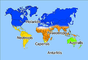
The Paleotropical Kingdom (Paleotropis) is a floristic kingdom composed of the tropical areas of Africa, Asia and Oceania, as proposed by Ronald Good and Armen Takhtajan. Part of its flora is inherited from the ancient supercontinent of Gondwana or exchanged later. These Gondwanan lineages are related to those in the Neotropical Kingdom, composed of the tropical areas of Central and South America. Flora from the Paleotropical Kingdom influenced the tropical flora of the Australian Kingdom. The kingdom is subdivided into five floristic subkingdoms according to Takhtajan and about 13 floristic regions. In this article the floristic subkingdoms and regions are given as delineated by Takhtajan.

The Saharo-Arabian Region is a floristic region of the Holarctic Kingdom proposed by Armen Takhtajan. The region is covered by hot deserts, semideserts and savanna.

<span class="mw-page-title-main">Great Basin Floristic Province</span> Floristic province in the Western United States

The Great Basin Floristic Province is a floristic province of the Madrean Subkingdom, in the Boreal Kingdom. It is located in the Western United States.

Vegetation classification is the process of classifying and mapping the vegetation over an area of the Earth's surface. Vegetation classification is often performed by state based agencies as part of land use, resource and environmental management. Many different methods of vegetation classification have been used. In general, there has been a shift from structural classification used by forestry for the mapping of timber resources, to floristic community mapping for biodiversity management. Whereas older forestry-based schemes considered factors such as height, species and density of the woody canopy, floristic community mapping shifts the emphasis onto ecological factors such as climate, soil type and floristic associations. Classification mapping is usually now done using geographic information systems (GIS) software.

The Atlantic and Gulf Coastal Plain Province is a coastal plain floristic province within the North American Atlantic Region, a floristic region within the Holarctic Kingdom. It lies to the east and south of the Appalachian Province. It encompasses the Atlantic coastal plain minus central and southern Florida, and the Gulf coastal plain. Although the precise definition varies, it extends as far north as Long Island or southern Nova Scotia, and as far south as eastern Texas or northeastern Mexico. Additionally, at the Mississippi Embayment the province stretches up to the confluence of the Ohio and Mississippi rivers in Cairo, Illinois.

References

  1. 1 2 Drude, O. (1890). Handbuch der Pflanzengeographie. Stuttgart: Engelhorn, , . French translation: Manuel de géographie botanique. Paris: P. Klincksieck, 1897. 552 p., .
  2. Braun-Blanquet, J. (1932). Plant sociology; the study of plant communities. New York and London, McGraw-Hill, .
  3. Linder, Lovett, Mutke, et al. (2005): A numerical re-evaluation of the sub-Saharan phytochoria. Biologiske Skrifter 55: 229-252.
  4. JOLY, C.A., AIDAR, M.P.M., KLINK, C.A., McGRATH, D.G., MOREIRA, A.G., MOUTINHO, P., NEPSTAD, D.C., OLIVEIRA, A.A.; POTT, A.; RODAL, M.J.N. & SAMPAIO, E.V.S.B. 1999. Evolution of the Brazilian phytogeography classification systems: implications for biodiversity conservation. Ci. e Cult. 51: 331-348.
  5. Magno Coutinho, L. (2006) O conceito de bioma. Acta bot. bras. 20(1): 13-23.
  6. Werger, M. J. A. & H. van Gils. 1976. Phytosociological classification problems in chorological border line areas. J. Biogeogr. 3: 49–54, .
  7. glossary Archived 2008-04-11 at the Wayback Machine from Bredenkamp, George J.; Granger, J. Ed; Hoffman, M. Timm; Lubke, Roy A.; Mckenzie, Bruce; Rebelo, A. (Tony) & Noel, van Rooyen (February 1998). Low, A. Barrie & Rebelo, A. (Tony) G. (eds.). Vegetation of South Africa, Lesotho and Swaziland: A companion to the Vegetation Map of South Africa, Lesotho and Swaziland. Department of Environmental Affairs and Tourism, Pretoria.
  8. Prance, G. T. (1989). American Tropical forests, in Ecosystems of the World, Vol. 14B. Tropical Rain Forest Ecosystems, (eds H. Lieth and M. J. A. Werger), Elsevier, Amsterdam, pp. 99–132, .
  9. Engler, A. (1879-1882). Versuch einer Entwicklungsgeschichte der Pflanzenwelt. 2 vols., Leipzig.
  10. Cox, C. B., Moore, P.D. & Ladle, R. J. 2016. Biogeography: an ecological and evolutionary approach. 9th edition. John Wiley & Sons: Hoboken, p. 10, .
  11. Engler, Adolf (1903). Syllabus der Pflanzenfamilien: eine Übersicht über das gesamte Pflanzensystem mit Berücksichtigung der Medicinal- und Nutzpflanzen nebst einer Übersicht über die Florenreiche und Florengebiete der Erde zum Gebrauch bei Vorlesungen und Studien über specielle und medicinisch-pharmaceutische Botanik (3rd ed.). Berlin: Gebrüder Borntraeger Verlag. p. 233. Retrieved 31 January 2014.
  12. de Candolle, Augustin (1820). Essai Élémentaire de Géographie Botanique. In: Dictionnaire des sciences naturelles, Vol. 18. Flevrault, Strasbourg, .
  13. Schouw, J. F. (1822). Grundtræk til en almindelig Plantegeographie. Copenhagen, Gyldendalske Boghandels Forlag. German translation: Grundzüge einer allgemeinen Pflanzengeographie, Berlin, 1823, .
  14. de Candolle, Alphonse (1855). Géographie botanique raisonnée. Paris: V. Masson, .
  15. Diels, L. (1908). Pflanzengeographie. Göschen, Leipzig, ; 5th ed. rev. 1958 (F. Mattick), De Gruyter, Berlin.
  16. Rikli, M. (1913). "Geographie der Pflanzen (Die Florenreiche)". In: Handwörterbuch der Naturwissenschaften 4:776–857, .
  17. Good, R. (1947). The Geography of Flowering Plants. Longmans, Green and Co, New York, . 2nd ed., 1953, .
  18. Takhtajan, A. 1969. Flowering plants: origin and dispersal. Transl. by C. Jeffrey. Oliver &. Boyd, Edinburgh. 310 pp. .
  19. Тахтаджян А. Л. Флористические области Земли / Академия наук СССР. Ботанический институт им. В. Л. Комарова. — Л.: Наука, Ленинградское отделение, 1978. — 247 с. — 4000 экз. DjVu, Google Books.
  20. Takhtajan, A. (1986). Floristic Regions of the World. (translated by T.J. Crovello & A. Cronquist). University of California Press, Berkeley, PDF, DjVu.
  21. Cox, C. B. (2001). The biogeographic regions reconsidered. Journal of Biogeography, 28: 511-523, .
  22. Frey, Wolfgang; Lösch, Rainer (2004). Lehrbuch der Geobotanik. München, Heidelberg: Elsevier, Spektrum. ISBN   3-8274-1193-9.
  23. Frey, Wolfgang; Lösch, Rainer (2010). Geobotanik: Pflanzen und Vegetation in Raum und Zeit (3 ed.). Heidelberg: Spektrum. ISBN   978-3-8274-2335-1.
  24. Liu, Y., Xu, X., Dimitrov, D., Pellissier, L., Borregaard, M. K., Shrestha, N., Su, X., Luo, A., Zimmermann, N. E., Rahbek, C., & Wang, Z. (2023). An updated floristic map of the world. Nature Communications, 14(1). https://doi.org/10.1038/s41467-023-38375-y
  25. Qian, H. (2024). Reassessing data quality underlying the recently updated floristic map of the world. Nature Communications, 15(1). https://doi.org/10.1038/s41467-024-47543-7
  26. Liu, Y., Xu, X., Dimitrov, D., Rahbek, C., & Wang, Z. (2024). Reply to: Reassessing data quality underlying the recently updated floristic map of the world. Nature Communications, 15(1). https://doi.org/10.1038/s41467-024-47544-6

Bibliography