
The Coral Sea Islands Territory is an external territory of Australia which comprises a group of small and mostly uninhabited tropical islands and reefs in the Coral Sea, north-east of Queensland, Australia. The only inhabited island is Willis Island. The territory covers 780,000 km2 (301,160 sq mi), most of which is ocean, extending east and south from the outer edge of the Great Barrier Reef and includes Heralds Beacon Island, Osprey Reef, the Willis Group and fifteen other reef/island groups. Cato Island is the highest point in the Territory.

Ulithi is an atoll in the Caroline Islands of the western Pacific Ocean, about 191 km (103 nmi) east of Yap, within Yap State.

Woleai, also known as Oleai, is a coral atoll of twenty-two islands in the western Caroline Islands in the Pacific Ocean, and forms a legislative district in the Yap State in the Federated States of Micronesia and is located approximately 57 kilometers west-northwest of Ifalik and 108 kilometers northeast of Eauripik. Woleai is also the name of the largest of the islets constituting the atoll, lying to the northeast.
Cosmoledo Atoll is an atoll of the Aldabra Group and belongs to the Outer Islands of the Seychelles, and is located 1,029 km (639 mi) southwest of the capital, Victoria, on Mahé Island.

Yap State is one of the four states of the Federated States of Micronesia (FSM). The other states are Kosrae State, Pohnpei State, and Chuuk State.
Amini is a census town in the Union Territory of Lakshadweep, India. It is also the name of the island where the town stands and of the atoll that contains that island. It lies 407 km (253 mi) west of the city of Kochi.
Satawal is a solitary coral atoll of one island with about 500 people on just over 1 km2 located in the Caroline Islands in the Pacific Ocean. It forms a legislative district in Yap State in the Federated States of Micronesia. Satawal is the easternmost island in the Yap island group and is located approximately 70 kilometers (43 mi) east of Lamotrek.

Poluwat, also Polowat, formerly Puluwat, is a coral atoll and a municipality of Chuuk state, Federated States of Micronesia.
Pattiw or Western Islands is the name of the westernmost area of the State of Chuuk in the Federated States of Micronesia, consisting of the three islands or atolls of Houk, Poluwat and Pollap, with a total land area of 7.17 square kilometres and a population of 2,736. Pattiw is one of three areas of Chuuk's Northwestern Region, Oksoritod. Poluwat is attached to the large Uranie Bank and lies in the northwest corner of the bank, while Houk (Pulusuk) marks the southeastern point of Manila Reef.

Sorol is a coral atoll of nine islands in the central Caroline Islands in the Pacific Ocean, and forms a legislative district in Yap State in the Federated States of Micronesia. Sorol is located approximately 150 kilometers (93 mi) south of Ulithi and 250 kilometers (160 mi) southeast of the island of Yap. Sorol has been uninhabited since the early 1980s. Sorol is a municipality with the state of Yap.

Ifalik is a coral atoll of four islands in the central Caroline Islands in the Pacific Ocean, and forms a legislative district in Yap State in the Federated States of Micronesia. Ifalik is located approximately 40 kilometers (25 mi) east of Woleai and 700 kilometers (430 mi) southeast of the island of Yap. The population of Ifalik was 561 in 2000, living on 1.5 km2. The primary islets of Ifalik are called Ella, Elangelap, Rawaii, and Flalap, which is the atoll's main island.
Gaferut Atoll is an outlying atoll in the State of Yap in the Federated States of Micronesia. The northernmost of the eastern group of islands of Yap, it is located 100 kilometers northeast of Faraulep and 790 kilometers east of Yap island.

Elato is a coral atoll of three islands in the central Caroline Islands in the Pacific Ocean, and forms a legislative district in Yap State in the Federated States of Micronesia. It is located approximately 10 kilometers (6.2 mi) west of Lamotrek. Its population was 96 in 2000, living on 0.5 km2 (0.19 sq mi).
Cherbaniani Reef, also known as Beleapani Reef, is a coral atoll belonging to the Amindivi Subgroup of islands of the Union Territory of Lakshadweep, India. It has a distance of 1,880 km (1,170 mi) south of the city of Delhi.
Byramgore Reef, also known as Chereapani Reef, is a coral atoll belonging to the Amindivi Subgroup of islands of the Union Territory of Lakshadweep, India. It has a distance of 1,940 km (1,210 mi) south of the city of Delhi.

The Hall Islands are a group of two large atolls in the northern part of the state of Chuuk, Federated States of Micronesia. In the broader sense, a third and smaller atoll is included.

Olimarao Atoll is an uninhabited atoll with a land area of 0.2 km2 in the State of Yap in the Federated States of Micronesia. It is located 36 kilometers northwest of Elato and 860 kilometers southeast of Yap island. Olimarao belongs administratively to Elato.

Fayu Atoll is an uninhabited atoll in the state of Chuuk, Federated States of Micronesia. It is located 36 km to the west of Nomwin Atoll and 104 km north of Chuuk Lagoon.

Wa are traditional sailing outrigger canoes of the Caroline Islands, Palau, and Yap. They have a single outrigger. They are similar to the sakman of the Northern Marianas.
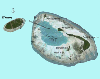
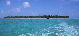
Saint Joseph Atoll is part of the Amirante Islands group, which are in the Outer Islands coral archipelago of the Seychelles islands and nation. The atoll is located southwest of the granitic Inner Seychelles archipelago, with a distance of 248 km south of Victoria, Seychelles.

