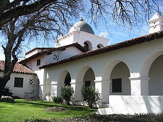
The Hacienda is the current name for a hotel in Monterey County, California, that was completed in 1930 for use by William Randolph Hearst as temporary housing for his employees and guests and headquarters for activities taking place on the surrounding land. The lodge building, designed by architect Julia Morgan, replaced and expanded upon an earlier wooden structure known as the Milpitas Ranch House which was destroyed by fire in the 1920s. The 1930 hotel has also been known as Milpitas Hacienda, Hacienda Guest Lodge and Milpitas Ranchhouse, under which name the property was placed in the National Register of Historic Places on December 2, 1977.
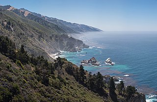
Big Sur is a rugged and mountainous section of the Central Coast of California between Carmel and San Simeon, where the Santa Lucia Mountains rise abruptly from the Pacific Ocean. It is frequently praised for its dramatic scenery. Big Sur has been called the "longest and most scenic stretch of undeveloped coastline in the contiguous United States", a sublime "national treasure that demands extraordinary procedures to protect it from development", and "one of the most beautiful coastlines anywhere in the world, an isolated stretch of road, mythic in reputation". The views, redwood forests, hiking, beaches, and other recreational opportunities have made Big Sur a popular destination for visitors from across the world. With 4.5 to 7 million visitors annually, it is among the top tourist destinations in the United States, comparable to Yosemite National Park, but with considerably fewer services, parking, roads, and related infrastructure.

The Central Coast is an area of California, roughly spanning the coastal region between Point Mugu and Monterey Bay. It lies northwest of Los Angeles County and south of San Mateo and Santa Clara counties, and includes the rugged, undeveloped stretch of coastline known as Big Sur. From south to north, there are six counties that make up the Central Coast: Ventura, Santa Barbara, San Luis Obispo, Monterey, San Benito, and Santa Cruz.

San Simeon is a village and Census-designated place on the Pacific coast of San Luis Obispo County, California, United States. Its position along State Route 1 is about halfway between Los Angeles and San Francisco, each of those cities being roughly 230 miles (370 km) away. A key feature of the area is Hearst Castle, a hilltop mansion built for William Randolph Hearst in the early 20th century that is now a tourist attraction. The area is also home to a large northern elephant seal rookery, known as the Piedras Blancas rookery, located 7 miles (11 km) north of San Simeon on Highway 1. The area is also home to an invasive zebra population of slightly over 100.

Hearst Castle, known formally as La Cuesta Encantada, is a historic estate in San Simeon, located on the Central Coast of California. Conceived by William Randolph Hearst, the publishing tycoon, and his architect Julia Morgan, the castle was built between 1919 and 1947. Today, Hearst Castle is a museum open to the public as a California State Park and registered as a National Historic Landmark and California Historical Landmark.

Año Nuevo State Park is a state park of California, United States, encompassing Año Nuevo Island and Año Nuevo Point, which are known for their pinniped rookeries. Located in San Mateo County, the low, rocky, windswept point juts out into the Pacific Ocean about 55 miles (89 km) south of San Francisco and the Golden Gate. Año Nuevo State Natural Reserve, formerly a separate unit of the California state park system, was merged into Año Nuevo State Park in October 2008. The coastal geographic center, or coastal-midpoint of California is located at the Northern end of this park at N 37°09′58″, W 122°21'40", as the absolute geographic center of California falls at N 37°09′58″, W 119°26′58″W.

William Randolph Hearst Memorial State Beach is located near the historic town of San Simeon along California State Route 1, in San Luis Obispo County, California, United States. It is named for newspaper magnate William Randolph Hearst (1863–1951), whose family is closely associated with the area.

Hearst San Simeon State Park is a state park of California, United States, preserving rocky coast and rare habitats. It is located between Cambria and San Simeon. The 3,409-acre (1,380 ha) park was first established in 1932. The park includes the Santa Rosa Creek Natural Preserve, the San Simeon Natural Preserve and the Pa-nu Cultural Preserve, which were established in 1990.

Piedras Blancas Light Station is located at Point Piedras Blancas, about 5.5 miles (8.9 km) west by northwest of San Simeon, California. It was added to the California Coastal National Monument in 2017.
Rancho Santa Rosa was a 13,184-acre (53.35 km2) Mexican land grant in present-day San Luis Obispo County, California.

Rancho Piedra Blanca was a large, 48,806-acre (197.51 km2) Mexican land grant in present-day San Luis Obispo County, California given in 1840 by Governor Juan Alvarado to José de Jesús Pico. The name means "white rock" and refers to rocks painted white by its bird population. The grant extended south along the Pacific Coast below Big Sur from Ragged Point to Pico Creek, where it adjoins Rancho San Simeon. The land grant includes the original townsite and post office for San Simeon, the Hearst Ranch headquarters, and Hearst Castle.
Rancho San Simeon was a 4,469-acre (18.09 km2) Mexican land grant in present-day San Luis Obispo County, California given in 1842 by Governor Juan Alvarado to José Ramón Estrada. The grant extended along the Pacific Coast from Rancho Piedra Blanca at Pico Creek, south along the coast to San Simeon Creek, and includes the present-day townsite of San Simeon Acres.

Cambria State Marine Conservation Area (SMCA) is a marine protected area located off the coast of the city of Cambria, California on California’s central coast in San Luis Obispo County, California. The marine protected area covers 6.26 square miles (16.2 km2). Within the SMCA recreational fishing and take is allowed while commercial fishing and take of all living marine resources is prohibited.

Piedras Blancas State Marine Reserve (SMR) and Piedras Blancas State Marine Conservation Area (SMCA) are two adjoining marine protected areas that lie offshore of San Luis Obispo County on California’s central coast. The combined area of these marine protected areas is 19.68 square miles (51.0 km2). The SMR protects all marine life within its boundaries. Fishing and take of all living marine resources is prohibited. Within the SMCA fishing and take of all living marine resources is prohibited except the commercial and recreational take of salmon and albacore.
White Rock (Cambria) State Marine Conservation Area (SMCA) is a marine protected area located off the coast of the city of Cambria, California on California’s central coast. The marine protected area covers 2.32 square miles (6.0 km2). Within the SMCA the take of all living marine resources is prohibited except the commercial take of giant kelp and bull kelp under certain conditions.
The Hearst Ranch is composed of two cattle ranches in central California. The best known is the original Hearst Ranch, which surrounds Hearst Castle and comprises about 80,000 acres (320 km2). George Hearst (1820–1891) bought over 30,000 acres (120 km2) of Rancho Piedra Blanca, an 1840 Mexican land grant, in the late 19th century. He also bought most of Rancho San Simeon, and part of Rancho Santa Rosa, two other adjacent land grants.

The Sebastian Store is a California Historical Landmark (#726). It is the oldest store building along the north coast of San Luis Obispo County. It was built in the 1860s at Whaling Point, California, one-half mile to the west of its current location and has been in its present location since 1878. The Sebastian family has operated the store for over half a century.

Ragged Point is a headland on California's Central Coast. It is located at the southern end of Big Sur in northern San Luis Obispo County. The Ragged Point Inn and Resort is located in the area, which, as with much of Big Sur, features seaside cliffs, beaches, and hiking trails.

Big Sur Coast Highway is a section of California State Route 1 through the Big Sur region of California that is widely considered to be one of the most scenic driving routes in the United States, if not the world. It is both a National Scenic Highway and a California Scenic Highway, and was described by Australian painter Francis McComas as the "greatest meeting of land and water in the world". Condé Nast Traveler named State Route 1 through Big Sur one of the top ten world-famous streets, comparable to Broadway in New York City and the Champs-Élysées in Paris. The road itself is a destination for visitors.

