
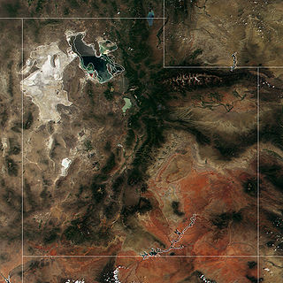
The Black Rock Desert is a semi-arid region of lava beds and playa, or alkali flats, situated in the Black Rock Desert–High Rock Canyon Emigrant Trails National Conservation Area, a silt playa 100 miles (160 km) north of Reno, Nevada that encompasses more than 300,000 acres (120,000 ha) of land and contains more than 120 miles (200 km) of historic trails. It is in the northern Nevada section of the Great Basin with a lakebed that is a dry remnant of Pleistocene Lake Lahontan.

The Humboldt River is an extensive river drainage system located in north-central Nevada. It extends in a general east-to-west direction from its headwaters in the Jarbidge, Independence, and Ruby Mountains in Elko County, to its terminus in the Humboldt Sink, approximately 225 miles away in northwest Churchill County. Most estimates put the Humboldt River at 290 miles (470 km) long however, due to the extensive meandering nature of the river, its length is more closely estimated at 380 miles (612 km). It is located within the Great Basin Watershed and is the third longest river in the watershed behind the Bear River at 355 miles (570 km) and the Sevier River at 325 miles (523 km). The Humboldt River Basin is the largest sub-basin of the Great Basin encompassing an area of 16,840 square miles (43,615 km2). It is the only major river system wholly contained within the state of Nevada.

The California Trail was an emigrant trail of about 1,600 mi (2,600 km) across the western half of the North American continent from Missouri River towns to what is now the state of California. After it was established, the first half of the California Trail followed the same corridor of networked river valley trails as the Oregon Trail and the Mormon Trail, namely the valleys of the Platte, North Platte, and Sweetwater rivers to Wyoming. The trail has several splits and cutoffs for alternative routes around major landforms and to different destinations, with a combined length of over 5,000 mi (8,000 km).

Mount Charleston, including Charleston Peak at 11,916 feet (3,632 m), is the highest mountain in both the Spring Mountains and Clark County, in Nevada, United States. It is the eighth-highest mountain in the state. Well separated from higher peaks by large, low basins, Charleston Peak is the most topographically prominent peak in Nevada, and the eighth-most-prominent peak in the contiguous United States. It is one of eight ultra-prominent peaks in Nevada. It is located about 35 miles (56 km) northwest of Las Vegas within the Mount Charleston Wilderness, which is within the Spring Mountains National Recreation Area of the Humboldt–Toiyabe National Forest.
The Great Salt Lake Desert is a large dry lake in northern Utah, United States, between the Great Salt Lake and the Nevada border. It's a subregion of the larger Great Basin Desert, and noted for white evaporite Lake Bonneville salt deposits including the Bonneville Salt Flats.
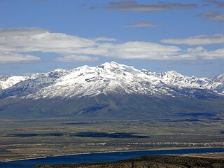
Ruby Dome is the highest mountain in both the Ruby Mountains and Elko County, in Nevada, United States. It is the twenty-seventh-highest mountain in the state, and also ranks as the thirteenth-most topographically prominent peak in the state. The peak is located about 21 miles (34 km) southeast of the city of Elko within the Ruby Mountains Ranger District of the Humboldt-Toiyabe National Forest. The mountain rises from a base elevation of about 6,000 feet (1,800 m) to a height of 11,387 feet (3,471 m). It is the highest mountain for over 90 miles in all directions.

Hole in the Mountain Peak is the highest mountain in the East Humboldt Range of mountains in Elko County, Nevada, United States. It is the thirty-fifth highest mountain in the state, and also ranks as the eleventh-most topographically prominent peak in the state. It is located within the East Humboldt Wilderness of the Humboldt–Toiyabe National Forest and is 11,311 feet (3,448 m) high. The peak is 35 miles (56 km) east of Elko and 14 miles (23 km) southwest of Wells, making it a rather prominent feature of the drive along Interstate 80 in Elko County. The U.S. Board on Geographic Names lists two variant names, Mount Bonpland and Mount Bonplant.

The Pilot Range is a mountain range straddling the border of Box Elder County, Utah and Elko County, Nevada, United States. Lying 50 miles west of the Great Salt Lake, the range forms part of the north-west border of the Great Salt Lake Desert. The range reaches a maximum elevation of 10,716 feet at the summit of Pilot Peak. Most of the range is public Bureau of Land Management land and thus has no access restrictions. Its principal uses are mining, livestock grazing, and seasonal elk and deer hunting.
The Verdi Peaks, officially just Verdi Peak, are a group of three mountain peaks in the Ruby Mountains of Elko County, Nevada, United States. The highest peak is the fiftieth-highest in the state. The peaks are located on the edge of the Ruby Mountains Wilderness, within the Ruby Mountains Ranger District of the Humboldt-Toiyabe National Forest. They rise from the head of Talbot Canyon above Verdi Lake, and are a prominent part of the east wall of Lamoille Canyon above the Terraces Picnic Area. The two southern summits are directly on the Ruby Crest 5,000 feet (1,500 m) above the Ruby Valley to the east. The central summit is the highest of the three and is located about 25 miles (40 km) southeast of the city of Elko.

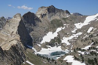
Snow Lake Peak is the fifth-highest named mountain of the Ruby Mountains and the seventh-highest in Elko County, in Nevada, United States. It is the forty-second-highest mountain in the state. It rises from the head of Box Canyon, is part of the headwall of Thomas Canyon, and is a prominent part of the west wall of Lamoille Canyon above Lamoille and Dollar Lakes. The peak is located within the Ruby Mountains Wilderness of the Ruby Mountains Ranger District in the Humboldt-Toiyabe National Forest.

Arc Dome is the highest mountain of the Toiyabe Range in northwestern Nye County, Nevada, United States. It is the thirteenth-highest mountain in the state. Arc Dome also ranks as the second-most topographically prominent peak in Nye County and the eighth-most prominent peak in the state. The peak is located about 53 miles (85 km) north of the community of Tonopah, within the Arc Dome Wilderness of the Humboldt-Toiyabe National Forest.

Red Lake Peak is believed to be the vantage point from which John C. Fremont and Charles Preuss made the first recorded sighting of Lake Tahoe by Europeans in February 1844 as Fremont's exploratory expedition made a desperate crossing of the Sierra Nevada through what is now Carson Pass on their way to obtain provisions at Sutter's Fort. The peak lies just north of the pass and generally northwest of the small lake east of the pass for which the peak is named. Lake Tahoe is visible to the north from the peak.

Mount Rose is the highest mountain in Washoe County, within the Carson Range of Nevada, United States. It ranks thirty-seventh among the most topographically prominent peaks in the state. It is also both the highest and most topographically prominent peak of the greater Sierra Nevada range within the state of Nevada, and the third most topographically prominent peak in the Sierra Nevada overall. It is located in the Mount Rose Wilderness of the Humboldt-Toiyabe National Forest. An extinct volcano, the mountain is in between Lake Tahoe and Reno. State Route 431 traverses Mount Rose Summit southeast of Mount Rose. Due to the high elevation, most of the precipitation that falls on the mountain is snow. The view from Mount Rose, facing east is the Truckee Meadows area is the second largest population center in Nevada.

The Goose Creek Mountains are a mountain range in Box Elder County, Utah. They are also partly in Elko County, Nevada. It is the least topographically prominent of Utah's peaks with more than 609.6 ft (2000 ft) of prominence.

The Trout Creek Mountains are a remote, semi-arid Great Basin mountain range mostly in southeastern Oregon and partially in northern Nevada in the United States. The range's highest point is Orevada View Benchmark, 8,506 feet (2,593 m) above sea level, in Nevada. Disaster Peak, elevation 7,781 feet (2,372 m), is another prominent summit in the Nevada portion of the mountains.

Matterhorn is the highest mountain in the Jarbidge Mountains of northern Elko County, Nevada, United States. It is the fifteenth-most topographically prominent peak in the state. The summit is located in the Jarbidge Wilderness, which is administered by the Jarbidge Ranger District of the Humboldt-Toiyabe National Forest. Its name is derived from the Matterhorn in the Alps of Europe, due mainly to the cliffs located immediately adjacent to the summit on the north and northeast.

Star Peak is both the highest and most topographically prominent mountain in both the Humboldt Range and Pershing County in Nevada, United States. It is the sixth-most topographically prominent peak in Nevada. The peak is on public land administered by the Bureau of Land Management and has no access restrictions.

Highland Peak is a prominent 10,936-foot-elevation mountain summit located in the Sierra Nevada mountain range, in Alpine County of northern California, United States. It is situated 3.5 miles east of Ebbetts Pass in the Carson-Iceberg Wilderness, on land managed by Humboldt–Toiyabe National Forest. Although it ranks as the 680th highest summit in California, it ranks 36th highest of those with at least 500 meters of topographic prominence. Highland Peak has a subsidiary South Peak, with one-half mile separation between summits. The Pacific Crest Trail traverses the western foot of this mountain, providing an approach option.


