Pine Knot, Kentucky

Last updated
Pine Knot, Kentucky
KYMap-doton-PineKnot.PNG
Location in Kentucky
Coordinates: 36°39′41″N84°26′25″W / 36.66139°N 84.44028°W / 36.66139; -84.44028 Coordinates: 36°39′41″N84°26′25″W / 36.66139°N 84.44028°W / 36.66139; -84.44028
Country United States
State Kentucky
County McCreary
Area
[1]
  Total6.47 sq mi (16.75 km2)
  Land6.40 sq mi (16.59 km2)
  Water0.06 sq mi (0.16 km2)
Elevation
1,421 ft (433 m)
Population
 (2020) [2]
  Total1,380
  Density215.49/sq mi (83.19/km2)
Time zone UTC-5 (Eastern (EST))
  Summer (DST) UTC-4 (EDT)
ZIP code
42635
Area code 606
FIPS code 21-61122
GNIS feature ID0514591

Pine Knot is an unincorporated community and census-designated place (CDP) in McCreary County, Kentucky, United States. The population was 1,380 at the 2020 census, [2] down from 1,621 in 2010.

Contents

Geography

Pine Knot is located in southern McCreary County at 36°39′41″N84°26′25″W / 36.66139°N 84.44028°W / 36.66139; -84.44028 (36.661333, -84.440412). [3] It is bordered to the north by Stearns and to the south by Strunk.

U.S. Route 27 passes through Pine Knot east of the original center of town. The highway leads north 5 miles (8 km) to Whitley City, the McCreary county seat, and 35 miles (56 km) to Somerset, while to the south it leads 12 miles (19 km) to Oneida, Tennessee. Kentucky Route 92 intersects US 27 in Pine Knot, leading east 19 miles (31 km) to Williamsburg. KY 92 turns north with US 27 as far as Stearns.

According to the U.S. Census Bureau, the Pine Knot CDP has a total area of 6.47 square miles (16.8 km2), of which 0.06 square miles (0.16 km2), or 0.96%, are water. [1] The community sits on a ridge which drains west to the Smith Fork, north to Laurel Creek, and east to Perkins Creek. Laurel Creek and Perkins Creek are tributaries of Marsh Creek, a north-flowing tributary of the Cumberland River, while the Smith Fork is a tributary of Roaring Paunch Creek, which flows to the South Fork of the Cumberland River.

Demographics

Historical population
CensusPop.Note
1980 1,389
1990 1,54911.5%
2000 1,6808.5%
2010 1,621−3.5%
2020 1,380−14.9%
U.S. Decennial Census [4]

As of the census [5] of 2000, there were 1,680 people, 584 households, and 390 families residing in the CDP. The population density was 263.2 inhabitants per square mile (101.6/km2). There were 653 housing units at an average density of 102.3 per square mile (39.5/km2). The racial makeup of the CDP was 90.95% White, 5.71% African American, 0.42% Native American, 0.06% Asian, 1.37% from other races, and 1.49% from two or more races. Hispanic or Latino of any race were 2.32% of the population.

There were 584 households, out of which 32.2% had children under the age of 18 living with them, 50.7% were married couples living together, 12.8% had a female householder with no husband present, and 33.2% were non-families. 30.5% of all households were made up of individuals, and 8.9% had someone living alone who was 65 years of age or older. The average household size was 2.39 and the average family size was 2.97.

In the CDP, the population was spread out, with 27.4% under the age of 18, 14.8% from 18 to 24, 22.4% from 25 to 44, 22.4% from 45 to 64, and 12.9% who were 65 years of age or older. The median age was 32 years. For every 100 females, there were 114.0 males. For every 100 females age 18 and over, there were 108.5 males.

The median income for a household in the CDP was $13,777, and the median income for a family was $20,313. Males had a median income of $19,539 versus $12,092 for females. The per capita income for the CDP was $8,715. About 31.2% of families and 38.5% of the population were below the poverty line, including 38.6% of those under age 18 and 13.7% of those age 65 or over.

Government and infrastructure

The Federal Bureau of Prisons United States Penitentiary, McCreary, is in McCreary County, 3 miles (5 km) east of Pine Knot. [6] [7]

Transportation

McCreary County Airport is located in the county, 3 miles (5 km) northeast of Pine Knot. [7]

Related Research Articles

<span class="mw-page-title-main">McCreary County, Kentucky</span> County in Kentucky, United States

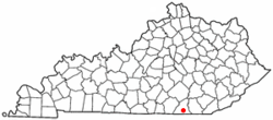
McCreary County is a county located in the U.S. state of Kentucky. As of the 2020 census, the population was 16,888. Its county seat is Whitley City. The county is named for James B. McCreary, a Confederate war soldier and two-time Governor of Kentucky. During his second term as governor, McCreary County was created by the Legislature and was named in his honor.

<span class="mw-page-title-main">Pine, Arizona</span> CDP in Gila County, Arizona

Pine is an unincorporated community and census-designated place (CDP) in Gila County, Arizona, United States. The population was 1,963 at the 2010 census. Pine was established by four Mormon families in 1879.

<span class="mw-page-title-main">Whiskey Creek, Florida</span> Census-designated place in Florida, United States

Whiskey Creek is a census-designated place (CDP) in Lee County, Florida, United States. The population was 4,842 at the 2020 census. It is part of the Cape Coral-Fort Myers, Florida Metropolitan Statistical Area.

<span class="mw-page-title-main">Claryville, Kentucky</span> Census-designated place in Kentucky, United States

Claryville is an unincorporated community and census-designated place (CDP) in Campbell County, Kentucky, United States. The population was 2,355 at the 2010 census.

<span class="mw-page-title-main">South Wallins, Kentucky</span> Census-designated place in Kentucky, United States

South Wallins is an unincorporated community and census-designated place (CDP) in Harlan County, Kentucky, United States. The population was 859 at the 2010 census, down from 996 at the 2000 census.

<span class="mw-page-title-main">McRoberts, Kentucky</span> Census-designated place in Kentucky, United States

McRoberts is an unincorporated community and census-designated place (CDP) in Letcher County, Kentucky, United States. The population was 784 at the 2010 United States Census, down from 921 at the 2000 census. McRoberts is in the Eastern Kentucky Coalfield region.

<span class="mw-page-title-main">Stearns, Kentucky</span> CDP in Kentucky, United States

Stearns is a census-designated place (CDP) in McCreary County, Kentucky, United States. The population was 1,586 at the 2000 census. It was founded by Justus Smith Stearns.

<span class="mw-page-title-main">Whitley City, Kentucky</span> CDP in Kentucky, United States

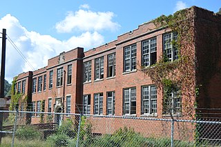
Whitley City is a census-designated place (CDP) in McCreary County, Kentucky, United States. The population was 1,170 at the 2010 census. Despite its name, it is not an incorporated city; however, it is the county seat of McCreary County. Whitley City is one of two non-city county seats in Kentucky. This is due to McCreary County not having any cities. Whitley City is one of the poorest places in the United States with a population greater than 1,000.

<span class="mw-page-title-main">Elkhorn City, Kentucky</span> City in Kentucky, United States

Elkhorn City is a home rule-class city in Pike County, Kentucky, in the United States. The population was 982 at the 2010 census. The city is located in proximity to the Breaks Interstate Park.

Lake Arrowhead is a census-designated place (CDP) in the towns of Waterboro and Limerick in York County, Maine, United States. The population was 3,071 at the 2010 census. The CDP corresponds to the area covered by the Lake Arrowhead Community, a large subdivision begun in the 1960s which surrounds Lake Arrowhead, an artificial lake on the Little Ossipee River. The community is part of the Portland–South Portland–Biddeford, Maine Metropolitan Statistical Area.

<span class="mw-page-title-main">Standing Pine, Mississippi</span> Census-designated place in Mississippi, United States

Standing Pine is a census-designated place (CDP) in Leake County, Mississippi, United States. It is one of the eight communities of the Mississippi Band of Choctaw Indians Reservation, and the population is 94% Choctaw. The total population of the CDP was 517 at the 2020 census.

<span class="mw-page-title-main">Willow Creek, Montana</span> Census-designated place in Gallatin County, Montana, United States.

Willow Creek is a census-designated place (CDP) in Gallatin County, Montana, United States. The population was 210 at the 2010 census. It is part of the Bozeman, MT Micropolitan Statistical Area.

<span class="mw-page-title-main">McLeansville, North Carolina</span> Census-designated place in North Carolina, United States

McLeansville is an unincorporated community and census-designated place (CDP) in Guilford County, North Carolina, United States. The population was 1,021 at the 2010 census.

<span class="mw-page-title-main">Clarence, Pennsylvania</span> Census-designated place in Pennsylvania, United States

Clarence is a census-designated place (CDP) in Centre County, Pennsylvania, United States. It is part of the State College, Pennsylvania Metropolitan Statistical Area. The population was 626 at the 2010 census.

<span class="mw-page-title-main">McAlisterville, Pennsylvania</span> Census-designated place in Pennsylvania, United States

McAlisterville is an unincorporated community and census-designated place (CDP) in Fayette Township, Juniata County, Pennsylvania, United States. The population was 971 at the 2010 census.

<span class="mw-page-title-main">Salmon Creek, Washington</span> Census-designated place in Washington, United States

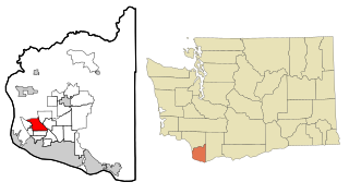
Salmon Creek is a census-designated place (CDP) in Clark County, Washington, United States. The population was 19,686 at the 2010 census, up from 16,767 at the 2000 census.

<span class="mw-page-title-main">Alum Creek, West Virginia</span> Census-designated place in West Virginia, United States

Alum Creek is a census-designated place (CDP) in Kanawha and Lincoln counties along the Coal River in the U.S. state of West Virginia. It includes the unincorporated communities of Alum Creek, Forks of Coal, and Priestley. The CDP had a population of 1,749 at the 2010 census, down from 1,839 at the 2000 census.

<span class="mw-page-title-main">Holden, West Virginia</span> Census-designated place in West Virginia, United States

Holden is a census-designated place (CDP) in Logan County, West Virginia, United States. The population was 876 at the 2010 census, down from 1,105 in 2000. The CDP contains the unincorporated communities of Holden, Beebe, Frogtown, Sycamore, Diamond, and Davis, all in the valley of Copperas Mine Fork.

<span class="mw-page-title-main">Mount Gay-Shamrock, West Virginia</span> Census-designated place in West Virginia, United States

Mount Gay-Shamrock is a census-designated place (CDP) in Logan County, West Virginia, United States.

<span class="mw-page-title-main">North Corbin, Kentucky</span> Census-designated place in Kentucky, United States

North Corbin is a census-designated place (CDP) in Laurel and Knox counties in the U.S. state of Kentucky. The population was 1,727 at the 2020 census down from 1,773 at the 2010 census. The census bureau also lists the Laurel County portion of North Corbin as a CCD with a population of 10,729.

References

  1. 1 2 "2022 U.S. Gazetteer Files: Kentucky". United States Census Bureau. Retrieved May 9, 2023.
  2. 1 2 "P1. Race – Pine Knot CDP, Kentucky: 2020 DEC Redistricting Data (PL 94-171)". U.S. Census Bureau. Retrieved May 9, 2023.
  3. "US Gazetteer files: 2010, 2000, and 1990". United States Census Bureau. 2011-02-12. Retrieved 2011-04-23.
  4. "Census of Population and Housing". Census.gov. Retrieved June 4, 2016.
  5. "U.S. Census website". United States Census Bureau . Retrieved 2008-01-31.
  6. "USP McCreary Contact Information." Federal Bureau of Prisons. Retrieved on February 22, 2011. "USP MCCREARY U.S. PENITENTIARY 330 FEDERAL WAY PINE KNOT, KY 42635."
  7. 1 2 "Pine Knot CDP, Kentucky [ permanent dead link ]." U.S. Census Bureau. Retrieved on February 22, 2011.