Pine Valley is a community and census-designated place (CDP) in the Cuyamaca Mountains of the Mountain Empire area, in southeastern San Diego County, California. The population was 1,510 at the 2010 census, up from 1,501 at the 2000 census.

Pine Village is a town in Adams Township, Warren County, in the U.S. state of Indiana. The population was 217 at the 2010 census.

Shaler Township is a township in Allegheny County in the U.S. state of Pennsylvania. It consists of much of the community of Glenshaw and several neighboring communities. The population was 28,757 at the 2010 census. It is part of the Pittsburgh metropolitan area.

U.S. Route 20 or U.S. Highway 20 (US 20) is an east–west United States Numbered Highway that stretches from the Pacific Northwest east to New England. The "0" in its route number indicates that US 20 is a major coast-to-coast route. Spanning 3,365 miles (5,415 km), it is the longest road in the United States, and, in the east, the route is roughly parallel to that of the newer Interstate 90 (I-90), which is the longest Interstate Highway in the U.S. There is a discontinuity in the official designation of US 20 through Yellowstone National Park, with unnumbered roads used to traverse the park.

Pinus strobus, commonly called the eastern white pine, northern white pine, white pine, Weymouth pine (British), and soft pine is a large pine native to eastern North America. It occurs from Newfoundland, Canada west through the Great Lakes region to southeastern Manitoba and Minnesota, United States, and south along the Appalachian Mountains and upper Piedmont to northernmost Georgia and perhaps very rarely in some of the higher elevations in northeastern Alabama. It is considered rare in Indiana.

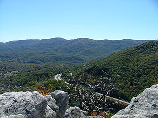
The Cumberland Mountains are a mountain range in the southeastern section of the Appalachian Mountains. They are located in western Virginia, southwestern West Virginia, the eastern edges of Kentucky, and eastern middle Tennessee, including the Crab Orchard Mountains. Their highest peak, with an elevation of 4,223 feet (1,287 m) above mean sea level, is High Knob, which is located near Norton, Virginia.

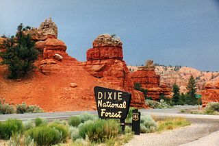
Dixie National Forest is a United States National Forest in Utah with headquarters in Cedar City. It occupies almost two million acres (8,000 km²) and stretches for about 170 miles (270 km) across southern Utah. The largest national forest in Utah, it straddles the divide between the Great Basin and the Colorado River. In descending order of forestland area it is located in parts of Garfield, Washington, Iron, Kane, Wayne, and Piute counties. The majority of forest acreage lies in Garfield County.

Inyo National Forest is a United States National Forest covering parts of the eastern Sierra Nevada of California and the White Mountains of California and Nevada. The forest hosts several superlatives, including Mount Whitney, the highest point in the contiguous United States; Boundary Peak, the highest point in Nevada; and the Ancient Bristlecone Pine Forest, which protects the oldest living trees in the world. The forest, encompassing much of the Owens Valley, was established by Theodore Roosevelt as a way of sectioning off land to accommodate the Los Angeles Aqueduct project in 1907, making the Inyo National Forest one of the least wooded forests in the U.S. National Forest system.

The Western Pennsylvania Interscholastic Athletic League is an interscholastic athletic association in Western Pennsylvania. It is District 7 of the Pennsylvania Interscholastic Athletic Association.

Shades State Park is a state park in Montgomery, Parke, and Fountain Counties in Indiana. It is located 47 miles (76 km) west-northwest of Indianapolis, Indiana. In 2018–2019, Shades received nearly 87,000 visitors.

Kampinos National Park is a National Park in east-central Poland, in Masovian Voivodeship, on the north-west outskirts of Warsaw. It's Poland second biggest national park by area and the only national park in the Mazovian Voivodeship. It has a sister park agreement with Indiana Dunes National Park, Indiana, United States.

Pine Township is one of twelve townships in Warren County, Indiana, United States. According to the 2010 census, its population was 481 and it contained 213 housing units.

Pine Township is one of twelve townships in Porter County, Indiana. As of the 2010 census, its population was 2,709.

Southeast Township is one of ten townships in Orange County, Indiana, United States. As of the 2010 census, its population was 1,603 and it contained 717 housing units.

Pine Valley Mountain Wilderness is a 50,232-acre (203.28 km2) wilderness area located in the Dixie National Forest in the U.S. state of Utah. It is the fourth-largest wilderness area located entirely within the state. The wilderness designation protects the Pine Valley Mountain range, a large rock outcrop surrounded by desert. The Pine Valley Mountains form the Pine Valley Laccolith, one of the largest laccoliths in the United States. Elevations in the wilderness range from 6,000 feet (1,800 m) to 10,365 feet (3,159 m) at the summit of Signal Peak.

U.S. Route 20 (US 20) in Indiana is a main east–west highway that is parallel to the Indiana Toll Road. The western terminus of US 20 is at the Illinois state line and the eastern terminus is at the Ohio state line. US 20 through Whiting, East Chicago, and Gary is concurrent with US 12 twice. The route varies between one-way, two-lane, and four-lane streets, in northwestern Indiana. From the east side of Gary to west of South Bend, US 20 is a four-lane undivided highway. The route then heads around the west and south sides of South Bend and Elkhart as a four-lane limited access divided highway. East of State Road 15 (IN-15), US 20 is two-lane rural highway.

Pine Ridge is an unincorporated community in Fayette Township, Vigo County, in the U.S. state of Indiana. It is part of the Terre Haute metropolitan area.

The Pittsburgh–New Castle–Weirton, PA–OH–WV Combined Statistical Area is a 12-county combined statistical (CSA) in the United States. The largest and principal in the area is Pittsburgh, Pennsylvania, but the CSA includes population centers from three states: Pennsylvania, West Virginia, and Ohio.


