St. Mary's County, established in 1637, is a county located in the U.S. state of Maryland. As of the 2020 census, the population was 113,777. Its county seat is Leonardtown. The name is in honor of Mary, the mother of Jesus. St. Mary's County comprises the California-Lexington Park, Maryland Metropolitan Statistical Area, which also is included in the Washington-Baltimore-Arlington, DC-MD-VA-WV-PA Combined Statistical Area. It is part of the Southern Maryland region. The county was the home to the first Maryland Colony, and the first capital of the Colony of Maryland. Settled by English Catholics, it is considered to be the birthplace of religious freedom in North America, at a time when the British colonies were settled primarily by Protestants. The county is home to the Patuxent River Naval Air Station and St. Mary's College of Maryland. Traditionally, St. Mary's County has been known for its unique and historic culture of Chesapeake Bay tidewater farming, fishing, and crabbing communities. But with the advent of the military bases, growth of an extensive defense contractor presence, and the growth of St. Mary's College of Maryland, as well as increasing numbers of long-distance Washington, D.C. commuters, it has been undergoing a decades-long transformation which has seen the county's population double since 1970.

The Seven Foot Knoll Light was built in 1855 and is the oldest screw-pile lighthouse in Maryland. It was located atop Seven Foot Knoll in the Chesapeake Bay until it was replaced by a modern navigational aid and relocated to Baltimore's Inner Harbor as a museum exhibit.

Pottawatomie Lighthouse, also known as the Rock Island Light, is a lighthouse in Rock Island State Park, on Rock Island in Door County, Wisconsin. Lit in 1836, it is the oldest light station in Wisconsin and on Lake Michigan. It was served by civilian light keepers from 1836 to 1946, at which point it was automated.

The Thomas Point Shoal Light, also known as Thomas Point Shoal Light Station, is a historic lighthouse in the Chesapeake Bay on the east coast of the United States, and the most recognized lighthouse in Maryland. It is the only screw-pile lighthouse in the bay which stands at its original site. The current structure is a 1½ story hexagonal wooden cottage, equipped with a foghorn as well as the light.

The Baltimore Harbor Light, officially Baltimore Light and historically Baltimore Harbor Lighthouse is a privately owned caisson lighthouse in the Chesapeake Bay in Maryland. First lit in 1908, it sits at the mouth of the Magothy River, marking the channel which leads northwest to the opening of the Patapsco River, which then leads into the Baltimore harbor. The light is located adjacent to the mouth of the Magothy River. At the time of its construction, it was the world's tallest caisson lighthouse due to the deep sediment of its location. It was the world's first nuclear powered lighthouse for a brief time in the 1960s.

Point No Point Light, located in the Chesapeake Bay off the eponymous point several miles north of the mouth of the Potomac River, was constructed as part of a program to add lighted navigational aids in a thirty-mile stretch of the bay between Cove and Smith Points.

The Blackistone Island Light was a lighthouse located on what is now St. Clement's Island on the Potomac River in Maryland. It is best known as the target of a Confederate raid in the Civil War. Completed in 1851, the structure was destroyed by fire in 1956 and its shell was razed; a replica was completed in 2008.

Concord Point Light is a 36-foot (11 m) lighthouse in Havre de Grace, Maryland. It overlooks the point where Susquehanna River flows into the Chesapeake Bay, an area of increasing navigational traffic when it was constructed in 1827. It is the northernmost lighthouse and the second-oldest tower lighthouse still standing on the bay.

The Highland Light is an active lighthouse on the Cape Cod National Seashore in North Truro, Massachusetts. The current tower was erected in 1857, replacing two earlier towers that had been built in 1797 and 1831. It is the oldest and tallest lighthouse on Cape Cod.

Sandy Point Shoal Light is a brick three story lighthouse on a caisson foundation that was erected in 1883. It lies about 0.6 mi (0.97 km) off Sandy Point, north of the Chesapeake Bay Bridge, from whose westbound span it is readily visible.

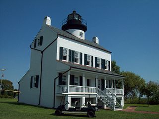
Point Lookout Light is a lighthouse that marks the entrance to the Potomac River at the southernmost tip of Maryland's western shore of the Chesapeake Bay, south of the town of Scotland in Saint Mary's County, Maryland, USA. The lighthouse is located in Point Lookout State Park. It is not open to the public.

Sand Hills was an active lighthouse on the shore of Lake Superior is on private property and is currently closed to the public. It is located in Ahmeek in Keweenaw County in the Keweenaw Peninsula, which is the northern part of the Upper Peninsula in Michigan. It was listed in the National Register of Historic Places in 1994.

The Turkey Point Light is a historic lighthouse at the head of the Chesapeake Bay. Although only a 35-foot (11 m) tower, the 100-foot (30 m) height of the bluffs on which it stands makes it the third highest light off the water in the bay. It is also known for the large number of women who served as lightkeeper.

The Cove Point Light is a lighthouse located on the west side of Chesapeake Bay in Calvert County, Maryland.
The Lower Cedar Point Light was a historic lighthouse in the Potomac River near its eponymous point, south of the present Governor Harry W. Nice Memorial Bridge, which carries U.S. Route 301 between Maryland and Virginia. It has been replaced by a skeleton tower.

Drum Point Light Station also known as Drum Point Lighthouse is one of four surviving Chesapeake Bay screw-pile lighthouses. Originally located off Drum Point at the mouth of the Patuxent River, it is now an exhibit at the Calvert Marine Museum.

Hooper Strait Light is one of four surviving Chesapeake Bay screw-pile lighthouses in the U.S. state of Maryland. Originally located in Hooper Strait, between Hooper and Bloodsworth Islands in Dorchester County and at the entrance to Tangier Sound, it is now an exhibit at the Chesapeake Bay Maritime Museum in St. Michaels, Maryland.

The Cedar Point Light was the last house-type lighthouse built in the Chesapeake Bay. An early victim of shoreline erosion, the cupola and gables are preserved at museums.

Saugerties Light, known also as the Saugerties Lighthouse, is a lighthouse on the Hudson River north of Saugerties, New York.
St. Inigoes, sometimes called St. Inigoes Shores, is a small, rural, unincorporated farming, fishing and crabbing community at the southern end of St. Mary's County in the U.S. state of Maryland that is undergoing a transition to small residential subdevelopment plots. Its western side is bordered by a number of coves and creeks that are connected to the St. Marys River, a brackish tidal tributary, near where it feeds into the mouth of the Potomac River and close to its entry point into the Chesapeake Bay.


