
Colonial Peak is a mountain in the North Cascades of Washington, United States. It rises steeply from the southwest bank of Thunder Arm of Diablo Lake, one of the artificial reservoirs on the Skagit River. It is part of a group of peaks that form the northern end of a chain running south through prized climbing destinations such as Eldorado Peak, Forbidden Peak, and Goode Mountain. Colonial Peak takes its name from the Colonial mining claim on its slopes.

Little Jack is a 6,745-foot-elevation mountain summit in the North Cascades Range of Washington, United States. It is located within the Pasayten Wilderness. It is situated one mile south of its namesake Jack Mountain, west of Crater Mountain, and east of Ross Lake. Like many North Cascade peaks, Little Jack is more notable for its large, steep rise above local terrain than for its absolute elevation. In the early 1900s, the Forest Service built the Little Jack Trail for the purpose of grazing pack animals on the meadows of Little Jack Mountain. The name "Jack" honors Jack Rowley, a gold prospector in the area during the late 1800s, who was credited with finding gold at Ruby Creek.

Graybeard Peak is a 7,965-foot (2,428-metre) mountain summit located in Skagit County, Washington.

Cutthroat Peak is an 8,050-foot-elevation (2,450-meter) granitic mountain located on the boundary of Chelan County and Skagit County, in Washington state. The mountain is part of the Okanagan Range which is a subset of the Cascade Range, and is situated within the Okanogan-Wenatchee National Forest. Cutthroat Peak is about two miles west of Washington Pass and one mile east of Rainy Pass. It's a prominent landmark along the North Cascades Highway with an accessible climbing route. There is also a Cutthroat Lake, Cutthroat Creek, and Cutthroat Pass on its north and east aspects. This geographical feature's name was officially adopted in 1988 by the United States Board on Geographic Names. Molar Tooth is a granite pillar half a mile north on the ridge extending to Cutthroat Pass.

Ruby Mountain is a prominent 7,412-foot (2,259-metre) mountain summit located in the North Cascades Range of Washington state. It is situated in Ross Lake National Recreation Area which is part of the North Cascades National Park Complex. The Diablo Lake Overlook along the North Cascades Highway is at the foot of the mountain. The nearest higher peak is Colonial Peak, 4.2 miles (6.8 km) to the southwest. Precipitation runoff on the east side of the mountain drains into Ross Lake via Ruby Creek, whereas the west side of the mountain drains into Diablo Lake via Thunder Creek. Topographic relief is significant as the summit rises 6,200 feet above Diablo Lake in approximately two miles.

Fisher Peak is an 8,040-foot-elevation mountain summit located in the North Cascades of Washington state. It is situated on the borders of the Stephen Mather Wilderness and North Cascades National Park, midway between Black Peak and Easy Pass, and adjacent to Repulse Peak. Precipitation runoff from Fisher Peak drains into tributaries of the Skagit River.

Paul Bunyans Stump is a 7,480+ ft mountain summit in the North Cascades Range of Washington, United States. It is located within North Cascades National Park. It rises steeply from Diablo Lake, one of the reservoirs on the Skagit River. It is part of a group of peaks that form the northern end of a chain running south through climbing destinations such as Colonial Peak and Snowfield Peak. The nearest peak to Paul Bunyans Stump is Pinnacle Peak, 0.37 mi (0.60 km) to the north, and the nearest higher peak is Neve Peak, 0.9 mi (1.4 km) to the southeast. Like many North Cascade peaks, Paul Bunyans Stump is more notable for its large, steep rise above local terrain than for its absolute elevation. Precipitation runoff from the mountain drains into Diablo Lake and Skagit River.
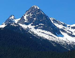
Pyramid Peak is a 7,189-foot (2,191-metre) mountain summit in the North Cascades Range of Washington, United States. It is located within North Cascades National Park. It rises steeply from Diablo Lake, one of the reservoirs on the Skagit River. It is part of a group of peaks that form the northern end of a chain running south through climbing destinations such as Colonial Peak, Paul Bunyans Stump, and Snowfield Peak. Like many North Cascade peaks, Pyramid Peak is more notable for its large, steep rise above local terrain than for its absolute elevation. Precipitation runoff from the mountain drains into Diablo Lake and Skagit River.

The Triplets is a 7,240+ ft summit located in Skagit County of Washington state. This breccia triple pinnacle is part of the North Cascades Range. The Triplets is situated above Cascade Pass on the shared border of North Cascades National Park and Glacier Peak Wilderness. The nearest higher neighbor is Cascade Peak, 0.35 miles (0.56 km) to the west-northwest. Surface runoff from the mountain drains into the Cascade River.

McKay Ridge is a 7,000+ ft ridge located in Whatcom County in Washington state. It is part of the Okanogan Range which is a sub-range of the North Cascades. It's situated north of the North Cascades Highway on land administered by the Okanogan–Wenatchee National Forest. The nearest higher peak is Majestic Mountain, 1.6 miles (2.6 km) to the northeast. Precipitation runoff from the ridge drains into Ross Lake via tributaries of the Skagit River.

Crooked Bum is a 6,937-foot-elevation mountain summit on the crest of the North Cascades in the U.S. state of Washington. It is located in the Okanogan–Wenatchee National Forest on the shared border of Skagit County and Chelan County. It is situated immediately west of Rainy Pass and two miles east of Corteo Peak. The scenic and popular Maple Pass Trail traverses the south slope of the peak while staying above Lake Ann. Precipitation runoff from the north slope of Crooked Bum drains into Granite Creek which is a tributary of the Skagit River, whereas the south side drains into Bridge Creek which is a tributary of the Chelan River.

Pierce Mountain is a 4,973+ ft summit in the North Cascades Range of Washington, United States. It is located within North Cascades National Park and Stephen Mather Wilderness. It is situated above Ross Dam, at the eastern culmination of Sourdough Mountain. Like many North Cascade peaks, Pierce Mountain is more notable for its large, steep rise above local terrain than for its absolute elevation. Precipitation runoff from the mountain drains into the Skagit River via Pierce Creek and Ross Lake.

Red Mountain is a 7,662 feet (2,335 m) summit in the North Cascades Range of Washington, United States. It is located in Skagit County and within North Cascades National Park and the Stephen Mather Wilderness. It is situated on a smooth ridge of brick-red color at the western culmination of Ragged Ridge.

Round Mountain is a 5,320+ ft mountain summit at the western edge of the North Cascades, in Skagit County of Washington state. It is located nine miles northwest of Darrington, Washington and is situated on land administered by the Mount Baker-Snoqualmie National Forest. Round Mountain is remarkable for its 4,780 feet of prominence which ranks as the most in Skagit County, and eighth most of all the mountains in Washington state. The nearest higher peak is Whitehorse Mountain, 7.85 miles (12.63 km) to the south-southeast. Precipitation runoff from Round Mountain drains into tributaries of the Stillaguamish River.

Mount Misch is a remote 7,435 ft mountain summit in the North Cascades, in Skagit County of Washington state. It is the highest point of the Buckindy Range, or Buckindy Ridge. It is located 19 miles east-northeast of Darrington, Washington, and 15 miles north-northwest of Glacier Peak which is one of the Cascade stratovolcanoes. It is situated in the Glacier Peak Wilderness on land administered by the Mount Baker-Snoqualmie National Forest. Mount Misch was named by mountaineer and author Fred Beckey for his friend Peter Misch (1909-1987), University of Washington geology professor and mountaineer, who was renowned for his study of the North Cascades. Precipitation runoff from Mount Misch and the unnamed Goat Creek glacier on its east slope drains into tributaries of the Suiattle River and ultimately the Skagit River.

Snowking Mountain is a 7,433-foot (2,266-metre) summit located in Skagit County of Washington state. Situated within the Glacier Peak Wilderness, Snowking Mountain is positioned west of the crest of the North Cascades Range, approximately 18 miles northeast of the town of Darrington. It is set within the Glacier Peak Wilderness, on land managed by Mount Baker–Snoqualmie National Forest. Snowking has two subsidiary peaks, West Peak (7425 ft), and Middle Peak (7400 ft). A broad unnamed glacier known colloquially as Snowking Glacier rests on the north face. Downslope of that glacier are Snowking Lake, Found Lake, and Cyclone Lake. Mount Tommy Thompson is three miles to the northwest, and the nearest higher neighbor is Mount Misch, 5.75 miles (9.25 km) to the southeast. Precipitation runoff from Snowking Mountain drains into tributaries of the Skagit River.

The Chopping Block is a 6,819-foot (2,078-metre) mountain summit located in the Picket Range within North Cascades National Park in the state of Washington. The mountain is officially named Pinnacle Peak on maps, but hardly anyone calls it by that name. The nearest higher peak is Mount Degenhardt, 0.6 mi (0.97 km) to the northeast. The Chopping Block can be seen from the North Cascades National Park Newhalem visitor center, weather permitting. Precipitation runoff from the peak drains into Goodell Creek, a tributary of the Skagit River.

Pinnacle Mountain is an 8,400+ ft granitic multi-peak massif located in the Chelan Mountains, in Chelan County of Washington state. The mountain is situated in Glacier Peak Wilderness of the North Cascades, on land managed by Wenatchee National Forest. Fred Beckey's Cascade Alpine Guide has the elevation of the highest pinnacle as 8,402 feet. Pinnacle Mountain ranks as the fourth-highest peak in the Chelan Mountains, and 75th-highest summit in Washington state. Its nearest higher neighbor is Saska Peak, 1.9 mi (3.1 km) to the southeast, and Emerald Peak is positioned 2.25 mi (3.62 km) to the east-southeast. Precipitation runoff from the peak drains into the Entiat River and Chelan River drainage basins.

Skagit Peak is a 6,824-foot (2,080-metre) mountain summit located in the North Cascades, in Whatcom County of Washington state. It is situated on the western side of the Cascade crest, at the western edge of the Pasayten Wilderness, on land managed by the Okanogan–Wenatchee National Forest. Skagit Peak is part of the Hozameen Range, a subset of the North Cascades which also includes Hozomeen Mountain to the north, and Jack Mountain to the south. Precipitation runoff from this mountain drains into the Skagit River via Three Fools Creek and Ross Lake.

Lookout Mountain is a 5,699-foot (1,737 m)-elevation summit in the North Cascades, in Skagit County of Washington state. It is located 5 miles (8.0 km) east-northeast of the town of Marblemount,and set on land administered by the Mount Baker-Snoqualmie National Forest. The nearest higher neighbor is Teebone Ridge, 2 miles (3.2 km) to the east-northeast. At the top of Lookout Mountain is a historic US Forest Service lookout station that was built in 1962, which replaced a 1929 structure. Views from the top include Sauk Mountain to the west, with Eldorado Peak and the Picket Range in North Cascades National Park to the east and north respectively. The peak is just one mile outside the park boundary. Access is via a 4.7-mile (7.6 km) trail which gains over 4,400 feet (1,300 m) of elevation. Precipitation runoff from Lookout Mountain drains into tributaries of the Skagit River.


