Pir Panjal Pass

Last updated

Pir Panjal Pass
Peer Ki Gali
Peer Ki Gali Mughal Road Poonch Srinagar.jpg
Pir Panjal Pass
Elevation 3,485 m (11,434 ft)
Traversed by Mughal Road
Location Jammu & Kashmir, India
Range Pir Panjal Range
Coordinates 33°37′48″N74°31′12″E / 33.629931°N 74.519968°E / 33.629931; 74.519968
India Jammu and Kashmir UT adm relief map.svg
Red pog.svg
Location in Jammu and Kashmir, India

The Pir Panjal Pass, also called Peer Ki Gali (or Peer Gali), [1] is a mountain pass and a tourist destination located in the Pir Panjal Range in Jammu and Kashmir, India. It connects the Kashmir Valley to the Rajouri and Poonch districts of Jammu via the Mughal Road. It is the highest point on the Mughal road at 3,490 m (11,450 ft) and lies to the southwest of the Kashmir valley. [2] [3]

Contents

Shrine of Shaikh Ahmed Karim RA PIR PANJAL RANGE.jpg
Shrine of Shaikh Ahmed Karim RA

Name

The Pir Panjal Pass appears in Srivara's Rajatarangini as Panchaladeva (IAST: Pāñcāladeva), meaning the deity of Panchala. Panchala is a kingdom mentioned in the Mahabharata in the northwest Uttar Pradesh. Other traditions place the Mahabharata regions in western Punjab and southern Kashmir. Scholar Dineshchandra Sircar has analysed the geography described in the Shakti‐sangama Tantra, where this is indeed the case. [4]

Scholar M. A. Stein states that the high mountain passes were always regarded as deities or were associated with deities. These customs continued after the region was Islamised by substituting the concept of Pir, Muslim saint, for deity. [5]

The Pir Panjal Pass name is tied to the entire mountain range (Pir Panjal Range). [6] In recent times, the term "Panjal" has become restricted to the mountain range, and the pass came to be called simply Peer Ki Gali (the Pir's pass). [7] It is associated with the saint Mir Sayyid Ali Hamadani as well as another saint Sheikh Ahmed Karim. [8]

Description

The Pir Panjal Pass can be taken to travel between its western entrance, which goes by the name Peer Ki Gali, and a historical way station called Aliabad Sarai at its eastern end. A stream referred to as Pir Panjal stream runs through the valley, flowing east, which becomes the Rambi Ara River in the Shopian district. Scholar Mohibbul Hassan states that the old route through the pass kept to the southern side of the stream, but the Moghuls switched it to the northern side because a steep cliff called Hastivanj to the south was difficult to cross. [9] The modern "Mughal Road" constructed between 2005 and 2009 is close to the route used by the Mughals, though it is not identical to it.

To the west of Peer Ki Gali, cliffs descend steeply into a valley, which carries another mountain stream that joins the Poonch River flowing from the north. A hill village called Bahramgala (original name: Bhairavgala) marks the end of the valley. [10] The Sikh sources name the pass itself as Bahramgala pass, in effect marking Bahramgala as is western end. [11]

The modern Mughal Road avoids the steep descent by following the hill sides to the north. It ends at a town called Bufliaz about 10 km to the west of Bahramgala. From there the National Highway 144A connects to Poonch to the northwest and Rajouri to the south.

At Peer Ki Gali, the temperature often drops as low as -7 °C or -9 °C in winter. [12] It is the highest point on Mughal Road. Peer Ki Gali is 40 km away from Shopian, 80 km from Poonch. [13] [14]

History

Historian Mohibbul Hasan states that the Pir Panjal Pass was one of the main passes into the Kashmir Valley and exercised a great influence on its history. [15] A route linking Hirapur (modern Hirpora) in the Kashmir Valley with Rajauri via the pass is known to have been used from ancient times. During the period of the sultans it seems to have been extended up to Bhimber. [16]

After conquering the Kashmir Valley, the emperor Akbar strengthened the route into an 'Imperial Road' stretching from Lahore to Kashmir. [9] In modern times, the route has been referred to as the 'Mughal Road'. [17]

The Sikh emperor, Maharaja Ranjit Singh, launched an invasion of the Durrani-controlled Kashmir Valley in 1814, partly via the Pir Panjal Pass. He divided the forces into two parts, one attacking via the Pir Panjal Pass under the command of Dewan Ram Dayal and the other led by himself via the Tosa Maidan. Ram Dayal forced through the Pir Panjal pass, reached Baramulla and fortified himself. Ranjit Singh could not break through the Durrani defences at Tosa Madian, and was forced to retreat. [18] In a second invasion in 1819, all the forces were sent via the Tosa Maidan, and conquered the Durrani forces. [19]

Aliabad Sarai

Aliabad Sarai way station seen from behind from the current Mughal Road Aliabad Sarai Mughal Road.jpg
Aliabad Sarai way station seen from behind from the current Mughal Road

The Aliabad Sarai is a rest house in the Pir Panjal Pass, said to have been constructed by the Emperor Jahangir towards the end of the 16th century. It was one of the 14 halting stations constructed between Lahore and Srinagar along the Moghal Road. An Iranian engineer called Ali Mardan Khan was in charge of the construction, aided by the local chieftains. The safe keeping of the heritage building has been neglected by the government, and it has been used in recent times by local shepherds as a shed for cattle. [20] [21]

The original Moghal Road passed in front of the Aliabad Sarai rest house. The current one runs behind it, at a higher elevation.

Pirs

Shrine representing Sheikh Ahmed Karim's meditating place Astanpkg.png
Shrine representing Sheikh Ahmed Karim's meditating place

The local tradition associates Saint Mir Sayyid Ali Hamadani [22] with the Peer Ki Gali. Written records note a Pir called Sheikh Ahmed Karim lived and meditated in the Peer Ki Gali during the time of emperor Jahangir. He converted to Islam from Hinduism, regarded the Peer Ki Gali as a place of God and insisted all the passersby treat it with reverence. The records also state that emperor Jahangir disregarded his commandments, but Shahjahan and Aurangzeb followed them. [13]

A shrine stands in the Peer Ki Gali to mark the Pir's meditating place, inside which some believe is a stone with his hand print. [13]

Related Research Articles

<span class="mw-page-title-main">History of Kashmir</span>

The history of Kashmir is intertwined with the history of the broader Indian subcontinent in South Asia with influences from the surrounding regions of Central and East Asia. Historically, Kashmir referred to only the Kashmir Valley of the western Himalayas. Today, it denotes a larger area that includes the Indian-administered union territories of Jammu and Kashmir and Ladakh, the Pakistan-administered territories of Azad Kashmir and Gilgit-Baltistan, and the Chinese-administered regions of Aksai Chin and the Trans-Karakoram Tract.

<i>Rajatarangini</i> Book by Kalhana

Rājataraṅgiṇī is a metrical legendary and historical chronicle of the north-western part of India, particularly the kings of Kashmir. It was written in Sanskrit by Kashmiri historian Kalhana in the 12th century CE. The work consists of 7826 verses, which are divided between eight books called tarangas ("waves").

<span class="mw-page-title-main">Pir Panjal Range</span> Mountain range of the Lower Himalayas

The Pir Panjal Range is a chain of mountains in the Lower Himalayan region located in the Western Himalayas of northern Indian subcontinent. It runs southeast to northwest between the Beas and Neelam/Kishanganga rivers, in the Indian territories of Himachal Pradesh and Jammu and Kashmir, with its northwestern end extending into Pakistan. The Himalayas show a gradual elevation towards the Dhauladhar and Pir Panjal ranges. Pir Panjal is the largest range of the Lesser Himalayas. Near the bank of the Sutlej River, it dissociates itself from the Himalayas and forms a divide between the Beas and Ravi rivers on one side and the Chenab on the other. Further west, the Pir Panjal range separates the Kashmir Valley from the hills of Jammu region.

<span class="mw-page-title-main">Rajouri district</span> District of Jammu and Kashmir administered by India.

Rajouri or Rajpur is a district in the Jammu division of Indian-administered Jammu and Kashmir in the disputed Kashmir region. The Line of Control lies to its west, Poonch to its north, the Reasi district to the east and the Jammu district to its south. Rajouri is famous for its "Kalari". Representing an ancient principality, Rajouri was a joint district, along with Reasi, at the time of princely state's accession to India in 1947. The two tehsils were separated and Rajouri was merged with the Poonch district. Rajouri again became a separate district in 1968. The Rajouri district comprises 13 tehsils (boroughs). The land is mostly fertile and mountainous. Maize, wheat and rice are the main crops of the area and the main source of the irrigation is the river Tawi that originates from the mountains of Pir Panjal.

<span class="mw-page-title-main">Zain-ul-Abidin</span> Sultan of the Kashmir Sultanate

Shah Rukh Shahi Khan, popularly known as Ghiyas-ud-Din Zainu'l-Abidin or simply Zainu'l-Abidin, was the ninth and eleventh Sultan of Kashmir, who reigned first from 1418 to 1419 and then from 1420 to 1470. He was famously called Budshah by his subjects.

<span class="mw-page-title-main">Banihal</span> Town in Jammu and Kashmir, India

Banihal local pronunciation [banhal] is a town and a notified area committee, near Ramban town in Ramban district in the Indian union territory of Jammu and Kashmir. It is a rural and hilly area with Kamirwah being one of the most prominent hills. It is located about 35 km (22 mi) away from Qazigund of Anantnag district on NH 44. However, the distance between Banihal and Qazigund is only 18 km by train on the new railway line which is much shorter than the road. The most common language spoken in the region is Kashmiri; Urdu, Hindi, Gujjari, Pahari and English being other familiar languages. Banihal forms the main gateway to the valley of Kashmir. Some famous visiting places in banihal are Neel top and Mahu valley.

<span class="mw-page-title-main">Shopian</span> Town in Jammu and Kashmir, India

Shopian or Shupiyan, known as Shupyan in Kashmiri, is an administrative division of the Shopian district, located in southern part of Kashmir Valley, of Jammu and Kashmir, India. Shopian is called the ''Apple town of Kashmir'' as majority of the population engages in apple growing practices which also provides employment to more than 60% of the population. It is 2nd richest district in Kashmir region after Srinagar.

<span class="mw-page-title-main">Didda</span> Ruler of Kashmir from 980–1003

Didda, also known as The Catherine of Kashmir, was the ruler of Kashmir from 980 CE to 1003 CE. She first acted as regent for her son and various grandsons from 958 CE to 980 CE, and from 980 CE as sole ruler and monarch. Most knowledge relating to her is obtained from the Rajatarangini, a work written by Kalhana in the twelfth century.

<span class="mw-page-title-main">Poonch (town)</span> Town in Jammu & Kashmir, India

Poonch, is a town and the administrative headquarters of the Poonch district, of the Indian-administered union territory of Jammu and Kashmir, which is part of the larger disputed territory of Kashmir. It is located near the Line of Control – the de facto border in the disputed region. Poonch shares a de facto border with the Poonch district of the Pakistan-administered, self-governing territory of Azad Kashmir.

<span class="mw-page-title-main">Mughal Road</span> Road in Jammu and Kashmir, India

Mughal Road is the road between Bufliaz, a town in the Poonch district, to the Shopian district, in the union territory of Jammu and Kashmir, India. The 84-kilometre road traces a historic route used in the Mughal period over the Pir Panjal Pass, at an altitude of 3,500 m (11,500 ft), higher than the Banihal pass at 2,832 m (9,291 ft).

The Battle of Shopian took place on 5 July 1819 between an expeditionary force from the Sikh Empire and Jabbar Khan, the governor of the Kashmir Valley province of the Durrani Empire. It was the decisive battle during the Sikh expedition into Kashmir in 1819.

<span class="mw-page-title-main">Poonch River</span> River in India and Pakistan

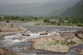
The Poonch River is a tributary of the Jhelum River that flows through Jammu and Kashmir in India, and Jammu and Kashmir in Pakistan.

Surankote is a town in the Surankote Tehsil of the Poonch district of the Indian union territory of Jammu and Kashmir. It occupies the Surankote valley, located between the Pir Panjal and ranges within the Himalayas. It receives snowfall in winters. It is famous for the existence of lakes on the Pir Panjal range which are not still connected with the outside world. Although some people visit these lakes by foot for recreation and refreshment.

<span class="mw-page-title-main">Hirpora Wildlife Sanctuary</span> Wildlife Sanctuary in Jammu and Kashmir

Hirpora Wildlife Sanctuary or Heerpora Wildlife Sanctuary is located, Hirpora in Shopian district of Jammu and Kashmir. It lies 12 km from Shopian town, 70 km (43 mi) south of Srinagar. It spreads over an area of 341 km2 (132 sq mi). It is bounded to the north by Lake Gumsar, northeast by Hirpora village, east by Rupri, south by Saransar and to the west by the Pir Panjal pass. The slopes are gentle to moderately steep on the eastern aspect and very steep with many cliffs on the higher northern and western aspect. The southern and southeastern portions are moderately steep. Heerpora wildlife sanctuary is one of the beautiful wildlife sanctuary in Jammu and Kashmir

<span class="mw-page-title-main">Tosa Maidan</span> Meadow in Jammu & Kashmir, India

Tosa Maidan is a tourist destination and a hill station in the khag area of the Budgam district in the Kashmir Valley of the Indian union territory of Jammu and Kashmir. The name also marks the historic Tosa Maidan route into the Kashmir Valley from the Poonch Valley. In fact, the original name of Tosa Maidan appears to have been "Tosa Marg". Mahmud of Ghazni and the Sikh monarch Ranjit Singh attempted to invade the Kashmir Valley via this route.

<span class="mw-page-title-main">Khag, Jammu and Kashmir</span> Tehsil in Jammu and Kashmir, India

Khag is a tehsil in and block in the Beerwah sub-district of the Budgam district in the Indian union territory of Jammu and Kashmir. It is 8.8 km (5.5 mi) away from sub-district headquarter Beerwah and 35 km (22 mi) away from Srinagar, the summer capital of Jammu and Kashmir.

<span class="mw-page-title-main">Noori Chamb</span> Waterfall in Jammu and Kashmir, India

Noori Chamb is a waterfall in the headwaters of the Poonch River in Poonch district of Jammu and Kashmir in India. It is named after the Mughal queen Nur Jahan.

The Chak or Chaq dynasty was a Kashmiri dynasty of Dardic origin that ruled over the Kashmir sultanate in medieval Kashmir after the Shah Mir dynasty. The dynasty rose to power in 1561 in Srinagar after the death of the Turco-Mongol military general, Mirza Haidar Dughlat when Ghazi Shah assumed the throne by dethroning Habib Shah, the last Shah Mir Sultan. The dynasty ended in 1589 when Yakub Shah surrendered to Akbar.

<span class="mw-page-title-main">Pir Panjal Region</span> Region in Jammu and Kashmir, India

The Pir Panjal Region is a region located in the southwestern part of the Pir Panjal Range in the Jammu Division of the Indian-administered union territory of Jammu and Kashmir. This name particularly refers to the districts of Poonch and Rajouri.

References

  1. Bloeria, Sudhir S. (2000), Pakistan's Insurgency Vs India's Security: Tackling Militancy in Kashmir, Manas Publications, p. 18, ISBN   978-81-7049-116-3 : "The Pir Panjal Pass also known as Pir Ki Gali, is the point over which the famous Mughal Route crosses the Range."
  2. Kapadia, Harish (1999), Across Peaks & Passes in Ladakh, Zanskar & East Karakoram, Indus Publishing, p. 23, ISBN   978-81-7387-100-9
  3. "South Kashmir: Fresh snowfall at Pir ki Gali closes Mughal road". Kashmir Reader. 1 November 2018. Archived from the original on 23 April 2019. Retrieved 14 November 2018.
  4. Sircar, Dineschandra (1971), Studies in the Geography of Ancient and Medieval India, Motilal Banarsidass, pp. 204–205, ISBN   978-81-208-0690-0
  5. Stein, Kalhana's Rajatarangini, Volume 2 (1900), note 46, pp. 397–398.
  6. Kohli, M. S. (2002). Mountains of India : tourism, adventure and pilgrimage. New Delhi: Indus. ISBN   81-7387-135-3. OCLC   53249912.
  7. "Snowfall hampers efforts to restore Mughal Road". India Today. 24 December 2017.
  8. taffutul arifin manuscript
  9. 1 2 Hasan, Kashmir under the Sultans (1959), p. 24.
  10. Stein, Kalhana's Rajatarangini, Volume 2 (1900), p. 398.
  11. Gupta, The Sikh Lion of Lahore (1991), p. 125.
  12. "43 rescued from Zojila, Pir Ki Gali after 3 days". Daily Excelsior. 6 November 2018.
  13. 1 2 3 Irfan, Shams (15 July 2014). "History and Mystery of Peer ki Gali". Kashmir Life. Archived from the original on 24 February 2020. Retrieved 19 October 2018.
  14. "Peer ki Gali". J&K Tourism Development Corporation. Retrieved 21 July 2019.
  15. Hasan, Kashmir under the Sultans (1959), p. 22.
  16. Hasan, Kashmir under the Sultans (1959), pp. 23–24.
  17. Now, Mughal Road To Connect J&K, The Times of India, 14 July 2005.
  18. Gupta, The Sikh Lion of Lahore 1991, pp. 125–127.
  19. Gupta, The Sikh Lion of Lahore 1991, pp. 128–129.
  20. Tazeem Akhter, A Peek into the Aliabad Sarai, Kashmir Times, 14 October 2012.
  21. "District Census Handbook – Shupiyan" (PDF). censusindia.gov.in. Census of India. 2011.
  22. tafatul arfin manucript

Bibliography