Pisco, Peru

Last updated
Pisco
City
Pisco city.JPG
Aeropuerto Pisco 2015.JPG
Municipalidad de Pisco (7137052535).jpg
Ministro de Defensa Inaugura Obras en Pisco (13117255145).jpg
Pisco - Plaza de Armas - panoramio.jpg
San Clemente Cathedral of Pisco (2002).jpg
Plaza moderna de pisco.jpg
Bandera de Pisco.png
Escudo de Pisco.png
Peru location map.svg
Red pog.svg
Pisco
Coordinates: 13°43′S76°12′W / 13.717°S 76.200°W / -13.717; -76.200
CountryFlag of Peru.svg  Peru
Region Ica
Province Pisco
District Pisco
Government
  MayorJuan Mendoza Uribe
(2019-2022)
Area
  Total3,978.19 km2 (1,535.99 sq mi)
Elevation
9 m (30 ft)
Population
  Estimate 
(2015) [1]
104,656
Demonym Pisquena(o)
Time zone UTC-5 (PET)
Website Official Website

Pisco (Quechua : Pisqu) is a city located in the Department of Ica of Peru, the capital of the Pisco Province. The city is around 9 metres (28 feet) above sea level. Pisco was founded in 1640, [2] close to the indigenous emplacement of the same name. Pisco originally prospered because of its nearby vineyards and became noted for its grape brandy or pisco [3] which was exported from its port. Pisco has an estimated population of 104,656 (est. 2015). [4]

Contents

History

The city was highly populated until 1685, when it was pillaged by English pirates. The city suffered again in 1687 because of an earthquake. Vines are abundant, despite the sandy and infertile terrain; they grow in many places because of the moisture from inside the earth and provide Lima with its wines and grape concentrates that run along the various mountain provinces extending to Panama and Guayaquil. [5]

Pisco was attacked by the pirates Clerck and David; in addition, in 1687 it was destroyed by an earthquake, which caused a tsunami to follow, destroying the city further. Viceroy Melchor Antonio Portocarrero Lazo de la Vega then moved it to its current location, reestablishing it in 1689 as "Villa de Nuestra Señora de la Concordia de Pisco".

Mid 16th Century: Pisco is Born

The town of Santa Maria Magdalena, which was founded in 1572, had a port named Pisco, after the name of the valley in which it was located. This port became an important route for distribution of the liqueur throughout Peru. Demand for the product grew as sailors from around the world who called into the Port of Pisco created an important international trade link and further demand for the product. Over time, the town of Santa Maria Magdalena became simply known as 'Pisco' with the same name adopted for the grape liqueur produced from the area. In a few decades, Pisco was distributed along the entire coast of Peru and Chile, as well as being exported through ports in the Pacific and Europe.

Independence of Peru

In 1820, the Liberating Expedition [6] [7] arrived in Pisco under the command of José de San Martín [8] and Bernardo O'Higgins Riquelme, disembarking in the Bay of Paracas, where the first flag and the first national emblem of Peru were created. In 1832, the Peruvian Congress ordered by law that the city of Lima would receive the title of "Villa y Puerto de la Independencia", extending this qualification to both the town and the riverbank population. In 1868 the "town of Pisco" was designated capital of the new province of Chincha, and in 1898 it was elevated to the rank of "city". In 1947, the historian pisqueño Mamerto Castillo Negrón said that Pisco had received two additions in its history that granted it honors worthy of merit, the first being "Villa and Puerto de la Independencia" and second, its recognition as a provincial capital.

2007 earthquake

Pisco after the earthquake Pisco after the earthquake.jpg
Pisco after the earthquake

The city was very near the center of the devastating 8.0-magnitude earthquake which struck south central Peru on Wednesday 15 August 2007. Media officials reported that 80% of the city was destroyed, including the central San Clemente Cathedral of Pisco, located in Plaza de Armas in which mass was taking place at the time of the earthquake. [9] The resulting dead account for a reported 30 percent of the total fatalities caused by the earthquake. [10] Several hundred more were killed throughout the city [11] Several years on, the city is still recovering from the damage done during the earthquake. [12]

Geography

Climate

The city of Pisco experiences hot arid climate, with warm temperatures and extremely low rainfall prevailing all year-round. According to the Köppen Climate Classification system, Pisco has a desert climate, abbreviated BWh on climate maps. [13] The average maximum temperature in the city is 23.7 °C (74.7 °F), ranging from a February peak of 27.7 °C (81.9 °F) to a July low of 20.2 °C (68.4 °F). The average minimum temperature in the city is 15.8 °C (60.4 °F), fluctuating from 19.5 °C (67.1 °F) to 12.9 °C (55.2 °F) in the months of February and August respectively. Rainfall is extremely low; the average annual rainfall total amounts to a mere 1.5 mm (0.1 in).

Climate data for Pisco, Peru (1961–1990, extremes 1942–present)
MonthJanFebMarAprMayJunJulAugSepOctNovDecYear
Record high °C (°F)33.9
(93.0)
33.2
(91.8)
33.5
(92.3)
32.0
(89.6)
30.2
(86.4)
31.0
(87.8)
28.0
(82.4)
28.4
(83.1)
29.2
(84.6)
27.0
(80.6)
28.3
(82.9)
31.2
(88.2)
33.9
(93.0)
Mean daily maximum °C (°F)26.9
(80.4)
27.7
(81.9)
27.3
(81.1)
25.7
(78.3)
23.1
(73.6)
21.2
(70.2)
20.2
(68.4)
20.4
(68.7)
21.0
(69.8)
22.0
(71.6)
23.2
(73.8)
25.2
(77.4)
23.7
(74.7)
Daily mean °C (°F)21.8
(71.2)
22.5
(72.5)
22.3
(72.1)
20.7
(69.3)
18.4
(65.1)
17.0
(62.6)
16.2
(61.2)
16.0
(60.8)
16.4
(61.5)
17.3
(63.1)
18.4
(65.1)
20.3
(68.5)
18.9
(66.0)
Mean daily minimum °C (°F)18.7
(65.7)
19.5
(67.1)
19.0
(66.2)
17.4
(63.3)
15.2
(59.4)
13.8
(56.8)
13.1
(55.6)
12.9
(55.2)
13.3
(55.9)
14.2
(57.6)
15.4
(59.7)
17.1
(62.8)
15.8
(60.4)
Record low °C (°F)10.5
(50.9)
14.3
(57.7)
12.0
(53.6)
10.0
(50.0)
7.0
(44.6)
7.8
(46.0)
7.0
(44.6)
7.2
(45.0)
8.0
(46.4)
7.0
(44.6)
9.5
(49.1)
9.2
(48.6)
7.0
(44.6)
Average rainfall mm (inches)0.2
(0.01)
0.1
(0.00)
0.2
(0.01)
0.0
(0.0)
0.0
(0.0)
0.1
(0.00)
0.1
(0.00)
0.3
(0.01)
0.2
(0.01)
0.2
(0.01)
0.1
(0.00)
0.0
(0.0)
1.5
(0.06)
Average rainy days (≥ 1.0 mm)0.10.10.00.00.00.00.10.00.10.20.00.00.5
Average relative humidity (%)83818182838281838483828282
Source 1: NOAA [14]
Source 2: Meteo Climat (record highs and lows), [15] Deutscher Wetterdienst (mean temperatures 1949–1985, precipitation days 1970–1990 and humidity 1954–1969) [16]

Transport

Pisco is served by the Capitán FAP Renán Elías Olivera Airport (IATA: PIO, ICAO: SPSO), located in Pisco (PIO). [17] This international airport shares facilities with the Peruvian Air Force and is also designated as a back-up airport to the Jorge Chávez International Airport (IATA: LIM, ICAO: SPIM) in Lima, Peru. On September 4, 2012, President Ollanta Humala was present for the beginning of renovations to the airport, [18] which is expected to be operational by 2015 with the ability to receive an anticipated 400,000 passengers a year in 2017.

Tourist attractions

Pisco is a Quechua word meaning "bird". [3] The area is often visited because of the concentration of marine animals and birds at the Paracas National Reserve, or the Peruvian Galápagos. [19] At the reserve there are the Islas Ballestas, a collection of islands which are off limits to people, but boat tours can get close to. The Chincha Islands are also near its coast. Many bird species can be seen in the islands including pelicans, penguins, cormorants, Peruvian boobies, and Inca terns, as well as sea lions, turtles, dolphins, and whales.

Another attraction in the area is El Candelabro, a giant lamp dug in the rough sand in the method used by the creators of the Nazca Lines.

One of the major ancient civilizations in Peru, the Paracas culture, flourished in the area where Pisco sits. Due to its ease of access and its crossroads to the Andes, the Spaniards may have considered making Pisco the capital, before they decided on Lima.

In the city is the Plaza de Armas, where people buy tejas, small sweets made from pecans and assorted dried fruits. Many different building that surround the Plaza are the statue of José de San Martín, the mansion he lived in, and the Municipal Palace. Other building in the city is the heavily baroque Iglesia de la Compañía, begun in 1689, features a superb carved pulpit and gold-leaf altarpiece.

Near the town, just off the road to Ayacucho, lies the large, well-preserved Inca site of Tambo Colorado.

Notable people

International relations

Twin towns – Sister cities

Pisco is twinned with:

Related Research Articles

Pisco is a colorless or yellowish-to-amber colored spirit produced in winemaking regions of Peru and Chile. Made by distilling fermented grape juice into a high-proof spirit, it was developed by 16th-century Spanish settlers as an alternative to orujo, a pomace brandy that was being imported from Spain. It had the advantages of being produced from abundant domestically grown fruit and reducing the volume of alcoholic beverages transported to remote locations.

<span class="mw-page-title-main">Chimbote</span> Place in Ancash, Peru

Chimbote ; Quechua: Chimputi) is the largest city in the Ancash Region of Peru, and the capital of both Santa Province and Chimbote District.

<span class="mw-page-title-main">Nazca</span> Archaeological site and modern city in Peru

Nazca is a city and system of valleys on the southern coast of Peru. The city of Nazca is the largest in the Nazca Province. The name is derived from the Nazca culture, which flourished in the area between 100 BC and AD 800. This culture was responsible for the Nazca Lines and the ceremonial city of Cahuachi. They also constructed additional underground aqueducts, named puquios, in a regional system that still functions today. The first puquios are believed to have been built by the preceding Paracas culture.

<span class="mw-page-title-main">Piura</span> Place in Peru

Piura is a city in northwestern Peru located north of the Sechura Desert on the Piura River. It is the capital of the Piura Region and the Piura Province. Its population was 484,475 as of 2017 and is the 7th most populous city in Peru. The city is located in the central eastern part of the Piura Region, 981 kilometers from the countrys capital, Lima and is near to the border with Ecuador.

<span class="mw-page-title-main">Puno</span> Place in Peru

Puno is a city in southeastern Peru, located on the shore of Lake Titicaca. It is the capital city of the Puno Region and the Puno Province with a population of approximately 140,839. The city was established in 1668 by viceroy Pedro Antonio Fernández de Castro as capital of the province of Paucarcolla with the name San Juan Bautista de Puno. The name was later changed to San Carlos de Puno, in honor of king Charles II of Spain. Puno has several churches dating back from the colonial period; they were built to service the Spanish population and evangelize the Quechua people.

<span class="mw-page-title-main">Department of Ica</span> First-level administrative division on the southwestern coast of Peru

Ica is a department and region of Peru. It borders the Pacific Ocean on the west; the Lima Region on the north; the Huancavelica and Ayacucho regions on the east; and the Arequipa Region on the south. Its capital is the city of Ica.

<span class="mw-page-title-main">Department of Moquegua</span> Departments of Peru

Moquegua is a department and region in southern Peru that extends from the coast to the highlands. Its capital is the city of Moquegua, which is among the main Peruvian cities for its high rates of GDP and national education.

<span class="mw-page-title-main">Ica, Peru</span> Place in Ica, Peru

Ica is a city and the capital of the Department of Ica in southern Peru. While the area was long inhabited by varying cultures of indigenous peoples, the Spanish conquistador Jerónimo Luis de Cabrera claimed its founding in 1563.

<span class="mw-page-title-main">San Vicente de Cañete</span> Place in Lima, Peru

San Vicente de Cañete, commonly known as San Vicente or Cañete, is a city and capital of the Cañete Province, in southern Lima Region. With a population of 85,533.

<span class="mw-page-title-main">Huánuco</span> Place in Peru

Huánuco is a city in central Peru. It had a population of 196,627 as of 2017 and in 2015 it had a population of 175,068. It is the capital of the Huánuco Region and the Huánuco District. It is the seat of the diocese of Huánuco. The metropolitan city of Huanuco is 170,000 hab. It has three districts, Huanuco (head), Amarilis, and Pillco Marca. In this city, the Higueras river meets the Huallaga river, one of the largest rivers in the country.

<span class="mw-page-title-main">Tumbes, Peru</span> Town in Tumbes, Peru

Tumbes is a city in northwestern Peru, on the banks of the Tumbes River. It is the capital of the Tumbes Region, as well as of Tumbes Province and Tumbes District. Located near the border with Ecuador, Tumbes has 111,595 inhabitants as of 2015. It is served by the Cap. FAP Pedro Canga Rodriguez Airport. It is located on the Gulf of Guayaquil along with Zorritos.

<span class="mw-page-title-main">Talara</span> City in Piura, Peru

Talara is a city in the Talara Province of the Piura Region, in northwestern Peru. It is a port city on the Pacific Ocean with a population of 91,444 as of 2017. Its climate is hot and dry. Due to its oil reserves, and ability to produce aviation fuel, Talara hosted a United States air base during World War II. It was also one of two refueling stations for the Pacific Fleet. There were naval guns on the hills, and submarine nets in the harbor. The Ajax, Achilles and Exeter, three British destroyers, were refuelled there on their way around the Horn to catch the Graf Spee in Rio de la Plata. Talara is also home to a large fishing fleet. The city is served by the Cap. FAP Víctor Montes Arias Airport.

<span class="mw-page-title-main">Tarapoto</span> Town in San Martín, Peru

Tarapoto is a commercial hub town in the San Martín Province of the Department of San Martín of northern Peru. It is an hour by plane from Lima, in the high jungle plateau to the east of what is known as the selva baja. Although Moyobamba is the capital of the region, Tarapoto is the region's largest city and is linked to the Upper Amazon and the historic city of Yurimaguas by a relatively well-maintained transandean highway, paved in 2008–9.

<span class="mw-page-title-main">Pisco Province</span> Province in Ica, Peru

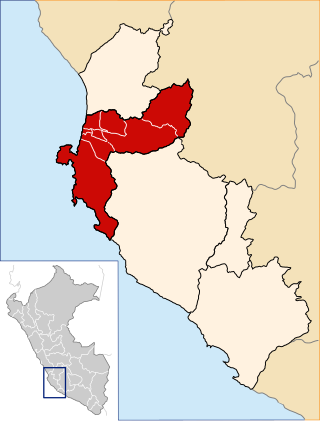
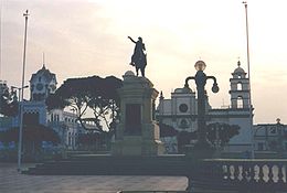
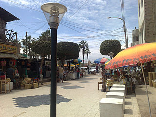
Pisco is a province of the Ica Region in Peru. Its capital is the town of Pisco, where the popular liquor of the same name originated.

<span class="mw-page-title-main">Paracas National Reserve</span>

Paracas National Reserve is a protected area located in the region of Ica, Peru and protects desert and marine ecosystems for their conservation and sustainable use. There are also archaeological remains of the Paracas culture inside the reserve.

<span class="mw-page-title-main">Chincha Alta</span> Town in Ica, Peru

Chincha Alta is a Peruvian city located in the Ica Region. A major port at the mouth of the Chincha River, it is the capital of Chincha Province.

<span class="mw-page-title-main">2007 Peru earthquake</span> 2007 earthquake and tsunami centered off the coast of Ica Department, Peru

The 2007 Peru earthquake, which measured 8.0 on the moment magnitude scale, hit the central coast of Peru on August 15 at 23:40:57 UTC and lasted two minutes. The epicenter was located 150 km (93 mi) south-southeast of Lima at a depth of 39 km (24 mi). At least 595 people died and over 2,290 people were injured.

<span class="mw-page-title-main">Capitán FAP Renán Elías Olivera Airport</span> Airport in Peru

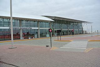
The Capitán FAP Renán Elías Olivera Airport is an airport serving Pisco, an oceanside city in the Ica Region of Peru. It is used by the Peruvian Army, but it can be also used by civil aircraft.

Peruvian wine dates back to the Spanish colonization of the region in the 16th century.

<span class="mw-page-title-main">Ballestas Islands</span>

The Ballestas Islands are a group of small islands near the town of Paracas within the Paracas District of the Pisco Province in the Ica Region, on the south coast of Peru.

References

  1. Perú: Población estimada al 30 de junio y tasa de crecimiento de las ciudades capitales, por departamento, 2011 y 2015. Perú: Estimaciones y proyecciones de población total por sexo de las principales ciudades, 2012-2015 (Report). Instituto Nacional de Estadística e Informática. March 2012. Retrieved 2015-06-03.
  2. Pisco celebrates its 371st anniversary
  3. 1 2 Pisco (Peru) at Encyclopædia Britannica
  4. Peru population estimates at INEI.gob.pe
  5. "History of Pisco". The Pisco People. Retrieved 2019-02-21.
  6. "The Liberation of Peru | History Today". www.historytoday.com. Retrieved 2019-02-21.
  7. Delaney, Robert W. (January 1962). "General Miller and the Confederación Perú-Boliviana". The Americas. 18 (3): 213–242. doi:10.2307/979153. ISSN   0003-1615. JSTOR   979153. S2CID   147014960.
  8. "José de San Martín | Argentine revolutionary". Encyclopedia Britannica. Retrieved 2019-02-21.
  9. Grim quake toll from Peru church at BBC News
  10. Alex K Tang, PE and Jorgen Johansson, ed. (2008). Pisco, Peru Earthquake of August 15, 2007. Reston, VA: ASCE, Technical Council on Lifeline Earthquake Engineering. ISBN   9780784410615. Archived from the original on November 14, 2012.
  11. "Quake Orphan Reflects Peru's Loss, and Anger (Published 2007)". The New York Times .
  12. Pisco Sin Fronteras, an NGO working to help rebuild Pisco
  13. Climate Summary for Pisco, Peru
  14. "Pisco Climate Normals 1961–1990". National Oceanic and Atmospheric Administration . Retrieved April 23, 2015.
  15. "Station Pisco" (in French). Meteo Climat. Retrieved October 19, 2016.
  16. "Klimatafel von Pisco, Prov. Ica / Peru" (PDF). Baseline climate means (1961-1990) from stations all over the world (in German). Deutscher Wetterdienst. Retrieved December 18, 2018.
  17. Capitán FAP Renán Elías Olivera Airport
  18. Peru starts work at Pisco international airport at Peru this Week
  19. Pisco at Trekker.co.il
  20. "Town Twinning Agreements". Municipalidad de Rosario - Buenos Aires 711. Archived from the original on 2015-03-19. Retrieved 2014-10-14.