Pitkas Point, Alaska

Last updated

Pitkas Point
Negeqliim Painga
CDP
AKMap-doton-PitkasPoint.PNG
Location of Pitkas Point, Alaska
Coordinates: 62°2′8″N163°15′39″W / 62.03556°N 163.26083°W / 62.03556; -163.26083
Country United States
State Alaska
Census Area Kusilvak
Government
   State senator Donald Olson (D)
   State rep. Neal Foster (D)
Area
[1]
  Total1.61 sq mi (4.16 km2)
  Land1.61 sq mi (4.16 km2)
  Water0.00 sq mi (0.00 km2)
Population
 (2020)
  Total120
  Density74.72/sq mi (28.84/km2)
Time zone UTC-9 (Alaska (AKST))
  Summer (DST) UTC-8 (AKDT)
Area code 907
FIPS code 02-60860

Pitkas Point (Central Yupik : Negeqliim Painga) is a census-designated place (CDP) in Kusilvak Census Area, Alaska, United States. The population was 109 at the 2010 census, down from 125 in 2000.

Contents

Geography

Pitkas Point is located at 62°2′8″N163°15′39″W / 62.03556°N 163.26083°W / 62.03556; -163.26083 (62.035485, -163.260857). [2]

According to the United States Census Bureau, the CDP has a total area of 1.5 square miles (3.9 km2), all of it land.

Demographics

Historical population
CensusPop.Note
1940 50
1950 8468.0%
1960 28−66.7%
1970 70150.0%
1980 8825.7%
1990 13553.4%
2000 125−7.4%
2010 109−12.8%
2020 12010.1%
U.S. Decennial Census [3]

Pitkas Point first appeared on the 1940 U.S. Census as the unincorporated village of "Pitka's Point". In 1950, it returned as Pitkas Point. It was made a census-designated place (CDP) in 1980.

As of the census [4] of 2000, there were 125 people, 30 households, and 24 families residing in the CDP. The population density was 83.9 inhabitants per square mile (32.4/km2). There were 42 housing units at an average density of 28.2 per square mile (10.9/km2). The racial makeup of the CDP was 6.40% White, 91.20% Native American, and 2.40% from two or more races.

There were 30 households, out of which 56.7% had children under the age of 18 living with them, 56.7% were married couples living together, 13.3% had a female householder with no husband present, and 20.0% were non-families. 20.0% of all households were made up of individuals, and 3.3% had someone living alone who was 65 years of age or older. The average household size was 4.17 and the average family size was 4.92.

In the CDP, the population was spread out, with 46.4% under the age of 18, 8.8% from 18 to 24, 26.4% from 25 to 44, 15.2% from 45 to 64, and 3.2% who were 65 years of age or older. The median age was 22 years. For every 100 females, there were 101.6 males. For every 100 females age 18 and over, there were 109.4 males.

The median income for a household in the CDP was $41,875, and the median income for a family was $46,250. Males had a median income of $26,250 versus $21,250 for females. The per capita income for the CDP was $10,488. There were 40.0% of families and 32.2% of the population living below the poverty line, including 33.3% of under eighteens and 57.1% of those over 64.

Education

Until 2012, the Lower Yukon School District operated Pitkas Point School. In the 2011–12 school year, the school had eight students in pre-K through eighth grade. Due to the low enrollment, the town now runs a bus to St. Mary's for K-12 students. [5]

Related Research Articles

<span class="mw-page-title-main">Moores Mill, Alabama</span> Census-designated place in Alabama, United States

Moores Mill is an unincorporated community and census-designated place (CDP) in Madison County, Alabama, United States, and is included in the Huntsville-Decatur Combined Statistical Area. The population was 6,729 at the 2020 census, up from 5,682 at the 2010 census.

<span class="mw-page-title-main">Kwigillingok, Alaska</span> CDP in Alaska, United States

Kwigillingok is a census-designated place (CDP) in Bethel Census Area, Alaska, United States. The population was 321 at the 2010 census, down from 338 in 2000.

<span class="mw-page-title-main">Chistochina, Alaska</span> CDP in Alaska, United States

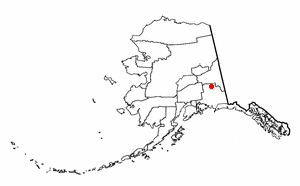
Chistochina is a census-designated place (CDP) in Copper River Census Area, Alaska, United States. At the 2020 census the population was 60, down from 93 in 2010.

<span class="mw-page-title-main">LeChee, Arizona</span> CDP in Coconino County, Arizona

LeChee is a census-designated place (CDP) in Coconino County, Arizona, United States. The population was 1,443 at the 2010 census.

<span class="mw-page-title-main">Shongopovi, Arizona</span> CDP in Navajo County, Arizona

Shongopovi is a census-designated place (CDP) in Navajo County, Arizona, United States. It is located on the Second Mesa, within the Hopi Reservation.

<span class="mw-page-title-main">Lakeview, California</span> Census-designated place in California, United States

Lakeview is a census-designated place (CDP) in Riverside County, California, United States. The population was 2,104 at the 2010 census, up from 1,619 at the 2000 census. The community is named for nearby Mystic Lake.

<span class="mw-page-title-main">West Pensacola, Florida</span> Census-designated place in Florida, United States

West Pensacola is a census-designated place (CDP) in Escambia County, Florida. The population was 21,339 at the 2010 census. It is part of the Pensacola–Ferry Pass–Brent Metropolitan Statistical Area. The CDP area includes the community of Brownsville.

<span class="mw-page-title-main">Bagdad, Florida</span> CDP in Florida, United States

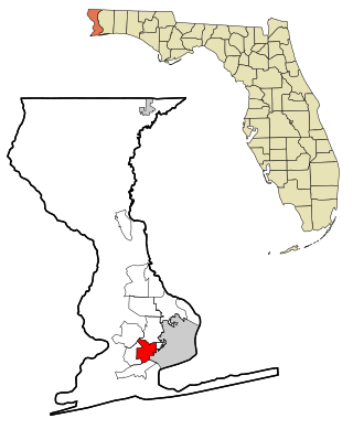
Bagdad is a census-designated place (CDP) in Santa Rosa County, Florida, United States. The population was 1,490 at the 2000 census. It is part of the Pensacola–Ferry Pass–Brent Metropolitan Statistical Area.

<span class="mw-page-title-main">Edgemere, Maryland</span> Census-designated place in Maryland, United States

Edgemere is an unincorporated community and census-designated place in Baltimore County, Maryland, United States. The population was 8,669 at the 2010 census. Founded in 1899 as Edgemere being renamed from previous name "Fitzell". Meeting held at the Fitzell Farm which was situated where the old Rheem plant was located.

<span class="mw-page-title-main">Napoleon, Michigan</span> Census-designated place & unincorporated community in Michigan, United States

Napoleon is an unincorporated community and census-designated place (CDP) in Jackson County in the U.S. state of Michigan. The population of the CDP was 1,258 at the 2010 census. It is located within Napoleon Township.

<span class="mw-page-title-main">Affton, Missouri</span> Census-designated place in Missouri, United States

Affton is a census-designated place (CDP) in south St. Louis County, Missouri, United States, near St. Louis. The population was 20,417 at the 2020 United States Census.

<span class="mw-page-title-main">Hillcrest, Rockland County, New York</span> Census-designated place in New York, United States

Hillcrest is a hamlet incorporated in 1893 and census-designated place, in the town of Ramapo, Rockland County, New York, United States. It is located north of Spring Valley, east of Viola, south of New Square and New Hempstead, and west of New City. The population was 8,164 at the 2020 census.

<span class="mw-page-title-main">Grandview, Hamilton County, Ohio</span> Census-designated place in Ohio, United States

Grandview is a census-designated place (CDP) in Hamilton County, Ohio, United States. The population was 1,312 at the 2020 census.

Renningers is a census-designated place (CDP) in Schuylkill County, Pennsylvania, United States. The population was 380 at the 2000 census.

<span class="mw-page-title-main">Rembert, South Carolina</span> Town in South Carolina, United States

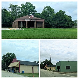
Rembert is a town in Sumter County, South Carolina, United States. The population was 306 at the 2010 census, a decline from 406 in 2000. It is included in the Sumter, South Carolina Metropolitan Statistical Area.

<span class="mw-page-title-main">Ratamosa, Texas</span> Census-designated place in Texas, United States

Ratamosa is a census-designated place (CDP) in Cameron County, Texas, United States. The population was 254 at the 2010 census. It is part of the Brownsville–Harlingen Metropolitan Statistical Area.

<span class="mw-page-title-main">Reid Hope King, Texas</span> Census-designated place in Texas, United States

Reid Hope King is a census-designated place (CDP) in Cameron County, Texas, United States. The population was 786 at the 2010 census. It is part of the Brownsville–Harlingen Metropolitan Statistical Area.

<span class="mw-page-title-main">Tradewinds, Texas</span> CDP in Texas, United States

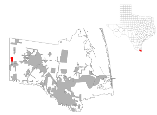
Tradewinds is a census-designated place (CDP) in San Patricio County, Texas, United States. The population was 180 at the 2010 census.

<span class="mw-page-title-main">Crowheart, Wyoming</span> CDP in Wyoming, United States

Crowheart is a census-designated place (CDP) in Fremont County, Wyoming, United States. The population was 120 at the 2020 census. Nearby Crowheart Butte was the site of a battle between the Crow and Shoshone American Indian tribes in 1866. According to legend, following a five-day battle for rights to the hunting grounds in the Wind River Range, Chief Washakie of the Shoshone and Chief Big Robber of the Crow agreed to a duel, with the winner gaining the rights to the Wind River hunting grounds. Chief Washakie eventually prevailed, but he was so impressed with the courage of his opponent, that rather than scalp him, he instead cut out his heart and placed it on the end of his lance.

<span class="mw-page-title-main">Windsor, Wisconsin</span> Village in Wisconsin, United States

Windsor is a village and former town in Dane County, Wisconsin. The population was 8,754 at the time of the 2020 census. The communities of Lake Windsor, Morrisonville, and Token Creek are located within the village. Windsor voted to incorporate as a village on November 3, 2015; prior to its incorporation, it was a town, and a portion of the town was a census-designated place. Windsor is a part of the Census Bureau's Madison metropolitan statistical area.

References

  1. "2020 U.S. Gazetteer Files". United States Census Bureau. Retrieved October 29, 2021.
  2. "US Gazetteer files: 2010, 2000, and 1990". United States Census Bureau. February 12, 2011. Retrieved April 23, 2011.
  3. "U.S. Decennial Census". Census.gov. Retrieved June 6, 2013.
  4. "U.S. Census website". United States Census Bureau . Retrieved January 31, 2008.
  5. "Dwindling students mean four more rural Alaska schools will close". Anchorage Daily News. June 5, 2012. Retrieved November 27, 2019.