Pitve

Last updated

Pitve
Pityeia
Village
Hvar Pitve.jpg
Pitve
Croatia location map.svg
Red pog.svg
Pitve
Location of Pitve within Croatia
Coordinates: 43°09′07″N16°40′08″E / 43.15194°N 16.66889°E / 43.15194; 16.66889
Country Croatia
County Split-Dalmatia County
Municipality Jelsa
Area
[1]
  Total6.6 km2 (2.5 sq mi)
Elevation
168 m (551 ft)
Population
 (2021) [2]
  Total90
  Density14/km2 (35/sq mi)
Time zone UTC+1 (CET)
  Summer (DST) UTC+2 (CEST)
Postal code
21465 Pitve
Area code +385 (0)21
Pitve Pitve.jpg
Pitve

Pitve is a settlement on the island of Hvar, in the district of Jelsa. It lies 168 metres above sea-level on the northern side of the island, in the hills above Jelsa.

Contents

The road from Jelsa and Vrisnik goes through the 1,500 metre long Pitve tunnel to reach Zavala on the south side of the island.

Name

Pitve is derived from Pityeia, which is the oldest-known name for the island. It was mentioned as being one of the Liburnian isles, along with Issa (Vis) and Dysceladus, [3] [4] and is associated with pine woods.

History

Pitve is one of the oldest continuously occupied settlements on the island. It is a village in two parts: the upper, older section known as Gornje Pitve, and a newer, lower part known as Donje Pitve. Gornje Pitve was founded by the Liburnians, an ancient Illyrian tribe who inhabited the island before the arrival of the ancient Greeks in 384 B.C. [5] At that time, the name for the entire island was Pityeia. Donje Pitve dates from the 15th and early 16th century, when there was an influx of people from the mainland escaping the invading Turks.

Between Upper and Lower Pitve lie the old school (today a wine cooperative), the parish church of St James (Sv Jakov), a cemetery, and the former library and economic home that are no longer in use.

The fishing port for Pitve was mentioned in the Hvar Statute of 1331 as Portus de Pitue, and is now known as Jelsa.

Location/geography

Pitve lies at the top of a valley below the cliff called Samotorac at the entrance to the Vratnik pass. [6]

Culture

The patron saint of Pitve is St James (Sv Jakov). On Holy Thursday, Pitve is one of the places that participates in the traditional procession "Za križen", or "Following the Cross".

Sport

Pitve's football club is known as NK Poskok – the Vipers.

Population

Beginning with the census of 1991, the population figures for Pitve reduced as the inhabitants of Zavala were counted as an independent settlement, which contains data for 1857, 1869, 1921 and in 1931.

Population chart 1857-2001 [7]

YearPopulation
1857350
1869446
1880435
1890501
1900569
1910573
1921756
1931579
1948419
1953315
1961264
1971191
1981146
1991112
200181

Notable people from Pitve

Related Research Articles

<span class="mw-page-title-main">Split-Dalmatia County</span> County in southern Croatia

Split-Dalmatia County is a central-southern Dalmatian county in Croatia. The administrative center is Split. The population of the county is 455,242 (2011). The land area is 14.106,40 km2. Split-Dalmatia County is Croatia's most rapidly urbanising and developing region, as economic opportunities and living standards are among the highest alongside capital Zagreb and Istria County.

<span class="mw-page-title-main">Novi Marof</span> Town in Varaždin, Croatia

Novi Marof is a town in north-western Croatia, located south of Varaždin and east of Ivanec, in Varaždin County. It lies on the intersection of state roads D3 and D24 and is also connected with highway A4, state road D22 and R201 railway.

<span class="mw-page-title-main">Hvar</span> Island in Croatia

Hvar is a Croatian island in the Adriatic Sea, located off the Dalmatian coast, lying between the islands of Brač, Vis and Korčula. Approximately 68 km (42.25 mi) long, with a high east–west ridge of Mesozoic limestone and dolomite, the island of Hvar is unusual in the area for having a large fertile coastal plain, and fresh water springs. Its hillsides are covered in pine forests, with vineyards, olive groves, fruit orchards and lavender fields in the agricultural areas. The climate is characterized by mild winters, and warm summers with many hours of sunshine. The island has 10,678 residents according to the 2021 census, making it the 4th most populated of the Croatian islands.

<span class="mw-page-title-main">Rudina, Croatia</span> Village on the island of Hvar in Croatia

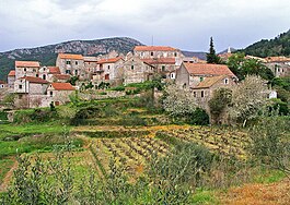
Rudina is a small village on the island of Hvar, in the Adriatic Sea in Croatia. It is located near Stari Grad. The village has a population of 70 people. Most of the population are fishermen. There is a lagoon, Žukova, located there. Rudina has become an escape for the art community during the summer months.

Stari Grad is a town on the northern side of the island of Hvar in Dalmatia, Croatia. One of the oldest towns in Europe, its position at the end of a long, protected bay and next to prime agricultural land has long made it attractive for human settlement. Stari Grad is also a municipality within the Split-Dalmatia County.

<span class="mw-page-title-main">Hvar (town)</span> Town in Split-Dalmatia, Croatia

Hvar is a town and port on the island of Hvar, part of Split-Dalmatia County, Croatia. The municipality has a population of 4,251 (2011) while the town itself is inhabited by 3,771 people, making it the largest settlement on the island of Hvar. It is situated on a bay in the south coast of the island, opposite from the other nearby towns of Stari Grad and Jelsa.

<span class="mw-page-title-main">Slunj</span> Town in Karlovac County, Croatia

Slunj is a town in the mountainous part of Central Croatia, located along the important North-South route to the Adriatic Sea between Karlovac and Plitvice Lakes National Park, on the meeting of the rivers Korana and Slunjčica. Slunj has a population of 1,674, with a total of 5,076 people in the municipality (2011) and is the cultural and social center of the region of Kordun in the vicinity to Bosnia and Herzegovina. Administratively, the town is part of Karlovac County. Slunj is an underdeveloped municipality which is statistically classified as part of the First Category Area of Special State Concern by the Government of Croatia.

<span class="mw-page-title-main">Orebić</span> Municipality in Dubrovnik-Neretva County, Croatia

Orebić is a port town and municipality in the Dubrovnik-Neretva county in Croatia. It is located on the Pelješac peninsula on the Dalmatian coast. Orebić is directly across a strait from the town of Korčula, located on the island of the same name. Ferries service the two towns frequently. Orebić is 112 km (70 mi) from Dubrovnik.

<span class="mw-page-title-main">Benkovac</span> Town in Zadar, Croatia

Benkovac is a town and municipality in the Zadar County, Croatia.

<span class="mw-page-title-main">Šolta</span> Island in Split-Dalmatia County, Croatia

Šolta is an island in Croatia. It is situated in the Adriatic Sea in the central Dalmatian archipelago, west of the island of Brač, south of Split and east of the Drvenik islands, Drvenik Mali and Drvenik Veli. The main settlement is Grohote. Its area is 58.98 km2. and it has a population of 1,700.

<span class="mw-page-title-main">Jelsa, Croatia</span> Municipality in Split-Dalmatia County, Croatia

Jelsa is a town in Croatia, on the island of Hvar, the seat of the eponymous municipality (općina) within the county of Split-Dalmatia.

<span class="mw-page-title-main">Sveti Filip i Jakov</span> Municipality in Zadar County, Croatia

Sveti Filip i Jakov is a municipality in Croatia in Zadar County. It has a total population of 4,606, in the following settlements:

<span class="mw-page-title-main">Vinica, Varaždin County</span> Croatian village and municipality

Vinica is a village and municipality in Croatia in Hrvatsko Zagorje.

<span class="mw-page-title-main">Sveti Ivan Zelina</span> Town in Zagreb, Croatia

Sveti Ivan Zelina is a town in Zagreb County, Croatia.

<span class="mw-page-title-main">Jesenje</span>

Jesenje is a municipality in the Krapina-Zagorje County in Croatia. In the 2011 census, there were a total of 1,560 inhabitants. The absolute majority of the population are Croats at 99.36%. The population is distributed in the following settlements:

<span class="mw-page-title-main">Vrboska</span> Town in Split-Dalmatia County, Croatia

Vrboska is a settlement on the north coast of the island of Hvar in Dalmatia, Croatia, in the Municipality of Jelsa. Founded in the 15th century as a fishing harbour, the town's fortress Church of Sv. Marija was built as a refuge for its inhabitants during the 16th century. Vrboska has a population of 548 at the 2011 census.

<span class="mw-page-title-main">Tvrdalj Castle</span>

Tvrdalj Castle is a castle in Stari Grad, on the island of Hvar, Croatia.

Donje Ceranje is a village within the town Benkovac. It is 5 km (3.1 mi) south of Benkovac near the Vrana Lake.

References

  1. Register of spatial units of the State Geodetic Administration of the Republic of Croatia. Wikidata   Q119585703.
  2. "Population by Age and Sex, by Settlements, 2021 Census". Census of Population, Households and Dwellings in 2021. Zagreb: Croatian Bureau of Statistics. 2022.
  3. Hughes Fowler, Barbara. Hellenistic Poetry: an Anthology. Wisconsin: University of Wisconsin Press. ISBN   0-299-12530-0.
  4. Rhodus, Apollonius. "Argonautica". Greek Texts & Translations. Retrieved 15 August 2016. far onward they sped starting from the Hyllean land, and they left behind all the islands that were beforetime thronged by the Colchians -- the Liburnian isles, isle after isle, Issa, Dysceladus, and lovely Pityeia
  5. Ring, Trudy (1994). International Dictionary of Historic Places - Southern Europe. Chicago: Fitzroy Dearborn.
  6. "Island of Hvar: Pitve". Stari Grad Tourist Board. Stari Grad Tourist Board. Retrieved 15 August 2016.
  7. Census of Population, Households and Dwellings, 31st March 2001, Republic of Croatia: Central Bureau of Statistics, 2001, retrieved 14 July 2009