Intramuros, is the 0.67-square-kilometer (0.26 sq mi) historic walled area within the city of Manila, the capital of the Philippines. It is administered by the Intramuros Administration with the help of the city government of Manila.

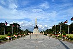
Rizal Park, also known as Luneta Park or simply Luneta, is a historic urban park located in Ermita, Manila. It is considered one of the largest urban parks in the Philippines, covering an area of 58 hectares. The site on where the park is situated was originally known as Bagumbayan during the Spanish colonial period. It is adjacent to the historic Walled City of Intramuros.
The gates of Intramuros refer to the original eight gates of the Walled City of Intramuros in Manila, built during the Spanish colonial era in the Philippines. The gates are called by the original Spanish word for "gate", puerta.

The Royal and Conciliar San Carlos Seminary is the archdiocesan seminary of the Roman Catholic Archdiocese of Manila. It was established in the year 1702, by decree of King Philip V of Spain. At present, the institution houses seminarians belonging to various dioceses in Luzon, particularly from the Metro Manila region.
The Universidad de San Ignacio was a university in the city of Manila which existed during the Spanish colonial era in the Philippines. It was founded in 1590 and is one of the earliest educational institutions built by Europeans in East Asia when it was established by Spanish Jesuits headed by Fr. Antonio Sedeño, S.J. The school ceased its existence following the expulsion of the Jesuits in the archipelago in 1768.

The Plaza de Armas is a public square in Intramuros, Manila. The central plaza of Fort Santiago, it is one of three major plazas in Intramuros, the others being the central Plaza de Roma outside the fort grounds, and Plaza Moriones, a larger plaza outside Fort Santiago which was once a military promenade before it was closed in the 1863 earthquake that devastated Manila. While Plaza Moriones is outside the walls of Fort Santiago, both plazas are often misconstrued for the other.

Plaza San Lorenzo Ruiz or Plaza Lorenzo Ruiz is a major public square in Binondo, Manila, bounded by Quintin Paredes Street to the east and Juan Luna Street to the west, parallel to the Estero de Binondo. It is the plaza that fronts the Minor Basilica of San Lorenzo Ruiz, one of the main churches of the City of Manila, and is considered the center of Binondo as a whole.

McKinley Road is a tree-lined avenue linking the central business districts of Makati and Bonifacio Global City, Taguig in Metro Manila, Philippines. It is a continuation of Ayala Avenue, south of Epifanio de los Santos Avenue (EDSA), which runs for approximately 1.9 kilometers (1.2 mi) through the affluent neighborhoods of Forbes Park and Dasmariñas Village. It is home to the exclusive Manila Polo Club and the Manila Golf and Country Club.

The Ayuntamiento de Manila is a building located at the corner of Andrés Soriano Avenue and Cabildo Street, fronting Plaza de Roma in Intramuros, Manila, Philippines. Also known as the Casas Consistoriales and also nicknamed as the Marble Palace, the Ayuntamiento was the seat of the Manila City Council, which consisted of two alcaldes, eight oidores (judges), a clerk, and a chief constable. Destroyed in World War II and reconstructed thereafter, the building now houses the offices of the Bureau of the Treasury.

The Anda Monument, often erroneously referred to as the Anda Circle after the roundabout it is currently located, is an obelisk monument situated in the boundary of Intramuros and Port Area in central Manila, Philippines. It was erected in honor of Simón de Anda y Salazar, the Governor General of the Philippines from 1770 to 1776. The Anda Circle, the roundabout, is an interchange system at the junction of Bonifacio Drive, Mel Lopez Boulevard, Andres Soriano Avenue, and Roberto Oca Street.

Colegio de Santa Rosa - Manila is a private Catholic school run by the Congregation of the Augustinian Recollect Sisters in Intramuros, Manila, Philippines. It was established on August 30, 1750 as the Beaterio y Casa de Segunda Enseñanza by Mother Paula de la Santissima Trinidad to educate the young Spanish - Filipino women. It was originally an All Girls school until the early 2000 when it converted to a co-ed educational institution. It acquired its present name on 1774 but was also known by several other names including Colegio de Madre Paula and Beaterio y Casa de Enseñanza.

San Ignacio Church in Intramuros, Manila, Philippines, was designed for the Jesuits by architect Félix Roxas Sr., and completed in 1899. It was known as their "Golden Dream" but was destroyed during World War II. Its interiors, embellished with carvings, had been designed by Isabelo Tampinco.
Plaza Mexico is a historic riverside square in Manila, Philippines, located at the west end of Magallanes Drive and Riverside Drive in Intramuros bordering the Pasig River in the north. It is surrounded by the Aduana Building on the south, the Bureau of Immigration Building on the east and the ruins of the Bastión de Maestranza and Puerta de Almacenes on the west. The Pasig River Ferry has a station also named Plaza Mexico located northeast of the square behind the Immigration building. The square was named Plaza Mexico in 1964 to commemorate the 4th centenary of the expedition of Miguel López de Legazpi and Andres de Urdaneta from New Spain (Mexico) and the historic Manila-Acapulco galleon trade relations between the two nations that lasted 250 years.

Plaza de España, also known simply as Plaza España, is a diminutive open space in Intramuros, Manila, Philippines formed by the intersection of Andres Soriano Avenue, Solana Street and Muralla Street. It is a triangular "square" which features a monument to King Philip II of Spain after whom the Philippines was named. The square is one of 47 parks and plazas in the City of Manila maintained by the city's Park Development Office in partnership with the Intramuros Administration. It is surrounded by the Aduana Building, the BPI Intramuros building which replaced the old Santo Domingo Church destroyed during World War II, and the Banco Filipino condominium building built on a portion of the old Ayuntamiento de Manila.

The following is an alphabetical list of articles related to the Philippine capital region of Metro Manila.
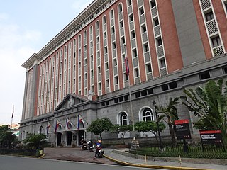
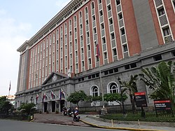
The Palacio del Gobernador is a government building located in Intramuros, Manila, Philippines. It is located southwest from Plaza de Roma and built in its current form in 1976. At present, the building houses the Intramuros Administration, the Commission on Elections and the Home Development Mutual Fund National Capital Region Office. It also previously housed the Bureau of the Treasury until it relocated across Plaza de Roma to the Ayuntamiento de Manila.

Old Town of Cáceres is a historic walled city in Cáceres, Spain.

The Intramuros Administration (IA) is an agency of the Department of Tourism of the Philippines that is mandated to orderly restore, administer, and develop the historic walled area of Intramuros that is situated within the modern City of Manila as well as to insure that the 16th- to 19th-century Philippine-Spanish architecture remains the general architectural style of the walled area.

Plaza Moriones is a public square in Intramuros, Manila. Located in front of the entrance to Fort Santiago, it is one of three major plazas in Intramuros, the others being Plaza de Roma located beyond the fort's grounds, and the Plaza de Armas located inside the fort, to which it is often misconstrued for.

The Benavides Monument is a memorial in the University of Santo Tomas in Manila, Philippines built to commemorate the founder of the University of Santo Tomas, Miguel de Benavides, O.P. Located in front of the UST Main Building, the monument consists of a bronze statue of Benavides rising on top of a granite pedestal. The present monument was unveiled in 1946.