
Pocahontas is a town in Tazewell County, Virginia, United States. It was named for Chief Powhatan's daughter, Pocahontas, who lived in the 17th-century Jamestown Settlement. The town was founded as a company mining town by the Southwest Virginia Improvement Company in 1881. It was the first company mining town in Virginia. The post office opened on June 30, 1882.

Jenkinjones is an unincorporated community and coal town in McDowell County, West Virginia, United States. It lies on the western flanks of Stone Ridge near the border with Tazewell County, Virginia.

The New River Coalfield is located in northeastern Raleigh County and southern Fayette County, West Virginia. Commercial mining of coal began in the 1870s and thrived into the 20th century. The coal in this field is a low volatile coal, known as "smokeless" coals. The seams of coal that have been mined include Sewell, Fire Creek, and Beckley. This is very high quality bituminous coal rated at approximately 15,000 BTU (16,000 kJ). The New River coalfield is named after the north flowing New River. Over 60 coal towns were once located there, supported by independent commercial districts at Beckley, Oak Hill, Mount Hope, and Fayetteville. By the 21st century many coal camps had partially or completely returned to nature. These company towns were located along Dunloup (Loup) Creek, Laurel Creek, White Oak Creek, lower Piney Creek, and, of course, the New River. The mainline of the Chesapeake and Ohio Railway ran right through the center of this coalfield, with spurs branching off in many directions, and rail yards were maintained at Quinnimont, Raleigh, and Thurmond, WV. The Virginian Railway's main line also passed through the western side of the field as well. Companies such as the New River Company, New River & Pocahontas Consolidated Coal Co., and Mary Frances Coal Co. were the largest operators in the New River Coalfield, but there were many smaller ones as well. These companies recruited native born whites, immigrants from Southern and Eastern Europe, and African-Americans from the South to work in their coal mines and railroads. The mines began to close down after World War II and today there are very few active coal mines in the field. The New River Gorge is now the domain of the National Park Service as the New River Gorge National Park and Preserve, and they have done what their budget allows to preserve the coal heritage of the area.

Pocahontas Coalfield, which is also known as the Flat Top-Pocahontas Coalfield, is located in Mercer County/McDowell County, West Virginia and Tazewell County, Virginia. The earliest mining of coal in the coalfield was in Pocahontas, Virginia in 1883 at Pocahontas Mine No. 1, now on the National Register of Historic Places.
Landgraff is an unincorporated community in McDowell County, West Virginia, United States. It is located along U.S. Route 52 and Elkhorn Creek, approximately 6.4 miles (10.3 km) east of the county seat of Welch.

The Elkins Coal and Coke Company Historic District is a historic industrial site near the crossroads village of Bretz in Preston County, West Virginia. It is the site of the last major coke manufacturing facility to use beehive ovens, and was a major industrial site in northern West Virginia in the first half of the 20th century. Surviving elements include a row of 140 beehive ovens. The site was declared a National Historic Landmark in 1983.

Pocahontas Historic District is a national historic district located at Pocahontas in the Pocahontas coalfield, Tazewell County, Virginia. It is near Pocahontas Exhibition Coal Mine, a U.S. National Historic Landmark which was Mine No. 1 of the Pocahontas coalfield. The district encompasses 17 contributing buildings and 1 contributing structure in the town of Pocahontas. Notable buildings include the City Hall (1895), the stone Episcopal Methodist Church, Catholic Church, the old brick medical dispensary, a Synagogue, the first millinery shop in the coalfields and a Masonic Hall.

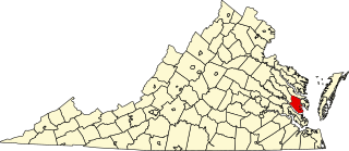
Pocahontas Island is a peninsula in Petersburg, Virginia, once on the opposite side of the Appomattox River from Petersburg. Since 1915 a new channel for the river separated it from Chesterfield County and the former channel no longer separates it from the city. Once a warehouse and wharf-filled urban landscape initially platted in 1749, the island was devastated by a 1993 tornado before citizen involvement caused creation of the Pocahontas Island Historic District, which in 2006 achieved listing on the National Register of Historic Places (NRHP) as a historic district because of its significance in African-American history and for its prehistoric indigenous archeological assets.

Kay Moor, also known as Kaymoor, is the site of an abandoned coal mine, coal-processing plant, and coal town near Fayetteville, West Virginia. The town site is located in the New River Gorge at Kaymoor Bottom (38°03′00″N81°03′17″W). It is linked to the mine portal 560 feet (170 m) above on Sewell Bench (38°02′52″N81°03′58″W) in the wall of the Gorge by conveyors.
This is a list of the National Register of Historic Places listings in Gloucester County, Virginia.

This is a list of the National Register of Historic Places listings in Pocahontas County, West Virginia.

The Nuttallburg Coal Mining Complex and Town Historic District is located near Winona, West Virginia in New River Gorge National Park and Preserve. The townsite is almost directly across from the Kay Moor mine and townsite, now abandoned. Like Kay Moor, the town is built around the railroad line at the bottom of the gorge, with an array of coke ovens and mining structures, as well as a bridge across the New River to South Nuttall.

Pocahontas Fuel Company Store, also known as Norfolk Coal & Coke Company Store and Henderson Market, was a historic Pocahontas Fuel Company company store building located at Maybeury, McDowell County, West Virginia. It was built before 1903, and was a one- to two-story wood-frame building on a stone foundation. It featured a pyramidal roof in one corner.

The Minersville Coke Ovens is an historic, American coke oven site that is located in Carbon Township in Huntingdon County, Pennsylvania.
The National Coal Heritage Area (NCHA) is a federally designated National Heritage Area encompassing a region of thirteen counties in West Virginia that were the source of "smokeless" bituminous coal through much of the 20th century. The National Heritage Area recognizes the area's cultural and historic qualities and serves to promote tourism, historic preservation and economic development in the region. The idea of the NCHA was first proposed in the early 1990s by Congressman Nick Rahall, and was established on November 12, 1996 by the 1996 Omnibus Parks and Public Lands Management Act. The designated area includes Boone, Cabell, Fayette, Logan, Lincoln, McDowell, Mercer, Mingo, Raleigh, Summers, and Wayne counties.
The coal mining communities, or coal towns of McDowell County, West Virginia were situated to exploit the area's rich coal seams. Many of these towns were located in deep ravines that afforded direct access to the coal through the hillsides, allowing mined coal to be dropped or conveyed downhill to railway lines at the valley floor. Many of these encampments were set up as company towns, and when their mines closed, the towns vanished. McDowell County covers much of the Flat Top-Pocahontas Coalfield and a small portion of the Williamson Coalfield.

The Cherry Valley Coke Ovens consisted of 200 coke ovens built by the Leetonia Iron and Coal Company around 1866, near Leetonia, Ohio, United States. The function of the "beehive" coke ovens was to purify coal and turn it into coke. The coke was burned in furnaces that produced iron and steel.

The Walter McDonald Sanders House is a historic house that forms the center of the Sanders House Center complex at Bluefield in Tazewell County, Virginia, United States. It was built between 1894 and 1896, and is a large two-story, three-bay, red brick Queen Anne style dwelling. A two-story, brick over frame addition was built in 1911. The house features a highly decorative, almost full-length, shed-roofed front porch; a pyramidal roof; and a corner turret with conical roof. Also on the property are the contributing limestone spring house, a frame smokehouse which contains a railroad museum, a frame granary, and an early-20th century small frame dwelling known as the Rosie Trigg Cottage, which houses the Tazewell County Visitor Center.

Big Crab Orchard Site is a historic archaeological site located near Tazewell, Tazewell County, Virginia. The Crab Orchard site was patented in 1750, and was one of the first European settlements in Southwest Virginia. Parts of the tract were later owned by Morris Griffith and William Ingles and then acquired by Thomas Witten Sr., who settled here about 1768.

Pocahontas Fuel Company operated mines in the state of Virginia in Boissevain and Amonate, and in West Virginia at Jenkinjones, Bishop, and Itmann. Pocahontas Fuel Company founded the Pocahontas Consolidated Collieries Company in 1907. In 1956 Pocahontas was acquired by the Consolidation Coal Company. Consolidation Coal Company became Consol Energy in 1991. Consol Energy mines coal at Amonate. Pocahontas Fuel Company used the Norfolk & Western Railway bring the coal to ports for shipment.


