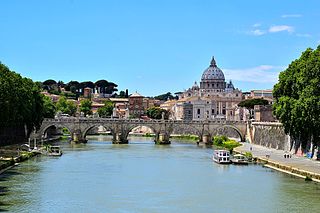
The Tiber is the third-longest river in Italy and the longest in Central Italy, rising in the Apennine Mountains in Emilia-Romagna and flowing 406 km (252 mi) through Tuscany, Umbria, and Lazio, where it is joined by the River Aniene, to the Tyrrhenian Sea, between Ostia and Fiumicino. It drains a basin estimated at 17,375 km2 (6,709 sq mi). The river has achieved lasting fame as the main watercourse of the city of Rome, which was founded on its eastern banks.
The Via Flaminia or Flaminian Way was an ancient Roman road leading from Rome over the Apennine Mountains to Ariminum (Rimini) on the coast of the Adriatic Sea, and due to the ruggedness of the mountains was the major option the Romans had for travel between Etruria, Latium, Campania, and the Po Valley. The section running through northern Rome is where Constantine the Great had his famous vision of the Chi Rho, leading to his conversion to Christianity and the Christianization of the Roman Empire.

The ancient Romans were the first civilization to build large, permanent bridges. Early Roman bridges used techniques introduced by Etruscan immigrants, but the Romans improved those skills, developing and enhancing methods such as arches and keystones. There were three major types of Roman bridge: wooden, pontoon, and stone. Early Roman bridges were wooden, but by the 2nd century stone was being used. Stone bridges used the arch as their basic structure, and most used concrete, the first use of this material in bridge-building.

The Via Aurelia is a Roman road in Italy constructed in approximately 241 BC. The project was undertaken by Gaius Aurelius Cotta, who at that time was censor. Cotta had a history of building roads for Rome, as he had overseen the construction of a military road in Sicily connecting Agrigentum and Panormus.

The Tiber Island is the only river island in the part of the Tiber which runs through Rome. Tiber Island is located in the southern bend of the Tiber.
The Pons Sublicius is the earliest known bridge of ancient Rome, spanning the Tiber River near the Forum Boarium downstream from the Tiber Island, near the foot of the Aventine Hill. According to tradition, its construction was ordered by Ancus Marcius around 642 BC, but this date is approximate because there is no ancient record of its construction. Marcius wished to connect the newly fortified Janiculum Hill on the Etruscan side to the rest of Rome, augmenting the ferry that was there. The bridge was part of public works projects that included building a port at Ostia, at the time the location of worked salt deposits.
The MilvianBridge is a bridge over the Tiber in northern Rome, Italy. It was an economically and strategically important bridge in the era of the Roman Empire and was the site of the famous Battle of the Milvian Bridge in 312, which led to the imperial rule of Constantine.

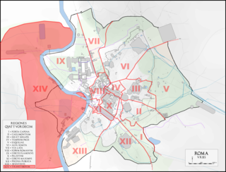
Sant'Angelo is the 11th rione of Rome, Italy, located in Municipio I. Often written as rione XI - Sant'Angelo, it has a coat of arms with an angel on a red background, holding a palm branch in its left hand. In another version, the angel holds a sword in its right hand and a scale in its left.

The Pons Fabricius or Ponte dei Quattro Capi, is the oldest Roman bridge in Rome, Italy, still existing in its original state. Built in 62 BC, it spans half of the Tiber River, from the Campus Martius on the east side to Tiber Island in the middle. Quattro Capi refers to the two marble pillars of the two-faced Janus herms on the parapet, which were moved here from the nearby Church of St Gregory in the 14th century.

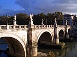
Ponte Sant'Angelo, originally the Aelian Bridge or Pons Aelius, is a Roman bridge in Rome, Italy, completed in 134 AD by Roman Emperor Hadrian, to span the Tiber from the city centre to his newly constructed mausoleum, now the towering Castel Sant'Angelo. The bridge is faced with travertine marble and spans the Tiber with five arches, three of which are Roman; it was approached by means of a ramp from the river. The bridge is now solely pedestrian and provides a scenic view of Castel Sant'Angelo. It links the rioni of Ponte, and Borgo, to whom the bridge administratively belongs.

The Pons Cestius is an ancient Roman bridge connecting the right bank of the Tiber with the west of the Tiber Island in Rome, Italy. In Late Antiquity, the bridge was replaced and renamed the Pons Gratiani. It is also known as the Italian: Ponte San Bartolomeo, lit. 'Bridge of Saint Bartholomew'. No more than one third of the present stone bridge is of ancient material, as it was entirely rebuilt and extended in the 19th century, after numerous earlier restorations.

Ponte Sisto is a bridge in Rome's historic centre, spanning the river Tiber. It connects Via dei Pettinari in the Rione of Regola to Piazza Trilussa in Trastevere. The construction of the current bridge occurred between 1473 and 1479, and was commissioned by Pope Sixtus IV, after whom it is named, from the architect Baccio Pontelli, who reused the foundations of a prior Roman bridge, the Pons Aurelius, which had been destroyed during the early Middle Ages. Currently traffic on the bridge is restricted to pedestrians.

The Pons Neronianus or Bridge of Nero was an ancient bridge in Rome built during the reign of the emperors Caligula or Nero to connect the western part of the Campus Martius with the Ager Vaticanus, where the Imperial Family owned land along the Via Cornelia.
The Pons Agrippae was an ancient bridge across the River Tiber in Rome. It was located 160 metres above the Ponte Sisto, and is known from an inscribed cippus set up by the curatores riparum during the Principate of the Emperor Claudius, suggesting it was built during or before the reign of Claudius. It was restored in 147 AD. The bridge is named after Marcus Vipsanius Agrippa, a close friend of the Emperor Augustus. Agrippa married Julia, the daughter of Augustus, and the couple lived in a villa on the opposite bank of the River Tiber. To connect his villa to the Field of Mars, where Agrippa had built several important monuments, it has been suggested that Agrippa constructed the Pons Agrippae.

The Pons Probi was a bridge over the River Tiber in Ancient Rome, just south of Porta Trigemina.

Lungotevere is an alley or boulevard running along the river Tiber within the city of Rome. The building of the Lungoteveres required the demolition of the former edifices along the river banks and the construction of retaining walls called muraglioni.

Ponte Palatino, also known as Ponte Inglese, is a bridge that links Lungotevere Aventino to Lungotevere Ripa in Rome (Italy), in the Rioni Ripa and Trastevere.
The Regio XIV Transtiberim is the fourteenth regio of imperial Rome, under Augustus's administrative reform. Meaning "across the Tiber", the Regio took its name from its position on the west bank of the Tiber River.