Poolesville, Maryland

Last updated

Poolesville, Maryland
2016-10-13 10 10 35 View west along Maryland State Route 107 (Fisher Avenue) at Norris Road in Poolesville, Montgomery County, Maryland.jpg
View west along Maryland State Route 107 (Fisher Avenue) at Norris Road
Flag of Poolesville, Maryland.png
Poolesville timeless charm.png
Montgomery County Maryland Incorporated and Unincorporated areas Poolesville Highlighted.svg
Location of Poolesville, Maryland
Coordinates: 39°07′55″N77°24′34″W / 39.13194°N 77.40944°W / 39.13194; -77.40944
Country Flag of the United States.svg United States
State Flag of Maryland.svg  Maryland
County Flag of Montgomery County, Maryland.svg Montgomery
Settled1760;264 years ago (1760)
Incorporated 1867;157 years ago (1867)
Government
  TypeBoard of Commissioners/Manager
Area
[1]
  Total3.95 sq mi (10.23 km2)
  Land3.93 sq mi (10.18 km2)
  Water0.02 sq mi (0.05 km2)
Elevation
[2]
390 ft (120 m)
Population
 (2020)
  Total5,742
  Density1,460.70/sq mi (564.00/km2)
Time zone UTC-5 (EST)
  Summer (DST) UTC-4 (EDT)
ZIP code
20837
Area code(s) 301, 240
FIPS code 24-62850
GNIS feature ID2391366 [2]
Website http://www.poolesvillemd.gov

Poolesville is a U.S. town in the western portion of Montgomery County, Maryland. The population was 5,742 at the 2020 United States Census. [3] It is surrounded by (but is technically not part of) the Montgomery County Agricultural Reserve, [4] and is considered a distant bedroom community for commuters to Washington, D.C.

Contents

The name of the town comes from the brothers John Poole, Sr. and Joseph Poole, Sr. who owned land and slaves in what is now Poolesville. Due to an historical anomaly, until 2010 the legal name of the town was "The Commissioners of Poolesville". [5] Residents overwhelmingly voted to formally change the name to "The Town of Poolesville" in the November 2010 general election. [6]

History

In 1760, brothers John Poole, Sr. and Joseph Poole, Sr. purchased 160 acres (0.65 km2; 0.25 sq mi) acres in the area that is now Poolesville. Thirty-three years later, John Poole, Jr. used a 15 acres (0.061 km2) tract that he inherited from his father to build a log store and subdivided the tract, selling portions to a number of other merchants. The settlement grew from there and was incorporated in 1867. [7]

During the Civil War, Union military leaders realized that the shallow fords of the Potomac River posed a threat to the capital city. At certain times of the year, the Potomac River is shallow enough to cross and thus thousands of troops were moved to both Darnestown and Poolesville. The Corps of Observation was established just outside Poolesville and soldiers were stationed near the river to monitor potential Confederate incursions into Maryland. During the winter of 1861–1862, it is estimated that 20,000 Union troops were stationed in or around the town. There were no battles fought in Poolesville; however, the infamous Battle of Ball's Bluff was fought nearby on October 21, 1861. Hundreds of Union soldiers who were stationed in Poolesville were killed in this battle that was badly managed by inexperienced Union generals. [8]

There were several Confederate raids into the town during the war, and the Confederate Army invaded Maryland by crossing the Potomac near Poolesville in 1862 and 1864. The old Poolesville Methodist Church cemetery contains the remains of approximately twenty soldiers who either were killed in action at Ball's Bluff or who died of illness while in camp. [9]

The Seneca Schoolhouse, a small one-room schoolhouse of red sandstone, was built in Poolesville in 1866 to educate the children of the stone cutters who worked at the Seneca Quarry. Operating as the Seneca Schoolhouse Museum, it provides tours to schoolchildren so that they can experience a typical school day as it would have been on March 13, 1880. [10] [11]

The Kunzang Palyul Choling Buddhist temple opened in Poolesville in 1985. [12]

The Poolesville Historic District was listed in 1975 on the National Register of Historic Places. [13]

In December 2020, White's Ferry, a ferry service west of the town across the Potomac River that a number of citizens have depended on for their livelihoods, ceased service due to a legal conflict between the ferry and Rockland Farm over ownership of land on the banks of the river. [14] As of April 2024, the ferry has not yet reopened due to the legal conflict, though the owners have offered to donate the ferry to the Montgomery County government. [15]

Geography

According to the United States Census Bureau, the town has a total area of 3.95 square miles (10.23 km2), of which 3.93 square miles (10.18 km2) is land and 0.02 square miles (0.05 km2) is water. [16]

Poolesville lies off Montgomery County's main axis of suburban development along the Interstate 270 and Maryland State Route 355 corridor, separated from the contiguous Maryland suburbs of Washington by the rural lands of the county agricultural reserve, where new housing and commercial starts are restricted.

Government

Poolesville is governed by five commissioners elected in staggered 4-year terms. Commissioners are not paid. The commissioners elect among themselves a president (known informally as "the mayor") and vice president. A Town Manager is responsible for the day-to-day operations of the town. Six Boards and Commissions assist the commissioners: the Planning Commission, Parks Board, Board of Elections, Sign Review Board, Board of Zoning Appeals, and Ethics Commission. [17]

Demographics

Historical population
CensusPop.Note
1900 236
1910 174−26.3%
1920 32586.8%
1930 197−39.4%
1940 2043.6%
1950 161−21.1%
1960 29885.1%
1970 34917.1%
1980 3,428882.2%
1990 3,79610.7%
2000 5,15135.7%
2010 4,883−5.2%
2020 5,74217.6%
U.S. Decennial Census [18]
2010–2020 [3]

2000 census

As of the census [19] of 2000, there were 5,151 people, 1,601 households, and 1,402 families residing in the town. The population density was 1,333.8 inhabitants per square mile (515.0/km2). There were 1,630 housing units at an average density of 422.1 per square mile (163.0/km2). The racial makeup of the town in 2000 was 93.57% White, 2.85% African American, 0.49% Native American, 1.09% Asian, 1.4% from other races, and 1.28% from two or more races. Hispanic or Latino of any race were 2.68% of the population.

There were 1,601 households, out of which 56.8% had children under the age of 18 living with them, 75.6% were married couples living together, 9.0% had a female householder with no husband present, and 12.4% were non-families. 9.3% of all households were made up of individuals, and 2.0% had someone living alone who was 65 years of age or older. The average household size was 3.22 and the average family size was 3.44.

In the town, the population was spread out, with 35.0% under the age of 18, 5.6% from 18 to 24, 32.2% from 25 to 44, 24.0% from 45 to 64, and 3.2% who were 65 years of age or older. The median age was 35 years. For every 100 females, there were 96.5 males. For every 100 females age 18 and over, there were 94.2 males.

The median income for a household in the town was $85,092, and the median income for a family was $88,916. Males had a median income of $60,596 versus $42,051 for females. The per capita income for the town was $30,211. About 2.5% of families and 2.6% of the population were below the poverty line, including 3.0% of those under age 18 and 7.5% of those age 65 or over.

2010 census

As of the census [20] of 2010, there were 4,883 people, 1,602 households, and 1,348 families residing in the town. The population density was 1,242.5 inhabitants per square mile (479.7/km2). There were 1,663 housing units at an average density of 423.2 per square mile (163.4/km2). The racial makeup of the town was 88.4% White, 5.2% African American, 0.5% Native American, 2.1% Asian, 1.4% from other races, and 2.5% from two or more races. Hispanic or Latino of any race were 7.0% of the population.

There were 1,602 households, of which 45.4% had children under the age of 18 living with them, 71.0% were married couples living together, 8.8% had a female householder with no husband present, 4.4% had a male householder with no wife present, and 15.9% were non-families. 12.2% of all households were made up of individuals, and 3% had someone living alone who was 65 years of age or older. The average household size was 3.04 and the average family size was 3.30.

The median age in the town was 41.5 years. 27.7% of residents were under the age of 18; 8.6% were between the ages of 18 and 24; 19.2% were from 25 to 44; 38.4% were from 45 to 64; and 6.1% were 65 years of age or older. The gender makeup of the town was 49.2% male and 50.8% female.

Education

Poolesville is served by Montgomery County Public Schools. Three schools are located in Poolesville: Poolesville High School, [21] John Poole Middle School, [22] and Poolesville Elementary School. [23] Monacacy Elementary School [24] in Dickerson also feeds into John Poole MS.

Transportation

MD 107 eastbound in Poolesville 2020-06-24 15 48 34 View east along Maryland State Route 107 (Fisher Avenue) at Maryland State Route 109 (Elgin Road) in Poolesville, Montgomery County, Maryland.jpg
MD 107 eastbound in Poolesville

Two state highways serve Poolesville. Maryland Route 107 extends southeast from the center of town, joining Maryland Route 28 on its way to Rockville. Maryland Route 109 proceeds northeast from the center of town, intersecting MD 28 on its way to Interstate 270 in Hyattstown.

Notable people

Related Research Articles

<span class="mw-page-title-main">Westernport, Maryland</span> Town in Maryland, United States

Westernport is a town in Allegany County, Maryland, United States, along the Georges Creek Valley. It is part of the Cumberland, MD-WV Metropolitan Statistical Area. The population was 1,888 at the 2010 census.

<span class="mw-page-title-main">Burkittsville, Maryland</span> Town in Maryland, United States

Burkittsville is a historic village in Frederick County, Maryland, United States. The village lies in the southern Middletown Valley along the eastern base of South Mountain.

<span class="mw-page-title-main">Barnesville, Maryland</span> Town in Maryland, United States

Barnesville is a town in Montgomery County, Maryland, United States. It was incorporated in 1888. The population was 144 at the 2020 census.

<span class="mw-page-title-main">Brookmont, Maryland</span> Census-designated place in Maryland, United States

Brookmont is a census-designated place and unincorporated area in Montgomery County, Maryland, United States. As of the 2020 census, it had a population of 3,751. Brookmont is often considered part of neighboring Bethesda because it falls within Bethesda's 20816 zip code.

<span class="mw-page-title-main">Cabin John, Maryland</span> Census-designated place in Maryland, United States

Cabin John is a census-designated place and unincorporated area in Montgomery County, Maryland, United States. As of the 2020 census, it had a population of 2,459. Overlooking the Potomac River, it is a suburb of Washington, D.C.

<span class="mw-page-title-main">Chevy Chase Village, Maryland</span> Town in Maryland, United States

Chevy Chase Village is an incorporated municipality in Montgomery County, Maryland, United States, bordering Washington, D.C. The population was 2,049 as of the 2020 census. The town was the wealthiest in Maryland as of 2017, with a median income of over $250,000, the highest income bracket listed by the census bureau, and a median home value of $1,823,800.

<span class="mw-page-title-main">Darnestown, Maryland</span> Census-designated place in the United States

Darnestown is a United States census-designated place (CDP) and an unincorporated area in Montgomery County, Maryland. The CDP is 17.70 square miles (45.8 km2) with the Potomac River as its southern border and the Muddy Branch as much of its eastern border. Seneca Creek borders portions of its north and west sides. The Travilah, North Potomac, and Germantown census-designated places are adjacent to it, as is the city of Gaithersburg. Land area for the CDP is 16.39 square miles (42.4 km2). As of the 2020 census, the Darnestown CDP had a population of 6,723, while the village of Darnestown is considerably smaller in size and population. Downtown Washington, D.C. is about 22 miles (35 km) to the southeast.

<span class="mw-page-title-main">Glen Echo, Maryland</span> Town in Maryland, United States

Glen Echo is a town in Montgomery County, Maryland, United States, that was chartered in 1904. The population was 279 at the 2020 census.

<span class="mw-page-title-main">Laytonsville, Maryland</span> Town in Maryland, United States

Laytonsville is a town in Montgomery County, Maryland, United States. The population was 572 at the 2020 census, up from 353 in 2010. Laytonsville was incorporated in 1892.

<span class="mw-page-title-main">Potomac, Maryland</span> Census-designated place in Maryland, United States

Potomac is an unincorporated community and census-designated place in Montgomery County, Maryland, United States. As of the 2020 census, it had a population of 47,018. It is named after the nearby Potomac River. A part of the Washington metropolitan area, many Potomac residents work in nearby Washington, D.C., and Northern Virginia.

<span class="mw-page-title-main">Travilah, Maryland</span> Census-designated place in Maryland

Travilah is a United States census-designated place and an unincorporated area in Montgomery County, Maryland. It is 17.28 square miles (44.8 km2) located along the north side of the Potomac River, and surrounded by the communities of Potomac, North Potomac, and Darnestown—all census-designated places. It had a population of 11,985 as of the 2020 census.

<span class="mw-page-title-main">Bolivar, West Virginia</span> Town in West Virginia, United States

Bolivar is a town in Jefferson County, West Virginia, United States. The population was 1,072 at the 2020 census. The town is named for South American revolutionary leader Simón Bolívar. Located in West Virginia's Eastern Panhandle, it is part of the northwestern fringes of the Washington metropolitan area.

<span class="mw-page-title-main">Shepherdstown, West Virginia</span> Town in West Virginia, United States

Shepherdstown is a town in Jefferson County, West Virginia, United States, located in the lower Shenandoah Valley along the Potomac River. Home to Shepherd University, the town's population was 1,531 at the time of the 2020 census. The town was established in 1762 along with Romney; they are the oldest towns in West Virginia.

<span class="mw-page-title-main">Seneca, Wood County, Wisconsin</span> Town in Wisconsin, United States

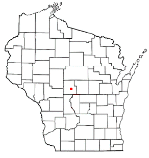
The Town of Seneca is located in Wood County, Wisconsin, United States. The population was 1,202 at the 2000 census.

<span class="mw-page-title-main">Chevy Chase (town), Maryland</span> Town in Montgomery County, Maryland, US

Chevy Chase —formally, the Town of Chevy Chase—is an incorporated town in Montgomery County, Maryland, United States. The population was 2,904 at the 2020 census.

<span class="mw-page-title-main">White's Ferry</span> Ferry crossing the Potomac River

White's Ferry, originally Conrad's Ferry, is an inactive cable ferry service that carried cars, bicycles, and pedestrians across the Potomac River between Loudoun County, Virginia and Montgomery County, Maryland, and is the last one of its kind to cross the Potomac. The location offered fishing services and water recreation including canoeing. It transported between 600 and 800 customers daily until its operations were suspended indefinitely in 2020 due to a legal dispute over the land surrounding it.

<span class="mw-page-title-main">Dickerson, Maryland</span> Unincorporated community in Maryland, United States

Dickerson is an unincorporated community in Montgomery County, Maryland. It is on Maryland Route 28, between Sugarloaf Mountain and the Potomac River. It is a community near the town of Poolesville, Maryland. Dickerson is 61.5 square miles (159 km2).

<span class="mw-page-title-main">Maryland Route 107</span> State highway in Montgomery County, Maryland, US

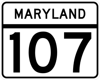
Maryland Route 107 is a state highway in the U.S. state of Maryland. Known for most of its length as Whites Ferry Road, the highway runs 4.79 miles (7.71 km) from MD 109 in Poolesville east to MD 28 in Dawsonville. MD 107 connects the western Montgomery County town of Poolesville with Rockville and Gaithersburg via MD 28. The highway and county-maintained Whites Ferry Road west of Poolesville connect those cities with White's Ferry, a Potomac River ferry north of Leesburg, Virginia. MD 107 was constructed from Dawsonville to Poolesville in the late 1910s. The highway was extended west part of the way to White's Ferry in the late 1920s and early 1930s. The western terminus of MD 107 was truncated at Poolesville in the mid-1970s.

<span class="mw-page-title-main">Beallsville, Maryland</span> Community in Montgomery County, Maryland, United States

Beallsville is an unincorporated community in Montgomery County, Maryland, United States. It is a small community located north of Poolesville.Notable people are Charlotte Mallow and Josephine Mallow, well known race car drivers. The area is also known for wild chickens and a puppy named “Dixie”, named after the Dixie Chicks. The ZIP Code for Beallsville is 20839.

<span class="mw-page-title-main">Seneca, Maryland</span> Unincorporated community in Maryland, United States

Seneca is an unincorporated community in Montgomery County, Maryland, United States. It is located near the intersection of River Road and Seneca Creek, not far from the Chesapeake and Ohio Canal and Potomac River. Its history goes back before the American Revolutionary War and it thrived when the canal was operating—having several warehouses, mills, a store, a hotel, and a school. Fighting occurred in the area on more than one occasion during the American Civil War. The community declined as the C&O Canal declined.

References

  1. "2020 U.S. Gazetteer Files". United States Census Bureau. Retrieved April 26, 2022.
  2. 1 2 U.S. Geological Survey Geographic Names Information System: Poolesville, Maryland
  3. 1 2 "QuickFacts: Poolesville town". United States Census Bureau. Retrieved August 17, 2021.
  4. Criss, Jeremy V. "Montgomery County's Agricultural Reserve and Agricultural Industry" (PDF). Archived from the original (PDF) on September 29, 2013. Retrieved October 11, 2015. This reference has a map of the Montgomery Country Agricultural Reserve; the Poolesville town limits are delineated by the white area inside the light green Agricultural Reserve portion of the map in western Montgomery County.
  5. Davis, Rande (September 24, 2010). "Poolesville Commissioners Seek to Change Name of Town" (PDF). The Monocacy Monocle. p. 1. Archived (PDF) from the original on November 2, 2021.
  6. Davis, Rande (November 19, 2010). "Stump and Brown Sworn in as Commissioners" (PDF). The Monocacy Monocle. Archived (PDF) from the original on November 2, 2021.
  7. "A Brief History of Poolesville". Town of Poolesville - Charles W. Elgin Sr. Archived from the original on June 22, 2007. Retrieved July 14, 2007.
  8. Morgan, James A. III (2011). A Little Short of Boats: The Battle of Ball's Bluff and Edwards Ferry, October 21-22, 1861. El Dorado Hills, CA: Savas Beatie. ISBN   978-1-61121-066-8.
  9. A Little Short of Boats: The Fights at Ball's Bluff and Edwards Ferry, October 21–22, 1861. A History and Tour Guide ISBN   978-0-961-84940-5 p. 63
  10. Sheir, Rebecca (March 20, 2015). "Kids Live History At One-Room Seneca Schoolhouse In Maryland". WAMU 88.5. Retrieved October 12, 2015.
  11. "Seneca Schoolhouse". Historic Medley District, Preserving the Historic Heritage of Western Montgomery County, Maryland. Retrieved October 12, 2015.
  12. Tierney, Meghan (June 9, 2010). "Donors save Poolesville Buddhist temple". Gazette.net, Maryland Newspapers Online. Retrieved October 12, 2015.
  13. "National Register Information System". National Register of Historic Places . National Park Service. April 15, 2008.
  14. "Historic White's Ferry, the last remaining ferry across Potomac River, shuts down service". WJLA. December 28, 2020. Retrieved December 28, 2020.
  15. "Owners offer to donate White's Ferry to Montgomery County in hopes of restarting operations". NBC Washington. April 17, 2024. Archived from the original on April 17, 2024. Retrieved June 1, 2024.
  16. "US Gazetteer files 2010". United States Census Bureau. Archived from the original on February 20, 2011. Retrieved January 25, 2013.
  17. "Government of Poolesville - General Information". Town of Poolesville. Archived from the original on July 21, 2007. Retrieved July 14, 2007.
  18. "Census of Population and Housing". Census.gov. Retrieved June 4, 2015.
  19. "U.S. Census website". United States Census Bureau . Retrieved January 31, 2008.
  20. "U.S. Census website". United States Census Bureau . Retrieved January 25, 2013.
  21. "..:: Poolesville High School ::.. Home of the Falcons". March 11, 2007. Archived from the original on March 11, 2007. Retrieved April 9, 2020.
  22. "Poole Middle School". www.montgomeryschoolsmd.org. Retrieved April 9, 2020.
  23. "Poolesville ES". www2.montgomeryschoolsmd.org. Retrieved April 9, 2020.
  24. "Monocacy ES". www2.montgomeryschoolsmd.org. Retrieved April 9, 2020.
  25. "PLATER, Thomas, (1769 - 1830) - Biographical Information". United States Congress . Retrieved July 14, 2007.