Vancouver Island is an island in the northeastern Pacific Ocean and part of the Canadian province of British Columbia. The island is 456 km (283 mi) in length, 100 km (62 mi) in width at its widest point, and 32,100 km2 (12,400 sq mi) in total area, while 31,285 km2 (12,079 sq mi) are of land. The island is the largest by area and the most populous along the west coasts of the Americas.
Kruzof Island is an island in the Alexander Archipelago in southeastern Alaska at 57°10′14″N135°40′29″W. It is about 16 km (10 mi) west of Sitka, and is part of the City and Borough of Sitka. It was named in 1805 by Captain U.T. Lisianski as Crooze Island, after a Russian Admiral. It hosts the region's only volcano, Mount Edgecumbe.

Quadra Island is a large island off the eastern coast of Vancouver Island, in British Columbia, Canada. It is part of the Discovery Islands, in the Strathcona Regional District.

Juan Francisco de la Bodega y Quadra was a Spanish Criollo naval officer operating in the Americas. Assigned to the Pacific coast Spanish Naval Department base at San Blas, in Viceroyalty of New Spain, he explored the Northwest Coast of North America as far north as present day Alaska. Bodega Bay in California is named for him.

Discovery Bay is an unincorporated community in Jefferson County, Washington. The community of Discovery Bay is an area near the intersection of U.S. Route 101 and State Route 20, at the foot of Discovery Bay – roughly midway between the larger communities of Port Townsend to the northeast and Sequim to the northwest. It is a mix of residential areas and commercial enterprises, including crabbing, oystering, clamming, timbering, security training and gravel extraction. A few restaurants and stores on US 101 near SR 20 primarily serve drivers and truckers along US 101.
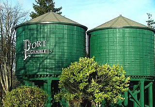
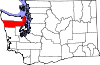
Port Gamble is an unincorporated community on the northwestern shore of the Kitsap Peninsula in Kitsap County, Washington, United States. It is also a small, eponymous bay, along which the community lies, near the entrance to Hood Canal. The unincorporated communities of Port Gamble and Little Boston, part of Kitsap County, lie on the west and the east side, respectively, of the mouth of this bay. The Port Gamble Historic District, a U.S. National Historic Landmark, covers one of the nation's best-preserved western lumber towns.

Dionisio Alcalá Galiano was a Spanish naval officer, cartographer, and explorer. He mapped various coastlines in Europe and the Americas with unprecedented accuracy using new technology such as chronometers. He commanded an expedition that explored and mapped the Strait of Juan de Fuca and the Strait of Georgia, and made the first European circumnavigation of Vancouver Island. He reached the rank of brigadier and died during the Battle of Trafalgar.

James Preston Delgado is a maritime archaeologist, historian, maritime preservation expert, author, television host, and explorer.

The Vancouver Expedition (1791–1795) was a four-and-a-half-year voyage of exploration and diplomacy, commanded by Captain George Vancouver of the Royal Navy. The British expedition circumnavigated the globe and made contact with five continents. The expedition at various times included between two and four vessels, and up to 153 men, all but 6 of whom returned home safely.
During the Age of Discovery, the Spanish Empire undertook several expeditions to the Pacific Northwest of North America. Spanish claims to the region date to the papal bull of 1493, and the Treaty of Tordesillas signed in 1494. In 1513, this claim was reinforced by Spanish explorer Vasco Núñez de Balboa, the first European to sight the Pacific Ocean, when he claimed all lands adjoining this ocean for the Spanish Crown. Spain only started to colonize the claimed territory north of present-day Mexico in the 18th century, when it settled the northern coast of Las Californias.
Francisco de Eliza y Reventa was a Spanish naval officer, navigator, and explorer. He is remembered mainly for his work in the Pacific Northwest. He was the commandant of the Spanish post in Nootka Sound on Vancouver Island, and led or dispatched several exploration voyages in the region, including the Strait of Juan de Fuca and the Strait of Georgia.

José María Narváez was a Spanish naval officer, explorer, and navigator notable for his work in the Gulf Islands and Lower Mainland of present-day British Columbia. In 1791, as commander of the schooner Santa Saturnina, he led the first European exploration of the Strait of Georgia, including a landing on present-day British Columbia's Sunshine Coast. He also entered Burrard Inlet, the site of present-day Vancouver, British Columbia.
Juan Carrasco was a Spanish naval officer, explorer, and navigator. He is remembered mainly for his work in the Pacific Northwest during the late 18th century. He was second in command of the 1791 voyage of José María Narváez, the first European exploration of the Strait of Georgia.
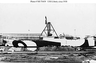
USAT Liberty was a United States Army cargo ship torpedoed by Japanese submarine I-166 in January 1942 and beached on the island of Bali, Indonesia. She had been built as a Design 1037 ship for the United States Shipping Board in World War I and had served in the United States Navy in that war as animal transport USS Liberty (ID-3461). She was also notable as the first ship constructed at Federal Shipbuilding, Kearny, New Jersey. In 1963 a volcanic eruption moved the ship off the beach, and Liberty's wreck is now a popular dive site.

La Princesa was a Spanish frigate or corvette built at the Spanish naval base at San Blas and launched in 1778. She is sometimes called a frigate and sometimes a corvette. At the time a corvette was similar to a frigate in that both were three-masted, ship-rigged warships, but corvettes were slightly smaller and had a single deck instead of two. The exact specifications of La Princesa are not known. La Princesa was designed with storage enough to sail for a year without having to restock. She was built for durability rather than speed. Like La Favorita, a similar corvette stationed at San Blas, La Princesa was heavily used, serving for over three decades, playing an important role in the exploration of the Pacific Northwest as well as the routine work of provisioning the missions of Alta California. During her 1779 voyage the Princesa carried six four-pounder cannons and four three-pounders, and had a crew complement of 98. The Princesa carried 26 cannons in 1789 when Esteban José Martínez took control of Nootka Sound.
Sutil was a brig-rigged schooner built in 1791 by the Spanish Navy at San Blas, New Spain. It was nearly identical to Mexicana, also built at San Blas in 1791. Both vessels were built for exploring the newly discovered Strait of Georgia, carried out in 1792 under Dionisio Alcalá Galiano, on Sutil, and Cayetano Valdés y Flores, on Mexicana. During this voyage the two Spanish vessels encountered the two British vessels under George Vancouver, HMS Discovery and HMS Chatham, which were also engaged in exploring the Strait of Georgia. The two expeditions cooperated in surveying the complex channels between the Strait of Georgia and Queen Charlotte Strait, in the process proving the insularity of Vancouver Island. After this first voyage Sutil continued to serve the San Blas Naval Department, making various voyages to Alta California and the Pacific Northwest coast.
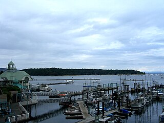
Nanaimo Harbour, also known as the Port of Nanaimo, is a natural harbour on the east coast of Vancouver Island in the Canadian province of British Columbia. The city of Nanaimo runs along the west side of the harbour. Three islands, Newcastle, Protection, and Gabriola, along with Duke Point, form the eastern edge. The Port of Nanaimo includes the Inner Harbour, Nanaimo River estuary, Departure Bay, the waters on the east side of Newcastle and Protection Islands, and Northumberland Channel. The port is under the management of the Nanaimo Port Authority.
North West America was a British merchant ship that sailed on maritime fur trading ventures in the late 1780s. It was the first non-indigenous vessel built in the Pacific Northwest. In 1789 it was captured at Nootka Sound by Esteban José Martínez of Spain during the Nootka Crisis, after which it became part of the Spanish Navy and was renamed Santa Gertrudis la Magna and later Santa Saturnina.
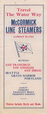
Charles R. McCormick Lumber Company was founded in 1908 by Charles R. McCormick in San Francisco, California. McCormick purchased a mill site in St. Helens, and formed the Helens Mill Company. To feed the mill McCormick's St. Helens Timber Company also purchased 4,000 acres of timber. In 1912 McCormick formed the St. Helens Lumber Company as parent company over Helens Mill Company and the St. Helens Timber Company. In 1912 McCormick expanded the company with a second sawmill, a creosoting plant and shipyard, the St. Helens shipyard. McCormick also expanded into San Diego, California with a railroad ties factory, to supply Santa Fe Railway and the mines of Utah, Arizona, New Mexico, and northern Mexico. At the San Diego site, he built a dock to unload his timbers. With the Great Depression slow down, McCormick closed dock at San Diego in April 1931.

Discovery Bay is a small bay connected to the Strait of Juan de Fuca on the coast of the Olympic Peninsula in Washington state; it was also historically called Port Discovery. An unincorporated community also named Discovery Bay lies in Jefferson County at the southern end of the bay.