Martin County is a county located in the Treasure Coast region of the state of Florida, in the United States. As of the 2010 census, the population was 146,318. Its county seat is Stuart. Martin County is in the Port St. Lucie, FL Metropolitan Statistical Area.

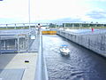
A lock is a device used for raising and lowering boats, ships and other watercraft between stretches of water of different levels on river and canal waterways. The distinguishing feature of a lock is a fixed chamber in which the water level can be varied; whereas in a caisson lock, a boat lift, or on a canal inclined plane, it is the chamber itself that rises and falls.

Lake Okeechobee, also known as Florida's Inland Sea, is the largest freshwater lake in the state of Florida. It is the eighth largest natural freshwater lake among the 50 states of the United States and the second-largest natural freshwater lake contained entirely within the contiguous 48 states.

The Caloosahatchee River is a river on the southwest Gulf Coast of Florida in the United States, approximately 67 miles (108 km) long. It drains rural areas on the northern edge of the Everglades, east of Fort Myers. An important link in the Okeechobee Waterway, a manmade inland waterway system of southern Florida, the river forms a tidal estuary along most of its course and has become the subject of efforts to restore and preserve the Everglades.

Port Mayaca is a sparsely populated place located in western Martin County, Florida, United States, on the eastern side of Lake Okeechobee.

The Okeechobee Waterway or Okeechobee Canal is a relatively shallow artificial waterway in the United States, stretching across Florida from Fort Myers on the west coast to Stuart on Florida's east coast. The waterway can support tows such as barges or private vessels up to 50 feet wide x 250 feet long which draw less than 10 feet, as parts of the system, especially the locks may have low water depths of just ten feet. The system of channels runs through Lake Okeechobee and consists of the Caloosahatchee River to the west of the lake and the St. Lucie Canal (C-44) east of the lake.
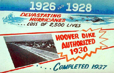
The Herbert Hoover Dike is a dike around the waters of Lake Okeechobee in Florida.
The Cayuga–Seneca Canal is a canal in New York, United States. It is now part of the New York State Canal System.
The Oswego Canal is a canal in the New York State Canal System located in New York, United States. Opened in 1828, it is 23.7 miles (38.1 km) in length, and connects the Erie Canal at Three Rivers to Lake Ontario at Oswego. The canal has a depth of 14 ft, with seven locks spanning the 118 ft change in elevation.

The Champlain Canal is a 60-mile (97 km) canal that connects the south end of Lake Champlain to the Hudson River in New York. It was simultaneously constructed with the Erie Canal and is now part of the New York State Canal System and the Lakes to Locks Passage.
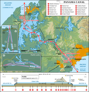
The Panama Canal locks are a lock system that lifts ships up 85 feet to the main elevation of the Panama Canal and down again. The original canal had a total of six steps for a ship's passage. The total length of the lock structures, including the approach walls, is over 1.9 miles (3 km). The locks were one of the greatest engineering works ever to be undertaken when they opened in 1914. No other concrete construction of comparable size was undertaken until the Hoover Dam, in the 1930s.
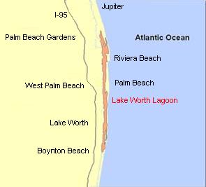
The Lake Worth Lagoon is a lagoon located in Palm Beach County, Florida. It runs parallel to the coast, and is separated from the Atlantic Ocean by barrier beaches, including Palm Beach Island. The lagoon is connected to the Atlantic Ocean by two permanent, man-made inlets.
State Road 76, also known and signed as Kanner Highway, is a 31.504-mile-long (50.701 km) northeast-southwest state highway connecting Port Mayaca on the shore of Lake Okeechobee at the intersection with US 98-441 with Stuart on the shore of the St. Lucie River near the Atlantic Ocean and the Treasure Coast at an intersection with US 1. It parallels the nearby St. Lucie Canal, a navigable waterway connecting the lake and the ocean.

The St. Lucie River is a 35-mile-long (56 km) estuary linked to a coastal river system in St. Lucie and Martin counties in the Florida, United States. The St. Lucie River and St. Lucie Estuary are an "ecological jewel" of the Treasure Coast, central to the health and well-being of the surrounding communities. The river is part of the larger Indian River Lagoon system, the most diverse estuarine environment in North America with more than 4,000 plant and animal species, including manatees, oysters, dolphins, sea turtles and seahorses.

A national push for expansion and progress toward the latter part of the 19th century stimulated interest in draining the Everglades, a region of tropical wetlands in southern Florida, for agricultural use. According to historians, "From the middle of the nineteenth century to the middle of the twentieth century, the United States went through a period in which wetland removal was not questioned. Indeed, it was considered the proper thing to do."
The Franklin Lock and Dam, also known as the W.P. Franklin Lock and Dam, is a navigable lock and dam in Olga, Florida, United States.

Pinopolis Dam is a dam in Berkeley County, South Carolina.
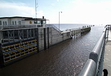
The St. Lucie Canal (C-44) is a man-made canal built in 1916 in Martin County, Florida to divert floodwaters from Lake Okeechobee via the canal to the South Fork of the St. Lucie River and into the St. Lucie Estuary, a component of the Indian River Lagoon, which connects to the Atlantic Ocean. Resulting from this connection, restoration projects in the St. Lucie River are the northernmost component of the Comprehensive Everglades Restoration Plan.
The Lake Okeechobee Scenic Trail (LOST) is a 109-mile multi-use path around Lake Okeechobee, the seventh largest lake in the United States and the largest in the state of Florida. The trail began as the Okeechobee Segment of the Florida National Scenic Trail (FNST), a 1,000 mile trail that runs from Miami to Pensacola. The USDA and National Forest Service dedicated the Okeechobee Segment as part of the FNST in 1993. Most of the trail is atop the 35-feet tall Herbert Hoover Dike. The trail crosses five counties, Hendry, Glades, Okeechobee, Martin and Palm Beach. Many stretches run along state and county highways, including Florida State Road 78.