Port of Iloilo

Last updated
Port of Iloilo
Pantalan ng Iloilo
Puerto sang Iloilo
Iloilo International Port (Lapuz, Iloilo City; 10-22-2022) (cropped).jpg
Visayas Container Terminal (Iloilo International Port)
Port of Iloilo
Click on the map for a fullscreen view
Location
Country Philippines
Location
Coordinates 10°41′24″N122°34′59″E / 10.69000°N 122.58306°E / 10.69000; 122.58306
UN/LOCODE PHILO [1]
Details
OpenedSeptember 29, 1855
Operated by Philippine Ports Authority
Owned by Iloilo City
Type of harbour Natural/Artificial
Size20.8 hectares (Iloilo International Port and Iloilo Domestic Port)
No. of wharfs 3
No. of piers 2
Hub For Negros Navigation (folded to 2GO Travel)
Statistics
Vessel arrivals78,679(2023) [2]
Annual cargo tonnage 4,038,984(2023) [2]
Annual container volume150,889 TEU (2023) [2]
Passenger traffic7,566,772(2023) [2]
Website
www.ppa.com.ph

The Port of Iloilo (Spanish: Puerto de Iloilo) is a seaport located in Iloilo City, Philippines. It serves the city, province of Iloilo, and the entire island of Panay in the Western Visayas region of the Philippines. It is located away from the older port facilities in Iloilo City Proper, on the southeastern coast of Panay, in Iloilo Strait, and one of the country’s safest and most natural harbors. [3]

Contents

It is one of the busiest ports in the country, recording 78,679 ship calls, 4 million metric tons in cargo throughput, and 7.6 million passengers in 2023. [4]

History

Aerial view of the Muelle Loney Wharf on the Iloilo River Iloilo Harbor, KITLV 1402344.tiff
Aerial view of the Muelle Loney Wharf on the Iloilo River

The Port of Iloilo has been a hub for international shipping since 1855, facilitating the export of sugar and fertilizer to global markets. Its opening to the world market on September 29, 1855, by Queen Isabella II of Spain, [5] [6] revitalized the local economy following the decline of the textile industry. With the inauguration of the Suez Canal in 1869, trade with Europe, particularly the United Kingdom, became more accessible. Nicholas Loney, the U.K. consul, played a pivotal role in this development, and Muelle Loney, the quay along the Iloilo River, is named in his honor.

The rise of the sugar industry spurred an economic boom in Iloilo and its neighboring island, Negros. Iloilo emerged as a leading center of commerce and trade in the Visayas and Mindanao, second only to Manila. [7] Serving as the primary deep-water port for both Iloilo and Bacolod, the capital of Negros Occidental, located 35 miles away across the Guimaras Strait, [8] it handled nearly all sugar and rice trade from Negros during the late 19th and early 20th centuries. [8]

In 2024, International Container Terminal Services, Inc. (ICTSI) secured a 25-year concession deal to develop and manage the Iloilo Commercial Port Complex. As part of this agreement, ICTSI renamed the facility Visayas Container Terminal (VCT). [9] [10]

Location

The Iloilo harbor is situated within the Iloilo Strait, delineated to the north by a line extending from the Dumangas River across the Iloilo Strait to Navalas Point on Guimaras Island, and to the south by a line stretching from Lusaran Point on Guimaras Island to Surraga River in the municipality of San Joaquin on Panay Island. [3]

Profile

Visayas Container Terminal (VCT), formerly known as Iloilo Commercial Port Complex (ICPC) Iloilo International Port.jpg
Visayas Container Terminal (VCT), formerly known as Iloilo Commercial Port Complex (ICPC)

The Port of Iloilo, considered the primary trading hub and commercial center for Western Visayas, stands out as one of the safest natural seaports in the Philippines. [3] Spanning 20.8 hectares (51 acres) of reclaimed land, the Iloilo Commercial Port Complex boasts extensive facilities, including 11,400 square metres (123,000 sq ft) of operational space, complemented by an additional area of 97,000 square metres (1,040,000 sq ft), equipped with a crane, 348 metres (1,142 ft) of rails, roll-on-roll-off support, a 7,800-container freight station, and a 720-square-metre (7,800 sq ft) passenger shed. With berth dimensions of 400 metres (1,300 ft) in length, 26.26 metres (86.2 ft) in width, and a berthing depth of 10.50 metres (34.4 ft), the port complex caters to vessels navigating international routes.

Several shipping firms utilize the Port of Iloilo, such as Lorenzo Shipping Corporation, 2GO, Amigo Shipping Company, New Panay Shipping Company, Sulpicio Lines, and Trans-Asia Shipping Lines Inc. [3] Fast ferries operate on the Iloilo-Bacolod route eight times daily, while 2GO inter-island overnight ferries connect to Manila, Bacolod, Cebu, Zamboanga and Cagayan de Oro. Fiberglass-made ferries ply the Iloilo Strait to Guimaras throughout the day and offer special trips at night.

Roll-on/roll-off ferry service, or RO-RO, is available between Iloilo City and Guimaras, while the RO-RO to Negros departs from Dumangas, Iloilo, 20 kilometres (12 mi) northeast of Iloilo City.

In 2017 statistics record, the port ranks third in terms of ship calls, with 11,853 recorded, fourth in cargo throughput, totaling 491,719 million metric tons, and fourth in passenger traffic, serving 2.4 million passengers. [11] [12]


Shipping firms and destinations

Shipping LinesDestinations [13]
Cokaliong Shipping Lines Cebu
Montenegro Shipping Lines Cuyo, Palawan, Puerto Princesa
2GO Travel Bacolod, Cagayan de Oro, Manila
SuperCat Bacolod
Ocean Jet Bacolod
Weesam Express Bacolod
Trans-Asia Shipping Lines Cebu
FastCat Bacolod
Starlite Ferries Batangas

Facilities

The Port provides bunkering facilities, offered by Pilipinas Shell, Caltex Philippines Inc., Petrophil Corp, and Petroleum Corp. As a key port in Western Visayas, the Commercial Port Complex (now renamed as Visayas Container Terminal [14] ) sits on reclaimed land in Lapuz district and is equipped with modern infrastructure. [3]

Domestic Passenger Terminal Port of Iloilo Passenger Terminal (Fort San Pedro Drive, Iloilo City; 01-27-2023).jpg
Domestic Passenger Terminal
MV 2GO Masagana, Iloilo Domestic Port MV 2GO Masagana right side, Iloilo Port (Iloilo City; 01-25-2023).jpg
MV 2GO Masagana, Iloilo Domestic Port

The port is mainly divided into the following:

Statistics [12]
YearShip CallsContainer Volume (TEU)Cargo Tonnage (mT)Passengers
201511,224137,4633,347,6481,823,371
201612,307151,8173,574,5752,237,811
201712,592162,2903,758,4532,402,748
201813,315165,7593,984,6492,547,596
201919,162171,0254,130,0553,124,361
202014,990154,2343,768,9051,105,572
202149,458157,9534,208,4563,109,498
202263,093167,9624,446,2755,962,999
202378,679150,8894,038,9847,566,772

Data

Facility data for the Port of Iloilo [3]
Typem2
Old foreign pier17,000
River wharf68,000
Iloilo Commercial Port Complex208,000
Back-up area/commercial97,000
Operational area111,000

The Port of Iloilo also offers open storage facilities, data listed below:

Outdoor storage data for the Port of Iloilo [3]
Typem2
Old foreign pier open storage9,200
River wharf open storage8,682

See also

Related Research Articles

<span class="mw-page-title-main">Panay Gulf</span> Arm of the Sulu Sea between the Philippine islands of Panay and Negros

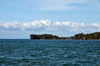
Panay Gulf is an extension of the Sulu Sea, reaching between the islands of Panay and Negros in the Philippines. The gulf contains the island-province of Guimaras and extends into the Iloilo Strait, between Panay and Guimaras, and into Guimaras Strait, between Guimaras and Negros. Guimaras Strait connects Panay Gulf with the Visayan Sea.

<span class="mw-page-title-main">Iloilo</span> Province in Western Visayas, Philippines

Iloilo, officially the Province of Iloilo, is a province in the Philippines located in the Western Visayas region. Its capital and largest city is Iloilo City, the regional center of Western Visayas. Iloilo occupies the southeast portion of the Visayan island of Panay and is bordered by the province of Antique to the west, Capiz to the north, the Jintotolo Channel to the northeast, the Guimaras Strait to the east, and the Iloilo Strait and Panay Gulf to the southwest.

<span class="mw-page-title-main">Guimaras</span> Province in Western Visayas, Philippines

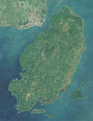
Guimaras, officially the Province of Guimaras, is an island province in the Philippines located in the Western Visayas region. The capital is Jordan, while the largest local government unit for it is the municipality of Buenavista. The province is situated in Panay Gulf, between the islands of Panay and Negros. To the northwest is the province of Iloilo and to the southeast is Negros Occidental. The whole island is part of the Metro IloiloGuimaras, one of the twelve metropolitan areas of the Philippines.

<span class="mw-page-title-main">Bacolod</span> Capital of Negros Occidental, Philippines

Bacolod, officially the City of Bacolod, is a 1st class highly urbanized city in the region of Western Visayas, Philippines. It is the capital of the province of Negros Occidental, where it is geographically situated but governed administratively independent.

<span class="mw-page-title-main">Western Visayas</span> Administrative region of the Philippines

Western Visayas is an administrative region in the Philippines, numerically designated as Region VI. It consists of six provinces and two highly urbanized cities. The regional center is Iloilo City. The region is dominated by the native speakers of four Visayan languages: Hiligaynon, Kinaray-a, Aklanon and Capiznon. The land area of the region is 20,794.18 km2 (8,028.68 sq mi), and with a population of 7,954,723 inhabitants, it is the second most populous region in the Visayas after Central Visayas.

<span class="mw-page-title-main">Buenavista, Guimaras</span> Municipality in Guimaras, Philippines

Buenavista, officially the Municipality of Buenavista, is a 2nd class municipality and the largest settlement in the province of Guimaras, Philippines. According to the 2020 census, it has a population of 52,899 people.

<span class="mw-page-title-main">Iloilo City</span> Capital of Iloilo, Philippines

Iloilo City, officially the City of Iloilo, is a 1st class highly urbanized city in the Western Visayas region of the Philippines, located on the southeastern coast of the island of Panay. It is the capital city of the province of Iloilo, where it is geographically situated and grouped under the Philippine Statistics Authority, but remains politically independent in terms of government and administration. In addition, it is the center of the Iloilo–Guimaras Metropolitan Area, as well as the regional center and primate city of the Western Visayas region. According to the 2020 census, Iloilo City has a population of 457,626 people. For the metropolitan area, the total population is 1,007,945 people.

<span class="mw-page-title-main">Dumangas</span> Municipality in Iloilo, Philippines

Dumangas, officially the Municipality of Dumangas, is a 1st class municipality in the province of Iloilo, Philippines. According to the 2020 census, it has a population of 73,899 people.

The Hiligaynon people, often referred to as Ilonggo people or Panayan people, are the second largest subgroup of the larger Visayan ethnic group, whose primary language is Hiligaynon, an Austronesian language of the Visayan branch native to Panay, Guimaras, and Negros. They originated in the province of Iloilo, on the island of Panay, in the region of Western Visayas. Over the years, inter-migrations and intra-migrations have contributed to the diaspora of the Hiligaynon to different parts of the Philippines. Today, the Hiligaynon, apart from the province of Iloilo, also form the majority in the provinces of Guimaras, Negros Occidental, Capiz, South Cotabato, Sultan Kudarat, and North Cotabato.

<span class="mw-page-title-main">Iloilo River</span> River in Western Visayas, Philippines

The Iloilo River is an estuary river located in the province of Iloilo, in Western Visayas, Philippines. The river starts in Oton at the Batiano estuary, then traverses through the Iloilo City districts of Lapuz, La Paz, Mandurriao, Molo, Arevalo and the City Proper, before emptying into the Iloilo Strait.

<span class="mw-page-title-main">Montenegro Lines</span> Batangas based shipping company

Montenegro Shipping Lines, Inc. (MSLI) is a Philippine domestic shipping line based at Batangas City, Philippines. The office is located at Montenegro Corporate office, along Bolbok Diversion Road, Bolbok Batangas City. It operates passenger, cargo and RORO vessels to various destinations in the Philippines under the brands Montenegro Lines and Marina Ferries.

<span class="mw-page-title-main">Philippine Nautical Highway System</span> Highway system in the Philippines

The Philippine Nautical Highway System, also the Road Roll-on/Roll-off Terminal System (RRTS) or simply the RoRo System, is an integrated network of highway and vehicular ferry routes which forms the backbone of a nationwide vehicle transport system in the Philippines. It is a system of roads and ports developed by the Philippine government to connect the major islands of Luzon, the Visayas and Mindanao. The 919-kilometer (571 mi) nautical highway was opened to the public on April 12, 2003 as the Strong Republic Nautical Highway (SRNH).

<span class="mw-page-title-main">Iloilo City Proper</span> District of Iloilo City, Philippines

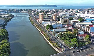
Iloilo City Proper is a district in Iloilo City, in the Western Visayas region of the Philippines. It holds great historical significance as the birthplace of modern-day Iloilo City and serves as a civic center, hosting the city and provincial government offices, as well as various local, provincial, and regional government establishments. The district also serves as the primary hub for financial institutions, with banks and other firms dispersed throughout its streets.

<span class="mw-page-title-main">Metro Iloilo–Guimaras</span> Metropolitan area in the Philippines

Metropolitan Iloilo–Guimaras, also shortened as Metro Iloilo–Guimaras or Metro Iloilo, or simply MIG, is a metropolitan area in the Western Visayas in the Philippines. It is situated on the southeastern coast of Panay, including the nearby island province of Guimaras, surrounded by the Iloilo and Guimaras straits.

<span class="mw-page-title-main">Lapuz, Iloilo City</span> District of Iloilo City, Philippines

Lapuz is a district in Iloilo City, in the Philippine province of Iloilo, on the island of Panay, in the Western Visayas region. It is the smallest district by land area as well as the least populous district, with 31,747 people in the 2020 census.

<span class="mw-page-title-main">Iloilo Strait</span> Strait in Western Visayas

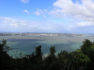
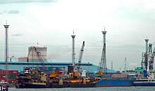
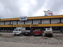
The Iloilo Strait is a strait in the Philippines that separates the islands of Panay and Guimaras in the Visayas, and connects Panay Gulf with the Guimaras Strait. It is the location of the Port of Iloilo, the third-busiest of the ports in the Philippines in number of ships. Iloilo City on Panay is the major city located on the strait with Buenavista and Jordan, both on Guimaras, immediately across the strait from the city. The Iloilo River empties into the strait.

<span class="mw-page-title-main">Guimaras Strait</span> Strait in Western Visayas

Guimaras Strait is a strait in the Western Visayas region of the Philippines, connecting the Visayan Sea with Panay Gulf and the Sulu Sea beyond. To the north and west are Panay and Guimaras Islands, while Negros Island is to the south and east. Bacolod City is a major seaport on the strait, which also provides access to the Port of Iloilo City via the Iloilo Strait.

<span class="mw-page-title-main">Batangas International Port</span> Port in Philippines

The Batangas International Port or locally known as the Batangas Pier is a seaport in Barangay Santa Clara, Batangas City primarily serving the Calabarzon region of the Philippines. The seaport covers an area of about 150 hectares.

<span class="mw-page-title-main">Port of General Santos</span> Port in Philippines

The Port of General Santos, also known as the Makar Port, is a seaport in General Santos in the Philippines.

<span class="mw-page-title-main">Districts of Iloilo City</span> Conglomeration of former cities and towns

Iloilo City is a conglomeration of former cities and towns in the Philippines, which are now the geographical or administrative districts (boroughs) composed of seven: Arevalo, City Proper, Jaro, La Paz, Lapuz, Mandurriao, and Molo. All administrative districts are divisions of the lone congressional district of Iloilo City, and each is composed of barangays (barrios), with a total of 180 city barangays.

References

  1. "UNLOCODE (PH) - PHILIPPINES". service.unece.org. Retrieved 26 April 2020.
  2. 1 2 3 4 "Statistics | Philippine Ports Authority Official Website". www.ppa.com.ph. Archived from the original on 2023-12-01. Retrieved 2024-04-26.
  3. 1 2 3 4 5 6 7 PORT OF ILOILO - General Information
  4. "Statistics | Philippine Ports Authority Official Website". www.ppa.com.ph. Retrieved 2024-04-26.
  5. Sonza, Demy. "The Port of Iloilo: 1855 - 2005". Graciano Lopez-Jaena Life and Works and Iloilo History Online Resource. Dr. Graciano Lopez-Jaena (DGLJ) Foundation. Archived from the original on 2016-01-19.
  6. Funtecha, Henry (2006-07-21). "Iloilo's position under colonial rule". thenewstoday.info. Retrieved 2019-07-29.
  7. Iloilo City - History Archived January 20, 2008, at the Wayback Machine
  8. 1 2 Linn, Brian McAllister (2000). The Philippine war 1899-1902. Lawrence, Kansas: University of Kansas. p. 73. ISBN   0-7006-1225-4.
  9. Chambers, Sam (2024-01-30). "ICTSI wins concession to develop Philippine box terminal". Splash247. Retrieved 2024-04-26.
  10. "ICTSI to develop Visayas Container Terminal in the Philippines" . Retrieved 2024-04-26.
  11. "Port of Iloilo Archives - Mac-Nels Vietnam - Your Cargo? Never say never" . Retrieved 2024-04-26.
  12. 1 2 "Statistics | Philippine Ports Authority Official Website". www.ppa.com.ph. Archived from the original on 2023-12-01. Retrieved 2024-04-26.
  13. PORT OF ILOILO - Destinations
  14. "Visayas Container Terminal | ICTSI". www.ictsi.com. Retrieved 2024-04-26.