
Spotsylvania County is a county in the U.S. state of Virginia. As of the July 2021 estimate, the population was 143,676. Its county seat is Spotsylvania Courthouse.
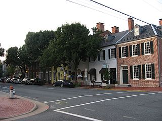
Fredericksburg is an independent city in Virginia, United States. As of the 2020 census, the population was 27,982. It is 48 miles (77 km) south of Washington, D.C., and 53 miles (85 km) north of Richmond. The Bureau of Economic Analysis of the United States Department of Commerce combines the city of Fredericksburg with neighboring Spotsylvania County for statistical purposes.

Caroline County is a United States county located in the eastern part of the Commonwealth of Virginia. The northern boundary of the county borders on the Rappahannock River, notably at the historic town of Port Royal. The Caroline county seat is Bowling Green.

Woodbridge is a census-designated place (CDP) in Prince William County, Virginia, United States, located 20 miles (32 km) south of Washington, D.C. Bounded by the Occoquan and Potomac rivers, Woodbridge had 44,668 residents at the 2020 census.
Red House is a small unincorporated community located in Putnam County in the U.S. state of West Virginia. The community is divided into two distinct areas: Red House (Proper) which follows the Kanawha River Valley along WV 62, and Red House Hill along WV 34 which is in the hills just off the Kanawha River Valley. The Red House Post Office is still in service and was founded on September 26, 1840. Some say the town was named for a red house which stood at the town site, while others believe nearby red rock formations account for the name.
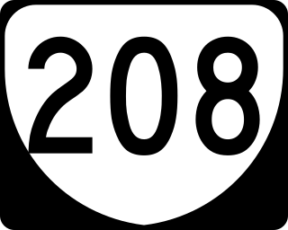
State Route 208 is a primary state highway in the U.S. state of Virginia. The state highway runs 47.35 miles (76.20 km) from U.S. Route 250 at Ferncliff east to US 1 and US 1 Business at Four Mile Fork. SR 208 is a major southwest–northeast highway through Louisa and Spotsylvania counties. The state highway connects the counties' respective seats of Louisa and Spotsylvania Courthouse, where the old route of the highway is SR 208 Business, with each other and with Fredericksburg near the highway's eastern terminus. SR 208 also has a direct connection with Interstate 64 (I-64) at Ferncliff and an indirect connection to I-95 near Fredericksburg.
Spotsylvania County Public Schools is a public school district serving Spotsylvania County, Virginia. It consists of 17 Elementary, 7 Middle, and 5 High Schools and has a total enrollment of nearly 24,000 students. The Spotsylvania County School division also has a Career and Technical Center and participates with other local school systems to offer the Commonwealth Governor's School. The district partners with area businesses to develop learning opportunities for the students. Spotsylvania County Public Schools works with the area Parks and Recreation Department to help maintain the area around the Schools.

Oak Hill is a suburban unincorporated community located in Fairfax County, Virginia, United States.
Leavells is an unincorporated community in Spotsylvania County in the U.S. state of Virginia.

Massaponax is an unincorporated community of Spotsylvania County, Virginia, United States. The name Massaponax comes from a native American village that existed before and during the early colonization of Virginia. It means "corn as tall as man".
Brockroad is an unincorporated community named after a local road in Spotsylvania County, Virginia, in the United States.
Bells Crossroad is an unincorporated community in Spotsylvania County, in the U.S. state of Virginia. This community is centered on the intersection of Stubbs Bridge Road and Lawyer's Road.
Belmont is an unincorporated community in Spotsylvania County, in the U.S. state of Virginia. It is marked with a highway sign at the intersection of Belmont Road and Orange Springs Road by the Virginia Department of Transportation, however is marked as being the intersection with Belmont Road and Jones Powell Road by the United States Geological Survey (USGS). The immediate area has Fletcher's Store and the Belmont Christmas Tree farm. Further south, there are other buildings identifying with Belmont, such as Belmont Baptist Church, the Belmont Ruritan Community Building where the Belmont Ruritan Club meets each evening at 7 p.m. and serves as the district's polling place for registered voters, and the Belmont Fire & Rescue station staffed by Spotsylvania County Volunteer Company 9.

Chancellor is an unincorporated community in Spotsylvania County, in the U.S. state of Virginia. Originally named Screamersville, the community was established as a railroad whistle stop west of Fredericksburg. The name was changed to Chancellor around 1927 by agreement of the railroad and the local community.

Five Mile Fork is an unincorporated community in Spotsylvania County, in the U.S. state of Virginia.

Granite Springs is an unincorporated community in Spotsylvania County, in the U.S. state of Virginia. It is marked by the United States Geological Survey (USGS) as the intersection of Belmont Road, Lawyers Road, and Granite Springs Road. Nearby, communities of Paytes, Virginia and Belmont border on the north and west, respectively, along with the Orange County line serving as a northwestern boundary, and Plentiful Creek forms the south and eastern boundaries.
Paytes is an unincorporated community in Spotsylvania County, in the U.S. state of Virginia. The community is marked at the intersection of Lawyer's Road and Catharpin Road by an electrical substation owned by Rappahannock Electric Co-op. A telecommunications tower was approved to be built on the site to expand cell coverage in the area on February 28, 2001.

Floris is a census-designated place (CDP) located within the Oak Hill area of Fairfax County, Virginia, United States. The population as of the 2010 census was 8,375.

Crosspointe is a census-designated place in Fairfax County, Virginia, United States. The population as of the 2020 census was 5,722.


