Related Research Articles

This is a list of properties and historic districts in Washington that are listed on the National Register of Historic Places. There are at least three listings in each of Washington's 39 counties.

This is a directory of properties and districts listed on the National Register of Historic Places in Wyoming. There are more than 500 listed sites in Wyoming. Each of the 23 counties in Wyoming has at least four listings on the National Register.

This is a list of properties and historic districts in Missouri on the National Register of Historic Places. There are NRHP listings in all of Missouri's 114 counties and the one independent city of St. Louis.

Millstone Bluff is a natural bluff in Pope County, Illinois, United States, located near the community of Glendale. Listed on the National Register of Historic Places because of its archaeological significance, Millstone Bluff is one of three National Register sites in Pope County, along with the Golconda Historic District and part of the Kincaid Mounds State Historic Site.

Herron–Morton Place is a historic district in Indianapolis, Indiana, dedicated to restoration and renewal. The boundaries of the neighborhood are East 16th Street on the south, East 22nd Street on the north, the alley west of North Pennsylvania on the west, and Central Avenue on the east.

The Bridger Trail, also known as the Bridger Road and Bridger Immigrant Road, was an overland route connecting the Oregon Trail to the gold fields of Montana. Gold was discovered in Virginia City, Montana in 1863, prompting settlers and prospectors to find a trail to travel from central Wyoming to Montana. In 1863, John Bozeman and John Jacobs scouted the Bozeman Trail, which was a direct route to the Montana gold fields through the Powder River Country. At the time the region was controlled by the Sioux, Cheyenne and Arapaho, who stepped up their raids in response to the stream of settlers along the trail.

Coso Rock Art District is a rock art site containing over 100,000 Petroglyphs by Paleo-Indians and/or Native Americans. The district is located near the towns of China Lake and Ridgecrest, California. Big and Little Petroglyph Canyons were declared a National Historic Landmark in 1964. In 2001, they were incorporated into this larger National Historic Landmark District. There are several other distinct canyons in the Coso Rock Art District besides the Big and Little Petroglyph Canyons. Also known as Little Petroglyph Canyon and Sand Tanks, Renegade Canyon is but one of several major canyons in the Coso Range, each hosting thousands of petroglyphs. The majority of the Coso Range images fall into one of six categories: bighorn sheep, entopic images, anthropomorphic or human-like figures, other animals, weapons & tools, and "medicine bag" images.

There is evidence of prehistoric human habitation in the region known today as the U.S. state of Wyoming stretching back roughly 13,000 years. Stone projectile points associated with the Clovis, Folsom and Plano cultures have been discovered throughout Wyoming. Evidence from what is now Yellowstone National Park indicates the presence of vast continental trading networks since around 1000 years ago. The Union Pacific Railroad played a central role in the European settlement of the area. Wyoming became a U.S. territory in 1868 and became the 44th U.S. state in 1890. It was the first state to grant women the right to vote, in 1869.
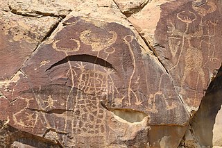
Legend Rock Petroglyph Site is located in Hot Springs County, Wyoming, 20 miles northwest of Hot Springs State Park. Legend Rock is a petroglyph site which features hundreds of individual petroglyphs spread across the face of the rock. Although a handful of the rock's etchings have variously been eroded and defaced, a wide majority have been preserved for public viewing. The nearly 300 individual petroglyphs feature some of the oldest and best examples of Dinwoody rock art in the world. The origins of the petroglyphs are still subject to debate. The site was listed on the National Register of Historic Places on July 5, 1973. and it is preserved by the state of Wyoming as a state historic site.

The following is an alphabetical list of articles related to the U.S. state of Wyoming.

Wyoming is a village and census-designated place on the Wood River in southern Rhode Island, primarily in the town of Richmond, Rhode Island, but extending north across the river into the town of Hopkinton, Rhode Island. The population was 270 at the 2010 census. It is the site of the Wyoming Village Historic District and a post office assigned ZIP code 02898.

This is a list of the National Register of Historic Places listings in Big Horn County, Wyoming.

Names Hill is a bluff located on the bank of the Green River in the U.S. state of Wyoming, where travelers on the Oregon and California trails carved their names into the rock. It is one of three notable "recording areas" along the emigrant trails in Wyoming along with Register Cliff and Independence Rock. The site was listed on the National Register of Historic Places on April 16, 1969.

Teapot Rock, also known as Teapot Dome, is a distinctive sedimentary rock formation in Natrona County, Wyoming that lent its name to a nearby oil field that became notorious as the focus of the Teapot Dome scandal, a bribery scandal during the presidential administration of Warren G. Harding. The site was listed on the National Register of Historic Places in 1974.

The Downtown Rock Springs Historic District is a 15.97-acre (6.46 ha) historic district that was listed on the National Register of Historic Places in 1994. It is roughly bounded by K, 4th, C, 2nd, A, and 5th Streets in downtown Rock Springs, Wyoming.

The Powder River Crossing, officially known as Powder River Station-Powder River Crossing , is an abandoned settlement located on the east bank of the Powder River in southeast Johnson County about twenty-four miles east of Kaycee, Wyoming. It developed after a wooden toll bridge was built across the Powder River in 1877, at a site that was originally used as a ford. With crossing secured, a settlement developed here in the late 19th century, incorporating a stage stop on the Bozeman Trail. The site is notable for having well-preserved wagon ruts from the pioneer era.

Petroglyph Canyon (24CB601) is an archaeologically significant canyon in the northwestern United States. Located on both sides of the border between Montana and Wyoming, the canyon has long been obscure due to its small size. However, it gained substantial attention in the late 20th century because of its numerous prehistoric petroglyphs, and much of it was named a historic site in the 1970s.
Aiken's Wash is an archaeologically and geologically significant wash located in the Mojave National Preserve in San Bernardino County, California. The wash includes several pictograph and petroglyph sites dating from the late pre-Columbian period. The proximity of pictographs and petroglyphs is unusual in the Mojave Desert region. The area was added to the National Register of Historic Places as the Aiken's Wash National Register District. The district comprises 1,450 acres (590 ha), including all major archaeological sites in the wash.
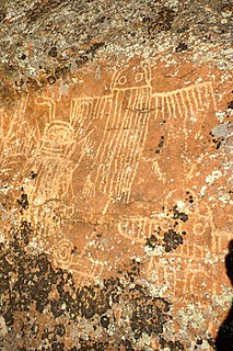
The Torrey Lake Petroglyph District extends for about 3.2 miles (5.1 km) along Torrey Creek in Fremont County, Wyoming. The site includes about 175 petroglyphs, as well as eleven lithic scatters and a sheep trap. The petroglyphs are in the Interior Line Style, or Dinwoody style, consistent with other rock art in central Wyoming. Site investigations have uncovered a number of petroglyphs that had previously been hidden under lichen. The site was placed on the National Register of Historic Places on October 4, 1993.
References
- ↑ "National Register Information System". National Register of Historic Places . National Park Service. July 9, 2010.
- ↑ "Powder Wash Archaeological District". Wyoming State Historic Preservation Office.
- ↑ "Wyoming Aims to Protect Indian Rock Art". Billings Gazette. January 25, 2014.