
The Ohio River is a 981-mile (1,579 km) long river in the United States. It is located in the Midwestern and Southern United States, flowing southwesterly from western Pennsylvania south of Lake Erie to its mouth on the Mississippi River at the southern tip of Illinois. It is the third largest river by discharge volume in the United States and the largest tributary by volume of the north-south flowing Mississippi River that divides the eastern from western United States. The river flows through or along the border of six states, and its drainage basin includes parts of 14 states. Through its largest tributary, the Tennessee River, the basin includes several states of the southeastern U.S. It is the source of drinking water for three million people.

West Virginia is a state in the Appalachian, Mid-Atlantic and Southeastern regions of the United States. It is bordered by Pennsylvania to the northeast, Maryland to the east and northeast, Virginia to the southeast, Kentucky to the southwest, and Ohio to the northwest. West Virginia is the 41st-largest state by area and ranks 38th in population, with a population of 1,795,045 residents. The capital and largest city is Charleston.

Charleston is the capital and most populous city of the U.S. state of West Virginia. Located at the confluence of the Elk and Kanawha rivers, the city had a population of 51,400 at the 2010 census and an estimated population of 46,536 in 2019. The Charleston metropolitan area as a whole had an estimated 208,089 residents in 2019. Charleston is the center of government, commerce, and industry for Kanawha County, of which it is the county seat.

The Potomac River is found within the Mid-Atlantic region of the United States and flows from the Potomac Highlands into the Chesapeake Bay. The river is approximately 405 miles (652 km) long, with a drainage area of about 14,700 square miles (38,000 km2). In terms of area, this makes the Potomac River the fourth largest river along the East Coast of the United States and the 21st largest in the United States. Over 5 million people live within the Potomac watershed.

Cabell County is located in the U.S. state of West Virginia. As of the 2010 census, the population was 96,319, making it West Virginia's fourth-most populous county. Its county seat is Huntington. The county was organized in 1809 and named for William H. Cabell, the Governor of Virginia from 1805 to 1808. Cabell County is part of the Huntington-Ashland, WV-KY-OH Metropolitan Statistical Area.

Warren County is a county located in the northeastern Piedmont region of the U.S. state of North Carolina, on the northern border with Virginia. As of the 2010 Census, the population was 20,972. Its county seat is Warrenton. It was a center of tobacco and cotton plantations, education, and later textile mills.

Bertie County is a county located in the northeast area of the U.S. state of North Carolina. As of the 2010 census, the population was 21,282. Its county seat is Windsor. The county was created in 1722 as Bertie Precinct and gained county status in 1739.

Madison County is a county located in the U.S. state of Illinois. It is a part of the Metro East in southern Illinois. According to the 2010 census, it had a population of 269,282. The county seat is Edwardsville, Illinois, and the largest city is Granite City, Illinois.

Hempstead County is a county located in the U.S. state of Arkansas. As of the 2010 census, the population was 22,609. The county seat is Hope. Hempstead County is Arkansas's fourth county, formed on December 15, 1818, alongside Clark and Pulaski counties. The county is named for Edward Hempstead, a delegate to the U.S. Congress from the Missouri Territory, which included present-day Arkansas at the time. It is an alcohol prohibition or dry county.

Romney is a city in and the county seat of Hampshire County, West Virginia, United States. The population was 1,848 at the 2010 census.
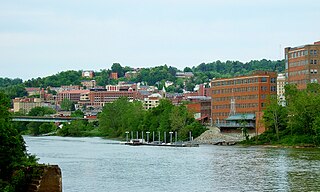
Morgantown is the county seat of Monongalia County, West Virginia, United States, situated along the Monongahela River. West Virginia University is located in the city. The population was 29,660 at the 2010 Census Bureau, making Morgantown the largest city in North-Central West Virginia. The Morgantown metropolitan area has a population of 138,176.

Wheeling is a city in Ohio and Marshall counties in the U.S. state of West Virginia. Located almost entirely in Ohio County, of which it is the county seat, it lies along the Ohio River in the foothills of the Appalachian Mountains. Wheeling was originally a settlement in the British colony of Virginia, and later the second largest city in the Commonwealth of Virginia. Wheeling was where creation of West Virginia was planned, and it was the first capital of the new state. Due to its location along major transportation routes, including the Ohio River, National Road, and the B&O Railroad, Wheeling became a manufacturing center in the late nineteenth century. After experiencing the closing of factories and substantial population loss following World War II, Wheeling's major industries now include healthcare, education, law and legal services, entertainment and tourism, and energy.

The Shenandoah Valley is a geographic valley and cultural region of western Virginia and the Eastern Panhandle of West Virginia in the United States. The valley is bounded to the east by the Blue Ridge Mountains, to the west by the eastern front of the Ridge-and-Valley Appalachians, to the north by the Potomac River and to the south by the James River. The cultural region covers a larger area that includes all of the valley plus the Virginia highlands to the west, and the Roanoke Valley to the south. It is physiographically located within the Ridge and Valley province and is a portion of the Great Appalachian Valley.
West Virginia University (WVU) is a public, land-grant, research university with its main campus in Morgantown, West Virginia. Its other campuses are those of the West Virginia University Institute of Technology in Beckley, Potomac State College of West Virginia University in Keyser, and a second clinical campus for the university's medical and dental schools at Charleston Area Medical Center in Charleston. WVU Extension Service provides outreach with offices in all of West Virginia's 55 counties.

The Monongahela River —often referred to locally as the Mon —is a 130-mile-long (210 km) river on the Allegheny Plateau in north-central West Virginia and southwestern Pennsylvania. The river flows from the confluence of its west and east forks in north-central West Virginia northeasterly into southwestern Pennsylvania, then northerly to Pittsburgh and its confluence with the Allegheny River to form the Ohio River. The river's entire length is navigable via a series of locks and dams.
The Huntington–Ashland metropolitan area is a metropolitan area in the Appalachian Plateau region of the United States. Referred to locally as the “Tri-State area”, the region spans seven counties in the three states of West Virginia, Kentucky, and Ohio. With a population of 361,580, the Tri-State area is nestled along the banks of the Ohio River. The region offers a diverse range of outdoor activities.
Prairietown may refer to:
Arkansas Highway 174 is a designation for a state highway in Southwest Arkansas. The route is split into two sections. The first section begins at AR 355 in Spring Hill and ends at US Route 67 (US 67) in Hope. The second section begins at US 67 in Perrytown and ends at AR 299 just south of Interstate 30 (I-30). AR 174 is one of the few exceptions to the rule of an even-numbered state highway traveling north to south, rather than east to west.


