Prathersville, Missouri

Last updated

Prathersville, Missouri
Clay County Missouri Incorporated and Unincorporated areas Prathersville Highlighted.svg
Location of Prathersville, Missouri
Coordinates: 39°18′55″N94°16′26″W / 39.31528°N 94.27389°W / 39.31528; -94.27389
Country United States
State Missouri
County Clay
Area
[1]
  Total2.25 sq mi (5.83 km2)
  Land2.25 sq mi (5.83 km2)
  Water0.00 sq mi (0.00 km2)
Elevation
[2]
768 ft (234 m)
Population
 (2020)
  Total121
  Density53.73/sq mi (20.75/km2)
Time zone UTC-6 (Central (CST))
  Summer (DST) UTC-5 (CDT)
FIPS code 29-59816 [3]
GNIS feature ID2399021 [2]

Prathersville is a village in Clay County, Missouri, United States. The population was 121 at the 2020 census. [4] It is part of the Kansas City metropolitan area.

Contents

History

A post office called Prathersville was established in 1876, and remained in operation until 1904. [5] The village was named after J. A. Prather, the proprietor of a local mill. [6]

Geography

According to the United States Census Bureau, the village has a total area of 2.26 square miles (5.85 km2), all land. [7]

Demographics

Historical population
CensusPop.Note
1880 70
1960 148
1970 1533.4%
1980 141−7.8%
1990 130−7.8%
2000 111−14.6%
2010 12411.7%
2020 121−2.4%
U.S. Decennial Census [8]

2010 census

As of the census [9] of 2010, there were 124 people, 56 households, and 34 families living in the village. The population density was 54.9 inhabitants per square mile (21.2/km2). There were 61 housing units at an average density of 27.0 per square mile (10.4/km2). The racial makeup of the village was 95.2% White, 1.6% Native American, 0.8% Asian, 0.8% from other races, and 1.6% from two or more races. Hispanic or Latino of any race were 2.4% of the population.

There were 56 households, of which 21.4% had children under the age of 18 living with them, 58.9% were married couples living together, 1.8% had a female householder with no husband present, and 39.3% were non-families. 35.7% of all households were made up of individuals, and 21.4% had someone living alone who was 65 years of age or older. The average household size was 2.21 and the average family size was 2.88.

The median age in the village was 51.3 years. 15.3% of residents were under the age of 18; 4.8% were between the ages of 18 and 24; 19.4% were from 25 to 44; 44.5% were from 45 to 64; and 16.1% were 65 years of age or older. The gender makeup of the village was 50.8% male and 49.2% female.

2000 census

As of the census [3] of 2000, there were 111 people, 47 households, and 33 families living in the village. The population density was 49.6 inhabitants per square mile (19.2/km2). There were 51 housing units at an average density of 22.8 per square mile (8.8/km2). The racial makeup of the village was 98.20% White, and 1.80% from two or more races.

There were 47 households, out of which 29.8% had children under the age of 18 living with them, 70.2% were married couples living together, and 27.7% were non-families. 25.5% of all households were made up of individuals, and 17.0% had someone living alone who was 65 years of age or older. The average household size was 2.36 and the average family size was 2.79.

In the village, the population was spread out, with 19.8% under the age of 18, 8.1% from 18 to 24, 29.7% from 25 to 44, 19.8% from 45 to 64, and 22.5% who were 65 years of age or older. The median age was 42 years. For every 100 females, there were 98.2 males. For every 100 females age 18 and over, there were 89.4 males.

The median income for a household in the village was $34,063, and the median income for a family was $37,500. Males had a median income of $47,917 versus $28,125 for females. The per capita income for the village was $20,745. There were no families and 4.0% of the population living below the poverty line, including no under eighteens and 5.1% of those over 64.

Related Research Articles

<span class="mw-page-title-main">River Bend, Missouri</span> Village in Missouri, United States

River Bend is a village in Jackson County, Missouri, United States. The population was 3 at the 2020 census. It is the only part of Jackson County that lies north of the Missouri River. In 1951, the Missouri River was relocated to a new channel, creating River Bend,. The county line still follows the original riverbed. It is part of the Kansas City metropolitan area. The mayor is Alex Dockler.

<span class="mw-page-title-main">Airport Drive, Missouri</span> Village in Missouri, United States

Airport Drive is a village in Jasper County, Missouri, United States. The population was 766 at the 2020 census. It is part of the Joplin, Missouri Metropolitan Statistical Area. The community is still commonly referred to as "Stone's Corner," as the intersection of Route 43 and Route 171 is known.

<span class="mw-page-title-main">Evergreen, Missouri</span> Village in Missouri, United States

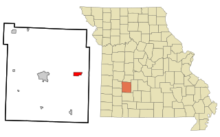
Evergreen is a village in Laclede County, Missouri, United States. The population was 28 at the 2010 census. It was named Twin Bridges at the 2000 census.

<span class="mw-page-title-main">Flemington, Missouri</span> Village in Missouri, United States

Flemington is a village in Polk County, Missouri, United States. The population was 148 at the 2010 census. It is part of the Springfield, Missouri Metropolitan Statistical Area.

<span class="mw-page-title-main">Halfway, Missouri</span> Village in Missouri, United States

Halfway is a village in Polk County, Missouri, United States. According to the 2010 census, the population of Halfway is 173. It is part of the Springfield, Missouri Metropolitan Statistical Area.

<span class="mw-page-title-main">Rensselaer, Missouri</span> Village in Missouri, United States

Rensselaer is a village in Ralls County, Missouri, United States. The population was 253 at the 2020 census. It is part of the Hannibal Micropolitan Statistical Area.

<span class="mw-page-title-main">Collins, Missouri</span> Village in Missouri, United States

Collins is a village in St. Clair County, Missouri, United States. The population was 125 at the 2020 census.

<span class="mw-page-title-main">Roscoe, Missouri</span> Village in Missouri, United States

Roscoe is a village in St. Clair County, Missouri, United States. The population was 89 at the 2020 census.

<span class="mw-page-title-main">Country Life Acres, Missouri</span> Village in Missouri, United States

Country Life Acres is a village in St. Louis County, Missouri, United States. The population was 72 at the 2020 census.

<span class="mw-page-title-main">Glen Echo Park, Missouri</span> Former Village in Missouri, United States

Glen Echo Park was a village in St. Louis County, Missouri, United States. The population was 122 at the 2020 census. The community took its name from the nearby Glen Echo Country Club.

<span class="mw-page-title-main">Grantwood Village, Missouri</span> Town in Missouri, United States

Grantwood Village is a town in St. Louis County, Missouri, United States. The population was 863 at the 2010 census.

<span class="mw-page-title-main">Marlborough, Missouri</span> Village in Missouri, United States

Marlborough is a village in St. Louis County, Missouri, United States. The population was 2,179 at the 2010 census.

<span class="mw-page-title-main">Norwood Court, Missouri</span> Village in Missouri, United States

Norwood Court is a village in St. Louis County, Missouri, United States. The population was 959 at the 2010 census.

<span class="mw-page-title-main">Pasadena Park, Missouri</span> Village in Missouri, United States

Pasadena Park is a village in St. Louis County, Missouri, United States. The population was 470 at the 2010 census. It is part of the Normandy School District, and is distinct from the city of Pasadena Hills.

<span class="mw-page-title-main">Sycamore Hills, Missouri</span> Village in Missouri, United States

Sycamore Hills is a village in St. Louis County, Missouri, United States. The population is 560 at the 2020 census.

<span class="mw-page-title-main">Westwood, Missouri</span> Village in Missouri, United States

Westwood is a village in west St. Louis County, Missouri, United States. The population was 316 at the 2020 census.

<span class="mw-page-title-main">Wilbur Park, Missouri</span> Village in Missouri, United States

Wilbur Park is a village in St. Louis County, Missouri, United States. The population was 439 at the 2020 census.

<span class="mw-page-title-main">Harwood, Missouri</span> Village in Missouri, United States

Harwood is a village in northeast Vernon County, Missouri, United States. The population was 47 at the 2010 census. It was estimated to be 45 by the City of Harwood as of July 1, 2019.

<span class="mw-page-title-main">Uplands Park, Missouri</span> Village in Missouri, United States

Uplands Park is a village in St. Louis County, Missouri, United States. The population was 445 at the 2010 census. The village is one of many small majority black communities located in the Natural Bridge corridor of mid-St. Louis County, characterized by small homes on small lots.

<span class="mw-page-title-main">Ionia, Missouri</span> Village in Missouri, United States

Ionia is a village in northern Benton and southern Pettis counties in the U.S. state of Missouri. The population was 88 at the 2010 census.

References

  1. "ArcGIS REST Services Directory". United States Census Bureau. Retrieved August 28, 2022.
  2. 1 2 U.S. Geological Survey Geographic Names Information System: Prathersville, Missouri
  3. 1 2 "U.S. Census website". United States Census Bureau . Retrieved January 31, 2008.
  4. "Explore Census Data". data.census.gov. Retrieved December 27, 2021.
  5. "Clay County Place Names, 1928–1945 (archived)". The State Historical Society of Missouri. Archived from the original on June 24, 2016. Retrieved September 21, 2016.{{cite web}}: CS1 maint: bot: original URL status unknown (link)
  6. "Clay County Place Names, 1928–1945 (archived)". The State Historical Society of Missouri. Archived from the original on June 24, 2016. Retrieved September 19, 2016.{{cite web}}: CS1 maint: bot: original URL status unknown (link)
  7. "US Gazetteer files 2010". United States Census Bureau. Archived from the original on January 25, 2012. Retrieved July 8, 2012.
  8. "Census of Population and Housing". Census.gov. Retrieved June 4, 2015.
  9. "U.S. Census website". United States Census Bureau . Retrieved July 8, 2012.