
The Karoo is a semi-desert natural region of South Africa. No exact definition of what constitutes the Karoo is available, so its extent is also not precisely defined. The Karoo is partly defined by its topography, geology and climate, and above all, its low rainfall, arid air, cloudless skies, and extremes of heat and cold. The Karoo also hosted a well-preserved ecosystem hundreds of million years ago which is now represented by many fossils.
Beaufort West Local Municipality is a municipality located in Western Cape Province, South Africa. As of 2011 the population is 49,586. Its municipality code is WC053.

Oudtshoorn Municipality is a municipality located in the Western Cape Province of South Africa. As of 2011, the population was 95,933.

The Central Karoo District Municipality is a district municipality located in the Western Cape Province of South Africa. Its municipality code is DC5.

Kannaland Municipality is a local municipality located within the Garden Route District Municipality in the Western Cape province of South Africa. The municipal area is situated in the western part of the Little Karoo and includes the towns of Ladismith, Calitzdorp and Zoar. As of 2011 it has a population of 24,767. Its municipality code is WC041.

Laingsburg Municipality is a municipality located in the Western Cape Province of South Africa. As of 2011 the population is 8,289. Its municipality code is WC051.

Oudtshoorn, the "ostrich capital of the world", is a town in the Western Cape province of South Africa, located between the Swartberg mountains to the north and the Outeniqua Mountains to the south. Two ostrich-feather booms, during 1865–1870 and 1900–1914, truly established the settlement. With approximately 60,000 inhabitants, it is the largest town in the Little Karoo region. The town's economy is primarily reliant on the ostrich farming and tourism industries. Oudtshoorn is home to the world's largest ostrich population, with a number of specialised ostrich breeding farms, such as the Safari Show Farm and the Highgate Ostrich Show Farm.

The Swartberg mountains are a mountain range in the Western Cape province of South Africa. It is composed of two main mountain chains running roughly east–west along the northern edge of the semi-arid Little Karoo. To the north of the range lies the other large semi-arid area in South Africa, the Great Karoo. Most of the Swartberg Mountains are above 2000 m high, making them the tallest mountains in the Western Cape. It is also one of the longest, spanning some 230 km from south of Laingsburg in the west to between Willowmore and Uniondale in the east. Geologically, these mountains are part of the Cape Fold Belt.

Laingsburg is a town located in the Western Cape province in South Africa. It is a relatively large agricultural town in the semi-arid Great Karoo. It was partially destroyed in a flash flood in 1981.

Municipal elections were held in South Africa on 1 March 2006, to elect members to the local governing councils in the municipalities of South Africa. The municipalities form the local government of South Africa and are subdivisions of the provinces, thus making them responsible for local service delivery, such as electricity, water and fire services.
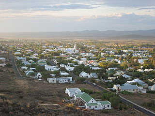
Prince Albert is a small town in the Western Cape in South Africa. It is located on the southern edge of the Great Karoo, at the foot of the Swartberg mountains. In recent years the moniker the "Franschhoek of the Karoo" has been used to describe the town's appeal to the art community and wealthier South Africans, many of whom have become residents of the town.
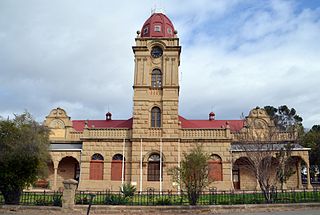
The CP Nel Museum is a museum in Oudtshoorn, South Africa, which houses exhibits depicting the role of the ostrich trade in the town's history, as well as the cultural history and lifestyle of the people of the Little Karoo region, as it was during the Victorian era and early 20th century.
The Western Cape province of South Africa is governed in a parliamentary system in which the people elect the Provincial Parliament, and the parliament elects the Premier as head of the executive. The Premier leads a cabinet of provincial ministers overseeing various executive departments. The provincial government is subject to the Constitution of the Western Cape and the Constitution of South Africa, which together form the supreme law of the province.

Calitzdorp is a town on the Western side of the Little or Klein Karoo in the Western Cape Province of South Africa and lies on South Africa's Route 62.
Port Elizabeth railway station is a railway station, located in Port Elizabeth, South Africa.
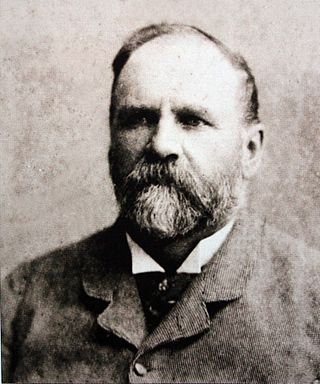
Thomas Charles John Bain was a South African road engineer. As a prolific road building pioneer, Bain was responsible for the planning and construction of more than 900 km of roads and mountain passes, many of them still in use today, over a career spanning from 1848 until 1888. These passes through the mountain ranges between the thin coastal plain and the interior of the former Cape Colony in South Africa, played a major role in opening up the vast hinterland of South Africa.

De Doorns is situated in the Breede Valley Local Municipality, Cape Winelands District Municipality in the Western Cape province of South Africa.

Touws River is a small railway town of 6,800 people in the Western Cape province of South Africa. It is located on the river of the same name, about 160 kilometres (100 mi) north-east of Cape Town. The Touwsrivier CPV Solar Project is located just outside of the town and supplies 50 MW to the national electrical grid.

Matjiesfontein is a settlement in Central Karoo District Municipality in the Western Cape province of South Africa.

Leeu-Gamka is a small town in the Western Cape province of South Africa, located 355 kilometres (221 mi) north-east of Cape Town in the Karoo.


