Prospecting

Last updated
Prospector and burro, western Colorado, USA, c. 1900 Prospector&Burro.jpg
Prospector and burro, western Colorado, USA, c.1900
Schoolchildren learn to pan for gold, Denver, 1972 THE DENVER P.T.A. SPONSORED A WEEK-LONG ECOLOGY WORKSHOP TO INTRODUCE SCHOOL CHILDREN TO THE NATURAL ENVIRONMENT.... - NARA - 543681.jpg
Schoolchildren learn to pan for gold, Denver, 1972
Rich specimen from a 2009 gold discovery by a prospector in southeastern Yukon Territory. The gold, deposited along a fracture, appears rusty-orange in this photo. Yukon Gold Discovery.jpg
Rich specimen from a 2009 gold discovery by a prospector in southeastern Yukon Territory. The gold, deposited along a fracture, appears rusty-orange in this photo.

Prospecting is the first stage of the geological analysis (followed by exploration) of a territory. It is the search for minerals, fossils, precious metals, or mineral specimens. It is also known as fossicking.

Contents

Traditionally prospecting relied on direct observation of mineralization in rock outcrops or in sediments. Modern prospecting also includes the use of geologic, geophysical, and geochemical tools to search for anomalies which can narrow the search area. Once an anomaly has been identified and interpreted to be a potential prospect direct observation can then be focused on this area. [1]

In some areas a prospector must also stake a claim, meaning they must erect posts with the appropriate placards on all four corners of a desired land they wish to prospect and register this claim before they may take samples. In other areas publicly held lands are open to prospecting without staking a mining claim. [2] [ citation needed ]

Historical methods

Example of a prospecting pickaxe. Prospecting Pickaxe with rock.jpg
Example of a prospecting pickaxe.

The traditional methods of prospecting involved combing through the countryside, often through creek beds and along ridgelines and hilltops, often on hands and knees looking for signs of mineralization in the outcrop. In the case of gold, all streams in an area would be panned at the appropriate trap sites looking for a show of 'colour' or gold in the river trail.

Once a small occurrence or show was found, it was then necessary to intensively work the area with pick and shovel, and often via the addition of some simple machinery such as a sluice box, races and winnows, to work the loose soil and rock looking for the appropriate materials (in this case, gold). For most base metal shows, the rock would have been mined by hand and crushed on site, the ore separated from the gangue by hand.

These shows were commonly short-lived, exhausted and abandoned quite soon, requiring the prospector to move onwards to the next and hopefully bigger and better show. Occasionally, the prospector would strike it rich and be joined by other prospectors to develop a larger-scale mining operation. Although these are thought of as "old" prospecting methods, these techniques are still used today, but usually coupled with more advanced techniques such as geophysical magnetic or gravity surveys.

In most countries in the 19th and early 20th century, it was very unlikely that a prospector would retire rich even if he was the one who found the greatest of lodes. For instance Patrick (Paddy) Hannan, who discovered the Golden Mile, Kalgoorlie, died without receiving anywhere near a fraction of the value of the gold contained in the lodes.[ clarification needed ][ citation needed ] The same story repeated at Bendigo, Ballarat, Klondike and California.

The gold rushes

In the United States and Canada, prospectors were lured by the promise of gold, silver, and other precious metals. They traveled across the mountains of the American West, carrying picks, shovels and gold pans. The majority of early prospectors had no training and relied mainly on luck to discover deposits.

Other gold rushes occurred in Papua New Guinea, Australia at least four times, Fiji, [3] South Africa and South America. In all cases, the gold rush was sparked by idle prospecting for gold and minerals which, when the prospector was successful, generated 'gold fever' and saw a wave of prospectors comb the countryside.

Modern prospecting

Modern prospectors today[ clarification needed ] rely on training, the study of geology, and prospecting technology.

Knowledge of previous prospecting in an area helps in determining location of new prospective areas. Prospecting includes geological mapping, rock assay analysis, and sometimes the intuition of the prospector.

Prospecting of minerals found in mobile fluids,[ clarification needed ] as is often the case of lithium, adds a "temporal element" to be considered. [4]

Metal detecting

Metal detectors are invaluable for gold prospectors, as they are quite effective at detecting gold nuggets within the soil down to around 1 metre (3 feet), depending on the acuity of the operator's hearing and skill.[ citation needed ]

Magnetic separators may be useful in separating the magnetic fraction of a heavy mineral sand from the nonmagnetic fraction, which may assist in the panning or sieving of gold from the soil or stream.

Prospecting pickaxe

Prospecting pickaxes are used to scrape at rocks and minerals, obtaining small samples that can be tested for trace amounts of ore. Modern prospecting pickaxes are also sometimes equipped with magnets, to aid in the gathering of ferromagnetic ores. Prospecting pickaxes are usually equipped with a triangular head, with a very sharp point.[ citation needed ][ clarification needed ]

Electromagnetic prospecting

The introduction of modern gravity and magnetic surveying methods has greatly facilitated the prospecting process. Airborne gravimeters and magnetometers can collect data from vast areas and highlight anomalous geologic features. [5] Three-dimensional inversions of audio-magnetotellurics (AMT) is used to find conductive materials up to a few kilometers into the Earth, which has been helpful to locate kimberlite pipes, as well as tungsten and copper. [6] [7]

Another relatively new prospecting technique is using low frequency electromagnetic (EM) waves for 'sounding' into the Earth's crust. These low frequency waves will respond differently based on the material they pass through, allowing for analysts to create three-dimensional images of potential ore bodies or volcanic intrusions. This technique is used for a variety of prospecting, but can mainly be for finding conductive materials. [8] So far these low frequency EM techniques have been proven for geothermal exploration as well as for coal bed methane analysis. [9] [10]

Geochemical prospecting

Geochemical prospecting involves analyzing the chemical properties of rock samples, drainage sediments, soils, surface and ground waters, mineral separates, atmospheric gases and particulates, and even plants and animals. Properties such as trace element abundances are analyzed systematically to locate anomalies. [11]

See also

Related Research Articles

<span class="mw-page-title-main">Mining</span> Extraction of valuable minerals or other geological materials from the Earth

Mining is the extraction of valuable geological materials and minerals from the surface of the Earth. Mining is required to obtain most materials that cannot be grown through agricultural processes, or feasibly created artificially in a laboratory or factory. Ores recovered by mining include metals, coal, oil shale, gemstones, limestone, chalk, dimension stone, rock salt, potash, gravel, and clay. The ore must be a rock or mineral that contains valuable constituent, can be extracted or mined and sold for profit. Mining in a wider sense includes extraction of any non-renewable resource such as petroleum, natural gas, or even water.

<span class="mw-page-title-main">Magnetometer</span> Device that measures magnetism

A magnetometer is a device that measures magnetic field or magnetic dipole moment. Different types of magnetometers measure the direction, strength, or relative change of a magnetic field at a particular location. A compass is one such device, one that measures the direction of an ambient magnetic field, in this case, the Earth's magnetic field. Other magnetometers measure the magnetic dipole moment of a magnetic material such as a ferromagnet, for example by recording the effect of this magnetic dipole on the induced current in a coil.

<span class="mw-page-title-main">Kimberlite</span> Igneous rock which sometimes contains diamonds

Kimberlite, an igneous rock and a rare variant of peridotite, is most commonly known to be the main host matrix for diamonds. It is named after the town of Kimberley in South Africa, where the discovery of an 83.5-carat diamond called the Star of South Africa in 1869 spawned a diamond rush and led to the excavation of the open-pit mine called the Big Hole. Previously, the term kimberlite has been applied to olivine lamproites as Kimberlite II, however this has been in error.

<span class="mw-page-title-main">Gold rush</span> Gold discovery triggering an onrush of miners seeking fortune

A gold rush or gold fever is a discovery of gold—sometimes accompanied by other precious metals and rare-earth minerals—that brings an onrush of miners seeking their fortune. Major gold rushes took place in the 19th century in Australia, Greece, New Zealand, Brazil, Chile, South Africa, the United States, and Canada while smaller gold rushes took place elsewhere.

<span class="mw-page-title-main">Geophysical survey (archaeology)</span> Non-invasive physical sensing techniques used for archaeological imaging or mapping

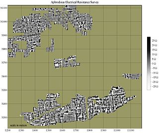
In archaeology, geophysical survey is ground-based physical sensing techniques used for archaeological imaging or mapping. Remote sensing and marine surveys are also used in archaeology, but are generally considered separate disciplines. Other terms, such as "geophysical prospection" and "archaeological geophysics" are generally synonymous.

<span class="mw-page-title-main">Economic geology</span> Science concerned with earth materials of economic value

Economic geology is concerned with earth materials that can be used for economic and industrial purposes. These materials include precious and base metals, nonmetallic minerals and construction-grade stone. Economic geology is a subdiscipline of the geosciences; according to Lindgren (1933) it is “the application of geology”. It may be called the scientific study of the Earth's sources of mineral raw materials and the practical application of the acquired knowledge.

A telluric current, or Earth current, is an electric current that flows underground or through the sea, resulting from natural and human-induced causes. These currents have extremely low frequency and traverse large areas near or at the Earth's surface. The Earth's crust and mantle are host to telluric currents, with around 32 mechanisms generating them, primarily geomagnetically induced currents caused by changes in the Earth's magnetic field due to solar wind interactions with the magnetosphere or solar radiation's effects on the ionosphere. These currents exhibit diurnal patterns, flowing towards the Sun during the day and towards the poles at night.

<span class="mw-page-title-main">Mining engineering</span> Engineering discipline

Mining in the engineering discipline is the extraction of minerals from the ground. Mining engineering is associated with many other disciplines, such as mineral processing, exploration, excavation, geology, metallurgy, geotechnical engineering and surveying. A mining engineer may manage any phase of mining operations, from exploration and discovery of the mineral resources, through feasibility study, mine design, development of plans, production and operations to mine closure.

<span class="mw-page-title-main">Sudbury Basin</span> Third largest verified astrobleme on earth, remains of an Paleoproterozoic Era impact

The Sudbury Basin, also known as Sudbury Structure or the Sudbury Nickel Irruptive, is a major geological structure in Ontario, Canada. It is the third-largest known impact crater or astrobleme on Earth, as well as one of the oldest. The crater was formed 1.849 billion years ago in the Paleoproterozoic era.

<span class="mw-page-title-main">Gold prospecting</span> Act of searching for new gold deposits

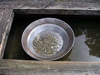
Gold prospecting is the act of searching for new gold deposits. Methods used vary with the type of deposit sought and the resources of the prospector. Although traditionally a commercial activity, in some developed countries placer gold prospecting has also become a popular outdoor recreation. Gold prospecting has been popular since antiquity. From the earliest textual and archaeological references, gold prospecting was a common thread for gaining wealth.

Exploration geophysics is an applied branch of geophysics and economic geology, which uses physical methods at the surface of the Earth, such as seismic, gravitational, magnetic, electrical and electromagnetic, to measure the physical properties of the subsurface, along with the anomalies in those properties. It is most often used to detect or infer the presence and position of economically useful geological deposits, such as ore minerals; fossil fuels and other hydrocarbons; geothermal reservoirs; and groundwater reservoirs. It can also be used to detect the presence of unexploded ordnance.

<span class="mw-page-title-main">Magnetotellurics</span> Electromagnetic geophysical technique

Magnetotellurics (MT) is an electromagnetic geophysical method for inferring the earth's subsurface electrical conductivity from measurements of natural geomagnetic and geoelectric field variation at the Earth's surface.

Botanical prospecting for uranium is a method of finding uranium deposits either by observation of plant life growing on the surface, or by geochemical analysis of plant material in a process known as Geobotanical prospecting.

Kambalda type komatiitic nickel ore deposits are a class of magmatic iron-nickel-copper-platinum-group element ore deposit in which the physical processes of komatiite volcanology serve to deposit, concentrate and enrich a Fe-Ni-Cu-(PGE) sulfide melt within the lava flow environment of an erupting komatiite volcano.

Geobotanical prospecting refers to prospecting based on the composition and health of surrounding botanical life to identify potential resource deposits. Using a variety of techniques, including indicator plant identification, remote sensing and determining the physical and chemical condition of the botanical life in the area, geobotanical prospecting can be used to discover different minerals. This process has clear advantages and benefits, such as being relatively non-invasive and cost efficient. However, the efficacy of this method is not without question. There is evidence that this form of prospecting is a valid scientific method, especially when used in conjunction with other prospecting methods. But as identification of commercial mines are invariably guided by geological principles and confirmed by chemical assays, it is unclear as to whether this prospecting method is a valid standalone scientific method or an outdated method of the past.

Geophysical survey is the systematic collection of geophysical data for spatial studies. Detection and analysis of the geophysical signals forms the core of Geophysical signal processing. The magnetic and gravitational fields emanating from the Earth's interior hold essential information concerning seismic activities and the internal structure. Hence, detection and analysis of the electric and Magnetic fields is very crucial. As the Electromagnetic and gravitational waves are multi-dimensional signals, all the 1-D transformation techniques can be extended for the analysis of these signals as well. Hence this article also discusses multi-dimensional signal processing techniques.

Transient electromagnetics,, is a geophysical exploration technique in which electric and magnetic fields are induced by transient pulses of electric current and the subsequent decay response measured. TEM / TDEM methods are generally able to determine subsurface electrical properties, but are also sensitive to subsurface magnetic properties in applications like UXO detection and characterization. TEM/TDEM surveys are a very common surface EM technique for mineral exploration, groundwater exploration, and for environmental mapping, used throughout the world in both onshore and offshore applications.

<span class="mw-page-title-main">Geological Survey of Sweden</span> Swedish government agency for matters concerning geology.

not to be confused with the Geologiska föreningen

<span class="mw-page-title-main">Outline of geophysics</span> Topics in the physics of the Earth and its vicinity

The following outline is provided as an overview of and topical guide to geophysics:

Dan Hausel a polymath of martial arts, geology, writing, astronomy, art, and public speaking. Hall-of-Fame 10th degree black belt grandmaster of Shorin-Ryu Karate and Kobudo, mineral exploration geologist who made several gold, colored gemstone, and diamond deposit discoveries in Alaska, Colorado, Montana and Wyoming, author of more than 600 publications including books, maps, professional papers and magazine articles, public speaker, artist, former astronomy lecturer for the Hansen Planetarium in Utah, and former rock musician.

References

  1. "Mining - Prospecting and exploration". Encyclopedia Britannica. Retrieved 2020-02-29.
  2. "Mineral Tenure Act". www.bclaws.gov.bc.ca. Retrieved 2024-02-08.
  3. Fiji through a Prism of Geology and Mines Inspection. Chapter 5 in: White F. Miner with a Heart of Gold: biography of a mineral science and engineering educator. Friesen Press, Victoria. 2020. ISBN 978-1-5255-7765-9 (Hardcover) 978-1-5255-7766-6 (Paperback) 978-1-5255-7767-3 (eBook)
  4. Cabello, J. (2022). Reserves, resources and lithium exploration in the salt flats of northern Chile. Andean Geology . 49 (2): 297–306. doi: 10.5027/andgeoV49n2-3444. Retrieved July 2, 2022.
  5. Dobrin, Milton B. (1960). Introduction to Geophysical Prospecting . New York, McGraw-Hill.
  6. Farquharson, Colin; Craven, James (August 2009). "Three-dimensional inversion of magnetotelluric data for mineral exploration: An example from the McArthur River uranium deposit, Saskatchewan, Canada". Journal of Applied Geophysics. 68 (4): 450–458. Bibcode:2009JAG....68..450F. doi:10.1016/j.jappgeo.2008.02.002.
  7. Shi, Yuan (January 2020). "Three-dimensional audio-frequency magnetotelluric imaging of Zhuxi copper-tungsten polymetallic deposits, South China". Journal of Applied Geophysics. 172: 103910. Bibcode:2020JAG...17203910S. doi:10.1016/j.jappgeo.2019.103910.
  8. Singh, Anand; Sharma, S.P. (2015). "Fast imaging of subsurface conductors using very low-frequency electromagnetic data". Geophysical Prospecting. 63 (6): 1355. Bibcode:2015GeopP..63.1355S. doi:10.1111/1365-2478.12323. S2CID   131284478.
  9. Wang, Nan (2017). "Passive super-low frequency electromagnetic prospecting technique". Frontiers of Earth Science. 11 (2): 248–267. Bibcode:2017FrES...11..248W. doi:10.1007/s11707-017-0597-4. S2CID   113545890.
  10. Van Der Kruk, J (2002). "An apparent-resistivity concept for low-frequency electromagnetic sounding techniques". Geophysical Prospecting. 48 (6).
  11. Fletcher, W.K. Analytical Methods in Geochemical Prospecting.